The last hot day for a while.
A high of 86 degrees today with the possibility of a shower or thunderstorm; kind of like yesterday evening. After that we cool down significantly. Friday night's low will be near 57 degrees. Woop-woop!
Do you miss the 90's?
The hot 90+ degree summer days, not the 1990's. I do but there's good news for you all that hate the heat. After looking at the long range data it's possible that the worst of summer is over. I mentioned this cooler trend a couple of weeks earlier. This is not to say that we won't see and occasional 88 or 89 or 90 degree day from now on but only to say that the 90 degree plus heat (90 - 95) for days on end is likely over. In fact, the NWS's CPC gives us a cooler than average start to open August. Here's the 8-14 day outlook.
Severe storms are possible in Bloomington today!
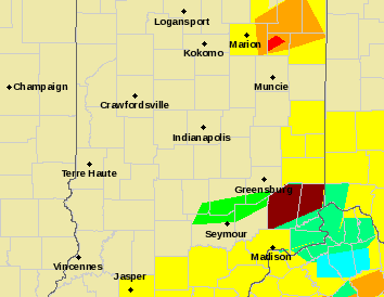
Be on the lookout for severe weather today. I think you should pay special attention to the 4-8pm time frame.
Here's the latest info from the NWS:
Here's the latest info from the NWS:
Issued at 351 AM EDT Fri Jul 20 2018

A unseasonably strong low pressure system moving through the
Great Lakes and into the Ohio Valley will bring showers and
thunderstorms to central Indiana for the weekend, as well as the
potential for severe storms today. After today temperatures will
drop to below normal for the remainder of the weekend before
returning to normal for the work week. Next week looks mainly dry
after Monday.
My map looks a little different from the one the NWS has issued. I think the storms with stack more
vertically and to out east like this:
One more hot day before a brief cool down.
A high of 93 degrees today. Temperatures cool off a little bit by the middle of next week. High temperatures will be in the lower 80's next Wednesday, Thursday and Friday.
The patterns looks like it will relax a little bit and we'll see slightly cooler than normal temperatures during the last week of July.
The patterns looks like it will relax a little bit and we'll see slightly cooler than normal temperatures during the last week of July.
Watch out for Beryl.
Hurricane Beryl is the first of the season that's making it's way across the Atlantic. It is expected to weaken as it approaches and there is no threat to the US at this time.
July 4th will be hot!
The high temperature will be 94 degrees with a heat index of 107. Drink plenty of water if you're going to be out watching the parade.
A slight cool down this weekend with Saturday's high reaching 81 and Saturday's nights low reaching 60.
What does it feel like?
No matter what season we're in there's always a difference between the actual temperature and what it "feels like". In the winter months wind-chill charts are used to calculate what the temperature feels like on exposed skin. Most people have either heard about or seen a wind-chill chart. If not, here is an example of one:
During the summer months a heat index chart is used to calculate what the temperature "feels like". The heat index chart plots the actual temperature against the dew-point to give a temperature of what it feels like outside on exposed skin. Dew-points are important for a lot of reasons but in this case they measure the actual moisture content in the air rather than the water vapor in the air. The measure of the amount of water vapor in the air is often referred to as "Relative Humidity". This is misleading because it is not nearly as accurate as dew-points. When actual temperatures are plotted against dew-points you get a chart like this one:
This is how the NWS decides to issue a Heat Advisory or Warning. Generally speaking, dew-points in the mid 60's are considered comfortable. If you have real temperatures in the 90's and dew-points in the 70's then it typically feels like 100 degrees or more.
I hope this has been helpful. I sure wish it was 40 degrees with 2mph winds today don't you?
Subscribe to:
Comments (Atom)


