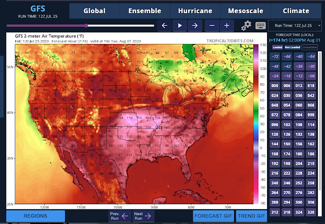
The weather computer models were advertising extreme heat back in late June and then subsequently pushing that date off for a week. Heat advisories are not out yet for Bloomington but I expect them to be posted for much of Indiana very soon.
#BOTS fans!
Weather dot com is already talking about the upcoming winter season.
Winter 2023-24
Most El Niños hit their peak in late fall or winter and thus have their strongest influence on weather patterns in the colder months.
The classic El Niño winter is rather warm from Alaska into western and central Canada and then into the northern tier of states from the Pacific Northwest to the western Great Lakes.
It tends to be colder and wetter than average through much of the southern U.S., particularly from Texas to the Carolinas. We found that some cities in the Southwest, Southern Plains and mid-Atlantic have their snowiest winters during El Niño.
https://weather.com/news/climate/news/2023-06-08-el-nino-has-developed
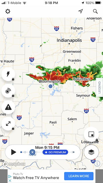
Tornado sirens just sounded in Bloomington, Indiana.
We were already under a Severe Thunderstorm Watch but not a Tornado Watch. Here is what I captured.
In other weather news, let's hope the heat stays in the southwest. The GFS has been hinting at a northeast shift since late June.
Here's the latest thoughts from the NWS:
Long Term...(Tuesday night through Monday)
Issued at 307 PM EDT Mon Jul 17 2023

The long term will span the final days of the year`s
climatologically hottest period...yet temperatures are progged to
continue their near, to at times slightly below normal trend.
Synoptically, a rather broad H500 trough will prevail over the
eastern half of North America...while a hot upper ridge centered
near the Four Corners extends northward into southwestern Canada.
With the inflection point amid this wave hinged near Iowa, central
Indiana will generally be influenced by weak disturbances embedded
in the flow of the trough`s southwestern quadrant.

Tuesday Night through Thursday...

A more active pattern is expected for the mid-week as the upper
trough first becomes better established near/east of the region.  A
more zonal pattern that should hold pronounced heat just to our
south and west...will nevertheless focus so-called ridge-riding
convective chances from the Middle Mississippi Valley towards
Kentucky.  This conditional opportunity for isolated to scattered
showers/t-storms will be focused across southern portions of Indiana
where deep moisture levels will approach 2.00 inches.  Convective
parameters will present conditional potential both days...with
daytime CAPE ranging from around 1000 J/kg (Wednesday) to 2000 J/kg
(Thursday)...with decent mid-level lapse rates Wednesday and
lackluster amounts Thursday...yet all while the ridge gradient`s
presence brings adequate vertical wind shear over the region both
days.  Late Thursday`s storm potential could also be enhanced by the
trough`s weak wave/boundary passing just north of the region.
Marginal severe threats would be primarily wind and large hail with
limited amounts of low-level shear. The Wednesday night-Thursday
tandem are expected to be the warmest of the long term, with lows 65-
70F and highs in the mid to upper 80s...with other periods at least
a couple degrees lower amid this continued seasonable stretch of mid-
summer conditions.

Friday through Monday...

A somewhat drier column will accompany seasonably weak, yet rather
broad surface high pressure that should cross the Midwest late this
week.  Guidance is continuing to show a transition early next week
as lower heights slide east and the hot, western ridge perhaps
finally builds towards the Midwest.  At a first glance a few pulse
storms cannot be ruled out as a more summery pattern returns, with
what should be low-moderate levels of both instability and wind
shear.  Most days surrounding this weekend are expected to bring
highs 80-85F and lows 60-65F.
Subscribe to:
Comments (Atom)


