Tornado Warning
INC013-055-093-105-051900-
/O.NEW.KIND.TO.W.0027.171105T1819Z-171105T1900Z/

BULLETIN - EAS ACTIVATION REQUESTED
Tornado Warning
National Weather Service Indianapolis IN
119 PM EST SUN NOV 5 2017

The National Weather Service in Indianapolis has issued a

* Tornado Warning for...
  Southern Monroe County in south central Indiana...
  Southwestern Brown County in south central Indiana...
  Northern Lawrence County in south central Indiana...
  Southeastern Greene County in southwestern Indiana...

* Until 200 PM EST

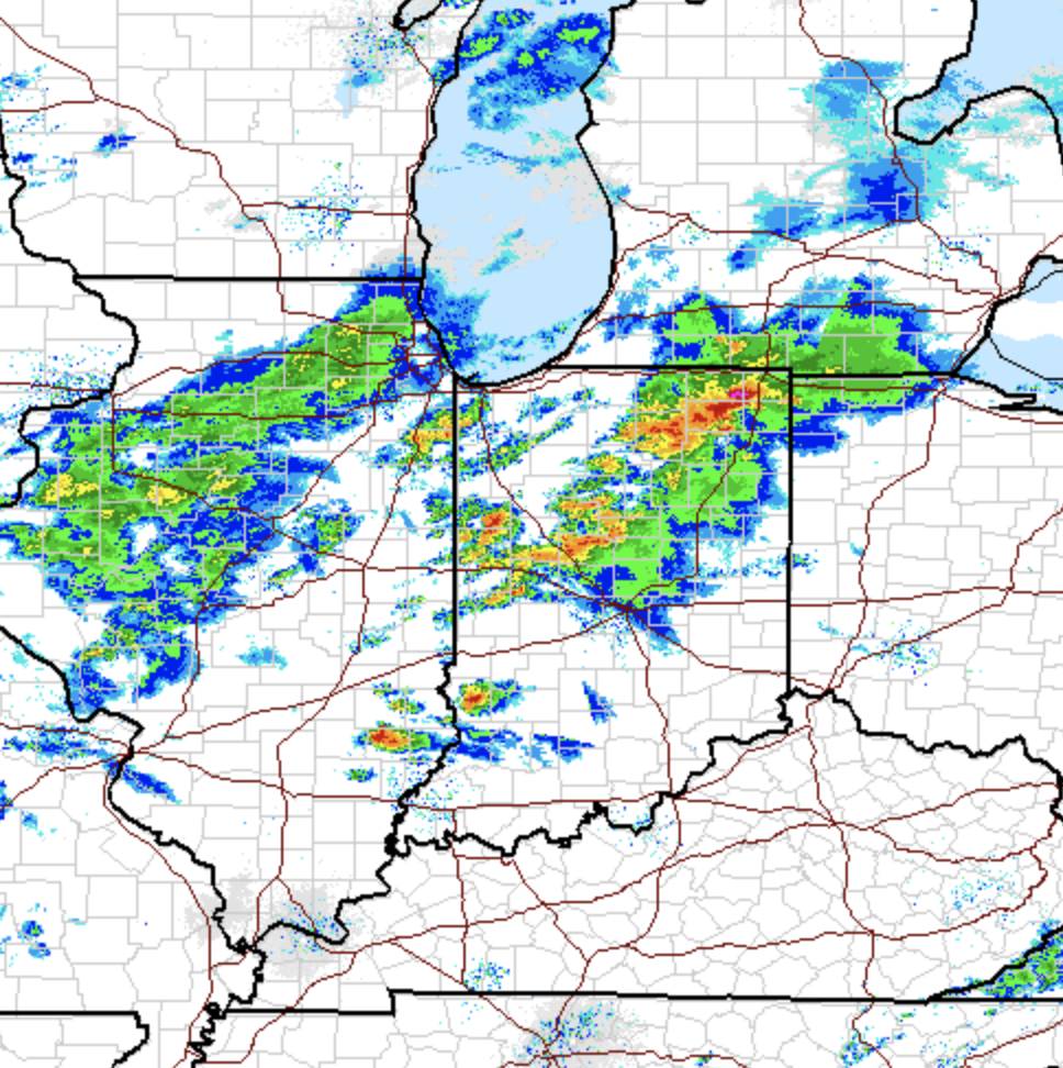
* At 119 PM EST, a severe thunderstorm capable of producing a tornado
  was located 12 miles northwest of Bedford, moving east at 30 mph.

  HAZARD...Tornado and quarter size hail.

  SOURCE...Radar indicated rotation.

  IMPACT...Flying debris will be dangerous to those caught without
           shelter. Mobile homes will be damaged or destroyed.
           Damage to roofs, windows, and vehicles will occur.  Tree
           damage is likely.

* This dangerous storm will be near...
  Avoca around 125 PM EST.
  Oolitic and Harrodsburg around 130 PM EST.
  Fairfax State Recreation Area and Smithville around 135 PM EST.
  Monroe Reservoir and Bartlettsville around 140 PM EST.
  Heltonville around 145 PM EST.
  Charles Deam Wilderness and Woodville Hills around 150 PM EST.

PRECAUTIONARY/PREPAREDNESS ACTIONS...

TAKE COVER NOW! Move to a basement or an interior room on the lowest
floor of a sturdy building. Avoid windows. If you are outdoors, in a
mobile home, or in a vehicle, move to the closest substantial shelter
and protect yourself from flying debris.

&&

LAT...LON 3890 8668 3890 8673 3905 8677 3919 8628
      3905 8628 3905 8632 3899 8632 3899 8628
      3892 8628 3888 8668
TIME...MOT...LOC 1819Z 256DEG 28KT 3899 8665

TORNADO...RADAR INDICATED
HAIL...1.00IN
Stuck at the Monroe County Public Library @1:32PM due to Tornado Warning.
Great time to test the new AccuWeather Iphone Weather App.
It predicts hail to start at exactly 1:33pm today. Oh well, be safe.

Update: @1:58pm, there were reports of golf ball sized hail!

Update: @1:58pm, there were reports of golf ball sized hail!
@12:22pm Wind gust picking up.
Given the likelihood of strong storms, damaging winds and the possibility of tornadoes, I would recommend taking this down.

I hope it does not topple over.

I hope it does not topple over.
Tornado Watch is now in effect until 7:00pm for central Indiana, BOTLO!
TORNADO WATCH OUTLINE UPDATE FOR WT 511
NWS STORM PREDICTION CENTER NORMAN OK
1210 PM EST SUN NOV 5 2017

TORNADO WATCH 511 IS IN EFFECT UNTIL 700 PM EST FOR THE
 FOLLOWING LOCATIONS

INC001-005-009-011-013-015-021-023-027-029-031-035-041-045-047-
053-055-057-059-063-065-067-071-075-079-081-083-093-095-097-101-
105-107-109-119-121-133-135-137-139-145-153-157-159-161-165-167-
171-177-179-060000-
/O.NEW.KWNS.TO.A.0511.171105T1710Z-171106T0000Z/

IN
.    INDIANA COUNTIES INCLUDED ARE

ADAMS                BARTHOLOMEW         BLACKFORD
BOONE                BROWN               CARROLL
CLAY                 CLINTON             DAVIESS
DEARBORN             DECATUR             DELAWARE
FAYETTE              FOUNTAIN            FRANKLIN
GRANT                GREENE              HAMILTON
HANCOCK              HENDRICKS           HENRY
HOWARD               JACKSON             JAY
JENNINGS             JOHNSON             KNOX
LAWRENCE             MADISON             MARION
MARTIN               MONROE              MONTGOMERY
MORGAN               OWEN                PARKE
PUTNAM               RANDOLPH            RIPLEY
RUSH                 SHELBY              SULLIVAN
TIPPECANOE           TIPTON              UNION
VERMILLION           VIGO                WARREN
WAYNE                WELLS
$$
BOLO for tomorrow!
Be on the look out for strong storms and possible tornadoes throughout the state Indiana tomorrow. The National Weather Service has placed us under an "enhanced risk" for severe weather. It's been a while since we've been under an enhanced risk. We see a lot of marginal and slight risks but this is to be taken seriously.


The NWS forecast discussion:
.SHORT TERM /Tonight through Monday Night/...
Issued at 347 AM EDT Sat Nov 4 2017

Primary focus for the short term remains squarely on the threat for
severe weather and locally heavy rainfall Sunday afternoon and
evening as low pressure and a strong cold front swing through the
region.

Thick low level clouds will likely persist across the forecast area
tonight as model soundings maintain a subtle yet shallow inversion.
Convective potential increases once again after midnight in response
to a low level jet surge spreading over the area and a subtle
surface wave tracking from central Illinois northeast into north
central Indiana in the vicinity of the warm front. Model soundings
show a developing area of weak elevated instability accompanying the
surface feature...primarily focused over northwest portions of the
forecast area. CAMs beginning to capture the idea of convection
increasing in coverage overnight with the potential for a few
lightning strikes. Just looking at the thermodynamic setup...a few
of the stronger storms could throw out small hail as well. Will
raise pops to likely over essentially the northwest half of the
forecast area from 06-12Z with scattered pops elsewhere. Showers and
storms may linger past daybreak Sunday over northern portions of the
area as continued low level forcing and broad ascent support
potential for additional convection.

The focus will shift to the potential for severe storms to impact
central Indiana...primarily during the afternoon and evening as low
pressure rides along the frontal boundary from the central Plains
into northern Indiana Sunday night. Enhanced low level flow will
enable a progressively deeper layer of moisture and a broad elevated
mixed layer to advect into the Ohio Valley through the day. Despite
cloudy skies...the airmass should have no problem becoming modestly
unstable over most of the forecast area...with values peaking
between 1000-2000 j/kg by late day. Dynamics aloft remain very
good...with diffluence noted aloft over the region and a dual upper
jet structure that would support enhanced convective potential
focused over northern portions of Indiana and Illinois. BL shear and
storm relative helicity values are strongly supportive of the
potential for severe storms as well.

The primary tornado threat will likely align during the afternoon
and early evening in the vicinity of the warm front and immediately
ahead of the surface wave track. Confidence continues to increase in
the warm front setting up north of the forecast area over northern
Indiana. The greatest threat initially as convection develops during
the afternoon and migrates into the northern Wabash Valley may end
up being large and perhaps significant hail as mid level lapse rates
of 7-8C and higher are present over the region. Wet bulb zero values
between 8 and 9kft and the potential for nearly 10kft of the mid
levels within the hail growth zone both support the large hail
concern during the afternoon and early evening.

While supercellular structures are likely initially...support
pointing towards convection eventually aligning into a QLCS by early
evening with the primary severe threat shifting from large hail to
damaging winds as convection moves through the forecast area.
Isolated tornadoes remain a distinct possibility over central
Indiana into Sunday evening...especially considering the potential
for quick spinners to develop along the QLCS. That being said...the
continued presence of a subtle veer-back-veer wind profile and the
lack of an appreciable backing flow in the near surface layer both
suggest the tornado threat will be mitigated to some degree.

To recap...all modes of severe weather are on the table...but the
primary threat over central Indiana may be initially large hail
transitioning to damaging winds as the QLCS progresses across the
forecast area through the evening. An increase in the low level flow
with 850mb winds peaking at 50-55kts Sunday evening will maintain
convection into the night with intensity only decreasing slowly as
instability is gradually lost. The presence of the stronger low
level jet support the potential for heavy rainfall and localized
flooding Sunday night with max precip water values near the
climatological peak for early November.

Rain and lingering storms will be out of the forecast area prior to
daybreak Monday with the cold front settling over the Tennessee and
lower Ohio Valleys. A surface wave will drift into the Ohio Valley
along the boundary Monday night...providing a renewed threat for
showers focused over the southern half of the forecast area.

Temps...even with no sunshine expected Sunday...it will be
unseasonably warm as temperatures should warm into the lower and mid
70s with dewpoints into the 60s providing a distinctly muggy feel to
the air. Much cooler air will spread across the region in the wake
of the cold frontal passage with highs in the 50s. Lows tonight will
remain quite mild with the southerly flow in the warm sector...but
expect a return to lows primarily in the 40s by Monday night.
Overall...a general model blend matched up with low level thermals
nicely.

&&


Iowa State University - Iowa Environment Mesonet
This is a cool website with a lot of bells and whistles. I was able to generate some data from it based on others that I saw online. Can you believe it has been 608 days since our last winter storm warning? Hopefully that will change soon.


#BOTS fans in the area have to be getting excited right now.
For those of you that do not know, #BOTS has two meanings. On one hand it's for the snow lovers and means Bring On The Snow. On the other hand there are the snow haters and they prefer Bring On The Spring Season. So, are you a #BOTS fan with one "S" or with two?
Why today? Well the National Weather Service has added the possibility for a slight chance of rain and snow showers this weekend. The official forecast for a 20% chance of rain / snow showers on Sunday, October 29th. This will be our first in the area since back in March of this year.
From the NWS discussion board:
.LONG TERM /Thursday through Sunday Night/...
Why today? Well the National Weather Service has added the possibility for a slight chance of rain and snow showers this weekend. The official forecast for a 20% chance of rain / snow showers on Sunday, October 29th. This will be our first in the area since back in March of this year.
From the NWS discussion board:
.LONG TERM /Thursday through Sunday Night/...
Issued at 343 AM EDT Mon Oct 23 2017

The extended period will initially start out with dry conditions
due to brief ridging over the area and slightly warmer
temperatures in the 60s. However, the next system is progged to
enter the Upper Midwest by Friday, increasing rain chances and
lowering temperatures with an associated cold front. This colder
air could result in some snow showers mixed in with lingering rain
showers on Saturday night as a second upper low drops into the
region. Highs will only top off in the upper 40s/low 50s on
Saturday and Sunday with lows at the freezing mark on Saturday
night.
Subscribe to:
Posts (Atom)