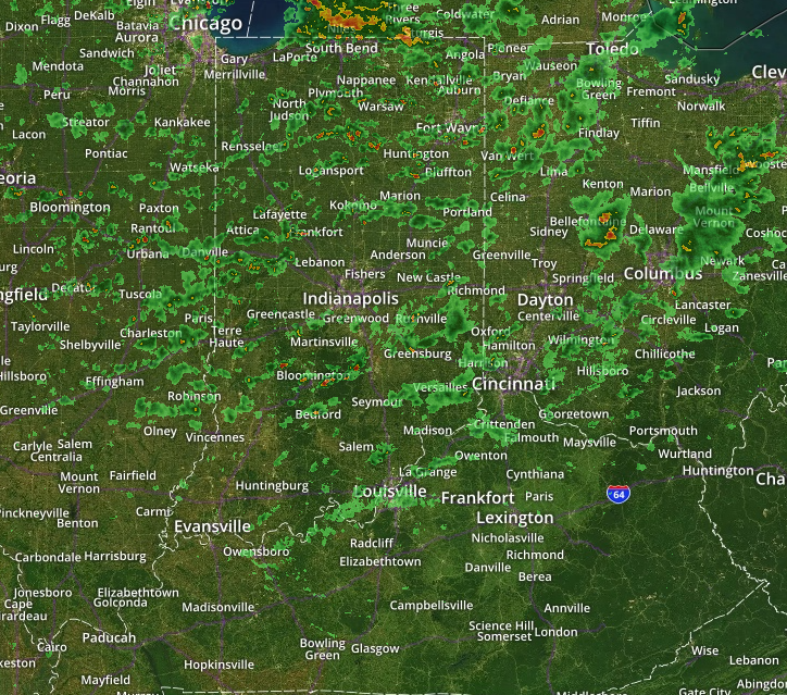
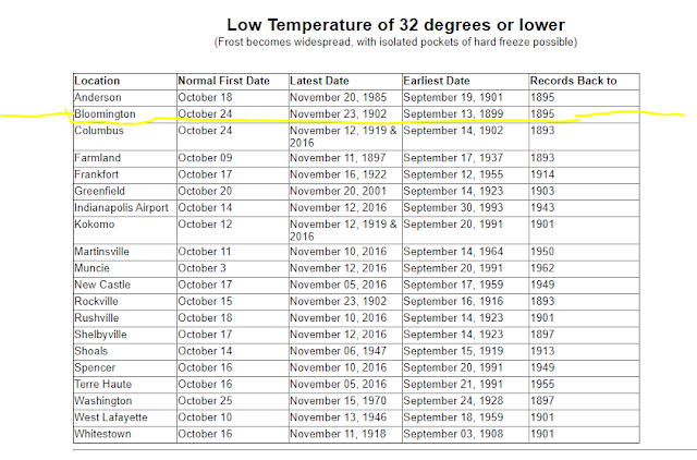
Frost and freeze warnings are out for Monroe County Indiana


Freeze Warning

URGENT - WEATHER MESSAGE
National Weather Service Indianapolis IN
335 AM EDT Thu Oct 15 2020

INZ021-028>031-035>049-051>057-060>065-067>072-151545-
/O.NEW.KIND.FZ.W.0007.201016T0600Z-201016T1400Z/
Carroll-Warren-Tippecanoe-Clinton-Howard-Fountain-Montgomery-
Boone-Tipton-Hamilton-Madison-Delaware-Randolph-Vermillion-Parke-
Putnam-Hendricks-Marion-Hancock-Henry-Vigo-Clay-Owen-Morgan-
Johnson-Shelby-Rush-Sullivan-Greene-Monroe-Brown-Bartholomew-
Decatur-Knox-Daviess-Martin-Lawrence-Jackson-Jennings-
Including the cities of Delphi, Flora, Williamsport,
West Lebanon, Lafayette, West Lafayette, Frankfort, Kokomo,
Attica, Covington, Veedersburg, Crawfordsville, Lebanon,
Zionsville, Tipton, Fishers, Carmel, Noblesville, Anderson,
Muncie, Winchester, Clinton, Newport, Rockville, Greencastle,
Plainfield, Brownsburg, Danville, Indianapolis, Greenfield,
Cumberland, New Castle, Terre Haute, Brazil, Clay City, Spencer,
Martinsville, Mooresville, Greenwood, Franklin, Shelbyville,
Rushville, Sullivan, Linton, Bloomfield, Bloomington, Nashville,
Columbus, Greensburg, Vincennes, Washington, Loogootee, Shoals,
Bedford, Mitchell, Seymour, Brownstown, and North Vernon
335 AM EDT Thu Oct 15 2020

...FREEZE WARNING IN EFFECT FROM 2 AM TO 10 AM EDT FRIDAY...

* WHAT...Sub-freezing temperatures as low as 30 expected.

* WHERE...Portions of central, east central, north central,
  south central, southeast, southwest and west central Indiana.

* WHEN...From 2 AM to 10 AM EDT Friday.

* IMPACTS...Frost and freeze conditions will kill crops, other
  sensitive vegetation and possibly damage unprotected outdoor
  plumbing.

* ADDITIONAL DETAILS...Rural areas and favored colder spots may
  see temperatures fall into the upper 20s.

PRECAUTIONARY/PREPAREDNESS ACTIONS...

Take steps now to protect tender plants from the cold. To prevent
freezing and possible bursting of outdoor water pipes they should
be wrapped, drained, or allowed to drip slowly. Those that have
in-ground sprinkler systems should drain them and cover above-
ground pipes to protect them from freezing.



Some eye candy for all the #BOTS fans out there.

This likely will not happen but it's great to see the GFS kick out a random snow event in our area this early.


Burl's Winter Weather Theory

Winter officially begins on Monday, December 21 at 5:02AM EST. 

Unofficially, meteorological winter starts on December 1 and ends on February 28.

I have a theory. I think the October weather pattern repeats itself as the official winter weather pattern. I don't have data to back this up so that is what I will be paying attention to this winter. If this month is any indication of the future, expect a rollercoaster of a ride with above average temperatures followed by below average temperatures. Here is the current October trend:


It's officially autumn.

 And 89 days until the winter solstice. 

I don't see any rain chances until September 30 to October 4. That's about it.

October 1st and 2nd will be cold at night. It looks like anywhere from 38-40 degrees.

Fall - part 2

It going to feel a lot like fall this weekend. Friday and Saturday night's low temperatures will get down to 45 degrees. The high temperatures will be 68. Get out and enjoy it with your mask on.

Because of our drought situation, this causes the leaves change colors and fall early on.


North Washington Street facing south. 


Check out this classic bow echo over Indiana


Our first real severe storm in Bloomington.

 My lights are flickering on and off as I type this but fyi, there are multiple hazards in effect. For Monroe County we have the following:

Severe Thunderstorm Watch until 1:00am

Severe Thunderstorm Warning until 8:30pm

Flash Flood Warning until 9:15pm

This hazardous weather outlook is for central Indiana.

.DAY ONE...This Afternoon and Tonight.

Outlook: Severe thunderstorms expected this evening.

Hazards: Widespread damaging winds likely, frequent lightning, and
heavy rain that may lead to localized flooding.

Timing: Primarily 6 to 11 PM. A second wave of storms may produce
primarily heavy rain across southwestern portions of central Indiana
after 3 AM.

Discussion: An approaching cold front has produced an extremely
strong line of severe thunderstorms to our northwest. This line of
storms is expected to move across portions of central Indiana in the
6 to 11 PM time frame, with widespread damaging winds likely.

.DAYS TWO THROUGH SEVEN...Tuesday through Sunday.

Outlook: Periodic thunderstorms are possible each day. Lightning and
heavy rain are possible with any thunderstorm.

Discussion: A front will linger in the area through the week,
keeping chances for thunderstorms in the forecast.

Relief is finally here plus a #BOTS update.

We're going to see highs in the upper 70's and low 80's this week. Isn't that great news? Tuesday night's low temperature will be 55 degrees. I don't know about you but that makes me want to get a blanket.

There's also an 80% chance for rain Monday night into Tuesday but we have been lacking in rainfall.

The hottest day of the week will be on Sunday, August 9th with a high of 86 degrees.

NOAA publishes long-range data on precipitation and temperatures up to six months out. People like to grab this data and start publishing summer outlooks in the winter and winter outlooks in the summer. Here is one such video published this summer for the upcoming winter:
https://www.youtube.com/watch?v=ZBYK-4V4vd4

#BOTS!