Sunshine and Flood Warning.

Enjoy the sunshine! I see people out running and walking today. Beware that the "Flood Warning" remains in effect until 8:15pm tonight. Rivers, creeks and streams will continue to rise downstream and in low-lying areas. According the National Weather Service Office in Indianapolis, we receive nearly 5 inches of rain and so the water has to go somewhere.


811 AM EST SUN FEB 25 2018

The National Weather Service in Indianapolis has issued a

* Flood Warning for...
  Monroe County in south central Indiana...
  Brown County in south central Indiana...

* Until 815 PM EST Sunday

* At 809 AM EST, automated gauges reported flooding along some area
  streams, including Salt Creek and North Fork Salt Creek. Flooding
  is also likely occurring in low lying areas and valleys.

* Some locations that will experience flooding include...
  Bloomington, Nashville, Ellettsville, Stinesville, Indiana
  University, Smithville, Helmsburg, Lake Lemon, Beanblossom, Gnaw
  Bone, Harrodsburg, Spurgeons Corner, Yellowwood Lake, Spearsville,
  Monroe Reservoir, Fairfax State Recreation Area, Woodville Hills,
  Elkinsville, Charles Deam Wilderness and Stone Head.

PRECAUTIONARY/PREPAREDNESS ACTIONS...

Turn around, don`t drown when encountering flooded roads. Most flood
deaths occur in vehicles.

In hilly terrain there are hundreds of low water crossings which are
potentially dangerous in heavy rain. Do not attempt to cross flooded
roads. Find an alternate route.

Red Cross Help & more rain tonight before we get a much needed break.

Up to two inches of additional rainfall is possible tonight. Use extreme caution if driving tonight. There are multiple Red Cross shelters open in Indiana for flood victims. You can call the local Bloomington Red Cross at (812)-332-7292 and the National number is 1-(800)-RED-CROSS or 1-(800)-733-2777. Click on the link below to see a list of shelters open in Indiana.

http://www.redcross.org/get-help/disaster-relief-and-recovery-services/find-an-open-shelter

Strong storms are possible tonight.

Watch as a tight line of storms form over eastern Texas and gradually pushes eastwards.


What to expect next?

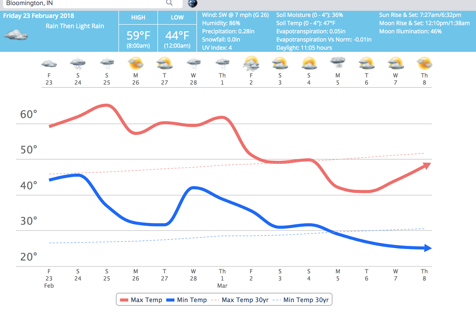
It's currently 55 degrees in Bloomington. It's cloudy and not raining as of 12:00p. We are under a flood watch until 7:00am Sunday morning. After that the pattern will moderate somewhat and we'll see more sunshine. There's a marginal risk for strong storms on Saturday so that's something to pay close attention to.


Winter will make it's return on March 2. The southeast ridge that is present now will break down on March 2. That is what has been giving us so much rain. After that happens, we'll see more cold weather. Take a look at these:


Flood Watch posted for Monroe County Indiana and most of central Indiana.

Heavy rain looks likey over our southern Indiana counties.


Here's the Flood Watch statement:

...FLOOD WATCH IN EFFECT FROM 10 PM EST THIS EVENING THROUGH
SUNDAY MORNING...

The National Weather Service in Indianapolis has issued a

* Flood Watch for portions of central Indiana, east central
  Indiana, south central Indiana, southeast Indiana, southwest
  Indiana, and west central Indiana, including the following
  areas, in central Indiana, Bartholomew, Decatur, Hancock,
  Hendricks, Johnson, Marion, Morgan, Rush, and Shelby. In east
  central Indiana, Henry. In south central Indiana, Brown,
  Jackson, Lawrence, and Monroe. In southeast Indiana, Jennings.
  In southwest Indiana, Daviess, Greene, Knox, Martin, and
  Sullivan. In west central Indiana, Clay, Owen, Putnam, and
  Vigo.

* From 10 PM EST this evening through Sunday morning

* Rainfall of 2 to 3 inches or more is expected through Sunday
  morning, in areas that have already received as much as 4 inches
  of rainfall in the last week. This will likely worsen flooding
  on area waterways and lead to flooding of other streams, low
  lying areas, and poor drainage areas.

PRECAUTIONARY/PREPAREDNESS ACTIONS...

A Flood Watch means there is a potential for flooding based on
current forecasts.

You should monitor later forecasts and be alert for possible
Flood Warnings. Those living in areas prone to flooding should be
prepared to take action should flooding develop.

Saturday @ 11:45am - Snow is sticking on trees, grass and cars.


At 11:00am it is currently snowing in Bloomington, Indiana

The temperature is 32 degrees. I'll take snow over freezing rain any day. From 60 degrees to snow showers in just a few days; boy this is definitely Indiana weather.

The hi-res NAM model was correct for it modeling of snow today back on Thursday.

The warm air will return on Monday and stick around for the next two weeks. There will be small intrusions of cod air but the overall pattern for the next two weeks will be near to above normal temperatures and lots of rain next week.

Winter is not over as can been seen by looking outside your window right now. Beyond the two week period there are signs that the cold air will make come-back around Friday March 2 or Saturday March 3rd. (See the GFS 2M A.T. below)


Will the snow return after March 4th? That is too far out to tell with any degree of certainty but one long range model hints at it. Again, a lot can change in two weeks so this is not set in stone.


Flip-flop?

The indices that were indicating a cold return flipped to a warmer and wetter pattern over the weekend. This is an example of how quickly things can change. All indications are that it will be rainy and warm until the first of March. It's okay #BOTS fans; winter is not over.

Also, watch out for potholes. Does anyone else notice their memory improving when detecting where the potholes are in Bloomington?

Freezing rain in Bloomington right now.

There’s freezing rain happening in Bloomington right now. Main roads are fine but side walks, bridges and grassy areas are slick. Traffic is not too bad on the south side near Starbucks. It should be over by noon.