Early morning thoughts.

There's some ice on the grass and sidewalks in Bloomington but streets seem fine. There's also ice on cars but it is fairly easy to clean off.


If you're an old guy like me, you might want to get some ice cleats this year. These help prevent falls and injuries.


One good thing about ice and snow is that it put these guys out of business. (hopefully)


The wild weather will continue

There's a chance for some light ice /freezing rain between 5:00am and 9:00am Thursday morning. You'll  want to give yourself an extra 30 minutes before leaving for work.


There will be rain Friday and maybe even a thunderstorm Saturday with a high of 63 degrees. Check out how impressive this storm is. At certain points it moves backwards twice.


After this, it's back to cold rain and snow for next week. See the video below for an explanation.


Wild Weather in Bloomington.

It wasn't supposed to snow this morning and yet it's been snowing non-stop since 7:00am. It's going to warm up later this week but know one seems know what the high temperature will be this coming Saturday. There's a range of 53 to 63 degrees.

What a difference 24 hours can make.

Yesterday at 1:53pn it was sunny and 62 degrees and now at 11:08am it's 32 degrees and snowing. Good ol Indiana weather.

The Seesaw effect.

High temperatures will warm into the lower 50's by this weekend. Next week cold air will return with a chance for snow. Wash. Rinse. Repeat. That will be the seesaw-like pattern for the next few weeks and throughout the month of December. See if you can spot the examples of the "Seesaw Effect" below.


 Look at that pink stuff! (Above)


 Up and down.


Up and down again.


Rain from coast to coast north to south

Freezing temperatures into southern Alabama.


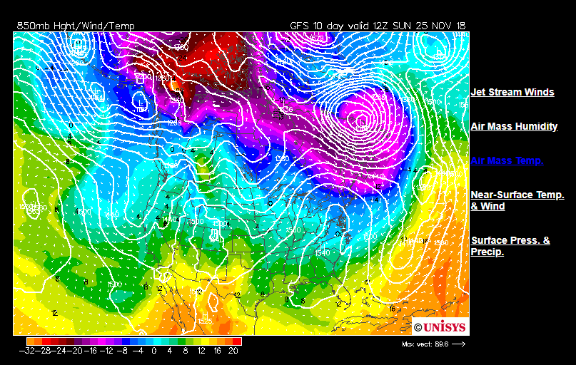
Our old friend from early October is trying to make a comeback.

Remember the southeast ridge that kept pumping in the heat during the first 10 days of October? Take a look at this temperature forecast for Sunday, November 25th.


Ice Storm Warning is in place in Bloomington until 12:00pm noon.

I just drove into town and the roads are in excellent condition because the road temperatures are between 36 and 38. There's lots of ice on trees, cars, power-lines and other objects.


Ice will change to all snow by 1:00pm today but I wouldn't expect too much more snow. The heaviest of the precipitation is off to our east. We are still in the center of the storm but the back side of storm does not have as much moisture as the front side. Classic rotated comma shape.


Also, there's another chance of ice Sunday evening into Sunday night. High temperatures will remain in the low 40's through Tuesday and them we begin a brief warming trend towards Thanksgiving.

#IDTP

I just made that up for "I Decline to Ponder / Pontificate". That's how I feel about the current system to our south. The storm system is so complex that forecasts range from all rain to nearly six inches of snow and everything in between with a mix of rain, sleet, snow and ice.

Why is it so complex to figure out? Because it is a cut-off low pressure system that is cut off from the jet stream or an attached cold front, it can meander in just about any direction it wants to. Yeah, it sounds like it has a mind of its own. Usually the upper level jet stream or, a warm front (mainly in summer) or, a cold front are the main drivers that push storms from west to east and south to north. That will eventually happen in this case but not before it wobbles around. As is wobbles around, it changes the temperature and precipitation on the east and west side of the wobble. Okay. I hope that's helpful.

Here's the current thinking from the NWS:

.SYNOPSIS...
Issued at 219 AM EST Wed Nov 14 2018

High Pressure in place across Illinois will push across Indiana
today bringing dry and cool weather today.

Strong Low pressure is expected to build across the deep south
tonight and push north across Kentucky and Tennessee. As the low
approaches...wintry precipitation is expected to across Indiana on
Thursday. This will result in some accumulating snow on Thursday
along with the possibility of some freezing rain.

The Low will quickly depart on Thursday night...ending the
precipitation and bringing dry weather for Friday and Friday
Night. Another weak cold front will sweep across Central Indiana
on Saturday which could bring more light precipitation along
followed by more cold weather for Sunday.

&&

.NEAR TERM /Today/...
Issued at 1041 AM EST Wed Nov 14 2018

Not much change to ongoing forecast. Did increase cloud cover
across the southern half of the forecast area to account for a
more invasive shield of mid to upper level clouds as the upper-
level system over the Arklatex region heads our way during the day
today. The northern edge of the mid to low deck associated with
this approaching system is currently located over southeast
Missouri into southern Illinois and southern Indiana. Expect the
cloudiness to continue across much of central Indiana
today...especially over the southern half of the area. Minor
changes to temps but kept highs in the middle 30s going...as
there was no appreciable change to the forecast that would warrant
an increase or decrease there.

&&

.SHORT TERM /Tonight through Friday Night/...
Issued at 219 AM EST Wed Nov 14 2018

The GFS and Nam suggest a strong Cut-off Low lifting out of the
plume of tropical moisture to the south and pushing toward and
across Tennessee and Kentucky late tonight through Thursday.
Strong indicators of plentiful moisture appear in place given the
flow aloft. Excellent forcing appears in place as the low
approaches and forecast soundings respond showing deep saturation
through the day on Thursday. Top-down methods suggest some
freezing rain will be possible on onset...particularly across the
southern half of the forecast area as moisture arrives. Given the
favorable expected path of the upper low...confidence is high for
precip however confidence remains low on amounts and type. At a
minimum...winter weather advisories will likely be needed and
possibly more across the south where ice may mix in. Thus will
stick close to the forecast builder blends pops tonight but trend
toward 100 pops on Thursday. Furthermore will trend lows warmer
and highs cooler than the blends given the expected clouds and
precip.

Best forcing exits the area quickly on Thursday night as the
upper low departs the area to the northeast. Dry air arrives
overnight as the Low reaches the middle Atlantic states. Although
some lingering precip could still be present the first few hours
after 00Z...the trend will be toward drying out. Forecast
soundings show drying and subsidence within the column. Thus may
keep a few pops across the east as the system departs but will
overall trend toward a becoming partly cloudy and dry forecast.
Given the possible snow on the ground and expected cold air
advection will trend lows cooler than the blends.

High pressure over the deep south on Friday and Friday night will
nose north into the Ohio Valley. Forecast soundings and mid level
guidance shows dry air and subsidence. Will trend toward a partly
cloudy day and temps at or below the model blends.

&&

.LONG TERM /Saturday through Tuesday/...
Issued at 232 AM EST Wed Nov 14 2018

Ensembles are in good agreement in keeping broad upper troughing
over the Midwest and East Coast during this period. There are still
timing differences among the individual members as to a weak short
wave trough that is expected to move through the area over the
weekend.

There continues to be a rather wide spread among the ensembles with
respect to the timing of the precipitation threat with the weekend
disturbance, anywhere from during the day Saturday to as late as
Sunday night. Don`t see any real trends yet one way or another,
so for now will go with chance PoPs for light mixed precipitation
at times from Saturday through Sunday night. Precipitation amounts
with this system still look to be on the light side.


Snow or no snow?

@7:53pm

The radar shows that there's snow over Bloomington right now but nothing is falling outside.

The air is just too dry for for snow. Look at this sounding:


The farther apart the green line is from the red line means the drier the atmosphere is. The closer together they are, the more saturated the atmosphere is. 15km is 9 miles up in the air. 0km is at ground level. So, between 0 and 3km; the air nearest the ground is very dry and snow is likely evaporating before it hits the ground.

Did you see it?

Last night around 8:00pm there were light snow flurries. By 10:00pm there were snow showers for an hour. I would say this makes November 9th 2018 the first official day for a sticking snow in the fall season. Here's a picture from this morning.


Next, all eyes turn to Monday night as there is an 80% chance of snow falling after 9:00pm. I don't think anyone knows the exact amounts just yet but my guess is anywhere from 1-3 inches.

This pattern will slowly oscillate into a warmer pattern by the week of Thanksgiving. By then we could be seeing high temperature in the mid 50's.

Here's to the brave men and the crew of the "Big Fitz". Today is the anniversary of disappearance of the Edmund Fitzgerald.
https://www.youtube.com/watch?v=9vST6hVRj2A