The south western part of the state is under a heat advisory.

The good news is that after we make it through today, the heat will subside and give in to temperatures in the upper 70's and lower 80's. Be sure to drink plenty of water today and keep and umbrella handy.


Heat Advisory

URGENT - WEATHER MESSAGE
National Weather Service Indianapolis IN
952 AM EDT Thu Jul 29 2021

INZ028-029-035-036-043>045-051>053-060>063-067>071-292200-
/O.CON.KIND.HT.Y.0001.210729T1800Z-210730T0000Z/
Warren-Tippecanoe-Fountain-Montgomery-Vermillion-Parke-Putnam-
Vigo-Clay-Owen-Sullivan-Greene-Monroe-Brown-Knox-Daviess-Martin-
Lawrence-Jackson-
Including the cities of Williamsport, West Lebanon, Lafayette,
West Lafayette, Attica, Covington, Veedersburg, Crawfordsville,
Clinton, Newport, Rockville, Greencastle, Terre Haute, Brazil,
Clay City, Spencer, Sullivan, Linton, Bloomfield, Bloomington,
Nashville, Vincennes, Washington, Loogootee, Shoals, Bedford,
Mitchell, Seymour, and Brownstown
952 AM EDT Thu Jul 29 2021

...HEAT ADVISORY REMAINS IN EFFECT FROM 2 PM THIS AFTERNOON TO
8 PM EDT THIS EVENING...

* WHAT...Heat Index Values of 105 to 110 degrees.

* WHERE...Areas near and west of Interstate 65.

* WHEN...This afternoon.

* IMPACTS...Heat related illness may occur quickly for people
  and pets with prolonged outdoor exposure.

* ADDITIONAL DETAILS...Developing thunderstorms late this
  afternoon will result in temperatures not as hot.

PRECAUTIONARY/PREPAREDNESS ACTIONS...

Drink plenty of fluids, stay in an air-conditioned room, stay out
of the sun, and check up on relatives and neighbors. Young
children and pets should never be left unattended in vehicles
under any circumstances.

Take extra precautions if you work or spend time outside. When
possible reschedule strenuous activities to early morning or
evening. Know the signs and symptoms of heat exhaustion and heat
stroke. Wear lightweight and loose fitting clothing when
possible. To reduce risk during outdoor work, the Occupational
Safety and Health Administration recommends scheduling frequent
rest breaks in shaded or air conditioned environments. Anyone
overcome by heat should be moved to a cool and shaded location.
Heat stroke is an emergency! Call 9 1 1.

Welcome to the "Dog Days of Summer"

Typically July 3 - August 11 but we have been running two degrees cooler than normal and we've had above average rainfall. That all changes next week when the extreme heat moves in. We could see high temperatures in the mid 90's by Wednesday.

Short Term...(Today through Sunday)
Issued at 346 AM EDT Sat Jul 24 2021

Hot and humid conditions will start to really kick in this weekend.
Northwesterly flow aloft, ahead of a ridge, in addition to
southwesterly to southerly flow at the surface will combine to
advect warmth and moisture into the region. High temperatures will
range from the upper 80s to near 90 and some areas are expected to
have heat indices above 100 degrees both today and tomorrow
afternoon. Smoke will still cause hazy conditions aloft although
there will be more cloud cover this weekend than we have been seeing.

There is a chance of showers and thunderstorms from this afternoon
into tomorrow. Central Indiana could see a couple rounds of
precipitation, first would be this afternoon and then again starting
late in the evening along an upper wave. The northwest flow aloft
will be strengthening while a short wave extends towards Lake
Michigan. The precipitation associated with the short wave will
likely be stronger than the afternoon convection as there will be
better forcing and shear, as well as higher PWATs (greater than 1.5
inches). In the far northern counties of the forecast area, some
storms could include damaging winds and can`t completely rule out
some hail. Models do show the system losing its structure and
strength as it moves into central Indiana as diurnal cooling starts
and instability weakens. There are still discrepancies on timing for
when the main round of storms will move through so confidence is
lower at this time as to when move into the area from the NW and
when it will exit to the SE, but have PoPs going through much of the
day Sunday at this time.

&&

.Long Term...(Sunday night through Friday)
Issued at 346 AM EDT Sat Jul 24 2021

Not a lot will change in the long term with regard to the synoptic
scale. The upper pattern will be such that central Indiana will be
under northwest flow aloft and on the periphery of northern Great
Lakes and southern Canada jet stream. That said, upper waves diving
into the northeastern trough may allow the upper flow to veer enough
toward late next week for the area to be in a higher risk for
potential MCS tracks. In fact, instability progs, suggest the
veering flow may sweep a boundary through Thursday night as models
are show central Indiana under a stable atmosphere next Weekend.

Early in the long term, a weak boundary will likely be moving into
south central Indiana Sunday night and stall over the Missouri and
Tennessee Valleys by early next week. The front will be close enough
to warrant small PoPs south of Terre Haute and Rushville through
Monday. Otherwise, chance PoPs also look reasonable late next week
and weekend due to the favored upper flow and potential boundary
moving through. Beside that, would not rule out a few storms
midweek, but small scale waves too difficult to pick out or time in
the upper flow at this time for mention and the atmosphere may be
capped anyway with 700 millibar thermal ridge point in from the
western high pressure dome. This will also result in above to well
above normal temperatures through at least Wednesday with afternoon
highs in the upper 80s to middle 90s.

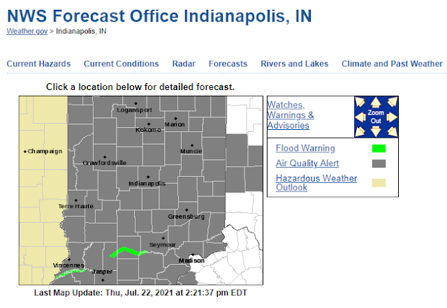
Smoke from wildfires out west creating haze in Indiana.

 The entire state is under an Air Quality Alert.


Air Quality Alert

Air Quality Alert Message
National Weather Service Indianapolis IN
1206 PM EDT Wed Jul 21 2021

INZ021-028>031-035>049-051>057-060>065-067>072-230400-
Carroll-Warren-Tippecanoe-Clinton-Howard-Fountain-Montgomery-
Boone-Tipton-Hamilton-Madison-Delaware-Randolph-Vermillion-Parke-
Putnam-Hendricks-Marion-Hancock-Henry-Vigo-Clay-Owen-Morgan-
Johnson-Shelby-Rush-Sullivan-Greene-Monroe-Brown-Bartholomew-
Decatur-Knox-Daviess-Martin-Lawrence-Jackson-Jennings-
Including the cities of Delphi, Flora, Williamsport,
West Lebanon, Lafayette, West Lafayette, Frankfort, Kokomo,
Attica, Covington, Veedersburg, Crawfordsville, Lebanon,
Zionsville, Tipton, Fishers, Carmel, Noblesville, Anderson,
Muncie, Winchester, Clinton, Newport, Rockville, Greencastle,
Plainfield, Brownsburg, Danville, Indianapolis, Greenfield,
New Castle, Terre Haute, Brazil, Clay City, Spencer,
Martinsville, Mooresville, Greenwood, Franklin, Shelbyville,
Rushville, Sullivan, Linton, Bloomfield, Bloomington, Nashville,
Columbus, Greensburg, Vincennes, Washington, Loogootee, Shoals,
Bedford, Mitchell, Seymour, Brownstown, and North Vernon
1206 PM EDT Wed Jul 21 2021

...AN AIR QUALITY ACTION DAY HAS BEEN DECLARED...

The officials at the Indiana Department of Environmental
Management have issued an Air Quality Action Day for...

Today and Thursday...July 21 and 22...for the entire state of
Indiana.

Levels of fine particles (PM2.5) are expected to be in the Orange
or Unhealthy for Sensitive Groups range. Active children and
adults, and people with respiratory disease, such as asthma should
limit prolonged outdoor exposure.

Here are some recommended actions that the public can take to reduce
fine particles and fine particle exposure:

     * Reduce activity time outdoors to reduce unhealthy exposure
       to PM2.5 and avoid exercising near busy roads.
     * Avoid burning wood and other unnecessary fires.
     * Avoid using the drive-through and combine errands into one trip.
     * Avoid refueling your vehicle or using gasoline-powered lawn
       equipment.
     * Turn off your engine when idling for more than 30 seconds.
     * Conserve energy by turning off lights or setting the air
       conditioner to 75 degrees or above.

For further information, please see the IDEM Smog Watch page on the
Internet at:

https://apps.idem.in.gov/smogwatch/

3-4 inches of rain between now and Sunday.

 See the full forecast discussion below for all the details.


National Weather Service Indianapolis IN
1230 PM EDT Fri Jul 16 2021

...Updated Aviation Discussion...

.Forecast Update...
Issued at 929 AM EDT Fri Jul 16 2021

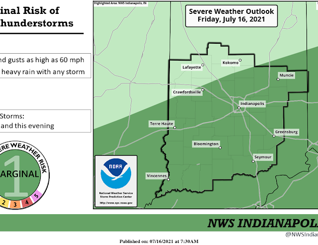
Short term models suggest a decent amount of lift is expected
across the forecast are today, courtesy of 850 mb flow of 25-30 kts.
This should result in periods of rain and thunderstorms across the
area for the rest of the day. Another convectively induced mid level
area of vorticity may be located over southwest Missouri at this
time. This feature may help to enhance the thunderstorm threat by
mid to late afternoon, as it drifts towards southwest Indiana. Will
continue with high PoPs today.

Precipitable waters analyzed around 1.75 inches this morning will
result in a continued locally heavy rain threat today. Despite lapse
rates close to moist adiabatic levels, marginal deep layer shear
exists over the local area, which may result in high wind threat
with any stronger convection that may develop. This maybe especially
true towards mid to late afternoon, with the approach of the mid
level feature over southern Indiana.

Given the expected clouds and precipitation today, the highs may be
too warm. However, they don`t have to rise too much to reach the
expected highs. Will leave the temperatures alone for now, and
monitor the trends.

&&

.Short Term...(Today through Saturday)
Issued at 304 AM EDT Fri Jul 16 2021

Surface analysis early this morning shows a weak frontal boundary in
place from northern MO...across Illinois to Central
Indiana...extending northeast to Lake Erie and southern Ontario. A
very warm and humid air mass was in place along and south of the
boundary with dew point temperatures in the upper 60s and lower 70s.
Radar shows ongoing convection...along and ahead of the front...from
Central Indiana upstream to southern IL and southern MO. Water vapor
shows a plume of moisture in place aloft from the American southwest
to MO...Indiana and southern Ontario.

Today the weak upper trough in place over the upper
midwest...sagging toward the Ohio Valley will be the main trigger
for ongoing convection across Central Indiana. Models suggest that
as the weak upper tough pushes across Indiana today...favorable
dynamics aloft will be in place through the day...before finally
exiting the area tonight. Forecast soundings ahead of this upper
trough reveal a very saturated column through the day with pwats
that are very moist...over 2.00 inches. Forecast soundings also
reveal attainable convective temperatures...but minimal CAPE. HRRR
suggests convection developing through the day as the boundary and
dynamics continue to linger across the area. Thus given the ongoing
returns on radar along with the expected development through the day
will trend pops near 100 today. As the system pushes to the east
through the day...will try to diminish pops from NW toward SE late
today...but best drying looks to arrive after 00Z.

Isolated Flash flooding could be a concern today given our high
pwats. However storm motion seems quick enough that storms should be
moving quickly across the area. Flash flooding will be more likely
in areas that are repeatedly struck with heavy rains. Will continue
to monitor for that.

Tonight...the models show the weak upper trough and associated
forcing pushing east of Indiana...allowing a dry NW flow to arrive
aloft. The dry NW flow looks to arrive near 03Z as that is when deep
moisture within the forecast soundings begin to be lost as pwats
fall to less than 1.5 inches. This drying within the column is an
indication of subsidence. Meanwhile within the lower levels the slow
moving frontal boundary is expected to sag to the Ohio
Valley...allowing the arrival of slightly cooler and less humid air.
Thus will keep the high pops in place after 00Z particularly across
the southeast where drying will arrive last. Will try to trend
toward a dry forecast by 12Z as any coverage at that point should be
isolated or less with arrival of less humid air and subsidence.

On Saturday...weak surface high pressure over the upper midwest and
Great Lakes looks to provide a cooler NE surface flow to Central
Indiana. However aloft a weak upper trough looks to be sagging south
out of the Great Lakes...providing cyclonic flow aloft. Forecast
soundings show plenty of dry air within the mid levels due to
ongoing subsidence...but do reveal some CAPE near 2000 J/KG and
attainable convective temperatures. Thus may include some slight chc
pops on Saturday afternoon for an isolated diurnal shower/storm.
Confidence is low for that.

&&

.Long Term...(Saturday night through Thursday)
Issued at 304 AM EDT Fri Jul 16 2021

The long term period will transition from generally slight chances
of showers/t-storms late this weekend...to 2-3 summer-like but rain-
free days to start the work week...before a return of slight chances
of storms mid/late week.  The threat of convection will have
diminished by Saturday night-Sunday, when the second part of this
weekend`s upper wave crosses the region...with quite dry mid-levels
bringing PWATs into the 1.00-1.50 inch realm in the wake of the cold
frontal passage. Nevertheless the small, but potent vort max could
shake out a few showers, especially over southeastern counties
Sunday afternoon. Low chances that any additional rains
will further flash flood potential.

Past isolated showers over southeastern counties on Monday, as the
last of the trough finally departs Indiana, the work week should
start rain-free.  Light northerly breezes, courtesy of surface high
pressure ridged along the western Great Lakes, will bring slightly
more comfortable dewpoints in the mid 60s.  The western ridge`s
eastern extent will be nudging into central Indiana, providing ample
sun and seasonable warmth.  The prevailing mid-level northwesterly
flow coming around the eastern side of the ridge will present the
potential of ridge-riding convection spilling into the Mid-West...
however kept POPs to slight chance or less to end the period given
low confidence.  Temperatures will not deviate far from normal for
the long term, with the CWA situated on the gradient between the hot
western US and milder Northeast.


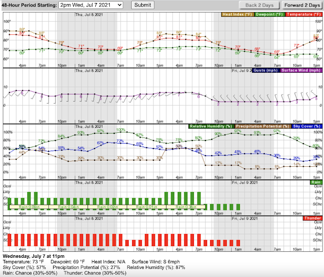
Rain and pop-up thunderstorms are possible between 4pm and 7pm today.


Has fall arrived early?

No! I wish. These are examples of what the cicadas left behind. The dead branches and leaves will eventually fall to the ground and then the nymphs / eggs on them will go into the ground and reemerge in 2038. Where will you be in the year 2038?


The cicadas are officially gone!

Now we are left with the tree damage they caused. You might see some patches of brown leaves or otherwise dying leaves in the trees. That is normal.

Weatherwise, this weekend is going to be spectacular! Get out and enjoy it. The heat returns by Tuesday.