320 PM EST Wed Feb 22 2023

...WIND ADVISORY REMAINS IN EFFECT UNTIL 10 PM EST THIS EVENING...

* WHAT...Southwest winds 15 to 25 mph with gusts to 45 to 50 mph
  expected.

* WHERE...Portions of central, east central, south central,
  southeast, southwest and west central Indiana.

* WHEN...Until 10 PM EST this evening.

* IMPACTS...Gusty winds could blow around unsecured objects.
  Tree limbs could be blown down and a few power outages may
  result.

* ADDITIONAL DETAILS...Any shower or thunderstorm that develops
  this evening will have the potential to produce even stronger
  wind gusts of up to 60 mph.

PRECAUTIONARY/PREPAREDNESS ACTIONS...

Use extra caution when driving, especially if operating a high
profile vehicle. Secure outdoor objects.
Who want to go Bryan Park and fly a kite with me?
Storm chasers are setting up in Salem, Indiana for tomorrow
For the record, the National Weather Service has not issued a Tornado Watch for tomorrow. It has not issued a Severe Storm Watch either. Nonetheless, storm chasers are setting up shop just to see what they can see. I would like to go but I have to work tomorrow. The image below is a computer sounding model for a random area in southeastern Indiana. See the possible hazard type.
Get ready for a wild ride over the next 48 hours!
A high of nearly 70 degrees today with 20MPH winds. Rain and thunderstorms tomorrow with a high of 63 degrees. Tomorrow night's low will be 27 degrees.
There is a very slight risk of tornadoes in the southeastern part of Indiana for Thursday evening. Cold fronts and warm fronts don't get along well together. Because of that (70 degrees to 27 degrees) you get severe weather. Here is what the National Weather Service thinks:
Area Forecast Discussion
National Weather Service Indianapolis IN
929 AM EST Wed Feb 15 2023

.Forecast Update...
Issued at 929 AM EST Wed Feb 15 2023

Little changes made to the forecast for the morning update. Current
surface analysis shows a strong area of low pressure near Marquette,
MI with a front extending southwest toward Missouri. Tight gradient
in the warm sector of the low combined with a strong low level jet
to 60 kts about 1 km agl has resulted in gusty winds through the
morning hours across Central Indiana. Highest wind gusts so far have
been around 45 kts, with the strongest gusts across the north and
eastern portions of Indiana. Strongest winds within the low level
jet are currently moving off to the northeast, so expect a slow
diminishing trend in wind gusts through the rest of the morning
hours and into the afternoon. Current IND ACARS sounding shows a
mixed layer up to about 1 km with steep low level lapse rates below
it. Despite weakening winds aloft, expect mixing to continue through
the day resulting in continued gusty winds to 20 to 35 mph into the
afternoon hours. Will let the Wind Advisory expire at 10 AM as wind
gusts over 45 mph will likely be infrequent going into the
afternoon.

Mixing heights are reaching into an extremely dry layer aloft, so
expect RH values to plummet this afternoon as temperatures rise and
dew points fall. Will be going well below guidance for dew points
during peak heating of the day. Despite drier air aloft, fire
weather concerns remain low due to RH values still in the 40s and
50s. High temperatures will likely be above guidance in this set up
into the 60s. Would not be surprised to see a few locations reach 70
for the first time this year across South Central Indiana!

&&

.Short Term...(Today Through Thursday)
Issued at 152 AM EST Wed Feb 15 2023

...GUSTY WINDS THROUGH MID-MORNING, STRONG TO SEVERE STORMS
THURSDAY...

Today.

Focus for today will be the exiting low pressure system that brought
rain to the area Tuesday evening and then the gusty winds through
the overnight hours.  For thoughts on the gusty winds through 15Z,
see the mesoscale discussion above.

The LLJ will gradually begin to relax after 15Z through the daytime
hours as the first low pressure system continues to push into
Southern Canada and the pressure gradients loosen.  Expect that
gusts up to 30 mph will continue through the early afternoon hours.

Skies will generally clear by mid morning with the loss of moisture
aloft, but a few lingering areas of clouds may continue into the
late morning across the northwestern counties.  Temperatures should
have no problem rapidly warming into the low to mid 60s for much of
the area with the potential for a few areas up to 70 degrees across
the south.

Tonight.

A second and more potent system then looks to follow a somewhat
similar path Wednesday night into Thursday with a much more robust
area of forcing to the south compared to the Tuesday night system.
Surface winds will briefly become northerly during the early
overnight hours ahead of this system which will end the WAA and
allow for a quick drop into the upper 30s to mid 40s before the
southerly flow returns.

A warm front associated with the aforementioned low pressure system
will push into the southern counties by around 09Z with periods of
light to moderate rain before the potential for strong to severe
storms during the afternoon hours tomorrow with southeastern Indiana
within the warm sector.

Thursday.

By 12Z Thursday, the surface low will be centered over southern
Illinois and will track across the I-70 corridor while gradually
strengthening through the afternoon hours.  A brief window for
strong to severe storms is possible starting initially in the
southwestern counties between 15Z and 18Z and then across the
southeastern counties between 18Z and 22Z. Storm motion will be
quick with speeds of 50-60mph likely.

Models are coming much closer in alignment for the severe potential
with around 50-70kts of effective bulk shear, 400-700 J/kg of CAPE,
and 200-300 m^2/s^2 of 0-1km helicity.  Current thoughts are in the
timeframes that were previously mentioned that isolated to scattered
discrete cells will push through with the potential for damaging
winds as the primary threat as well as a non-zero hail and tornado
threat.  SPC has placed portions of the area in an Enhanced Risk
which seems a little bullish based on the marginal thermal profile.

South central Indiana will be on the far northern edge of the severe
threat with much more favorable conditions south and east of the
forecast area.  Areas north of I-69 will generally be north of the
warm front with a lack of good moisture flow, so only expect showers
and a few rumbles of thunder. In addition to the severe threat,
gradient winds up to 40 mph are likely at times through the
afternoon hours with mixing down of the LLJ winds aloft. Quiet
conditions will then arrive by the evening hours as the storms push
through Ohio.

&&

.Long Term...(Thursday Night Through Tuesday)
Issued at 152 AM EST Wed Feb 15 2023

Thursday Night Through Sunday.

A quick blast of colder air arrives Thursday night, but even that is
just dropping temperatures to what is normal for this time of the
year.  Northwesterly wind gusts to 25 mph will bring wind chills
into the upper single digits to low teens Friday morning, but by
late Friday night flow will return to the south with warmer air
building in for the weekend.

Temperatures will warm into the mid 40s Saturday and then the low to
mid 50s on Sunday with plenty of sun each day.  A very subtle mid
level wave will bring some cirrus to the area Saturday night, but no
impacts are expected otherwise.

Monday and Tuesday.

The pattern then begins to become more active early next week as a
frontal system moves through the area.  There remains a fair amount
of uncertainty as to how much forcing and moisture will be available
along with the broader synoptic pattern, but think that a period of
rain is likely between late Monday and Tuesday.  The warmer than
normal pattern that has been in place through much of the month will
continue through early next week before cooling down to near normal
towards Wednesday.
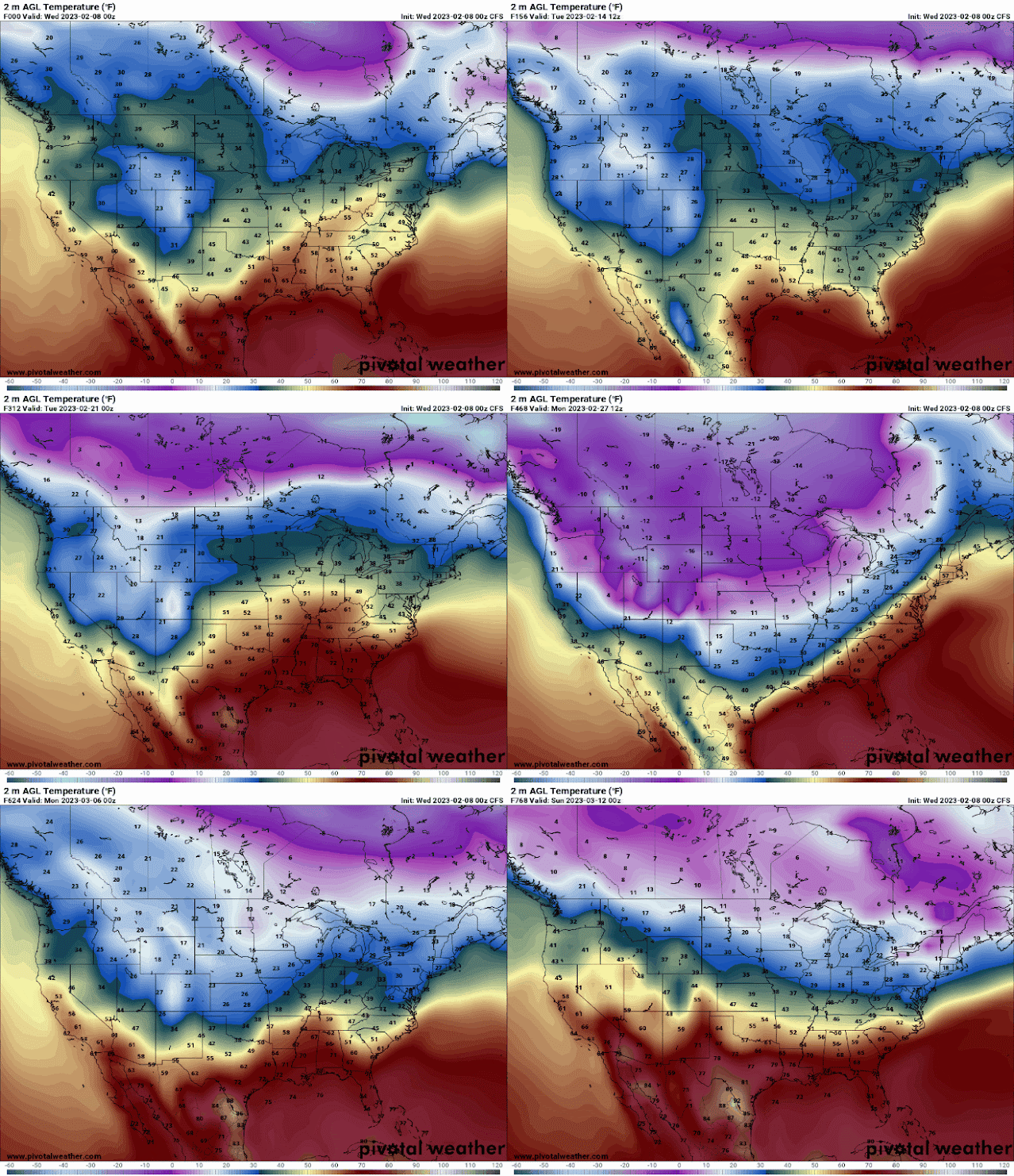
Winter is not over, just on hold and also, hold on to your hat!
The rollercoaster never ends! 40MPH winds, 1-2 inches of rain, thunderstorms tonight and tomorrow with a high of 60 degrees followed by near-freezing temperatures tomorrow night.
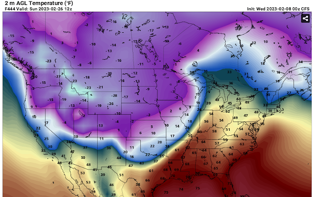
So where is winter? It's in Canada and in the north pole until about February 26th and then it will start to pay us a visit again.
There are hints of a snowstorm around March 5th. #BOTS!
Do you want to see the rollercoaster? Here are 768 hours of it, or about 32 days. It's not precise but you'll get the point.
Here is what the National Weather Service out of Indianapolis is thinking:
Short Term...(Today and tonight)
Issued at 342 AM EST Wed Feb 8 2023

Much of the day today will be calm as surface high pressure makes
it`s way through central Indiana. Winds this morning will be light
and variable as a result with partly cloudy skies to start off the
day. High temperatures today are expected to reach the upper 40s to
the low 50s.

A deepening low pressure system with a developing LLJ of 60-70 kts
will be moving into the region from the SW through the day. It will
bring with it rain, thunderstorms, and gusty winds both non-
thunderstorm and within the storms. The models look to be in good
general agreement on the placement of the low tracking just to the
east and then north of the forecast area, placing central Indiana in
the warm moist sector. Chances for rain will begin in our far SW
this afternoon, overspreading the whole area by the late evening
hours. As the associated warm front moves through, look to see
temperatures warm overnight and approaching 60 degrees by daybreak.
Non-thunderstorm winds will also be increasing through the night.
Expect gusts to increase above 20 mph after 8pm and then to increase
to 30 to 45 mph from midnight to daybreak Thursday. Within
individual thunderstorms, there could be isolated gusts higher than
45 mph after midnight as winds mix down.

Within this system, expect ample moisture transport supported by the
LLJ and leading to QPF values from three-quarters to 1.25 inches
with locally higher amounts possible.

&&

.Long Term...(Thursday through Tuesday)
Issued at 342 AM EST Wed Feb 8 2023

...HIGH WIND WATCH THURSDAY...

...WINDY/RAINY THURSDAY...

Thursday...

Models in great agreement that an occluded system/stacked low will
be over west central Illinois Thursday morning and move across Lake
Michigan, lower Michigan and to northern Lake Huron by Thursday
evening. Warm conveyor belt moisture will be near and northeast of
Interstate 65 Thursday morning and quickly move northeast of the
area during the afternoon along with the occluded front. Thus, will
start the day off with widespread rain near and northeast of the I-
65 corridor with residual chance PoPs southeast as a buffer.
Elevated instability within the warm conveyor belt supports thunder
mention, while strong pressure gradient lends good confidence to
non-thunderstorm wind gusts greater than 45 mph. After inter-office
coordination, will issue a Wind Advisory over our southern tier
and keep the current Watch in place further north from 12z-00z and
expand it one tier south. With the low level jet nosing into south
central Indiana, will start the Advisory at 09z

In addition to the wind threat, localized flooding may be ongoing
from the previous night`s rain with storm total rainfall in
excess of an inch over most of central Indiana based on the
combination of strong synoptic lift, deep moisture and elevated
instability. That said, moisture and lift associated with a TROWAL
should remain far enough north of the area for any wraparound with
central Indiana entrenched in the dry conveyor belt in the wake of
the occluded front.

Temperatures will start off very mild for this time of year but
quickly fall during the afternoon with a result of well above normal
and early day highs in the 50s to lower 60s but readings falling
through the 40s during the afternoon.

Thursday night...

As the occluded system moves well northeast of central Indiana, a
weak ridge will pass across from the southwest Thursday night and
combined with some drying of the column per BUFKIT soundings will
result in a dry Thursday night with west winds, albeit it weakening,
bringing back colder yet still above normal temperatures with
overnight lows in the 30s.

Friday and Friday Night...

Broad upper trough will slide southeast across the Great Lakes and
Ohio Valley. However, an embedded southwest upper low will result in
an non-phased system and in lack of Gulf inflow. Thus, kept only
small
Pops in for Friday. Modest north winds around a Plains and Missouri
Valley surface ridge will only allow temperatures to climb a few
degrees with slightly above normal highs in the upper 30s NW to
middle 40s SE. Meanwhile, overnight lows will fall back below
freezing to the middle and upper 20s with the N winds continuing and
some clearing as the ridge gets closer and column dries out per
BUFKIT soundings.

Rest of the weekend...

Ridging and will remain over the region through the
weekend and BUFKIT is indicating a dry column. This will result
in little cloud cover but with northeast winds, seasonable
temperatures Saturday. As the high moves by, the winds will shift to
the southwest and albeit less than 10 knots, help raise the
temperatures to well above normal with afternoon highs in the 40s
Sunday.

Monday through Tuesday night...

An upper wave will move across the Great Lakes Monday but with
moisture lacking, supply no more than increasing cloud cover.
However, Tuesday into Tuesday night, a strong southern system will
tap into the Gulf and pivot northeast across the Missouri and
Wabash Valleys Tuesday and Tuesday night. This system has the
potential for more widespread rain along with mild temperatures.
Stay tuned.
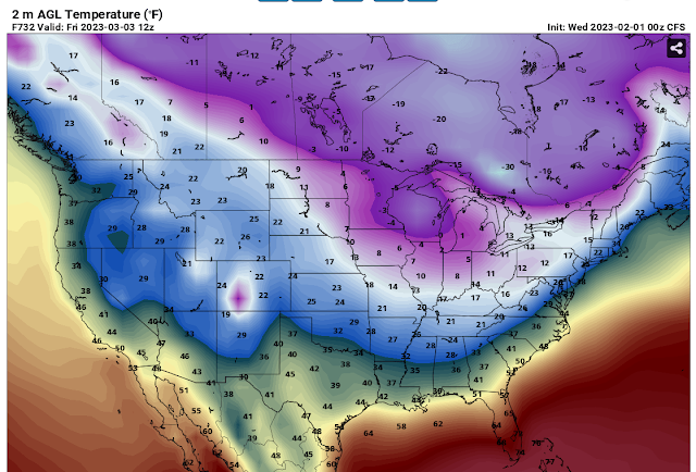
Cold and dry for the rest of this week.
.Long Term...(Thursday through Tuesday)
Issued at 244 AM EST Wed Feb 1 2023

- Dry and cold Thursday and Friday
- Dry and warmer weather Saturday through Monday
- Precipitation chances return Tuesday

Thursday and Friday...

There is high confidence that groundhogs across Central Indiana will
see their shadows on the morning of February 2nd. We also have high
confidence that meteorological spring will arrive on March 1st and
astronomical Spring will arrive on March 20th. Models show a large,
elongated  area of high pressure that will stretch from the middle
Atlantic States across KY to the southern plains. As forecast
soundings indicate a dry column, sunshine is expected on Thursday
morning allowing all kinds of creatures to see their shadows. Models
do show a weak cold front over the Great Lakes on Thursday morning,
connected to low pressure well to the north, near Hudson Bay.
Through this time, a southern branch of the jet stream aloft will
remain over the deep south, keeping any forcing dynamics well south
of Indiana. This along with the blocking surface high will prevent
moisture from arriving across Central Indiana as this cold front
passes on Thursday afternoon. Some high and mid clouds cannot be
ruled out along the front, so partly cloudy by afternoon and evening
should work well.

Moderate cold air advection arrives on Thursday Night and Friday as
a new area of arctic high pressure begins to build across the Ohio
Valley. Strong high pressure will develop across our area on Friday
as strong ridging aloft builds across the Rockies, while a deep
upper low resides over Quebec. This will result in subsidence and NW
flow across the upper midwest spilling into Indiana through Friday
night. Highs on Friday will once again be below normal and only
reach the 20s.

Saturday through Monday...

Models show the ridging within the upper flow breaking down on
Saturday as a short wave begins to push through the plains states.
This wave is suggested to push into the Ohio Valley on Sunday as
another quick moving and poorly organized cold front quickly drops
south across Indiana from the upper midwest. Caveat here is
moisture. The lower levels shows that Friday`s surface high will
be well southeast of Indiana on Saturday and Sunday, allowing the
return of moisture on southerly return flow. Forecast soundings at
this point fail to show deep moisture present but do show some
lower level saturation with the frontal passage. Pwats remain low.
Thus although some very light precipitation may be possible,
confidence remains low at this point. Will trend toward some
clouds on Sunday in the wake of the front.

Forecast soundings show drying and subsidence Sunday Night and
Monday as ridging builds aloft and surface high pressure is
suggested to push across the Great Lakes and Ohio Valley. Thus will
continue with dry weather on Monday.

Tuesday...

The next best chance for precipitation will be on Tuesday. The quick
moving ridge and surface high is depicted to push east as a stronger
short wave aloft is shown to push out of the plains and into the
Ohio Valley. Ample forcing is suggested to be present aloft, as a
well organized surface low and cold front approach central Indiana,
which will be in the warm sector. Thus with these favorable
ingredients at this juncture, we will continue to include chances
for rain along with warm temperatures on Tuesday.


