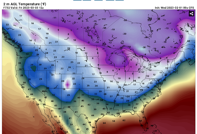
There's a lot of cold air bottled up in Canada and pieces of the cold energy will come down into the Midwest from time to time. The "Warm-for-10-days & Cold-for-10 days" pattern will persist into March. Usually there's a "Lover's Day" snowstorm on February 14th.💕 It looks like that might happen.
March 8th looks frigid but this is a long way off.
Here is what the NWS out of Indy thinks:
.Long Term...(Thursday through Tuesday)
Issued at 244 AM EST Wed Feb 1 2023

- Dry and cold Thursday and Friday
- Dry and warmer weather Saturday through Monday
- Precipitation chances return Tuesday

Thursday and Friday...

There is high confidence that groundhogs across Central Indiana will
see their shadows on the morning of February 2nd. We also have high
confidence that meteorological spring will arrive on March 1st and
astronomical Spring will arrive on March 20th. Models show a large,
elongated  area of high pressure that will stretch from the middle
Atlantic States across KY to the southern plains. As forecast
soundings indicate a dry column, sunshine is expected on Thursday
morning allowing all kinds of creatures to see their shadows. Models
do show a weak cold front over the Great Lakes on Thursday morning,
connected to low pressure well to the north, near Hudson Bay.
Through this time, a southern branch of the jet stream aloft will
remain over the deep south, keeping any forcing dynamics well south
of Indiana. This along with the blocking surface high will prevent
moisture from arriving across Central Indiana as this cold front
passes on Thursday afternoon. Some high and mid clouds cannot be
ruled out along the front, so partly cloudy by afternoon and evening
should work well.

Moderate cold air advection arrives on Thursday Night and Friday as
a new area of arctic high pressure begins to build across the Ohio
Valley. Strong high pressure will develop across our area on Friday
as strong ridging aloft builds across the Rockies, while a deep
upper low resides over Quebec. This will result in subsidence and NW
flow across the upper midwest spilling into Indiana through Friday
night. Highs on Friday will once again be below normal and only
reach the 20s.

Saturday through Monday...

Models show the ridging within the upper flow breaking down on
Saturday as a short wave begins to push through the plains states.
This wave is suggested to push into the Ohio Valley on Sunday as
another quick moving and poorly organized cold front quickly drops
south across Indiana from the upper midwest. Caveat here is
moisture. The lower levels shows that Friday`s surface high will
be well southeast of Indiana on Saturday and Sunday, allowing the
return of moisture on southerly return flow. Forecast soundings at
this point fail to show deep moisture present but do show some
lower level saturation with the frontal passage. Pwats remain low.
Thus although some very light precipitation may be possible,
confidence remains low at this point. Will trend toward some
clouds on Sunday in the wake of the front.

Forecast soundings show drying and subsidence Sunday Night and
Monday as ridging builds aloft and surface high pressure is
suggested to push across the Great Lakes and Ohio Valley. Thus will
continue with dry weather on Monday.

Tuesday...

The next best chance for precipitation will be on Tuesday. The quick
moving ridge and surface high is depicted to push east as a stronger
short wave aloft is shown to push out of the plains and into the
Ohio Valley. Ample forcing is suggested to be present aloft, as a
well organized surface low and cold front approach central Indiana,
which will be in the warm sector. Thus with these favorable
ingredients at this juncture, we will continue to include chances
for rain along with warm temperatures on Tuesday.


No comments:
Post a Comment