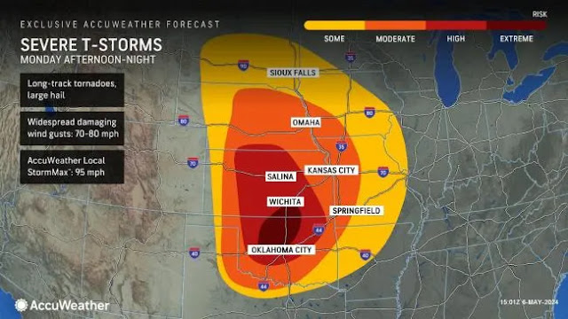
Indiana will see a chance of strong to severe storms on both Tuesday and Wednesday. If you have family living in Kentucky or Oklahoma, be sure and give them a call to warn them. Tornadoes are likely in those states and they should probably get a hotel in another state until the storms pass.
Here is what the National Weather Service is thinking about Indiana:
LONG TERM (Tuesday Night through Monday)...
Issued at 305 PM EDT Mon May 6 2024

Late Tuesday night through Wednesday night...

A break in convection is expected to start late Tuesday night, with
even weak ridging building into central Indiana from the subtropical
surface high pressure to our southeast.  Despite clearing skies,
lighter southwesterly breezes will hold dewpoints in the upper
50s...resulting in low temperatures around 60F across the region.

Wednesday will bring another favorable set-up for convection and
perhaps widespread severe weather with a warm frontal type boundary
likely slowly advancing northward near our southern counties ahead
of a strengthening surface low slowly approaching over the Middle
Mississippi Valley.  Much of the day Wednesday may be the quiet
before the storm as the narrow ridging between the two systems
continues to cross the CWA...albeit eventually self-destructive with
the bright skies bringing low 80s and light southerly winds holding
dewpoints in the 55-65F range.  Resultant CAPE by 21Z should range
from 1000-3000 J/kg from north-south...including moderately strong 7-
8 deg/km lapse rates over most of the area.  Widespread 40-55 kt 0-6
km shear will also support arriving/developing convection.

So far appears most likely storm pattern will be a mesoscale
convective system initiating in the afternoon somewhere in the
central/eastern Illinois region...before tracking eastward into
Indiana during the late day/early evening hours.  This would likely
transition into more of a heavy rain/flooding threat later in the
evening and into overnight hours, especially south of I-70 amid the
system`s warm sector`s anomalous precipitable water values
approaching 2.00 inches.  While the environment would support
discrete cells ahead of a later MCS arrival...organized severe
weather`s location would be dependent on warm frontal position, with
timing likely determined by where/when storms begin to fire to our
west.

All severe hazards are on the table for PM hours Wednesday with
damaging winds and large hail the greatest threats during the
afternoon/evening...and flooding the greatest concern for the
evening/overnight.  Although it is only early May, the set-up and
potential are perhaps more indicative of a June pattern with the
synoptic set-up able to effortlessly fuel ample deep moisture into
central and especially southern Indiana.  Rain chances will drop
from west to east late Wednesday night as the supporting surface low
crosses the state.  Total 24-hour rainfall potential for Wed-Wed
night will be 1.00-2.50 inches along/south of the I-70 corridor,
with less than 1.00 inch expected for most locations north of I-70.

Temperatures will be above normal amid the S/SW flow and overall
warm sector of the passing/approaching systems.  Expect low 80s
ahead of convection Wednesday...while lows Wednesday night amid
decreasing chances of rain ranging from the upper 50s near Lafayette
to the mid 60s south of the I-70 corridor.


Thursday through Monday...

The last five days of the long term will then trend to at least a
couple northern stream, positively-tilted short waves cycling from
the northern Plains into the Midwest.  Not the greatest certainty
with this pattern, with some guidance members originally hinting at
the second wave plunging and inducing a strong baroclinic
circulation near the Ohio Valley around the Sunday/Monday timeframe
...however, latest data now suggests amplification will be more
modest, which should keep the pattern more progressive over the
region thru the end of the long term.

This should translate to near to slightly below temperatures amid
west-northwesterly breezes.  Thursday will be marked by robust to
gusty breezes as the gradient from the combination of departing low
pressure and the passage mid-level supporting vort.  The 5-day
period will include several chances for at least stray showers under
the troughy flow...with more organized showers expected both
Thursday and Saturday per corresponding short waves.  Widespread
and/or heavy rainfall could be possible early next week should the
weekend wave plunge and phase, although currently low chances in
this set-up coming to fruition.  The normal max/min at Indianapolis
through the long term is 72/52.


No comments:
Post a Comment