
Who's ready for single digit temperatures in March?
It will likely get colder than what it is now but not this cold.

February is going to be a wild ride!
The pattern that is setting up for February is going to throw everything at us and it all starts next week. We could see rain, snow, ice, thunderstorms and possibly tornadoes in February as the weather keeps oscillating between warm and cold. Indiana will be right on the rain-snow line with a the potential for ice but anything is possible next week. The best advice I can give you right now is: Do not trust the weather app on your phone for next week!
Right now, here is what the pattern looks like: (excuse the ugly drawings)

There's data showing another sudden stratospheric warming event after February 10th. If that happens, the polar vortex will be on the move again but where will it go? We don't know yet.

Did you know that we are not halfway through winter yet?
Monday, February 3 marks the halfway point for our winter season. That is why Groundhog Day is on Sunday February 2.


Enjoy the warmth while it lasts. Our warm spell should last 10 to 15 days. We usually get some snow on Valentine's Day and that could be the case this year.
Here is a not-so-gentle reminder that winter is not over. Check out this temperature profile for February 15:

There's not a lot of snow showing up in the 10 day outlook but there is some ice.


Blizzard Warning: For Louisiana!

Blizzard Warning
URGENT - WINTER WEATHER MESSAGE
National Weather Service Lake Charles LA
415 AM CST Tue Jan 21 2025

...BLIZZARD CONDITIONS ONGOING ACROSS PARTS OF SOUTHEAST TEXAS AND
SOUTHWEST LOUISIANA...

.A coastal low moving across the northern Gulf of Mexico is
producing periods of visibility reducing heavy snow and wind gusts
in excess of 35 MPH in bands moving onshore. These bands will
continue to move in and out of the warned area through the morning
creating hazardous conditions to anyone exposed outdoors for
extended periods of time.

LAZ044-073-074-141>143-152-241>243-252-TXZ515-516-615-616-211800-
/O.UPG.KLCH.WS.W.0001.000000T0000Z-250122T0300Z/
/O.NEW.KLCH.BZ.W.0002.250121T1015Z-250121T1800Z/
Lafayette-West Cameron-East Cameron-Northern Calcasieu-Northern
Jefferson Davis-Northern Acadia-Upper Vermilion-Southern
Calcasieu-Southern Jefferson Davis-Southern Acadia-Lower
Vermilion-Upper Jefferson-Northern Orange-Lower Jefferson-
Southern Orange-
Including the cities of Welsh, Jennings, Carlyss, Morse,
Klondike, De Quincy, Iota, Lafayette, Fenton, Port Arthur, Sea
Rim State Park, Sulphur, Church Point, Hackberry, Cameron,
Nederland, Abbeville, Grand Lake, Beaumont, Rutherford Beach,
Forked Island, Westlake, Johnson Bayou, Sabine Pass, Orange,
Hathaway, Vidor, Topsy, Intracoastal City, Elton, Maurice,
Gueydan, Bell City, Meaux, Kaplan, Moss Bluff, Lake Arthur,
Hayes, Vinton, Rayne, Iowa, Creole, Mauriceville, China, Grand
Chenier, Bridge City, Branch, Crowley, and Lake Charles
415 AM CST Tue Jan 21 2025

...BLIZZARD WARNING IN EFFECT UNTIL NOON CST TODAY...

* WHAT...Blizzard conditions. Additional snow accumulations between
  2 and 4 inches.

* WHERE...Portions of south central and southwest Louisiana and
  southeast Texas.

* WHEN...Until noon CST today.

* IMPACTS...Visibilities may drop below 1/4 mile due to falling and
  blowing snow. Plan on slippery road conditions. The hazardous
  conditions could impact the Tuesday morning and evening commutes.

PRECAUTIONARY/PREPAREDNESS ACTIONS...

Travel should be restricted to emergencies only. If you must travel,
have a winter survival kit with you. If you get stranded, stay with
your vehicle. The latest road conditions for the state you are
calling from can be obtained by calling 5 1 1.

Persons should delay all travel if possible. If travel is absolutely
necessary, drive with extreme caution and be prepared for sudden
changes in visibility. Leave plenty of room between you and the
motorist ahead of you, and allow extra time to reach your
destination. Avoid sudden braking or acceleration, and be especially
cautious on hills or when making turns. Make sure your car is
winterized and in good working order.

A Blizzard Warning means severe winter weather conditions are
expected or occurring. Falling and blowing snow with strong winds
are likely. This will lead to whiteout conditions, making travel
extremely dangerous. Do not travel. If you must travel, have a
winter survival kit with you. If you get stranded, stay in your
vehicle.
The polar vortex and arctic air will arrive tonight and stay for 48 hours but the good news is...
Well, the bad news is that the high temperatures will struggle to reach 10 degrees on Monday and Tuesday.
The good news is that the low temperatures will be right at 0 to 1 above zero. Typically when high temperatures are at 10 degrees, it means that the low temperature would be near -10 but that is not the case. By Wednesday we are back to normal.
I don't see any big snowstorms on the horizon. Perhaps we might see a small snowstorm between the 26th and the 29th.
I'm about to have a temper-ature-tantrum!
What is a temperature tantrum?
It's when you get mad and go off on someone because temperature it too damn cold outside.
We all know it's going to be cold for the three days but...
The low temperatures are not nearly has bad as what we've already seen. What makes this different is the windchill factor.
URGENT - WEATHER MESSAGE
National Weather Service Indianapolis IN
932 AM EST Sat Jan 18 2025

INZ021-028>031-035>049-051>057-062>065-072-182245-
/O.CON.KIND.EC.A.0001.250120T0600Z-250120T1800Z/
Carroll-Warren-Tippecanoe-Clinton-Howard-Fountain-Montgomery-
Boone-Tipton-Hamilton-Madison-Delaware-Randolph-Vermillion-Parke-
Putnam-Hendricks-Marion-Hancock-Henry-Vigo-Clay-Owen-Morgan-
Johnson-Shelby-Rush-Monroe-Brown-Bartholomew-Decatur-Jennings-
Including the cities of Clinton, Spencer, Crawfordsville,
Indianapolis, Fishers, Delphi, Lafayette, Martinsville, Parker
City, Tipton, Plainfield, North Vernon, Attica, Greenfield,
Fairview Park, Montezuma, Columbus, Williamsport, Greensburg,
Frankfort, Greencastle, Covington, West Lafayette, Carmel,
Franklin, Flora, Union City, Veedersburg, Gosport, Noblesville,
Shelbyville, Rushville, Mooresville, Brazil, Rosedale, Lebanon,
West Lebanon, New Castle, Greenwood, Terre Haute, Farmland,
Bloomington, Zionsville, Winchester, Rockville, Danville, Muncie,
Brownsburg, Nashville, Anderson, and Kokomo
932 AM EST Sat Jan 18 2025

...EXTREME COLD WATCH REMAINS IN EFFECT FROM LATE SUNDAY NIGHT
THROUGH MONDAY AFTERNOON...

* WHAT...Dangerously cold wind chills as low as 25 below zero
  possible.

* WHERE...Portions of central, east central, north central, south
  central, southeast, and west central Indiana.

* WHEN...From late Sunday night through Monday afternoon.

* IMPACTS...The dangerously cold wind chills as low as 20 below zero
  could cause frostbite on exposed skin in as little as 30 minutes.
  Frostbite and hypothermia will occur if unprotected skin is
  exposed to these temperatures.

* ADDITIONAL DETAILS...Very cold wind chills between 10 and 20 below
  zero are also possible on Tuesday and Wednesday.
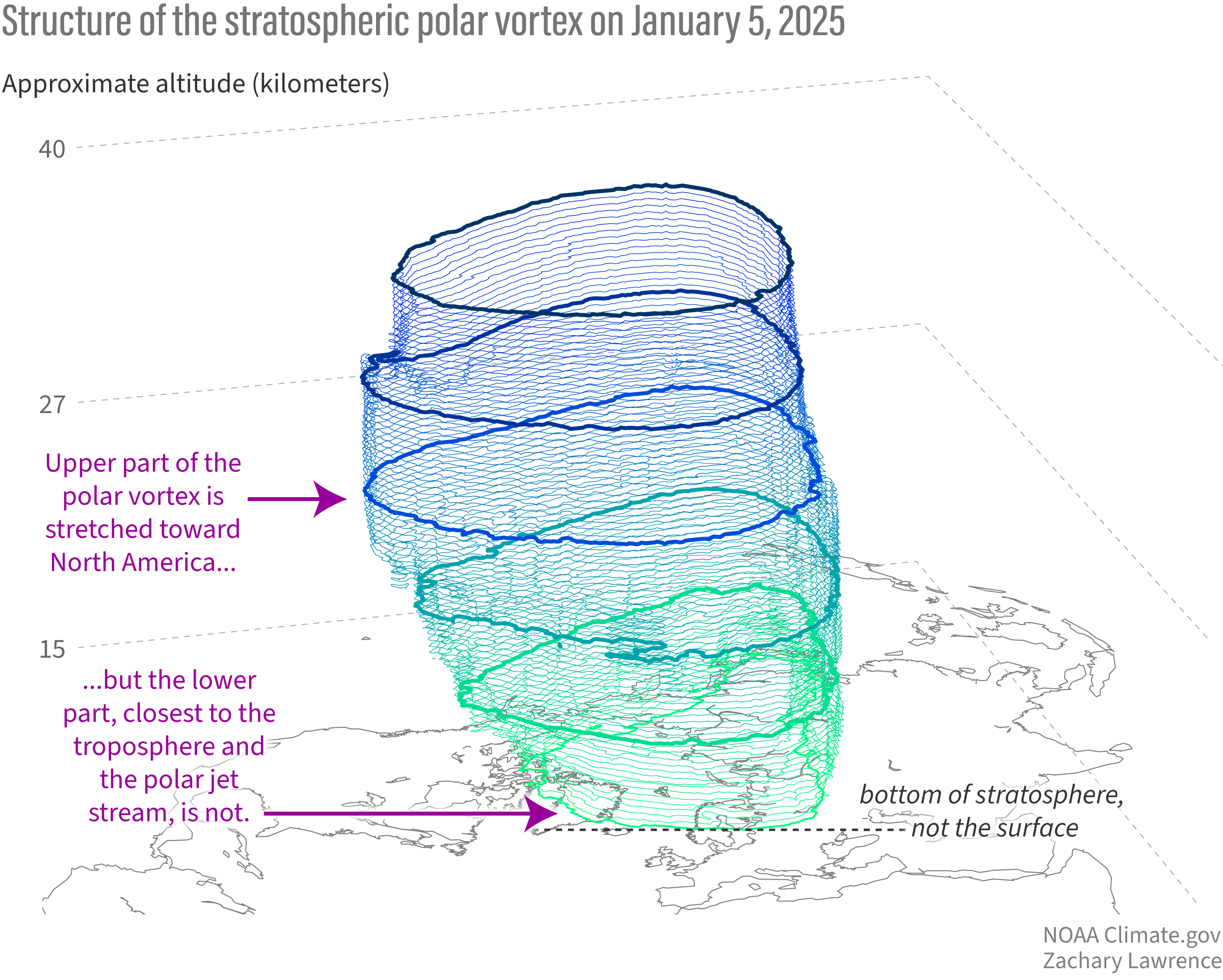
My interpretation of the polar vortex this year.
There's a constant low pressure over the Hudson Bay that has been there for a long time. There's a blocking pattern off the coast of the southeastern US. There's also blocking pattern off the coast of the northwestern US. Add in sudden stratospheric warming in the north pole and this is what we get:

The rule of thumb is: If it's cold in Alaska, it's gonna be warm in Indiana. If it's warn in Alaska, it's gonna be cold in Indiana.
An excellent blog post by Amy Butler and Laura Ciastro on this season's polar vortex.
Sudden Stratospheric Warming is a complex topic. If you are interested in the details, you can read the full blog post here:


Otherwise, here are the most important info-graphics from the post:


Wild temperatures wings coming.
Tuesday night's low will be -2 degrees.
Friday's high temperature will be 43 degrees with rain. Boooo!
Next Tuesday's high will be 10 degrees and the low will be -7 degrees.
Watch out for a big snowstorm during the last week of January, specifically between January 26-29.
The data for February is showing mixed results. Some of the data says warm and some of the data says cold.


I see it on the radar so where is the snow?
The cold dense dry air is evaporating the snow before it hits the ground. Had we not had -2 degrees Thursday morning, it might be snowing now. Nonetheless, that is why you se a full radar screen and no snow outside your window. So all those 4-6 inch totals you saw yesterday are not going to happen. Expect 2-3 inches.


Sometimes the best cure for ice is more snow.
Compacted snow + snowmelt = Ice

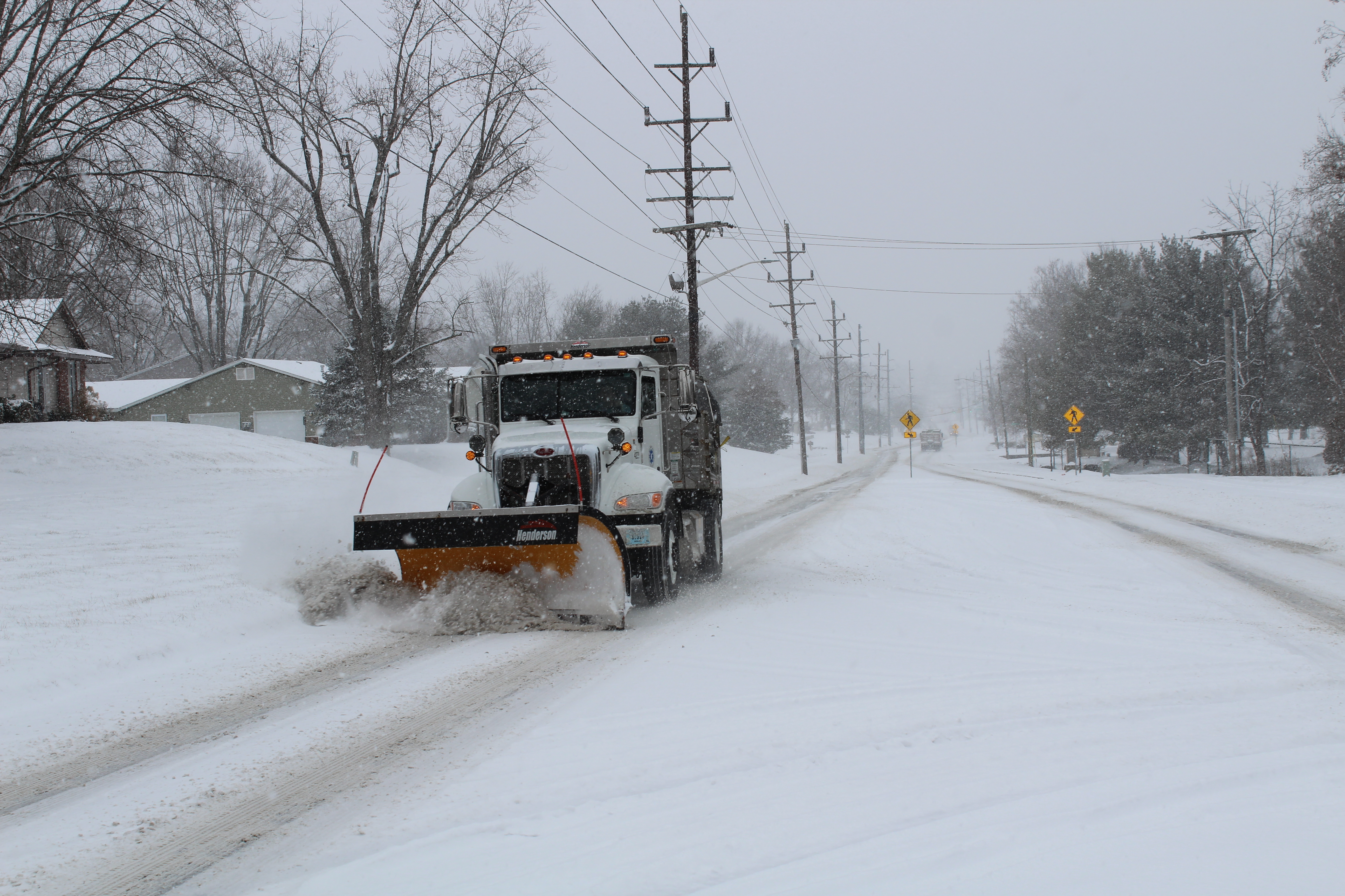
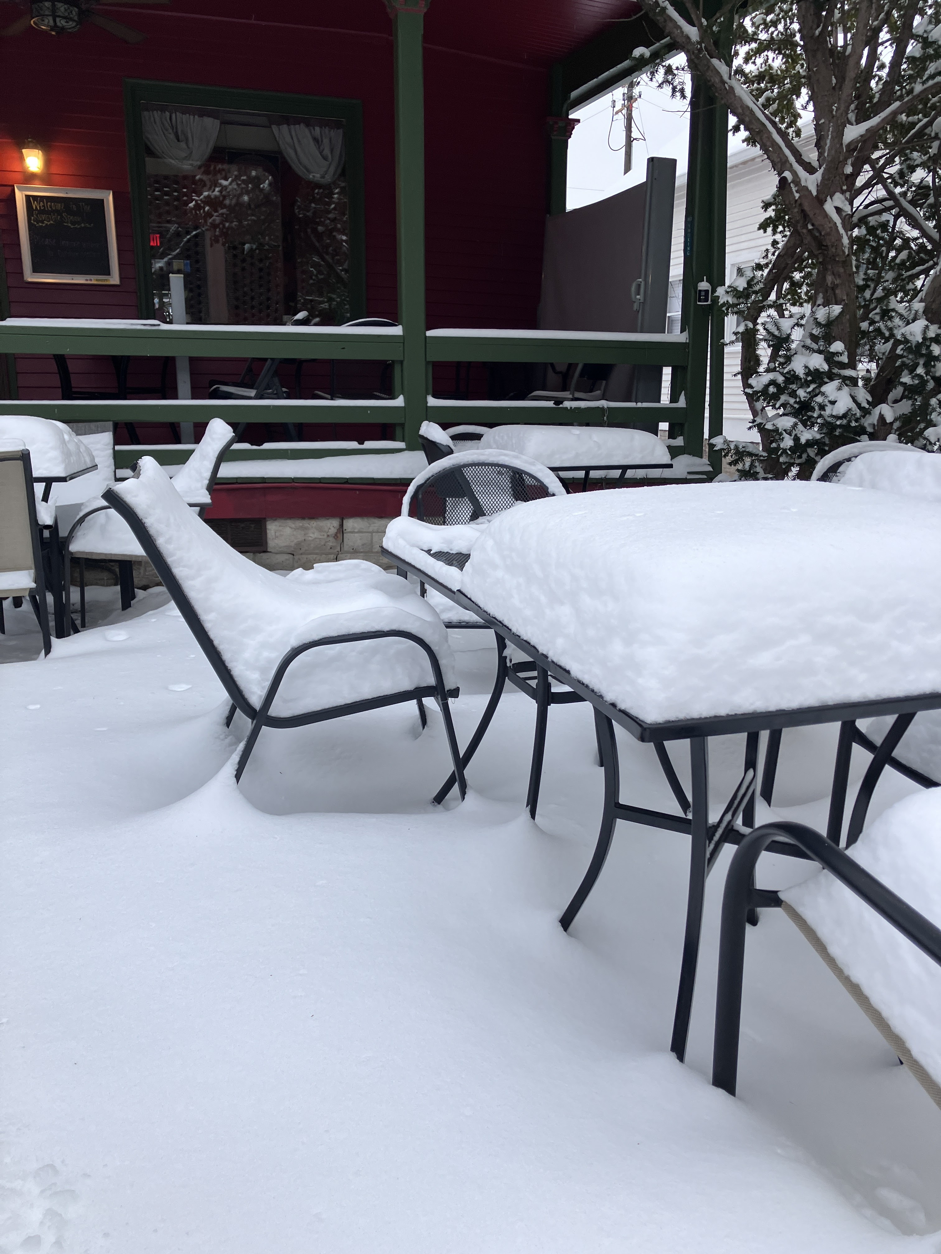
1-5-25 Snowstorm pictures from Bloomington Indiana.
These pictures are from the Sunday (1/5) to Monday (1/6) snowstorm event in Bloomington Indiana.


Snow and Ice for Mexico on January 23 & 24th.
I don't buy it but this is what the GFS model is spitting out.


Snow for Indiana this weekend plus other important updates.
It's going to be very cold tonight. The National Weather Service is forecasting a low temperature of 0 degrees tonight. I think it will get lower than that because of clearing skies. I think the low temperature will be -2 degrees.
The storm system that is bringing big snow and ice to the south will also spread light snow into Indiana due to the merging of two storm systems over eastern Kentucky.
We seem to be in a pattern where we will see a storm system every weekend from now through January 25th.
The polar vortex will relax for three days before it reloads again. We should be above freezing from January 15 -17. After that, it gets cold again.
After that, the polar vortex eases again during the first week of February. There are hints that it will try and make a comeback by Valentines Day.
I don't like it but the National Weather Service has removed the "Windchill Advisory" and replaced it with a "Cold Weather Advisory". I think phrase "cold weather advisory" is fairly relative. I think the phrase "windchill advisory" automatically informs people to bundle up and wear extra layers and not to stay outside too long. That's just me though. In addition to that, the NWS has changed a lot of their definitions. If you would like to see all of them, you see them at:
https://www.weather.gov/lwx/warningsdefined
https://www.weather.gov/lwx/warningsdefined
Here is an example of the new "Cold Weather Advisory"
Cold Weather Advisory
URGENT - WEATHER MESSAGE
National Weather Service Louisville KY
1158 AM EST Wed Jan 8 2025

INZ076>079-083-084-089>092-KYZ023-025-030>037-040>043-049-090515-
/O.NEW.KLMK.CW.Y.0001.250109T0400Z-250109T1500Z/
Orange-Washington IN-Scott IN-Jefferson IN-Dubois-Crawford-Perry-
Harrison IN-Floyd-Clark IN-Hancock-Meade-Jefferson-Oldham-Trimble-
Henry-Shelby-Franklin-Scott KY-Harrison KY-Woodford-Fayette-
Bourbon-Nicholas-Clark KY-
Including the cities of Brandenburg, Corydon, Paris, Salem,
Cynthiana, Lexington, Georgetown, Louisville, New Castle,
Scottsburg, Tell City, Madison, Jasper, Hawesville, Winchester,
Paoli, La Grange, Frankfort, New Albany, Jeffersonville, English,
Bedford, Versailles, Lewisport, Milton, Shelbyville, and Carlisle
1158 AM EST Wed Jan 8 2025 /1058 AM CST Wed Jan 8 2025/

...COLD WEATHER ADVISORY IN EFFECT FROM 11 PM EST /10 PM CST/ THIS
EVENING TO 10 AM EST /9 AM CST/ THURSDAY...

* WHAT...Very cold wind chills or air temperatures as low as 5 below
  zero expected.

* WHERE...Portions of south central Indiana and east central, north
  central, and northwest Kentucky.

* WHEN...From 11 PM EST /10 PM CST/ this evening to 10 AM EST /9 AM
  CST/ Thursday.

* IMPACTS...Frostbite and hypothermia will occur if unprotected skin
  is exposed to these temperatures.

PRECAUTIONARY/PREPAREDNESS ACTIONS...

Use caution while traveling outside. Wear appropriate clothing, a
hat, and gloves.

Keep pets indoors as much as possible. Make sure outdoor animals
have a warm, dry shelter, food, and unfrozen water.
Seven inches of snow in Atlanta Georgia? Big snow in the south for Friday, January 10, 2025
I bet this is exciting for people in the south. Winter Storm Watches are posted for Louisiana, Kentucky, Tennessee, Mississippi, Alabama and Georgia. Atlanta is forecast to get anywhere from 1 to 7 inches of snow. That will be an absolute paralysis of the city. If you have family members in the south, contact them and tell them to prepare now.


Ignore social media posts about the winter storm.
Tune in to the Weather Channel and check out what the National Weather Service is saying. Ignore the socials!


Another snowstorm is possible for next weekend!
Saturday January 11, 2025

The AI forecast (see below) suggests that there will be a pattern flip after this and we will get warmer after January 15th and the colder air shifts to our west while Indiana remains on the border between warm air to the east and cold air to the west. We shall see. But doesn't that high of 52 degrees look nice on January 15th?

Useful links to get you through the snowstorm.
Here are some links that might be helpful:
Delays and Closings from Indiana Public Media (WFIU & WTIU)
https://indianapublicmedia.org/closings/
INDOT basic information
https://www.in.gov/indot/travel-conditions/travel-information/
INDOT traffic camera for Bloomington
https://511in.org/@-86.61691,39.19992,10?show=normalCameras#camera/3888/1546797961
How busy is the traffic on the roads right now?https://www.google.com/maps/@39.150101,-86.5120916,13z/data=!5m1!1e1?entry=ttu&g_ep=EgoyMDI0MTIxMS4wIKXMDSoASAFQAw%3D%3D
IDHS Travel Advisory Map
https://www.in.gov/dhs/travel-advisory-map/
You can also call 511 to get information about road conditions.
If are lonely and feeling depressed and, being shut-in makes you feel even more depressed, call 988 for help. Someone is always available to talk you.
Do not believe stories about a 20+ inch snowfall in southern Indiana.
The farther south you go, the more ice there is mixing in with the snow and this drastically cuts down on the snow totals. Just beware of seeing graphics like these:


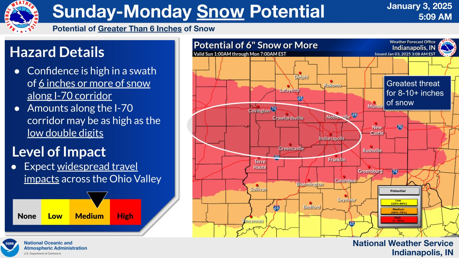
The National Weather Service office in Indianapolis is calling for 5 to 8 inches of snow in our area with an average of about 6 inches. Sure, some places will over-achieve on those totals but not up to 20 inches. Here is the latest from the NWS:


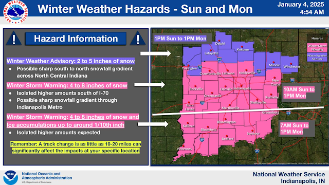
Monroe County Indiana is under a Winter Storm Warning.
We all know this was to be expected. Here is what the National Weather Service is saying:
...WINTER STORM WARNING REMAINS IN EFFECT FROM 7 AM SUNDAY TO 1 PM
EST MONDAY...

* WHAT...Heavy mixed precipitation expected. Total snow and sleet
  accumulations between 5 and 8 inches and ice accumulations around
  a tenth of an inch. Winds gusting as high as 30 to 35 mph.

* WHERE...Portions of central, south central, southeast, and
  southwest Indiana.

* WHEN...From 7 AM Sunday to 1 PM EST Monday.

* IMPACTS...Roads, and especially bridges and overpasses, will
  likely become slick and hazardous. The strong winds and weight of
  snow on tree limbs may down power lines and could cause sporadic
  power outages. Significant ice accumulation on power lines and
  tree limbs may cause widespread and long-lasting power outages.
  Power outages and tree damage are likely due to the ice. Travel
  could be nearly impossible. The hazardous conditions could impact
  the Monday morning commute.

PRECAUTIONARY/PREPAREDNESS ACTIONS...

If you must travel, keep an extra flashlight, food, and water in
your vehicle in case of an emergency. The latest road conditions for
the state you are calling from can be obtained by calling 5 1 1.

Persons should consider delaying all travel. If travel is absolutely
necessary, drive with extreme caution. Consider taking a winter
storm kit along with you, including such items as tire chains,
booster cables, flashlight, shovel, blankets and extra clothing.
Also take water, a first aid kit, and anything else that would help
you survive in case you become stranded.
Bloomington Indiana to be on the dividing line between ice and snow.
Based on the data I've seen and what the National Weather Service office is posting, it looks like Bloomington Indiana will be right on the dividing line. More snow is likely north of Bloomington and more ice mixing with snow is likely south of Bloomington.


Subscribe to:
Comments (Atom)