
Severe storm risk increasing for Saturday.
Parts of Indiana were in the "marginal risk" category and now some parts have been upgraded to the "slight risk"category.

Did you see the green dust on your car this morning?
Yes, it's called pollen. The allergy season has arrived.


Lots of rain coming this weekend.
You'll want to enjoy today and tomorrow because it will rain for most of your weekend. Also, we are under a marginal risk for severe weather on Saturday. Remember that storms can form in the marginal risk areas just as we saw last week.
http://burlsweather.blogspot.com/2018/04/tornado-in-lafayette-indiana.html

http://burlsweather.blogspot.com/2018/04/tornado-in-lafayette-indiana.html

An Interesting factoid.
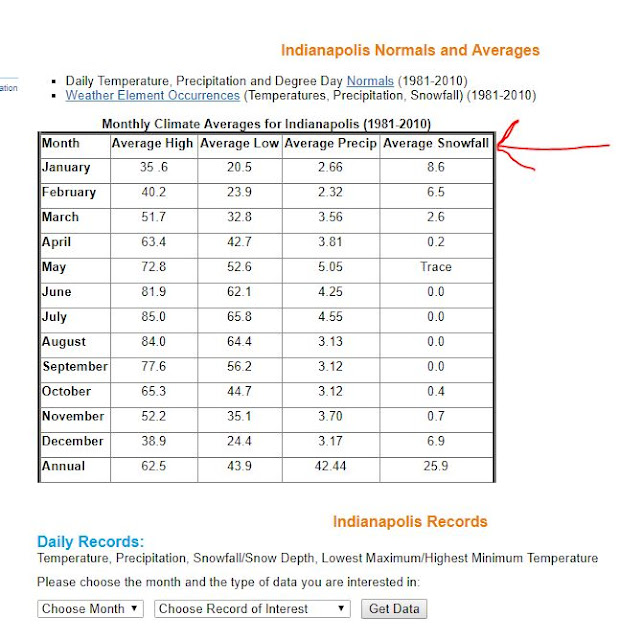
So, I wanted to know if it ever snowed in the month of May in Indiana. Much to my surprise the answer is yes. Sure, it's only a trace amount but is has happened. Here's the data from the National Weather Service.


Don't be fooled by the warm weather this weekend.
I know it feels like April Fool's Day has lasted well beyond its time but don't be fooled by the warm weather forecast for this weekend. Friday will be beautiful with sunny skies and a high of 75 degrees. You couldn't ask for a better day than that. Please get out and enjoy it if you can because old man winter will try to make another comeback next week.
Here is the NWS discusssion:


Here is the NWS discusssion:
.LONG TERM /Friday through Tuesday/...
Issued at 330 AM EDT Tue Apr 10 2018

A large slow moving low pressure system will impact the region
during the coming weekend, necessitating pops through the weekend.
Thunder will also be a threat Friday night and Saturday and will
carry at least a slight chance mention then, potentially ramping
this up as we get closer to the end of the week.

Unfortunately, while the long term will start warm, passage of the
cold front associated with the low will bring another shot of cold
air to the region and temperatures will drop back to well below
normal.
Monday, April 16th and Thursday April 19th look particularly colder than average.


I wouldn't completely rule out seeing a few wet snowflakes after the passage of the cold front Sunday into Monday.
A brief warm spell and back to colder than normal temperatures.
.SHORT TERM.../Tonight through Sunday night/
Issued at 315 AM EDT Fri Apr 6 2018

Models are close enough that the model blend initialization
was accepted for most items.

The surge of colder air aloft and the upper wave will still be
influencing the area at the start of the Tonight period. The NAM and
short term hi-res models focus the best precipitation chances across
the northern and central forecast area early in the period with the
global models farther south.

The NAM has strong frontogenesis across the Interstate 70 corridor
at 00Z, while the RAP and GFS weaker and farther south. If the NAM
ends up being right, this could create some banded heavier
precipitation in the colder air, which would lead to a quick couple
of inches of snow for parts of the I-70 corridor. With most models,
including the SREF mean, keeping the best forcing to the south, will
not buy into the NAM solution at this time. Will have to keep an eye
on how things develop though.

By sticking with the other models, will go high chance to low likely
category PoPs this evening across the south, diminishing overnight.
Precipitation type looks to be a mix of rain and snow south, with
some snow central and north. Went with a dusting for much of the
southern half of the area, with perhaps up to a half an inch some
areas farther south.

Cold high pressure will build in for Saturday and Saturday night,
keeping conditions dry. A low pressure system will move into the
area Sunday afternoon and night, bringing more rain and snow. There
is the potential for 1-2 inches of snow for some areas with this
system. Winter will just not give up.

The model blend looks reasonable for temperatures.

&&

.LONG TERM /Monday through Friday/...
Issued at 250 AM EDT Fri Apr 6 2018

A fairly active period is expected through the long term, with weak
systems bringing chances for precip early in the week and then again
later in the week. Rain chances will increase and temperatures will
warm significantly later in the period as a stronger low pressure
system organizes near the end of the long term, placing the area
solidly in the warm sector. While this may bring a brief period of
the sorely missed warmth from this unsatisfying spring, guidance
beyond the period suggests this will be only temporary.

Blended initialization required relatively few minor tweaks.
Another Ghost Storm!
I don't think I've ever seen this before. The NWS (Louisville office not Indianapolis) issued a Winter Storm Watch for southern Indiana counties yesterday. Today it has been removed /canceled.


Light snow flurries in Bloominton.
Wow! What week. In the past few days it was 50 degrees on Sunday. Then it snowed Sunday night into Monday morning. Yesterday it 69 degrees with rain and storms plus we spent the second half of the day under a Tornado Watch. This morning there's light snow flurries and wind. What a way to open the month of April.
The line of storms has almost passed.
I don't see any tornado warnings happening for Monroe County. There looks like another 45 minutes of moderate to heavy rain, thunder and gusty winds. It could elevate to a severe thunderstorm but that's about it. I'm signing off. The radar looks pretty tame to me.


The line of storms slowed down.
The Tornado Watch that was due to end at 8:00pm has been extended until 1:00am.
Tornado Watch
TORNADO WATCH OUTLINE UPDATE FOR WT 31
NWS STORM PREDICTION CENTER NORMAN OK
730 PM EDT TUE APR 3 2018

TORNADO WATCH 31 IS IN EFFECT UNTIL 100 AM EDT FOR THE
 FOLLOWING LOCATIONS

INC005-011-013-019-021-025-027-029-031-035-037-041-043-047-055-
057-059-061-063-065-071-077-079-081-083-093-095-097-101-105-109-
115-117-119-123-133-135-137-139-143-145-153-155-159-161-175-177-
040500-
/O.NEW.KWNS.TO.A.0031.180403T2330Z-180404T0500Z/

IN
.    INDIANA COUNTIES INCLUDED ARE

BARTHOLOMEW          BOONE               BROWN
CLARK                CLAY                CRAWFORD
DAVIESS              DEARBORN            DECATUR
DELAWARE             DUBOIS              FAYETTE
FLOYD                FRANKLIN            GREENE
HAMILTON             HANCOCK             HARRISON
HENDRICKS            HENRY               JACKSON
JEFFERSON            JENNINGS            JOHNSON
KNOX                 LAWRENCE            MADISON
MARION               MARTIN              MONROE
MORGAN               OHIO                ORANGE
OWEN                 PERRY               PUTNAM
RANDOLPH             RIPLEY              RUSH
SCOTT                SHELBY              SULLIVAN
SWITZERLAND          TIPTON              UNION
WASHINGTON           WAYNE
$$
Subscribe to:
Posts (Atom)