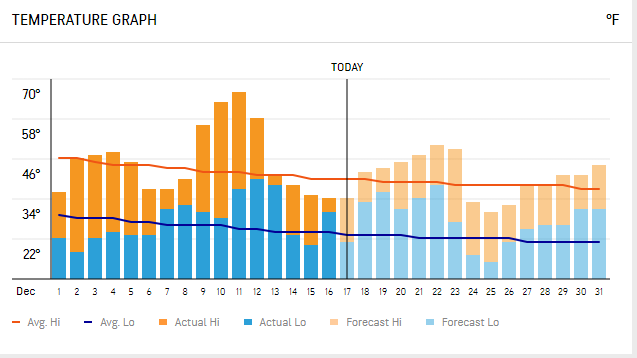
Temperatures are going to go from one extreme to the other. It looks like the cold air will mostly likely be sustaining from from January 2nd to the middle of January.
Wednesday 12-23.
Friday 12-25.
Thursday 12-31.
Saturday 1-2.
Notice the rise-and-fall pattern of temperatures relative to average in the charts below.
There's a chance we might see a White Christmas this year. The GFS and the Canadian models say yes.
For #BOTS fans we are looking at two small (2-inch) snow storms between now and New Year's Eve.
Here's what the National Weather Service in Indianapolis says:
.LONG TERM /Sunday through Wednesday/...
Issued at 359 AM EST Thu Dec 17 2020

The weather next week will be a roller coaster. Starting
off with above normal temperatures and ending with a blast of arctic
air. Not to get too ahead of ourselves, but a white Christmas would
not be impossible either (and by white Christmas, we mean some snow
may fall within 48 hours of Christmas).

An upper wave will be making its way through the region at the
beginning of the period. Central Indiana is expected to stay dry,
with precipitation staying to the north of the area where better
forcing and moisture are. Ridging aloft will then move in, with
surface high pressure expanding into the area. This will then place
us under SW flow on the backside of the high which will bump
temperatures to above normal, reaching the mid 40s to near 50
degrees from Monday to Wednesday.

A large amplitude trough will impact the region towards the end of
the period which will bring precipitation ahead of it and cold
arctic air behind it. As this system is in the day 6 to 8 timeframe
there are a lot of uncertainties and models vary on their solutions.
For now, the timing of the precip looks to be sometime between
Wednesday night and Thursday night, starting out as rain and
transitioning to snow before the system exits to the east. The
question of whether or not portions of central Indiana will get a
white Christmas (again, we`re being over zealous with that phrase at
this time) lies with how the timing of the precipitation will align
with drastically colder air behind the front. There is a decent
consensus that the low temperatures on Christmas morning will be in
the upper teens with wind chills in the single digits. Much remains
to be seen, but we are saying there is a chance!


No comments:
Post a Comment