It could be a rainy and / or/ stormy fourth of July.
If you still need help in Bloomington, Indiana...
Believe it or not, there are still 7,000 people in Bloomington without electricity and tomorrow's high will be 90 degrees. Here are some community alerts I received today:

Residents in need without access to tap water can drive in and pick up 2 cases of water at the Sherwood Oaks Christian Church, 2700 E. Rogers Rd. Hours of distribution: Thursday June 27, open until 7 PM and Friday June 28 from 2 PM to 7 PM.
A shelter is open at The Salvation Army, 111 N Rogers St., for those who are in need of shelter after the June 25 storm.
Pictures from yesterday's 6/25/2024 Supercell storm in Bloomington, Indiana


If you would like to see more pictures, click on the link below:
What happened in Bloomington yesterday was called supercell thunderstorm.
Many are asking why we didn't hear the tornado sirens yesterday. Technically, there was no tornado. Supercells are 'capable' of producing tornadoes but that didn't happen yesterday. Yesterday's damage was due to high winds. Terre Haute and Bloomington took the brunt of the storm and sustained the most damages. There a 60% chance of thunderstorms today and tonight but they are not expected to be severe.
From the Indianapolis Star:
From 45 degrees to 95 degrees in 6 days!
I hope you enjoyed Monday's fall-like weather. The temperatures are going to warm up quickly. Expect a high of 90 degrees tomorrow and 95 by Sunday. The long range forecast shows high temperatures continuing to stay in the upper 80's to low 90's through July 4th.
The good news is that the Summer Solstice is on Thursday, June 20, 2024 at 4:50PM. That is the day with longest amount of sunlight this year. After that, the days start getting shorter again as we approach fall and then winter. #BOTS!
Several southern Indiana counties are under an "Air Quality Alert" so beware of that if traveling to the southern part of the state.
Here is what the NWS is saying about the weather in Indiana:
Area Forecast Discussion
National Weather Service Indianapolis IN
124 PM EDT Wed Jun 12 2024

.KEY MESSAGES...

- Warming trend begins today with highs in the mid 80s, highs near
  90 for Thursday

- Thunderstorms, a few strong or severe, are possible Thursday night

- Hot and humid starting Sunday

&&

.FORECAST UPDATE...
Issued at 956 AM EDT Wed Jun 12 2024

The forecast remains in good shape with only minor adjustments
needed. Expect quiet weather conditions today as surface high
pressure remains in control. There is a low (10%) chance for
an isolated light shower this morning over far NW portions of
central Indiana over the next hour or two due to an approaching
weak frontal boundary. This weak boundary will stall near NW
Indiana which could allow for a few additional light diurnal
showers to develop towards this evening.

Confidence in precipitation is very low given weak forcing and
subtle moisture. Will hold off on any mentionable POPs for later
today, but slight POPs may need to be added in future updates.
Increasing southwesterly flow combined with mostly sunny skies
will warm temperatures into the 80s this afternoon.

&&

.SHORT TERM (Today and tonight)...
Issued at 305 AM EDT Wed Jun 12 2024

Surface analysis shows high pressure directly overhead. Winds
have gone largely calm, and large-scale subsidence along with a
mainly dry column has been eroding cloud cover through the evening.
Additionally, the system responsible for the cloud cover is pulling
away to our northeast. As such, continued clearing and excellent
radiational cooling conditions should prevail through sunrise.
Despite this, temps are running about 10 degrees above where they
were last night since the core of colder air aloft is now to our
east.

With high pressure largely in control, we can expect quiet weather
for the most part. Only a few high clouds may pass by at times and
perhaps some diurnal cumulus may develop by the afternoon.
Otherwise, surface winds become southwesterly as the high shifts
eastward. A tightening surface pressure gradient looks to develop
just to our northwest as a system impinges on the departing high.
This may allow for some higher speeds and occasional gusts from
about Lafayette northwestward. Winds still remain on the lighter
side, regardless...with highest gusts hitting 20mph at most. Warmer
winds from the southwest lead to even higher temperatures today with
most places climbing into the middle 80s.

High-res guidance is hinting at a weak convergent zone developing
across northern Indiana late this afternoon. Additionally, they show
a plume of higher dew points advecting northeastward along this
boundary. Some members show dew points climbing into the lower 60s
across northwestern portions of the area by evening (dew points in
the 50s elsewhere). Model soundings show a dry column above 850mb,
but enough near-surface moisture for limited instability along this
boundary. Interestingly enough, multiple HREF members hint at
isolated showers developing from around Lafayette northward around
22z. Probability of occurrence seems low (10-15 percent), due to
limited forcing and instability...and if any shower develops is
should be fairly shallow and short-lived.

By tonight, expect any showers that manage to form to diminish
quickly after sunset. Diminishing surface winds should retain a
southwesterly component...but may go light and variable south and
east of I-70. High clouds may pass through at times as debris cirrus
from upstream convection drifts southeastward. Warmer lows more
typical of June are expected with values dropping into the low 60s,
with a few areas of upper 50s across our far southeast.

&&

.LONG TERM (Thursday through Tuesday)...
Issued at 305 AM EDT Wed Jun 12 2024

Thursday Through Friday night.

The northwest flow regime will continue aloft through Friday night
which will keep it mostly dry. However, models hint at the potential
for an MCS to move across central Indiana Thursday night. Even if
one doesn`t develop and move through, a cold front will be diving
southeast across the area Thursday night and the combo of lift
associated with that along with models supporting moderate
instability with CAPEs to over 1500 J/kg supports 30+ chance PoPs
Thursday night.

If an MCS would develop, Corfidi vectors favor a southeast moving
complex. Weak surface pressure gradient suggests low level inflow
into the system will be minimal, however 50 knot deep shear and
veering with height to go with the moderate instability supports the
Spc Day2 Marginal and Slight Risks over northern and western parts
of central Indiana with damaging winds and possibly large hail the
main threats.It is too early to diagnose mesoscale details,
including cold pool/shear balance. So, confidence is low on timing
and coverage of convection.

As the surface ridge aligns SW-NE along and south of the Ohio River,
temperatures will gradually warm to near 90 degrees by Thursday.
Meanwhile, potential cold front passage looks like it will result in
Friday being not quite as warm with timing considerations key.
Confidence is trending on the not as warm side.

Saturday Through Wednesday.

The main concern later in the weekend and next week will be the heat
and humidity as an upper ridge builds overhead and then shifts east.
At the same time, southerly low level flow will return to the Ohio
Valley and Great Lakes. The return flow around the high is likely to
result in dew points increasing to the upper 60s and perhaps lower
70s by Monday and with little cloud cover and continued southerly
inflow under the influence of the ridge, temperatures could easily
reach the lower 90s if not Sunday then Monday. With the increased
moisture and instability, can not rule out isolated mainly diurnal
pop ups. Models and ensembles are having problems resolving
northeastward moving upper waves around the back side of the ridge
but there is enough there to at least suggest a few storms can not
be ruled out next week.

This time period will need to the be looked at for potential future
headlines. For now, will broadbrush it in the HWO and keep a weather
story graphic going.
There seems to be three distinct categories setting up.
But as always, things are subject to change.


Here we go! A Tornado Watch has been issued for most of Indiana until 9:00PM
It makes sense. The second line of storms is forming in Illinois.

Tornado Watch
TORNADO WATCH OUTLINE UPDATE FOR WT 195
NWS STORM PREDICTION CENTER NORMAN OK
225 PM EDT TUE MAY 7 2024

TORNADO WATCH 195 IS IN EFFECT UNTIL 900 PM EDT FOR THE
 FOLLOWING LOCATIONS

INC005-007-011-013-015-017-021-023-027-039-045-049-053-055-057-
059-063-067-069-071-073-081-083-085-087-089-091-093-095-097-099-
101-103-105-107-109-111-113-119-121-127-131-133-141-145-149-153-
157-159-165-167-169-171-181-183-080100-
/O.NEW.KWNS.TO.A.0195.240507T1825Z-240508T0100Z/

IN
.    INDIANA COUNTIES INCLUDED ARE

BARTHOLOMEW          BENTON              BOONE
BROWN                CARROLL             CASS
CLAY                 CLINTON             DAVIESS
ELKHART              FOUNTAIN            FULTON
GRANT                GREENE              HAMILTON
HANCOCK              HENDRICKS           HOWARD
HUNTINGTON           JACKSON             JASPER
JOHNSON              KNOX                KOSCIUSKO
LAGRANGE             LAKE                LAWRENCE
LA PORTE             MADISON             MARION
MARSHALL             MARTIN              MIAMI
MONROE               MONTGOMERY          MORGAN
NEWTON               NOBLE               OWEN
PARKE                PORTER              PULASKI
PUTNAM               SHELBY              ST. JOSEPH
STARKE               SULLIVAN            TIPPECANOE
TIPTON               VERMILLION          VIGO
WABASH               WARREN              WHITE
WHITLEY
Be alert for severe weather today and for the next 48 hours. (5/7 - 5/8)
If you have a weather radio, make sure it's on and has fresh batteries. If you don't have a weather radio, you should buy one along with some batteries. Today and tomorrow should be rough and then it's all over by Thursday. Friday will be sunny with a high of 64 and the low will be 48. Isn't that nice?
The Plains States got hit really hard last night. One person is dead and there's a lot of destruction.
For us here in Indiana, a large bow echo is forming right at the Illinois-Indiana border.

I expect the National Weather Service to put out a severe thunderstorm watch at some point and maybe even a tornado watch. Here what they are saying for now:
Area Forecast Discussion
National Weather Service Indianapolis IN
618 AM EDT Tue May 7 2024

.KEY MESSAGES...

- Severe storms expected today, especially during the afternoon
  and evening. All forms of severe hazards are possible.

- Additional severe storms are possible Wednesday afternoon and
  evening. All forms of severe hazards are again possible.

- Heavy rain is possible at times through Wednesday night. Localized
  flooding will also be possible.

- More chances for thunderstorms mainly Thursday and Saturday.

- Normal to slightly below normal temperatures from Thursday
  into early next week.

&&

.FORECAST UPDATE...
Issued at 617 AM EDT Tue May 7 2024

With the main line of convection still well to the west over west
central Illinois, slowed down PoPs a bit. The ETA of the line into
the Wabash Valley has been pushed back to 13z per AWIPS distance
speed tool. Expect the line to weaken substantially with little to
no instability to work with per LAPS data.

&&

.SHORT TERM (Today and tonight)...
Issued at 245 AM EDT Tue May 7 2024

Tuesday Rd #1 | Strong but Mostly Sub-Severe | Between 9AM and 12PM

An ongoing MCS over MO will progress eastward overnight, propelled
by a strong LLJ. As this reaches the Ohio Valley this morning, the
LLJ will begin to wain, remaining stronger further west. Still,
sufficient 0-3km CAPE between 100-150 J/kg, and a sustained cold
pool should be enough to keep the MCS ongoing despite weaker LL
dynamics. The expectation is for this MCS to be over Indiana
between 9AM and 12PM.

Atmospheric disorganization and a lull in thermodynamic availability
will be the main mitigating factors for severe convection within
this initial round. An elongated low to the north will keep deep
layer shear elevated over the northern half of central Indiana, but
mid level lapse rates and theta-e advection ahead of the MCS will be
much weaker. The opposite will be true for the southern half of
central Indiana (Elevated Instability, but Weak Shear).

This should cause the storms over northern central Indiana to become
more shear dominant, with convection outrunning the UDCZ. For this
reason, the northern section of the line may briefly be near severe
criteria as it nears/enters Indiana, but should quickly weaken as it
progresses eastward.

The southern half of the storm then becomes the greater concern
depending on how quickly the cold pool moves eastward. Its possible
the cold pool becomes dominant on the southern half, and the main
concern then shifts towards initiation along the outflow boundary.
However, if balance does remain, there is high enough 0-3km CAPE,
and theta-e ingestion for potentially severe wind gusts along the
UDCZ for this first round.

Tuesday Rd #2 | Scattered Severe Storms | Between 3PM and 10PM

Even though this is round 2 of convection for the day, the storm
mode and overall hazards will likely not be the same over the entire
7 hour threat period. For that reason, I am going to split this
portion of the discussion into 2a (3P-7P) and 2b (6P-10P).

Round 2a (3P-7P): The remnants of the morning convective line will
be moving away by early afternoon with a capped lower level for
portions of the late morning and early afternoon. Any cap that does
form will quickly erode as rapid theta-e advection pushes a warm,
moist layer over central Indiana this afternoon. Broad diffluence of
the mid/upper level jet streaks along with this rapidly
destabilizing atmosphere should lead to scattered CI over central
Indiana around mid-afternoon.

Early on, multicellular clusters will be the more common storm mode
as overall parameter spacing remains moderated by sufficient, but
weak 800-700mb winds, and weak anvil level flow. Current
expectations for this initial time period are for 0-1 SRH to be
around 100, with CAPE beginning around 1500 J/kg. Effective shear
will still be plenty strong for updraft organization within
multicells, and an isolated wind and hail threat is likely. Poor
precip dispersion aloft within weak anvil level flow, may lead to
precip loading in the updraft, creating more sub-severe and melting
hail, but confidence is not high in this solution given robust
effective bulk shear.

Round 2b (6P-10P): The second half of this round looks to be the
most potent portion of the entire day. A pressure trough will begin
to develop across central Indiana late this afternoon into the
evening providing another source of lift and convective
organization. Shear vectors along this pressure trough remain
orthogonal keeping the storm mode mostly discrete. During this time
period, mid level lapse rates ramp up even further, pushing SBCAPE
values near 3000 J/kg. This along with better anvil level flow, and
a strengthening LLJ will likely lead to the formation of supercells.
This time period will be most concerning for areas along and east of
the I-69 corridor including the cities of Muncie, Indianapolis,
Bloomington, Shelbyville, Columbus, Rushville, Winchester, and
Seymour.

With the expectation of supercells during this time period, all
severe hazards are on the table. Strong 0-1km lapse rates, 0-1km
shear and low LCLs also intensify the tornado threat for this time
period, including the potential for a few strong tornadoes (EF2+).
Giant hail (2.5"+) will also be possible within strong updrafts of
supercells.

&&

.LONG TERM (Wednesday through Monday)...
Issued at 245 AM EDT Tue May 7 2024

Wednesday and Wednesday night...

A severe weather outbreak followed by heavy rain and flooding are
possible Wednesday afternoon and night as a surface low heads
northeast towards central Indiana in the fast southwest flow aloft
around the base of the High Plains upper low. This will allow a warm
front to lift northeast from southern Indiana to near the I-74
corridor by late afternoon. By Thursday morning, the associated
surface low will be somewhere near Muncie with a cold front sweeping
through from the west. Out ahead of the cold front and in the warm
sector to the south of the northeastward moving warm front, the
atmosphere will destabilize during the afternoon with CAPEs in
excess of 1000 J/kg. The combination of the instability, strong mid
level shear in excess of 50 knots and the synoptic forcing will
likely lead to rapid thunderstorm development during the afternoon
with all modes of severe storms possible. Model soundings are
afternoon curved hodographs with 0-3 km SRH near 200 and 0-1 km SRH
slightly over 100.

The biggest caveat to severe weather potential across central
Indiana will be how far northeast the warm front gets during the
afternoon and if discrete cells can form ahead of a likely MCS
approaching from the southwest. If the front doesn`t it make it as
far northeast, and the 00z runs are hinting at this scenario, severe
weather will likely be limited to our southwestern counties. This
has prompted a further southwest shift in the SPC Day2 severe
outlook, which has the Enhanced Risk south of Terre Haute and
Greensburg and the Slight Risk only as far north as Cicero and
Anderson. FWIW, CAMs favor the bulk of the MCS to move south of I-74
with little to no discrete cells ahead of it. Still, with
uncertainty, will continue with 80+ percent PoPs over all central
Indiana Wednesday night with 50 percent PoPs Wed afternoon
over southwestern counties tapering to 20 percent northeast.

By nightfall, the focus will shift more towards heavy rain and
flooding as PWATS increase to 1.5 inches or higher which is the max
moving average for this time of year. In addition, coupled jet
structure from jet maxes over the Great Lakes and southern states,
could enhance rainfall totals. DESI suggests an inch or more 24 hour
QPF is possible over south central Indiana and this looks to be on
the low side. Will make mention of heavy rain and flooding potential
in the HWO and in web site and social media graphics.

Thursday night through Tuesday...

A pair of upper waves in northwest flow aloft will bring decent
chances for convection to the area Thursday and again Saturday.
Otherwise, signal lacking for anything other than low chances for
convection for the rest of the weekend due to general troughy flow
aloft. Meanwhile, models are hinting at an approaching upper ridge
early next week which would tend to bring dry weather.

Temperatures look to be more on the cool side than recently with
normal or slightly below normal afternoon highs in the 60s and 70s.
NWS: A Major Severe Weather Outbreak is Forecast Today and/or Tonight
Please read the National Weather Service's Public Severe Weather Outlook.
https://www.spc.noaa.gov/products/outlook/pwo.html
See also The Storm Prediction Center:
Prepare for severe storms in Indiana and the entire central USA!
Indiana will see a chance of strong to severe storms on both Tuesday and Wednesday. If you have family living in Kentucky or Oklahoma, be sure and give them a call to warn them. Tornadoes are likely in those states and they should probably get a hotel in another state until the storms pass.
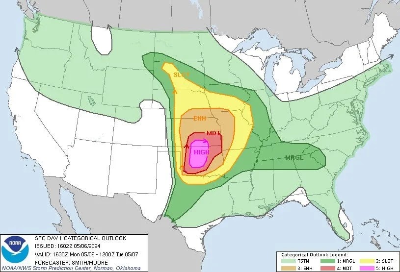


Here is what the National Weather Service is thinking about Indiana:
LONG TERM (Tuesday Night through Monday)...
Issued at 305 PM EDT Mon May 6 2024

Late Tuesday night through Wednesday night...

A break in convection is expected to start late Tuesday night, with
even weak ridging building into central Indiana from the subtropical
surface high pressure to our southeast.  Despite clearing skies,
lighter southwesterly breezes will hold dewpoints in the upper
50s...resulting in low temperatures around 60F across the region.

Wednesday will bring another favorable set-up for convection and
perhaps widespread severe weather with a warm frontal type boundary
likely slowly advancing northward near our southern counties ahead
of a strengthening surface low slowly approaching over the Middle
Mississippi Valley.  Much of the day Wednesday may be the quiet
before the storm as the narrow ridging between the two systems
continues to cross the CWA...albeit eventually self-destructive with
the bright skies bringing low 80s and light southerly winds holding
dewpoints in the 55-65F range.  Resultant CAPE by 21Z should range
from 1000-3000 J/kg from north-south...including moderately strong 7-
8 deg/km lapse rates over most of the area.  Widespread 40-55 kt 0-6
km shear will also support arriving/developing convection.

So far appears most likely storm pattern will be a mesoscale
convective system initiating in the afternoon somewhere in the
central/eastern Illinois region...before tracking eastward into
Indiana during the late day/early evening hours.  This would likely
transition into more of a heavy rain/flooding threat later in the
evening and into overnight hours, especially south of I-70 amid the
system`s warm sector`s anomalous precipitable water values
approaching 2.00 inches.  While the environment would support
discrete cells ahead of a later MCS arrival...organized severe
weather`s location would be dependent on warm frontal position, with
timing likely determined by where/when storms begin to fire to our
west.

All severe hazards are on the table for PM hours Wednesday with
damaging winds and large hail the greatest threats during the
afternoon/evening...and flooding the greatest concern for the
evening/overnight.  Although it is only early May, the set-up and
potential are perhaps more indicative of a June pattern with the
synoptic set-up able to effortlessly fuel ample deep moisture into
central and especially southern Indiana.  Rain chances will drop
from west to east late Wednesday night as the supporting surface low
crosses the state.  Total 24-hour rainfall potential for Wed-Wed
night will be 1.00-2.50 inches along/south of the I-70 corridor,
with less than 1.00 inch expected for most locations north of I-70.

Temperatures will be above normal amid the S/SW flow and overall
warm sector of the passing/approaching systems.  Expect low 80s
ahead of convection Wednesday...while lows Wednesday night amid
decreasing chances of rain ranging from the upper 50s near Lafayette
to the mid 60s south of the I-70 corridor.


Thursday through Monday...

The last five days of the long term will then trend to at least a
couple northern stream, positively-tilted short waves cycling from
the northern Plains into the Midwest.  Not the greatest certainty
with this pattern, with some guidance members originally hinting at
the second wave plunging and inducing a strong baroclinic
circulation near the Ohio Valley around the Sunday/Monday timeframe
...however, latest data now suggests amplification will be more
modest, which should keep the pattern more progressive over the
region thru the end of the long term.

This should translate to near to slightly below temperatures amid
west-northwesterly breezes.  Thursday will be marked by robust to
gusty breezes as the gradient from the combination of departing low
pressure and the passage mid-level supporting vort.  The 5-day
period will include several chances for at least stray showers under
the troughy flow...with more organized showers expected both
Thursday and Saturday per corresponding short waves.  Widespread
and/or heavy rainfall could be possible early next week should the
weekend wave plunge and phase, although currently low chances in
this set-up coming to fruition.  The normal max/min at Indianapolis
through the long term is 72/52.
Subscribe to:
Posts (Atom)