It's 56 degrees with mostly sunny skies! It is absolutely beautiful outside. I would say get out and enjoy it except you should avoid the downtown area. There is a basketball game today at 2:15pm as the Hoosiers will host the Golden Gophers. There's traffic everywhere and no place to park so beware. Rain kicks in Sunday night. Thunderstorms roll in for Tuesday and a 30% chance of snow showers for Wednesday. Nothing interesting showing up just yet. BOTS fans be patient. By February 15 or so, we could go into a colder and snowier patter but that is 15 days away. We'll see what the indices say.
Friday 1/29
February is nearly here. You can read my previous post on my thoughts for February. 60 degrees Sunday and possible Tuesday. Rain chances throughout all those days.
This is a good example.
There was a time when you had to pay for subscriptions to get model guidance data but now lots of people have access to them for free. For those grabbing the free ones, this is a good example of why you should not trust models 15 days out.
Possible Storm Tracks for February
I mentioned in an earlier post that there were some strange things going on. One was a possible Bering Sea storm like we've had in previous years. Another was a low pressure in the gulf or off the east coast. Here's my map for possible storm tracks for February.
Don't believe, don't believe the hype.
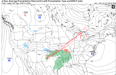
Or so says Public Enemy. It could easily bee all rain this far out if you keep in mind a flip-flop in temperatures in February. Timing, cold air supply and track are key. Also, these are GFS deterministic models, not ensemble models for February 10 & 11.
Nice couple of days coming up.
Thursday, Friday and Saturday look clear and sunny with high temps at 42F, 41F and 54F respectively. All eyes are on the Ground Hog's Day storm that could bring us rain and thunderstorms. We'll know more about that on Sunday. Some people are focusing on a *possible* winter weather event that is three and a half weeks out. There's no way to predict anything that far out with any kind of respectable certainty. So, just for fun, these are the images that people are looking at:
It could be rain, it could be snow or it could be nothing. We will have to wait and see.
It could be rain, it could be snow or it could be nothing. We will have to wait and see.
The pattern is the same.
The pattern we are in looks the same as the late December 2015 to January 15, 2015. Severe weather and thunderstorms usually precede a cold outbreak. Thunderstorms are possible next Tuesday followed by colder air and then warmer air and then colder air. You can follow the NWS discussion board @
http://forecast.weather.gov/product.php?site=IND&issuedby=IND&product=AFD&format=CI&version=1&glossary=1
http://forecast.weather.gov/product.php?site=IND&issuedby=IND&product=AFD&format=CI&version=1&glossary=1
Update 1/27/16 @12:15PM
Okay, I'm going to issue another warning. Be careful about the pictures and graphics you see on social media sites. February might oscillate between warm shots and cold shots and *if*, and I mean *if* the warm and cold air phase at the right moment in the right location, it is possible to get accumulating snow, or, it's possible to get heavy rain. Anything is possible. The images being shown on social media are for the February 5th to the 11th time frame. A lot can change between now and then. I trust a forecast for about 3 days.
1/26/16 1:23pm
It cloudy in Bloomington with a temperature of 33F. The barometric pressure is 30.13in. Expect a warming trend this week. We could see temperatures in the 50's by Saturday. There are some very strange things going on in the weather that will make February difficult to forecast. I'm seeing strong punches of cold air coming in followed by warm ups. The question is how strong and lasting are the cold shots and how strong and lasting are the warm ups. This will be a repeating pattern throughout February. Weather dot com has come out with a forecast for February as "Much above average" for our area.
That would leave us at below average for snow this winter. I know they are the big media guys an everyone trusts them but I would like to get back to the "very strange things" I mentioned earlier.
1. One and possibly two more low pressure systems show up on the east coast in long range data. It's doesn't not mean that there will be another storm like Jonas, but the model guidance flirts with the idea.
2. In 2004, 2005, 2011, 2014 & 2015 we saw very large Bering Sea storms. Another one of those is being hinted at in the model. One of deepens and weakens so rapidly that it goes in retrograde motion (from right to left as most storm travel from west to east).
3. A gulf low pops up and quickly disappears.
On the other hand, the indicies show a pattern change to colder air around mid February. I'm seeing:
-AO, -NAO and slightly +PNA.
At this time I'm sticking with alternating pushes of warm and cold air throughout February.
Cold punch, warm punch, lock, load & repeat.
That would leave us at below average for snow this winter. I know they are the big media guys an everyone trusts them but I would like to get back to the "very strange things" I mentioned earlier.
1. One and possibly two more low pressure systems show up on the east coast in long range data. It's doesn't not mean that there will be another storm like Jonas, but the model guidance flirts with the idea.
2. In 2004, 2005, 2011, 2014 & 2015 we saw very large Bering Sea storms. Another one of those is being hinted at in the model. One of deepens and weakens so rapidly that it goes in retrograde motion (from right to left as most storm travel from west to east).
3. A gulf low pops up and quickly disappears.
On the other hand, the indicies show a pattern change to colder air around mid February. I'm seeing:
-AO, -NAO and slightly +PNA.
At this time I'm sticking with alternating pushes of warm and cold air throughout February.
Winter is not over!
Yes, there is a warm up coming but that does not mean all is lost for more snow in Indiana. The MJO still has a chance to move into the 7-8 region by mid to late February through March 1. All is not lost. Keep in mind that we are behind on snow totals for the Bloomington area. All is takes is 1 or 2 good ones to put us on average or even above average for the year. Hang in there #BOTS! fans.
Are you interested in the weather too?
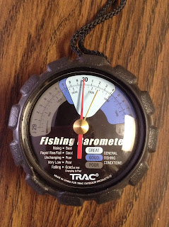
If so, the first thing you should purchase is a barometer. With a high pressure of nearly 30.00in, I knew that snow was unlikely yesterday.
How many cold canking amps do you have left?
Cold temperatures are hard on car batteries. Don't forget to check your car battery and replace it every five years. Some batteries display the number of "Cold cranking amps" on the case.
Nice sunnday day!
I think there should have been an advisory posted for yesterday's winds. I nearly lost my flat cap. Today is much better. The current temperature is 30 degrees. When temperatures have been in the single digits and teens, 30 degrees feels nice. People are out and about.
1/22/16 Update 2 @1:15pm
There are some AMAZING pictures of the snow on social media coming form the Kentucky area. This could rival the Blizzard of '78.
1/22/16 1:00pm Update.
No snow for Bloomington. Low pressure just can't move a high pressure. Slight warming trend next week. Temperatures rise into the 40's by February 1. Don't worry #BOTS fans, winter is not over.
I look at a lot of weather websites.
Some of these you probably have heard of but maybe not others. Enjoy my personal weather link farm.
http://www.meteoearth.com/
http://earth.nullschool.net/
http://justin.wiscwx.com/
http://indywx.com/
http://www.
http://www.stormvistawxmodels.com/
https://twitter.com/hashtag/inwx?lang=en
http://collaboration.cmc.ec.gc.ca/cmc/cmdn/pcpn_type/pcpn_type_gem_reg.html
http://www.meteoearth.com/
http://earth.nullschool.net/
http://justin.wiscwx.com/
http://indywx.com/
http://www.
http://www.stormvistawxmodels.com/
https://twitter.com/hashtag/inwx?lang=en
http://collaboration.cmc.ec.gc.ca/cmc/cmdn/pcpn_type/pcpn_type_gem_reg.html
http://www.weatherstreet.com/
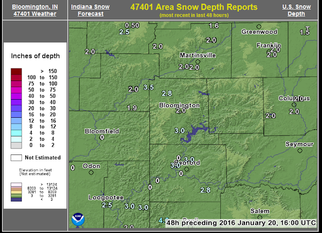
http://www.weatherstreet.com/city_snow_depth/47401-Bloomington-IN-snow-depth.htm
http://www.weatherstreet.com/city_snow_depth/47401-Bloomington-IN-snow-depth.htm
https://twitter.com/weatherbell?ref_src=twsrc^google|twcamp^serp|twgr^author http://www.pivotalweather.com/
http://www.weathertrends360.
http://mp1.met.psu.edu/~fxg1/ENSPRS_12z/ensloopmref.html
http://www.esrl.noaa.gov/psd/map/images/ens/ens.html
http://shearanalytics.net/models/gfs/gfs05_mslp_anom.php
http://cci-reanalyzer.org/DailySummary/
http://www.atmos.albany.edu/student/kgriffin/maps/
http://www.tropicaltidbits.com/analysis/models/?model=gfs®ion=us&pkg=mslp_pcpn_frzn&runtime=2016012618&fh=42&xpos=0&ypos=126
http://www.tropicaltidbits.com/analysis/models/
1/21/16 10:30AM Update.
No changes to mention. Very interesting storm to our south in that the cut-off for snow is extremely sharp. The cut-off is still in southern Monroe County to Bedford, Indiana; nothing north of this and heavier amounts as you go farther south. Temperatures *could* warm to upper 40's to near 50 by February 1. Rain is possible Monday 1/25 into Tuesday 1/26.
Thrusday night / Friday Storm System looks to stay south.
Sorry #BOTS fans. This storm looks to stay south of Bloomington. The National Weather Service has the very top leading edge in southern Monroe County.
Still a very strong storm for the east coast. Perhaps some beach erosion on the outer banks and Cape Hatteras given the track of the low. I have is going this way:
The NWS has our chance at seeing snow on Friday at 30%. Remember when it was at 50%?
Still a very strong storm for the east coast. Perhaps some beach erosion on the outer banks and Cape Hatteras given the track of the low. I have is going this way:
The NWS has our chance at seeing snow on Friday at 30%. Remember when it was at 50%?
MJO Suggests Warming trend?
The MJO stands for the Madden-Julian Oscillation not the Metropolitan Jazz Orchestra. It looks at long range trends. On the right, 4-7 is warmer and 8-2 is colder.
To see this in the future, go to:
http://www.cpc.ncep.noaa.gov/products/precip/CWlink/MJO/CLIVAR/clivar_wh.shtml
To see this in the future, go to:
http://www.cpc.ncep.noaa.gov/products/precip/CWlink/MJO/CLIVAR/clivar_wh.shtml
FYI on National Weather Service Alerts & Warnings
There's barely 24 hours between the first and the second storm and the National Weather Service likes to put out alerts, advisories and warning 12 to 48 hours in advance. Try not to get confused if you wake up in the morning and see a new winter storm watch, warning or advisory. It's likely for the new storm rather than the existing storm.They could overlap. Read the criteria for issuing alerts by clicking on the link below.
http://www.srh.noaa.gov/oun/?n=spotter-wwa-definitions
Mr. B.
http://www.srh.noaa.gov/oun/?n=spotter-wwa-definitions
Mr. B.
Updates 1/19/16 8:40pm
Sitting at the Runcible Spoon with Irish fiddle music in the background. Current temperature is 16 F. Temperatures will rise very, very, very, slowly over night as the southern storm approaches. 18 degrees by 7:00am on Wednesday morning. My snow forecast is about the same; 2 inches of snow likely in Bloomington and 4-5 in the Evansville area.
Next up: All eyes turn to the Thursday-Friday system 1/21 -1/22 which is still highly uncertain at this time. Remember the rule: Three days can be forecasted with accuracy. We should know more about Friday's storm on tomorrow (which will be Wednesday). Right now the models have shown everything from heavy snow to sunshine and heavy snow far south of here. Beyond three days out, uncertainty rises and anything is possible. Even the NWS right now has snow chance at 50% so that is a very good indicator to remember the rule. Beware of graphics and pictures depicting the snowpocalypse.
Next up: All eyes turn to the Thursday-Friday system 1/21 -1/22 which is still highly uncertain at this time. Remember the rule: Three days can be forecasted with accuracy. We should know more about Friday's storm on tomorrow (which will be Wednesday). Right now the models have shown everything from heavy snow to sunshine and heavy snow far south of here. Beyond three days out, uncertainty rises and anything is possible. Even the NWS right now has snow chance at 50% so that is a very good indicator to remember the rule. Beware of graphics and pictures depicting the snowpocalypse.
The 3 Degrees
They were a music trio in the late 1960's and early 1970's. That's what this morning's temperature reminded me of.
https://en.wikipedia.org/wiki/The_Three_Degrees
Photos taken this morning @ 7:57am at the corner of Henderson & Winslow in Bloomington.
https://en.wikipedia.org/wiki/The_Three_Degrees
Photos taken this morning @ 7:57am at the corner of Henderson & Winslow in Bloomington.
NWS has advisories out to our west.
The very south-western Indiana counties near Evansville should see a winter storm warning posted soon.
Something brewing for the weekend?
Remember the rule: Three days are about best you can get in accuracy before the margin of error starts increasing. People have already moved on to the "bigger" storm on Friday. One model has rain for southern Indiana while another has snow. Without run-to-run consistency, there's no need to start talking about amounts right now. Well, there is a disclaimer in "Significant Uncertainty Remains" from Indiana Weather Online.
1 solitary degree.
The temperature at the Poeple's State Bank on the corner of Winslow and Henderson showed 1 degree at 9:00am. Even I have more degrees than that.
All counties to our north are under a wind chill advisory. Snow will start Tuesday night and last into Wednesday with a break on Thursday before more snow on Thursday night. It's still to early to nail down exact amounts but 1-3 of the light and fluffy snow seems likely by Wednesday night. The track of the low could also change. The low pressure hasn't developed yet but it will appear tomorrow over northern Texas before heading east into Arkansas.
Ps. Gas at the Village Pantry south is $1.66.
Don't believe the hype. A note on graphics.
There is a tendency on the part of some to publish graphics or pictures of computer models for snow amounts. These images are simply model "guidance" not actual forecasts. It's a lot like Schrodinger's Cat. It could be, or, it could not be or, it could be somewhere in between or, it could be neither. So be careful when you see the following images floating around on facebook or twitter.
Snow looking more likely 1/20 Wednesday.
Woo hoo! I know #BOTS! fans are getting excited. The NWS give us 60% chance of snow Wednesday night. High on Wednesdayis 30.
Also, I would like to talk about some basic points. There are lots of weather websites like weather dot com and accuweather that produce 15 day and monthly forecasts. While those are cool to look at, the standard of reliability and accuracy still holds true. As a general rule, forecasts are reliable for up to three days; today, tomorrow and the next day. After three days, the error rate increases slightly so any forecast for a month in advance is just speculation based on past trends.
When it comes to storms, they have to be sampled and this is where weather technology is outdated by 70 years. We are still using weather balloons to send up in the air to collect data on storms once they arrive on shore.
How Accurate Are Weather Forecasts?
Sunday 1/1716: Light snow and flurries.
Big time cold air is on the move. Sitting here at Starbucks watching snow flurries out of the window. 18 degrees. Low temperature will be 2 degrees tonight. Dangerous wind chills -5 to -15. Tomorrow is a holiday so kids should be home rather than outside at the bus stop. Watching for snow next Wednesday night.
Welcome!
Hello. My name is Burl and I am a weather nerd. I like chaos theory and its applications to weather, climate and financial markets. I don't claim to be a weather expert nor do I have the necessary credentials in meteorology and climate science. This is just a hobby. I do this for fun and enjoyment. Who knows; I might even be good at it. I hope you enjoy reading my posts. The majority of my posts will be about weather in central Indiana and the Blooming area in particular.
Thanks,
Mr. B.
Thanks,
Mr. B.
Subscribe to:
Comments (Atom)


