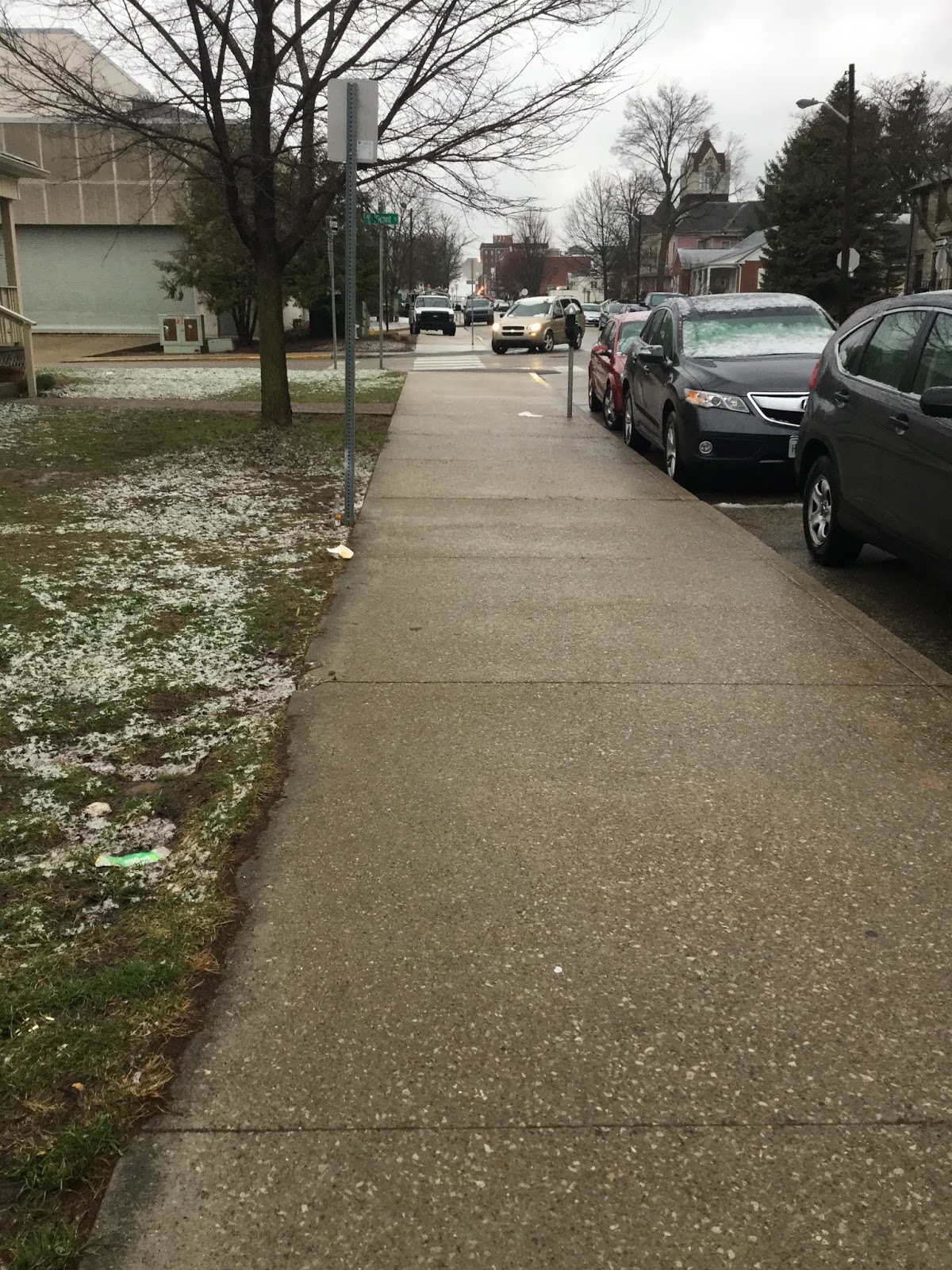
The first two weeks of April look to be cooler than normal /average.The National Weather Service gives us a 70% chance of rain and snow on Saturday night into Sunday April 1st. April 2nd to April 5th should interesting as well.
https://forecast.weather.gov/MapClick.php?x=160&y=187&site=ind&zmx=&zmy=&map_x=160&map_y=187#.Wru1e4jwaUk
Winter does not want to leave.
This year's winter season is stubborn. On the other hand, the good news is that when the cold weather persists it cuts back on the amount of severe weather and tornadoes we have in the spring. There's even a chance we could still see some more snow! No kidding. Look at details below along with the NWS discussion.


.LONG TERM /Thursday Through Sunday/...
Issued at 312 AM EDT Mon Mar 26 2018

Main focus for the short will be on timing of additional showery
activity.

Models were having timing differences with an upper trough that will
impact the weather over central Indiana late this week and early
weekend. The 00Z GFS is much quicker than the 00z ECMWF. Thus, the
GFS moves out the rain Friday afternoon, while the Euro does not
move it out until overnight Friday night. Prefer the Euro that most
closely resembles the blend PoPs. Confidence in timing is not high,
but at least it is consistent with the previous run. With that,
said, will not make any changes to the blend which has high Pops
Thursday afternoon through Friday.

After a brief dry period, a weaker wave will bring more shower
chances to the area for the late weekend. Confidence in exact timing
is low as the wave is not very distinct. Confidence is not enough to
make any changes to the blend, which brings small PoPs to all or
parts of central Indiana Saturday afternoon and on.

Models suggest snow could briefly mix in with the rain across the
north Thursday night into Friday morning and again Saturday night
into Sunday morning. That said, do not expect any accumulation.

Blend above normal highs of 55-60 degrees looks good for Thursday.
Then, temperatures should fall back to below normal in the wake of a
frontal boundary by Friday. Confidence in blend trends is good if
not precise temperatures.
Oh, oh oh, you mystify me...
That's from one of the lyrics from the Cranberries song called "Sunday". That is about the only way to describe what happened today. In Bloomington Indiana we saw a mixture of everything. We saw wind, rain, freezing rain, sleet, ice pellets and a combination of all this at times. There were times when it was dry and nothing happened but it definitely was a mixture of everything.
A lot of the models and forecasters gave Bloomington a chance of seeing 2-4 inches of snow. I also expected to see this early in the morning but it didn't pan out. I think Bloomington was right on the line of 33 degrees nearly all morning and afternoon. It wasn't until about 5:30pm in the evening that everything changed over to all snow and it snowed heavily for about three hours and quit. Although the Winter Weather Advisory lasts until 11:00pm, the radar is mostly all clear and I think this storm is over with and likely to be the last winter storm we will see in Bloomington until November 2018.
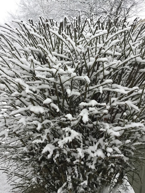
Currently it's 9:15pm with light drizzle and a temperature of 33 degrees here in Bloomington, Indiana. Here's what the snow looked like after 5:30pm today.


A lot of the models and forecasters gave Bloomington a chance of seeing 2-4 inches of snow. I also expected to see this early in the morning but it didn't pan out. I think Bloomington was right on the line of 33 degrees nearly all morning and afternoon. It wasn't until about 5:30pm in the evening that everything changed over to all snow and it snowed heavily for about three hours and quit. Although the Winter Weather Advisory lasts until 11:00pm, the radar is mostly all clear and I think this storm is over with and likely to be the last winter storm we will see in Bloomington until November 2018.
Currently it's 9:15pm with light drizzle and a temperature of 33 degrees here in Bloomington, Indiana. Here's what the snow looked like after 5:30pm today.


The warm air won!
Wow! We got lucky. The warm air intrusion from yesterday maintained its strength. It's 34 degrees in Bloomington and we are in the warm sector of the storm.

Some very light snow from early this morning; otherwise mostly light rain.


Some very light snow from early this morning; otherwise mostly light rain.
Central Indiana snowstorm for Saturday
I will be honest and say that I have no idea how this will turn out. The modeling and the track of the storm has shifted so many times that it's hard to say what will happen. Yesterday the storm was projected to be well to the north of Monroe County and barely included Morgan County. That has now shifted southwest with this morning's computer run. Some weather websites give Bloomington snow, others give rain (warm air-cold air battle) and the National Weather Service says ice. The good news is that once we make it to Monday, temperatures will warm up for next week. We'll see temperatures in the mid 50's for next week.
Here is the NWS's very long discussion of exactly how complicated this storm system is:
Here is the NWS's very long discussion of exactly how complicated this storm system is:
.SHORT TERM /Tonight through Saturday Night/...
Issued at 408 AM EDT Fri Mar 23 2018

The primary focus will be the potentially significant late season
winter storm poised to impact central Indiana beginning late tonight
and continuing into Saturday evening. There are still details to be
ironed out as we move into the 24 to 36 hour timeframe and multiple
items to consider that could drastically change precip type and
amounts in any one location. Lot to look at and consider.

The first order of business to address is the headline situation.
After discussion with neighbors and with confidence levels not yet
quite where would like to see them...have chosen to continue with
the Winter Storm Watch in its present state with an addition of
counties to the southwest based on a southward shift to the
potential for heavier snowfall off the 00Z model suite. With impacts
in the late second period and...more likely in the third period...
think there is still time to fine tune details and determine where
headline adjustments to warning and/or advisory would best fit. In
addition...the 12Z model suite should be able to capture the system
with the full RAOB network as it has comes ashore on the west coast
over the last several hours. That should hopefully iron out some of
the differences that still exist between various model solutions
which we will discuss below.

The upper wave will lift up and over the ridge centered over the
southern Plains later today and tonight before winging into the
region Saturday and gradually becoming absorbed by the deep upper
trough centered over the Canadian Maritimes and New England states
by late weekend. A surface low will accompany the upper
wave...ejecting out of the Rockies this evening then moving E/Se
into the lower Ohio Valley by late day Saturday. Overall model
agreement is decent regarding the main features with the exception
of the NAM which is a noticeable outlier to the north. Overall
ensemble guidance is tightly clustered and aligned with the op GFS
and ECMWF with the GGEM tracking slightly further south.

Rain will be overspreading the lower Wabash Valley during the
evening...with precipitation slowly expanding east across central
Indiana into the overnight as the initial surge of moisture and lift
contends with a notable layer of dry air through the lowest 10kft
courtesy of increasing easterly flow. As surface temps fall and
evaporative cooling commences in response to the saturation of the
boundary layer...will see precipitation transition to sleet and more
likely snow along the northern flank of the precip shield after
06Z...with the transition zone aligning somewhere near or just north
of a Terre Haute-Bloomington-Seymour line. Northeast of this
line...snow should become the predominant precip type through
daybreak with the potential for a light accumulation. This
transition line is likely to shift northeast slightly during the day
Saturday. Within the mix area...freezing rain is certainly a
possibility...but expect sleet will be the more prevalent precip
type outside of snow or rain based on model soundings.

The primary show however really looks to focus during the day
Saturday as the upper wave approaches with more substantial
deformation and frontogenesis develops and moves across the region.
The potential for a period of or bursts of heavy snow will come
during the day Saturday and should align in a NW to SE axis along
where the most intense deformation occurs just to the left of the
700mb low track.  Potential is there for a burst of more widespread
snowfall during the morning then after a brief break...more locally
heavy snow during the afternoon with the possibility of a convective
component. Cross sections continue to show a few hours from late
morning into the afternoon where strong vertical velocities and
moisture interact with the dendritic growth zone in the presence of
conditional instability. With the deformation axis likely to be
nearby at the same time...this is the time period where the heaviest
snow rates are likely to occur and a potential for a few rumbles of
thunder within the heaviest snow bands will exist. Further to the
southwest where rain remains the primary precip type...an isolated
thunder mention is warranted. Also...an impressive wind field
present through the boundary layer wrapping around the system will
lead to higher wind gusts Saturday that may peak at 30-40mph. This
will make the day even more miserable and in areas where a snow or
mix is ongoing...create greater impacts.

While all of the above presents a growing confidence in a
heavy...wet and impactful snow...low level thermals will offer a
challenge as they often do with late season winter storms. Surface
temps are likely to rise into the mid 30s over the northeast half of
the area with a warmer layer aloft that should warm advection be
slightly stronger than currently progged...could cause precip type
changes and/or limit heavier snowfall rates. The heaviest snow
falling during daylight hours highlights the complexity of the low
level thermal profiles even further. That being said based on the
forcing aloft and factors mentioned above...feel that rates within
the heavier bands will overcome marginal low level thermals and
cause problems at times. Precip will diminish as the system moves
away Saturday evening with skies clearing overnight.

So to summarize...the potential for significant winter weather
primarily in the form of snow remains high but some details still
need to be worked out. Would like to see an overall better model
consensus on the axis of heaviest snowfall...as the NAM remains
north and the ECMWF and GGEM have shifted much further southwest on
00Z runs. The overall consensus without the NAM does support a
slight shift to the southwest and have followed suit. As it stands
at this point...think the axis of heaviest snowfall is likely to set
up either side of I-74 by 20 miles or so. The axis will in reality
probably end up being tighter but would like to see better
consistency before committing to a narrower axis. Will continue with
snowfall amounts of 3-7 inches within the heaviest bands with a
potnetial for localized higher amounts which are common in banded
snow scenarios.

One thing to mention...warmer ground temps will likely lead to
compaction of snowfall relatively fast...especially once rates
diminish. Actual snow depths will likely be lower than snowfall
amounts for this reason. This will be cement block snowfall folks.

Temps...largely prefer the cooler end of guidance through the
period...especially on Saturday as temperatures are likely to be
kept down by precipitation and especially in areas where snow or
some form of wintry mix is prevalent.

&&

.LONG TERM /Sunday through Thursday Night/...
Issued at 353 AM EDT Fri Mar 23 2018

Ridging over the Great Lakes Region will result in dry conditions
early in the extended period. However, rain showers will slowly
start entering the southern portions of central Indiana early
Monday morning ahead of the next low pressure system over the
Central Plains. Significant Gulf moisture will be pulled into
central Indiana ahead of this system, resulting in heavy rainfall
at times on Monday and Tuesday along with embedded thunderstorms
in the warm sector. Latest blended initialization highlights
these periods well, so no adjustments were needed. The forecast
will remain active through the end of the extended period as a
trailing cold front moves through on Tuesday night followed by an
upper low late in the period. Meanwhile, temperatures will
initially start out below normal, but they will quickly climb
above normal due to strong warm advection with aforementioned
system.
Another snow storm this week?
It looks like central Indiana will be getting more snow this weekend but the track of the storm is not clear at this time. It looks like it will be north of Bloomington and Monroe County. Here's the latest thoughts from the NWS: (they added a sense of humor to the discussion!)
.SHORT TERM /Tonight through Saturday Night/...

Issued at 400 AM EDT Thu Mar 22 2018

Spring has sprung...or maybe not. Mother Nature continues to play
her cruel joke on central Indiana with another winter storm arriving
for the weekend. While tonight will be dry (only a slight chance for
any precip in the southwesternmost counties), lows will be in the
mid 20s to mid 30s. Friday will bring highs in the mid 40s to around
50 with chances for rain arriving in the southwest in the afternoon.
By Friday night, though, the rug is pulled out from us once again as
winter returns on a low pressure system moving out of the plains.

Strong frontogenesis along with upper forcing and some conditional
instability (showing up as negative EPV) are showing up in model
time heights in some spots at times from 6z through 18z Saturday.
This indicates the potential for some heavy snow. A low level jet
will be bring some moisture up into the area to continue to feed the
storm. There appears to be some potential in the forecast sounding
profiles for a zone of sleet/freezing rain somewhere in the area
dividing the rain area from the snow, and this will cut into total
amounts wherever it sets up. Doesn`t look like a lot in the way of
ice accumulation from this however, and right now looking at less
than a tenth of an inch in a narrow band. North of that band, with
the aforementioned strong forcing and some instability could see a
snow band with amounts approaching 6 to 8 inches. The cutoff between
snow and rain looks to be very sharp north to south with this
system, and could see counties with nothing on one end and several
inches on the other. With models coming into better agreement with
this system and the potential for heavy snow, have decided to issue
winter storm watch at this time for areas approximately along and
north of Interstate 74. Any change in the track of this potent
little system will change the location of heaviest amounts, and a
greater intrusion of warm air would cut total snowfall but possibly
bring more icing potential, so these will be things to watch in
upcoming forecasts.

Potential for snow and mixed precipitation will continue through the
day on Saturday and even into Saturday night. Think the worst should
be over by 0z Sunday if not before, so let the watch end then.
Across southwestern Indiana Saturday, enough instability is moving
in to add a slight chance for thunderstorms to the forecast to go
along with the rain there, and this is another indication of the
strength of this system.

The system should move out of the area late Saturday night and allow
dry conditions to return.


The first day of spring in Bloomington, Indiana.
Here's what the first day of spring is like in Bloomington Indiana today. Woo Hoo! #BOTS!


Winter is still hanging on all week long.
Here's NWS forecast discussion for today and rest of this week.
.SHORT TERM /Tonight through Thursday night/...

Issued at 411 AM EDT Tue Mar 20 2018

Main focus is on changeover to snow tonight and snowfall amounts.
Models in pretty good agreement and generally used a consensus.

Another upper low moves in tonight and keeps the surface low stalled
just southeast of the area. This could set up a strong deformation
zone over the eastern counties of the forecast area. Temperature
profiles indicate a changeover to snow from north to south from
around 8 pm to midnight. The best forcing will set up before
midnight but likely remain across the eastern counties through
much of the overnight. Given the cooler highs today and mostly
cloudy skies, road temperatures will start out cooler then last
night and cool to below freezing without much trouble. Snowfall
rates with the cooler but more saturated profiles and some
possible dendritic growth could approach an inch an hour at their
height, and thus think 4 inch amounts are possible across some of
the eastern counties. With the colder road temps and this bumping
up to the morning commute time, impacts and amounts necessitate a
winter weather advisory beginning at 8 pm and running through
midday Wednesday. Will likely be able to end the advisory a bit
earlier than that but including a buffer in case the system slows
even more as this has been a trend.

This system will finally kick out by Wednesday afternoon and dry
conditions will move in. Temperatures will rebound a bit Thursday
into the mid 40s to around 50, but more chances for precipitation
will arrive in the southwest counties Thursday night as a front
approaches. A wintry mix looks possible at onset.

&&

.LONG TERM (Friday through Monday)...
Issued at 311 AM EDT Tue Mar 20 2018

Mostly wet weather and below normal temperatures are expected this
weekend as Winter refuses to give up without a fight.

Models agree that the long term will start off with an upper low
over the northeastern states, a high amplitude ridge over the
central states and troughing over the west coast. Models also agree,
the central ridge will flatten as it moves overhead on Saturday.
Meanwhile, energy from the western trough and accompanying frontal
system will approach. Models have timing differences with these
features along with timing of QPF. So, confidence is not good on
timing and thus do not have enough to overturn the blend output
which has PoPs starting off Friday afternoon and maximizing Friday
overnight through Saturday evening. After that, upper waves in
southwest flow aloft could bring more showers to the area.

With below normal temperatures, nighttime and morning snow and or
wintry mix looks reasonable. Should see just rain during the
afternoon hours.

Confidence is high on below normal temperatures to start off with.
Meanwhile, temperatures closer to normal look good by Monday.
However, with model differences, confidence is low.
There must have been a brief period of heavy ice last night.
A wintry mix was most likely the cause of this.


No ice for Monroe County
We will get lucky and just have a cold rain here in Bloomington tonight and tomorrow. The northern third of the state will see some ice tonight. Ice will likely be north and east of the red line.


Unbelievable (and yet believable at the same time)
There was a 10% chance of rain or snow forecasted for this evening and now there are blinding white-out conditions in Bloomington, Indiana. I'm sitting at the Starbucks on South Walnut and it's snowing hard; so fast that it is beginning to stick.


Time to retire the #BOTS hashtag for this winter season.
Oh what a sad day. Outside of next Tuesday, the temperatures are going to be too warm to support snow as we head into late March. I know the snow haters are happy though. Now is the time we transition from one #BOTS to another #BOTS; or "Bring On The Snow" to "Bring On The Summer". (or Spring if you prefer).
Spring kicks off next week.
The official start of Spring will be on next Tuesday, March 20, 2018 at 12:15 EST. I wouldn't be surprised if we had our last snow on the first day of Spring. (See image details below)


Tuesday is just beyond the seven day forecast so there is no degree of certainty that it will snow but it it is something to keep an eye on. There's also the possibility of ice Friday night into Saturday. Here's how the NWS describes it:
.LONG TERM /Friday through Monday Night/...

Issued at 342 AM EDT Tue Mar 13 2018

A frontal boundary over Tennessee will result in a wintry mix
across the far southern counties early in the extended period.
But, it won`t be until Friday night and Saturday when
precipitation chances increase with an upper low, once again
starting with a wintry mix on Saturday morning. There seems to be
a lot of variability in models though, so will not deviate from
latest blended initialization. Sunday, ridging will strengthen
over central Indiana, resulting in dry conditions. However, the
pattern will shift again by Monday as another system approaches
from the Missouri Valley. For now, will continue to leave out
mention of thunderstorms this late in the period, but this could
change if dynamics continue to improve. Temperatures will
originally start out below normal on Friday, then climb above
normal over the weekend.
He's back!
After a two and a half week hiatus, old man winter is back. The national weather service has snow in the forecast for next week; next Tuesday 3/6 and Wednesday 3/7 specifically.
Subscribe to:
Posts (Atom)