Long Term...(Friday night through Thursday)
Issued at 141 PM EDT Thu Aug 31 2023

Hot temperatures are the main focus in the long term portion of the
forecast. It still appears heat indices will stay below critical
levels, and likely below 100F, but there are some uncertainties. See
analysis below for details. A low probability of rain emerges by
around the middle of next week, but dry weather will prevail until
then.

Since the pattern is somewhat different with the upcoming period of
heat compared to the previous period of heat, there are model
performance considerations. Questions include: 1. magnitude of
moisture return and 2. model bias with regards to temperatures
(which was an issue for the last period of heat). The previous event
saw anomalous moisture which was deep enough not to mix out and this
impacted temperatures (cooler than modeled). It also contributed to
high heat indices and heat related impacts.

On the synoptic scale, forecast confidence is quite high with
anomalous 500-mb heights. Multi-model ensemble run-to-run
comparisons may show a slightly more amplified/anomalous ridge and
slightly further east position into early next week, but generally
negligible changes sensible weather. It is these minor details with
potential model biases and moisture magnitude to could result in
minor shifts in our forecast over the next few days. We do not see a
path where we would substantially exceed 100F for heat indices,
however, given the synoptic-scale stability in medium range
guidance. So, heat-related illness should be fairly minimal during
this upcoming anomalously warm period.

There is a low probability of some precipitation Tuesday night into
Wednesday. It does appear that on the periphery of eastern surface
high, at least modified moisture return will occur early-mid week.
There is an upper low with low latitude subtropical origins that
will eject northeastward ahead a shortwave trough and potentially
enhance mid-high level moisture. This, in addition to modified low-
level moisture, should push precipitable water values above
climatology. As the aforementioned shortwave trough`s associated
front moves through sometime between Tuesday night and Wednesday
night (there is spread in the medium-range models), interacting with
moisture, this should bring at least sparse coverage of convection
across Indiana.

Looking beyond the 7-day period, there is above confidence in
continued above normal temperatures given the signal in the medium-
range ensemble suite. This should be a mostly dry pattern as well.
The heat will return next week.
Enjoy Friday and Saturday. The heat returns on Sunday with a high of 90 degrees. The heat will hang on though much of next week. Here's what the NWS says:
Did anyone see that beautiful storm of Salem Indiana Friday evening? (updated!)
Just spectacular. The storm played music! I was on the south side of Bloomington looking southeastwards when filming this. Enjoy!
Enjoy the great weather this week!
This is going to be an absolutely beautiful week! I am so lucky to be on vacation. How about that low temperature of 53 degrees Wednesday night? It will remind you that Fall is right around the corner. Fall starts in 25 days. It won't be long before we are talking about our first frost.


But, on the other hand, the heat will make a comeback on Labor Day so be prepared. In addition to that, the tropics are active right now. A hurricane is approaching Florida today. These tropical systems can inject humidity in our area so hopefully we won't see 90 degree heat plus 90% humidity. That's oppressive! Here is what the GFS model is saying for Labour Day, September 4, 2023.
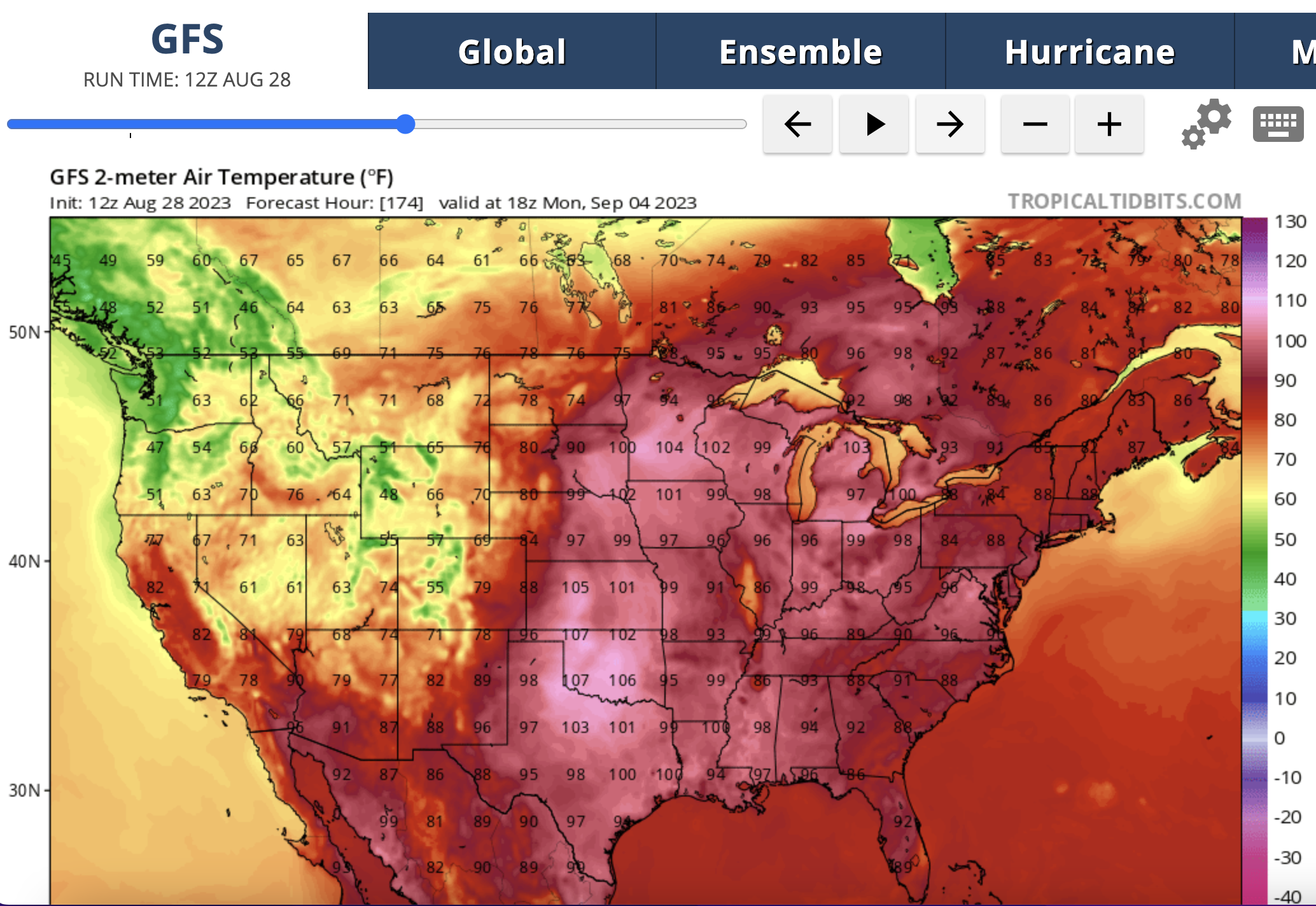
Here's what the EURO model says for that same day:

Bad news, then good news and then bad news again.
Bad News #1: The next two days are going to be extremely hot. I think we will see 100 degrees on Thursday.
Good News #1: Temperatures cool off to a high of 80 degrees by Sunday. Sunday through Wednesday will be nice.
Bad News #2: The extreme heat will return again next Thursday.
Good News #2: Fall starts in 1.11 months, 4.43 weeks, 31 days and in 744.0 hours.
Watch heat hand the cool air battle it out below:

I see signs of fall, do you see them?
For the past seven years I've noticed that the trees seem to change their colors in late August rather than in late September. Can you see the color changes here?


Update for next week: HOT!
Yes, I see the irony! My last post was back on July 25th and I said a heat wave was coming and it didn't really materialize but this next one is real because all the computer models are in agreement. They do differ slightly on the intensity of the heat (see below) but 90 or 90+ degree days are guaranteed next week. As Granny used to say, "You-kin tek dat to da bank!" So let's get started.


The National Weather Service has already issued Excessive Heat Warnings in Missouri. There's an Excessive Heat Watch in place for most of Illinois. I think something will be posted for Indiana by Sunday morning or evening. The National Weather Service office in Indianapolis is saying this:
.Long Term...(Saturday night through Friday)
Issued at 306 PM EDT Fri Aug 18 2023

Enjoy today`s cooler temperatures as the long term will jump back to
hot and humid conditions for the entirety of the period. Widespread
highs in the 90s will be likely and could prompt future headlines
for the heat.

An upper ridge moving in that looks to meander through the central
plains and Mississippi Valley for all of next week. This not only
helps to suppress much of the potential for convection but will also
allow the hot conditions. With that said, can`t completely rule out
the chance of afternoon pop up storms given the heat and moisture as
well as models showing us under the periphery of the ridge most of
the time. Confidence is low for now in regards to PoPs as these
would be more mesoscale features that the long term typically
doesn`t handle well.

Still thinking that models are really over doing the highs as they
are unrealistic for several reasons. NBM is doing better but still
likely a little high as it has overestimated a few times over this
summer already trying to forecast highs in the upper 90s. Thus, have
adjusted highs down ever so slightly for Tuesday through Thursday,
which will likely be the hottest days. Confidence is high that it
will be hot but exact high temperatures could still change some over
the coming days. Lows are expected to be near 70 so not much relief
overnight.
The National Weather Service office in Paducah, Kentucky has issued this for Evansville, Indiana:
Special Weather Statement
National Weather Service PADUCAH KY
205 PM CDT Fri Aug 18 2023

ILZ076>078-082-083-086-087-090-091-094-INZ081-082-085>088-
KYZ001>022-190815-
Wayne IL-Edwards-Wabash-Hamilton-White-Saline-Gallatin-Pope-
Hardin-Massac-Gibson-Pike-Posey-Vanderburgh-Warrick-Spencer-
Fulton-Hickman-Carlisle-Ballard-McCracken-Graves-Livingston-
Marshall-Calloway-Crittenden-Lyon-Trigg-Caldwell-Union KY-Webster-
Hopkins-Christian-Henderson-Daviess-McLean-Muhlenberg-Todd-
Including the cities of Fairfield, Albion, Mount Carmel,
McLeansboro, Carmi, Harrisburg, Shawneetown, Golconda,
Elizabethtown, Metropolis, Fort Branch, Petersburg, Poseyville,
Evansville, Boonville, Rockport, Hickman, Clinton, Bardwell,
Wickliffe, Paducah, Mayfield, Smithland, Benton, Murray, Marion,
Eddyville, Cadiz, Princeton, Morganfield, Dixon, Madisonville,
Hopkinsville, Henderson, Owensboro, Calhoun, Greenville,
and Elkton
205 PM CDT Fri Aug 18 2023 /305 PM EDT Fri Aug 18 2023/

...Extended period of dangerous heat forecast...

After a period of more comfortable conditions temperatures and
humidity are expected to increase sharply on Sunday. Conditions
are then expected to remain stagnant for several days. Heat index
values of 105 or higher are possible every afternoon from Monday
through at least Thursday. Unlike previous heat waves this summer
the chance of showers or thunderstorms developing to break up the
heat appears very low.

Forecast updates and heat watches and warnings/advisories will be
issued as the event nears, but those with heat-related concerns
should begin planning for an extended period of dangerously hot
conditions.
And now let's look at the models. As we already know, the European model is considered the best and is more reliable than the American model. The European model is the ECMWF and the American model is called the GFS but let's start with the American model first:

It shows 103 degrees on August 23. Now let's look at the European model:

It shows 101 degrees on August 24. The only difference is two degrees in 24 hours. This is very intersting to me because all summer these models have been disagreeing with each other by and especially beyond a 24 hour period.
So, all of this to say...it will be hot next week. Stay hydrated and remember your pets and check on your loves ones. Also, here's a bit of good news: Fall starts in 35 days. #BOTS!
Clarification: Someone asked me a great question so I wanted to clarify something. The temperatures in the models above are forecasts for actual air temperatures. They are not heat indices. Those (heat indices) will likely be even higher!
Subscribe to:
Posts (Atom)