Ouch! That is cold!

The CFS computer model is not well respected or trusted but it does a farily good job of picking up on warming or cooling trends in the long range. Check this out. The freezing line is down in Florida. That's doesn't mean it will be that cold on November 24th but it does *indicate* that a cold punch of air is likely during the second half of November.


37 degrees and patchy frost tonight.

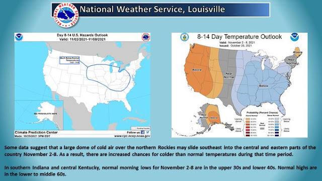
 Expect even colder temperatures for next week.


Short Term...(Today through Wednesday)
Issued at 255 AM EDT Tue Oct 26 2021

...Patchy Frost Tonight and Possible Fog Through daybreak Wed...

Early This morning:
Satellite imagery showing the trapped stratus layer over the Ohio
valley, with cold-dry air still advecting in from the northwest.
Lake effect clouds are apparent off of Lake Michigan as well with a
strong thermal differential and shallow moisture availability, which
could see as winds turn slightly northerly bending a few lake clouds
south into the northern forecast area prior to daybreak. Otherwise
the pre-dawn hours will be welcomed with some decreasing clouds as
the deeper moisture peels off to the east. Temps prior to daybreak
may dip a few more degrees, but will hinge on clearing and
decoupling the mixed layer to relax the winds. This would then allow
some additional release of heat from the surface and drop temps into
the lower 40s where dewpoints are presently.

Today-Tonight: Mid-lvl heights begin to rise quickly today as an
amplifying ridge quickly pushes east ahead of the next system. This
ridging will continue to scour the moisture in the atmosphere, but
also produce a mostly sunny day. Temps may be slightly sluggish to
warm given the saturated soil conditions across the region,
absorbing much of the radiation from the sun, but still expect temps
to push into the mid to upr 50s. The peak of the ridge slides
overhead later this evening, setting the stage for a quick drop in
temps post-sunset. Expecting considerable radiational cooling to
take place evening/overnight, with minimal wind being mixed down and
a dry profile. This should see a release of heat into the mid/upr
30s across the forecast area by early Wed morning, but could also
see some radiational fog develop. It is conceivable that a few
locations in the far north/northeast or along and east of a
Lafayette to Muncie line falling to around 33-35 degrees or flirting
with freezing conditions. Confidence is low that we will need any
growing season headline; however, some patchy frost is favorable.
The fog may not be as potent as once thought, given there may still
be some wind albeit less than 5 mph, but in the valley and low-lying
areas fog will likely develop in the canopies.

Wednesday: 500mb heights will remain elevated through daybreak Wed,
as the approaching Pacific system has a slightly negative tilt. This
suggests the energy in the lower levels will have pushed east of the
upper level support, which guidance indicates the surface low will
be lifting northerly from the Arklatex region midday wed. Gulf
moisture continues to be primed for being ingested into this system
in the lower levels, which will only further expand the precip
shield later Wed. Still confidence the heights aloft of Central
Indiana will hold, helping to prolong the diffluent flow and delay
precip arrival until later Wed.

With continued minimal cloud cover Wed, expect a large diurnal swing
in temps for much of the area as the surface can realize and absorb
the sunlight and push temps to around 60 by midday. Then flow will
begin to turn southerly with cirrus shield steadily increasing from
south/southwest to north in the afternoon.

&&

.Long Term...(Wednesday night through Monday)
Issued at 255 AM EDT Tue Oct 26 2021

...Wednesday Night into Saturday...

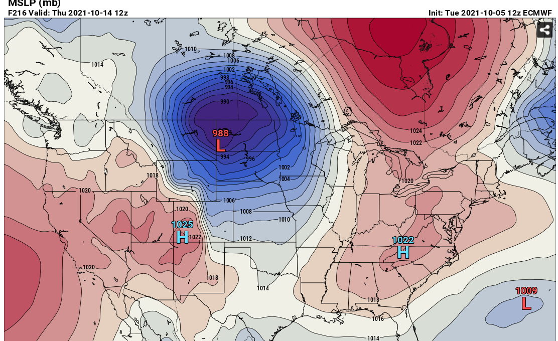
Another good dose of rainfall is expected late in the week as the
powerful Pacific system moves eastward across the country and closes
off by Wednesday morning over the Plains.

The large upper low will slowly push eastward across the Ohio and
Tennessee Valleys Wednesday night into the early portion of the
weekend, with showers possible throughout that time frame, but
particularly Thursday into Friday as forcing and precipitable water
values are maximized. Models are generally in good agreement that
precipitable water values will be high but not massively so,
generally a bit above the climatological 75th percentile or a bit
below 2 standard deviations for the time of year...or as high as
about 1.1 to 1.3 inches.

Total precipitation during the latter half of the week looks to be
about 0.75 inch to 1.5 inches, which should not significantly worsen
the current hydrologic situation, in part thanks to the prolonged
time frame of the rainfall. This will, however, prolong the elevated
streamflows and any return to baseline hydrologic conditions.

...Saturday Night into Monday...

The latter half of the weekend should be dry as a narrow axis of
upper level ridging and surface high pressure move into the area.

...Monday Night into Tuesday...

A solid cold front looks to move through the region early next week,
which may produce some additional showers as cyclonic upper level
flow drops into the Midwest. A good cooldown should accompany this
front with overnight lows by the end of the forecast period dropping
well into the 30s. Model handling of this front and the potential
for surface low development along it differ far more substantially
than with the earlier system and result in fairly low pops for now.

ICYMI, there was an earthquake drill this morning.

"The Great American Shakeout is a FEMA-directed MIdwest earthquake simulation that is scheduled for October 21 at 10:21 am. Over 1.6 million people in the Midwest have registered to take part in this drill including schools, businesses, and individuals."

https://www.shakeout.org/centralus/participants.php?start=Indiana


NOAA realeased its official 2021-22 winter outlook today.

 It's bad news for #BOTS fans. It looks like this winter season will be warmer than average.


Click on the link below to read the full report.

Click to see the youtube video below.


Storms are possible Thursday night into Friday night.


 Here are the complete details from the National Weather Service:

Short Term...(Today through Friday)
Issued at 307 AM EDT Thu Oct 14 2021

Broad warm advection regime ongoing this morning across the Ohio
Valley and advecting deep moisture into the region. This has brought
plenty of cloud cover and in some spots lower stratus. A few showers
were across the Wabash Valley and continued to weaken as they moved
away from the primary areas of lift closer to the cold front back
across western Illinois. Humid conditions currently by October
standards as 0630Z temperatures were in the upper 60s and lower 70s
with dewpoints in the upper 60s as well.

Active and unsettled weather will dominate the short term with
increasing threats for heavier rainfall and embedded convection by
late today throughout the day Friday. Aforementioned cold front
extending from an occluding low pressure over the northern Plains...
then looping through the western Great Lakes back into the mid
Mississippi Valley and southern Plains. The boundary is in a quasi-
stationary state this morning due to a couple factors: 1) the front
has become nearly parallel with broad southwest flow aloft...2) the
front is being left behind by a deep upper low and the northern
Plains surface low which will track north into Manitoba through the
day...and 3) its forward progress is effectively blocked by a large
surface ridge extending from eastern Canada into the southeast
States.

The boundary will drift east slowly today and eventually settle into
the region tonight and Friday which will put central Indiana in the
bullseye for rounds of convection and locally heavy rainfall
beginning late today and persisting through Friday night. The
development of a secondary surface wave on the boundary over the
southern Plains late today will ultimately be partly responsible for
kicking the front east of the region by the beginning of the
weekend. This wave will lift north into the Ohio Valley on Friday
and strengthen as a upper level trough approaching from the west
amplifies late Friday.

Convection is firing along the boundary early this morning in
western Illinois aided by stronger 850mb flow. While some of this
activity may sneak into the northern Wabash Valley later this
morning...expect the bulk of this convection to track N/NE and
remain to the northwest of central Indiana. Additionally...a few
showers and perhaps a rumble or two of thunder will be possible
through early to mid afternoon across the northwest half of the
forecast area...but expect the bulk of the rain will remain in
proximity to the boundary to the west.

The impacts from this multifaceted storm system will come in two
parts with the first one set to commence by late day as the front
approaches our northwest counties and continue tonight and through
Friday morning with the boundary likely to be bisecting the forecast
area from southwest to northeast by predawn Friday. Tropical
moisture from the remnants of Pamela currently over northern Mexico
will continue to advect northeast along the boundary and into the
region over the next 36-48 hours. This will bring unseasonably high
PWATs into the Ohio Valley peaking near the climatological max and
at roughly 250% of normal for mid October. The deep moisture plume
will interact with increasing isentropic lift and a developing
nocturnal low level jet to bring increasing convective coverage in
the zone along and immediately ahead of the cold front tonight
across the northwest half of the forecast area...with some training
of cells as well focused along an axis near or perhaps just north of
a Terre Haute-Indy-Muncie line. Will focus highest pops in this area
overnight with activity likely to be more scattered across southeast
counties. Weak instability aloft will be sufficient for scattered
thunderstorms as well and certainly appears some locations may see
upwards of an inch through Friday morning.

Enhanced low level flow from the southwest will maintain numerous
showers and storms into early Friday afternoon...but the increasing
influence from the approaching upper trough will change the game a
bit for Friday afternoon into Friday evening...as additional
parameters come into play to maintain precip coverage and likely
present an uptick in convective intensity as well. The secondary
surface wave will be in the process of intensifying as it tracks
across the region Friday afternoon...and model soundings/RH progs
both hint at a narrow window for scattering of cloud coverage which
would increase heating and consequently instability. The confidence
level is higher in this occurring south of the region across the
lower Ohio Valley into Tennessee...but increasing BL shear and low
level SRH ahead of the front even up into central Indiana at least
raises the potential for a short 1-3 hour period for severe storms
during the late afternoon and early evening focused mainly across
the southeast half of the forecast area. Damaging winds would be the
main concern but the higher SRH values and presence of directional
shear in the near surface layer at least offers the possibility for
a few rotating cells as well. Lot of moving parts here and would
like to see all of the parameters better phased...but this will be
something to monitor.

To sum it all up...primary concerns remain focused on heavy rain and
the potential for localized flooding with growing confidence at 1-3
inches of rain across much of the forecast area by Saturday morning.
The thermodynamic setup is supportive for embedded thunderstorms
throughout the next 2 days with a slightly higher ceiling for a
short period late Friday afternoon and evening for severe storms.
Rain will continue into Friday night before tapering off early
Saturday as the system moves east. More on the tail end of the storm
system and its impacts in the long term section below.

Temps...Even with a fair amount of cloud cover and limited sunshine
today...should not have much trouble warming into the upper 70s and
lower 80s across much of the forecast area considering our very warm
start this morning. Temperatures on Friday are more challenging with
the boundary draped across the forecast area. Low level thermals
largely support a range from the lower 70s over the northern Wabash
Valley to the upper 70s in the southeast counties. Lows tonight will
range from the upper 50s north to the mid 60s south of Interstate
70.

&&

.Long Term...(Friday Night through Wednesday)
Issued at 307 AM EDT Thu Oct 14 2021

The period will begin as central Indiana is transitioning regimes
from warm/rather humid to cool/quite dry...amid soaking rains and
thunderstorms as a strong cold front crosses the CWA. By Friday
evening, the day`s moderate to locally heavy rainfall will be
tapering off from west to east. Strong, to perhaps briefly severe,
thunderstorms will be possible east of the I-69 corridor as 150-250
m2/s2 of 0-3 km storm relative helicity, and up to 70 kts of 0-6 km
bulk shear attempt to catch what very limited instability may linger
ahead of the front after 00z. Appears the ample dynamics may just
miss this opportunity, although any small variations in the quick
frontal passage`s timing would certainly change the scenario.
Nevertheless after 00z high confidence in rain ending west to east,
moderate confidence in a few lingering heavy downpours east of Indy,
and low confidence in any severe storms.

Saturday will, despite ample sunshine, feature the coolest afternoon
highs since the second week of May...as the region dries out
courtesy of west-northwesterly surface wind gusts as high as 20-25
mph as the exiting system`s upper level trough axis crosses Indiana.
Several dry days of seasonably chilly mornings and pleasant autumnal
afternoons weather will follow, with Gulf moisture cut-off from the
Mid-West by high pressure prevailing over the eastern US. Conditions
will slowly moderate amid modest southwesterly winds out of the
surface ridge axis to our south, and mid level heights slowly rising
as a ridge approaches from the Plains while flattening.  Mostly
clear skies under H850 temps trending from about 5C on Sunday to
near 12C by Wednesday...support slightly below to slightly above
normal temperatures.  The normal max/min for the long term period is
65/45.

Lower confidence surrounds the end of the long range, on where any
wave would develop over the central US as Canadian air descends into
the US, however decent certainty that any slight chance POPs would
hold off until at least after Wednesday.

Whoa! 81 degrees for the high tomorrow.

Strong storms are possible Friday. Winds gusts could get up to 22MPH. I recommend bringing in your Halloween decorations for Friday. They could get blown away.


10/7/21 Update

Not much has changed except temperatures could climb into the mid 80's this weekend and that could last until next Tuesday. Storng storms are likely somewhere in the middle of the country next week. And the last week of October continues to look very itneresting. This morning's run of the GFS computer model spit this out:


Spring (Part 2) is coming up!

Rain showers are likely today through Thursday night. After that, high tempratures will go into the low 80's for the weekend. Spring returns next week. If you didn't know this, we have two severe weather seasons here in central Indiana. They are in the Spring and in the Fall as both cold air and warm air fight it out, and that is exactly what is going to happen next week and the week after that. Finally, the fun and games begin on the last week of October. #BOTS!

Here's an example of a cold front moving through late next week. The GFS puts this near October 16.


Although the hazzard type says "NONE" in the sounding, the box to the left says "CLASSIC SUPERCELL".


The European computer model does a great job of showing the contours and clashes of the competing air masses. Can you spot the battle zone?


The National Weather Service is saying this about the long term forecast:

.Long Term...(Thursday night through Tuesday)
Issued at 246 AM EDT Wed Oct 6 2021

Thursday night through Sunday.

By Thursday night, the aforementioned low pressure system will be
centered over Illinois with continued strong southerly surface flow
bringing in waves of moisture which is expected to interact with
plenty of forcing aloft to create scattered to widespread showers
through the night. The heaviest rain looks to fall earlier in the
day when the LLJ is strongest, but rain should continue through the
night. During the day Friday, the low is expected to weaken and
broaden out as it continues to move to the north and connect with
the polar jet.  Surface flow will remain southerly but at the 800 to
500mb layer, the moisture advection really begins to cut off which
looks to limit the intensity and coverage of precipitation. By
Saturday, the low will be fully integrated with the polar jet and
high pressure will begin to build across Indiana and the Ohio
Valley. Dry weather is then expected Saturday and Sunday.

Monday and Tuesday.

A more substantial fall system is expected Monday into Tuesday with
a strong upper level low deepening as it exits the lee of the
Rockies. Confidence in the system`s impacts for central Indiana
remains fairly low at this time with fairly significant model spread
on both the path and strength of the low as it moves across the
Central Plains.  The system has the potential to bring storms and
possibly severe weather as it moves into the Midwest and will have
to be monitored in the days to come.

Temperatures will gradually warm through the first part of the
period as the low exits and high pressure builds.  Early next week,
cooler temperatures are expected to return although still remaining
above normal.