Have a Happy All Hallows Eve

Rainy from now until Friday morning. We'll see a beautiful Saturday before rain returns for Sunday night. Things seem to change after November 8. The GFS is hinting at cold and snow.


Peak fall colors are happening now.

Get your best fall pictures today and tomorrow. Heavy rains come in for Wednesday and Thursday.

Analysis and thoughts.

Highs in the 50's and lows in the 40's the next three days. This pattern will stay for a while. Things look very interesting around November 3rd to November 6th. Will see what tomorrow's computer run says. Most people are saying that November will be warmer but I'm not quite sold on that idea yet.

Also, if you love taking pictures of fall colors then I would suggest taking your camera with you this weekend and all of next week. The leaves are quickly approaching their peak colors. I'll post more pictures when I have them.

Fall colors are nearing their peak

That wind storm over the weekend brought down a lot of leaves. I doubt we'll see the spectacular colors that we've seen in years past.


North eastern Indiana to get some lake effect snow this weekend.


When is peak fall foliage in Bloomington Indiana?

Technically the correct answer is October 29th but this has been a strange year. I've seen trees that are completely bare and trees that have some color and trees that are completely green. Given this, I'm going to say that next weekend will be the peak for fall colors. I'll say between the 25th and 30th. Don't expect it to be as spectacular as in past years.


Tornado Research bullet points from the NWS Louisville Office.

A study published recently in npj Climate and Atmospheric Science, by Vittorio A. Gensini of Northern Illinois University and Harold E. Brooks of the National Severe Storms Laboratory, looked into the possibility that tornado frequencies are changing across the United States. Their findings include a decrease in the traditional "Tornado Alley" of the Great Plains and an increase in the Southeast's "Dixie Alley". This study generated a fair amount of buzz, so we thought we'd briefly list out a few of the more important points mentioned in the study:
  • After removing non-meteorological factors, the annual frequency of U.S. tornadoes through the most reliable portions of the historical record has remained relatively constant.
  • Detecting spatial shifts in tornado frequency is challenging. Tornadoes are short-lived and affect very small geographical areas. Also, tornado reporting procedures have varied dramatically over the years and from one region to another.
  • The study used the Significant Tornado Parameter (STP) to account for tornado frequency.  STP is designed to highlight the existence of atmospheric ingredients favoring large storms capable of producing EF2-EF5 tornadoes, like what is typically seen in the Great Plains.
  • It should be noted that even if the atmosphere is supportive of tornadoes with the right winds, moisture, and instability, thunderstorms won't form without a strong enough trigger to spark them (like a cold front). The STP does not account for whether or not a trigger is present.
  • However, STP values correspond with tornado reports closely enough such that STP is a suitable index to use. STP is especially useful in January, February, March, May, and December.
  • The period analyzed in this study was from 1979 to 2017.
  • A significant upward trend in tornado frequency was found in portions of the Southeast, Midwest, and Northeast.
  • Both tornado reports and tornado environments indicate an increasing trend in portions of Mississippi, Alabama, Arkansas, Missouri, Illinois, Indiana, Tennessee, and Kentucky.
  • It should be kept in mind that STP is designed to evaluate environments favorable for large storms typical of the Great Plains, and not necessarily small spin-ups that we see in regions farther east.
  • Unfortunately, increases in tornado frequency in the American South juxtapose with a population that is especially vulnerable to tornadoes. The Southeast already represents a maximum in the occurrence of tornado casualties.
Keep in mind that this study was not associated with nor is it necessarily endorsed by NOAA or the National Weather Service. This information is presented here simply because of public interest.
It should be noted that this is just one study. Nevertheless, it is important for residents of the Ohio Valley and southeast United States to always be prepared for severe weather, including tornadoes. Right now, when the weather is quiet, is an excellent time to put together a tornado safety plan for your family. Have a survival kit and your plan in place well before severe weather strikes!

Tornado Research Paper in the NPJ

I thought Indiana was seeing fewer tornadoes but research shows otherwise.

Spatial trends in United States tornado frequency.


Low temperature drama for tonight.

Everything from 29 - 33.


The National Weather Service can't make up its mind.

Freeze or no freeze tonight? That is the question.


First freeze is tonight.

The National Weather Service office out of Indianapolis has not put Monroe County in the Freezing advisory list but it is clear that the temperature will be 31 degrees tonight.


First frost is tonight.

Bloomington will experience it's first frost of the fall season. What a difference a week can make. Last Monday we got to a high of 86 degrees. Tonight's low temperature will be 33, one measly degree above freezing. Don't forget to get your ice scrapers out.


The plot thickens.

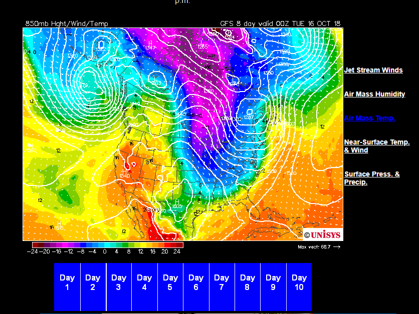
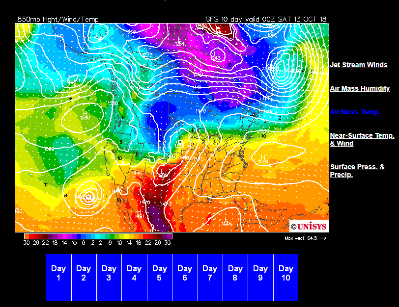
This is from the National Weather Service office out of Indianapolis.


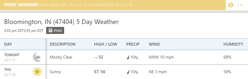
Also, patchy frost is a possibility tonight.

Special Weather Statement

Special Weather Statement
National Weather Service Indianapolis IN
340 PM EDT Fri Oct 12 2018

INZ021-028>031-035>049-051>057-060>065-067>072-130730-
Carroll-Warren-Tippecanoe-Clinton-Howard-Fountain-Montgomery-
Boone-Tipton-Hamilton-Madison-Delaware-Randolph-Vermillion-Parke-
Putnam-Hendricks-Marion-Hancock-Henry-Vigo-Clay-Owen-Morgan-
Johnson-Shelby-Rush-Sullivan-Greene-Monroe-Brown-Bartholomew-
Decatur-Knox-Daviess-Martin-Lawrence-Jackson-Jennings-
Including the cities of Lafayette, Frankfort, Kokomo,
Crawfordsville, Anderson, Muncie, Indianapolis, Terre Haute,
Shelbyville, Bloomington, Columbus, Vincennes, Bedford,
and Seymour
340 PM EDT Fri Oct 12 2018

...PATCHY FROST POSSIBLE OVERNIGHT...

Some decrease in clouds late tonight along with light winds will
allow temperatures to fall into the lower to middle 30s
overnight. This will allow patchy frost to form, especially in
sheltered areas.

Sensitive plants may be damaged if left unprotected.

Oh! What is that?

What's that blue stuff on the radar showing up just west of Lebanon Indiana?


Fall has arrived.

Frost Advisories are going up for northern Indiana. Bloomington probably wont get one until Monday night. Also, one of the models has some snow mixing in on Saturday.


@ 7:15pm

Front is a slow mover. Front arrives between now and 10pm.

@ 6:00pm in Bloomington Indiana

I know it looks so beautiful out there but please be aware that the main event has not happened yet. The cold front and storms associated with it are on the Illinois / Indiana border. Once this passes, then it will be all over. ETA is between 7:00pm and 7:30pm.


But yes, it does look beautiful outside. I caught a rainbow just after the rain stopped along 6th Street.


Will the south east ridge make a comeback?

AccuWeather's long range forecast shows above normal temperatures into January with our first snow being on January 6th.


A big change is on the way.


Fall arrives on Thursday!

Due to the tropical storm in the gulf and a strong cold front to our west, cooler weather will arrive Wednesday night into Thursday. We can expect high temperatures to be in the 80's until Wednesday and then it cools down significantly. Finally, the southeast ridge will break down.

Check this out. This is for a week from tomorrow or October 16th.


The first frost and /or freeze will be possible for a lot people in Indiana and maybe a few snow flurries for northern Indiana.


Two weather models are suggesting October 11th.

It looks like fall will try to make it's way to Indiana around October 11th. Until then, expect temperatures in the mid to upper 80's from now until next Wednesday.

Epic battle for mid October

Cold versus warm will battle it out around October 15th. Which one will win? Is it number 1 or number 2?


The warmth continues.

The southeast ridge refuses to move. New models are hinting at cold air coming in on October 16th and one even has snow but that's too far away to take seriously. Remember that the models were hinting at cold air for October 4th back in September and that turned out to be wrong. I guess this is what makes the weather so interesting to me. Weather and financial markets are yin and yang of order and chaos; the essence of life itself.

Here's the GFS model for October 13th.


Trailer: Storm of Suspicion

Where are the fall-like temperatures?

I don't see any signs of it until October 17th. It also depends on how long and how strong that southeast ridge will be.

Warm weather to continue.

The southeast ridge is refusing to move. The cold air is trying to come in but it is being blocked by the southeast ridge. This means that we will see slightly warmer than normal temperatures for October. The average high temperatures for October should be in the high 60's to low 70's. We will see temperatures in high 70's to low 80's.

.LONG TERM /Thursday through Monday/...
Issued at 316 AM EDT Mon Oct 1 2018

An active and warm long term period is expected as a frontal zone
with multiple disturbances impinge upon the area. Most every
period will feature thunderstorm chances somewhere across central
Indiana, although there will be dry stretches in there as well.

Temperatures will remain summerlike, with highs during the period
generally ranging from the upper 70s to mid 80s. Blended
initialization handled things well and few changes were required.