There are extreme weather graphics being posted to #INWX. Don't believe them!
https://twitter.com/hashtag/inwx?f=tweets&vertical=default&lang=en
A radar return from last night's storm system.
I've never seen this before. Storms were elongated from south to north when we were on the warm side of it. If you heard the wind last night, you could imagine how this could happen.


Dear #BOTS fans:
I am sorry to be the bearer of sad news, but our grandfather Old Man Winter passed away last Saturday from complications of a negative PNA pattern and a positive NAO pattern. He had been experiencing these symptoms for several weeks. The the polar vortex was intended to alleviate the problem but failed.
Following his wishes, we held a graveside service with at the Winter family plot in the Springfield City Cemetery. Old Man Winter was a modest, private man and wanted it that way. He is survived by his two melting children; Snow-man and Snow-woman.
______
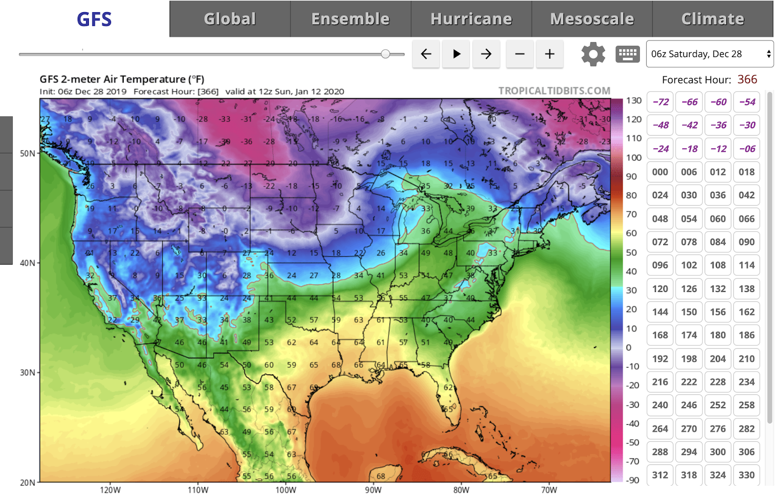
Check out the above average temperatures for the next two weeks.


Following his wishes, we held a graveside service with at the Winter family plot in the Springfield City Cemetery. Old Man Winter was a modest, private man and wanted it that way. He is survived by his two melting children; Snow-man and Snow-woman.
______
Check out the above average temperatures for the next two weeks.

From the NWS:
LONG TERM /Tuesday through Friday Night/...

Issued at 352 AM EST Sat Dec 28 2019

After a few lingering rain and snow showers (NE third of central
Indiana) early Tuesday, high pressure will strengthen over the
region, and dry conditions can be expected late Tuesday through
Wednesday. Meanwhile, a weak warming trend will commence through
the period. High temperatures will start out in the upper 30s/low
40s on Tuesday and increase to the upper 40s/low 50s by Friday.
Overnight lows will also climb from the 20s on Tuesday night to
mid 30s by Friday night. After the dry period, focus will then
turn to the next system approaching from the southwest late in the
period, which will bring a more active pattern through the end of
the forecast period with chances for mainly rain showers and some
snow showers from Wednesday night through Friday.
Cold Thursday morning and then a warming trend.
Expect above average temperatures for the second half of the month.


Good news and bad news for the long term.
The good is that temperatures will be above average from December 20th to the 31st. The NWS 6-10 day outlook looks like this:


The bad news is that #BOTS fans will not see a white Christmas.

And NWS 8-14 day outlook looks like this:

The bad news is that #BOTS fans will not see a white Christmas.
12/17 Tuesday morning commute will be icy.
Get up early and use caution when driving tomorrow morning. Drive slowly and leave 2-3 car-length spaces between you can the car in front of you. And please don't be lazy; clean the damn snow and ice off the top of your car. That can injure someone or damage another person's vehicle when it gets blown off onto the traffic behind you.
B.
B.


These guys again!

This is America. If you want to pay for a weather forecast, you can. That's your prerogative. I wouldn't do it because I trust the professionals at the National Weather Service and they provide weather predictions for free. And, there's a whole host of other free websites and apps for Android and Iphone that will do the same thing. All the data comes from the National Weather Service. Everything else is mere, conjecture, art and interpretation.
Now, that's not to say that these people are not professionals. They are. They hold professional degrees in meteorology. But, I would never pay for a weather forecast when you have the experts at the National Weather Service giving it to you for free. That's just MHO.


St. Louis NWS has the best take on winter forecasting.
The National Weather Service in St. Louis published this regarding next week's *possible* snowstorm:


A snowstorm next week?
Ahhh, maybe. It's way too early to tell. The models have been going back and forth. At this distance we have an equal chance of seeing a rainstorm.

From the NWS:

From the NWS:
.LONG TERM /Saturday through Tuesday/...
Issued at 240 AM EST Wed Dec 11 2019

A Pacific Northwest system and a combination of a southern inverted
surface trough and another upper Pacific system will bring chances
for rain and or snow showers to the area this weekend into early
next week. The best chances per the blend look to be Saturday with
the first system and next Monday and Monday night with the second
one. Confidence in exact timing and coverage is not great, so will
lean on the blend until the systems get closer and the picture looks
clearer.

Low level thermal progs and expected cloud cover support slightly
above normal temperatures on Saturday and below normal temperatures
thereafter. Blend highs in the 40s on Saturday and 30s the rest of
the long term look reasonable.
#BOTS Fans.
What do you think of no snow for Indiana? Doesn't this look cruel?

Luckily this is the CFS model which is notoriously unreliable so maybe the opposite will happen.

Luckily this is the CFS model which is notoriously unreliable so maybe the opposite will happen.
The pattern seems to be locked in.
Well folks, the pattern seems to be set. This will be a quiet week. I don't see anything happening until Sunday night when there's a 40% chance of rain.
The overall pattern appears to be locked in. It goes a little something like this: A warm front approaches and brings a high wind storm and rain ahead of a strong cold front. Then the arctic air attacks and changes the rain to snow. The arctic air hangs out for a while and then retreats. Then it warms up before the next wind storm and rain arrives. As they say, "Wash, rinse, repeat."
Here's an example of what I mean:

Here's the latest discussion from the National Weather Service:
LONG TERM /Saturday through Wednesday/...

Issued at 304 AM EST Wed Dec 4 2019

Dry weather is expected to start the period with chances for rain
beginning late this weekend into early next week. Surface high
pressure will be weakening during the day Saturday ahead of a
surface cold front that will be approaching the area. Chances for
rain begin Sunday afternoon in as southerly winds advect
seasonably warm and humid air into central Indiana. Chances for
rain increase into Monday as the gulf moisture interacts with the
aforementioned surface cold front.

Current thoughts are the best chances for rain will be late
Sunday into Monday when forcing out ahead of the front is expected
to be strongest with the heaviest axis of rain south of the
forecast area. Small chances for rain continue into Tuesday with a
possibility of a rain/snow mix during the day Tuesday which be
dependent on how quickly the cold front exits the area and
precipitation ends. Dry conditions are expected for Wednesday
with strong cold air advection bringing the coldest temperatures
of the period.

Temperatures are expected to be above average Saturday through
Monday with below average temperatures Tuesday and Wednesday.
Subscribe to:
Posts (Atom)