
Wild temperature swings coming up.
16 degrees and snow tonight and it will be in the mid 60's on Monday. This will feel great but remember that winter is not over. It looks like the cold is reloading and preparing for a comeback during the second half of February. Maybe a snowstorm between the 6th and 9th.


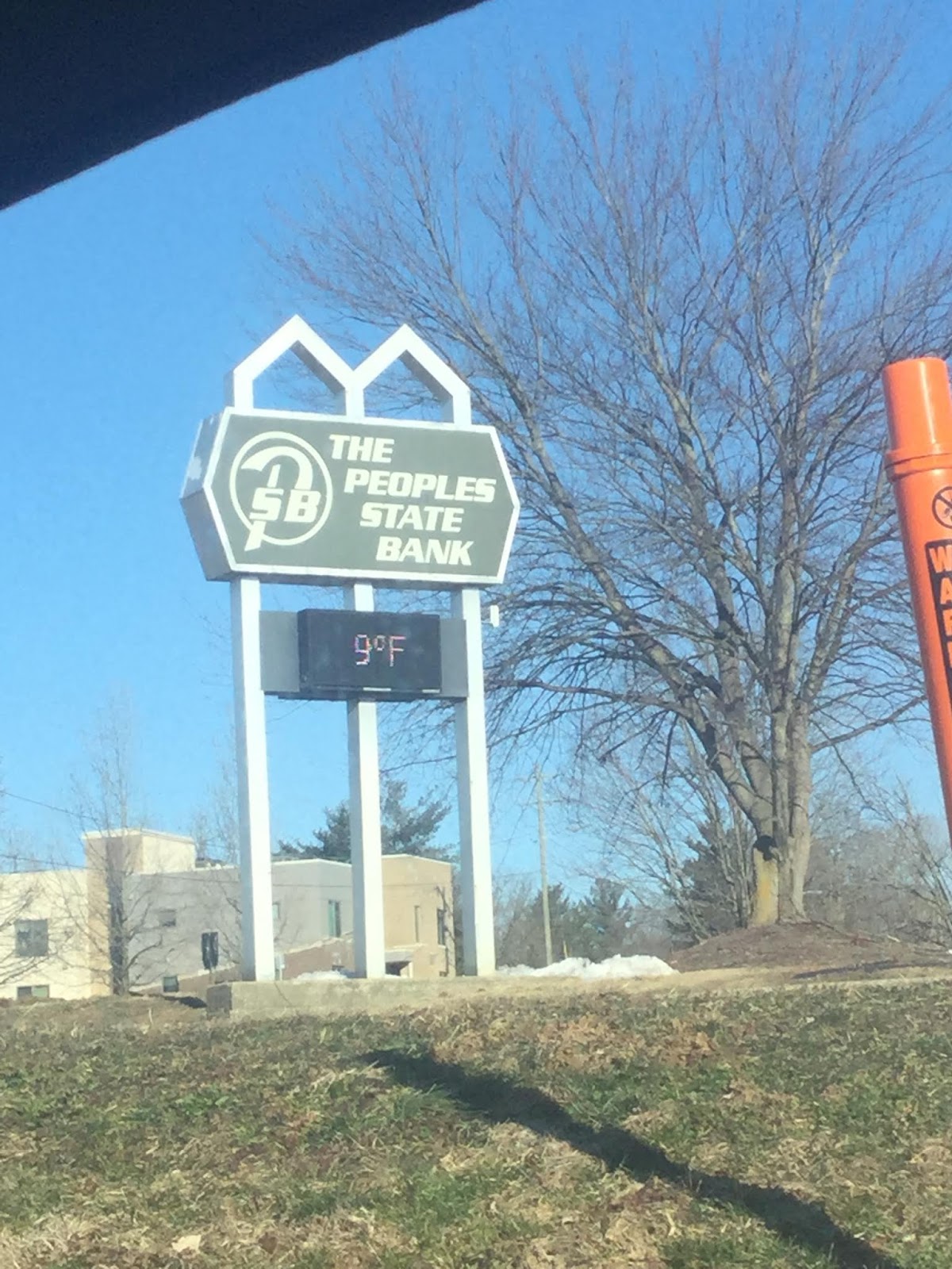
Tuesday night and Wednesday night will be the coldest we've seen in a long time.
If you have an old car like mine (like a 1990's era Honda Civic) and you do not have a garage, you might want to disconnect your car battery and take it inside. Sub-zero temperatures are battery killers.
You might also consider putting a piece of cardboard in front of your radiator.
You might also consider putting a piece of cardboard in front of your radiator.

Anniversaries.
1978 January 25-27th - The Great Blizzard of '78.
2009 January 26-28th - Ice and Snowtorm
https://en.wikipedia.org/wiki/January_2009_North_American_ice_storm
https://www.weather.gov/ind/jan282009snow?platform=hootsuite
https://www.weather.gov/media/pah/Top10Events/2009/Ice%20Storm%20Jan%2026-28%202009.pdf
https://en.wikipedia.org/wiki/Northeastern_United_States_blizzard_of_1978


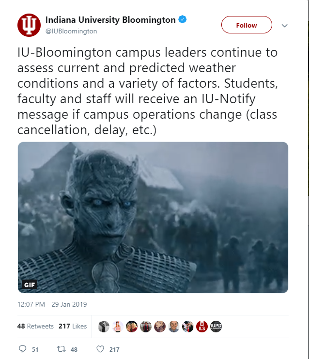
It's going to be COLD!
It will be dangerously cold next week. Do not leave home without a winter emergency kit in your car.

Car batteries will likely die next week because we are talking about the kind of sustained cold weather that normally happens in Minnesota or North Dakota where they have plug-in outlets for block heaters in their cars.
From the NWS: (emphasis is mine)

Car batteries will likely die next week because we are talking about the kind of sustained cold weather that normally happens in Minnesota or North Dakota where they have plug-in outlets for block heaters in their cars.
From the NWS: (emphasis is mine)
.LONG TERM /Sunday through Thursday/...
Issued at 233 AM EST Thu Jan 24 2019

The long term period continues to look very cold toward mid to
late next week. Multiple disturbances in the cyclonic flow aloft
will bring chances for mainly snow to the area. The exception to
this may come Monday into Monday night, when a very brief warmup
accompanies a more organized system moving through the Great
Lakes. This may allow precipitation over the southern half or so
of the area to change over to rain briefly before changing back.

850 mb temperatures a strong Arctic high in the wake of another
weak wave after that early week system are very low and subzero
low temperatures will definitely be in play mid to late next week,
particularly if some snowfall can accumulate.

Blended initialization handled things relatively well and required
only minor adjustment.

Updates.
We received 4.7 inches of snow with out last snow storm. Unbelievable but true in that today's high will be 45 and then we might see some light freezing rain and snow after 4pm. Tomorrow night's low temperature will be 4 degrees. The cold polar air is going to be around for the next two weeks. There are signs that warmer air will work its way in by February 6th. Here's the latest analysis from the NWS:
.SHORT TERM /Tonight through Friday Night/...
Issued at 153 AM EST Wed Jan 23 2019

Forecast soundings tonight through Friday night show a familiar
winter pattern...saturation within the lower levels with a steep
inversion in place aloft. Aloft the models keep a classic winter
pattern in place with broad troughing and cyclonic flow in place
aloft allowing cold air to spill out of Canada through at least
Friday night. Given the flow aloft and the lack of any anti-
cyclonic flow...we will expect the strato-cu to hang around for a
few days. Models suggest little in the way of upper support or
organized systems passing through the Great lakes or Indiana
through Friday Night. Although a flurry cannot be ruled
out...mainly dry...cloudy and cold weather will be expected. Look
for Friday morning to be the coldest as 850mb temps look to fall
to near -20c and 1000-500mb thicknesses fall to very low values in
around 505 dam.

Thus will trend toward a mostly cloudy forecast this period and
trend temperatures at or below the forecast builder blends given
the strong cold air advection and expected lack of any kind of
sunshine.

&&

.LONG TERM /Saturday through Wednesday/...
Issued at 255 AM EST Wed Jan 23 2019

Models continue to show a fairly cold and somewhat active long
term period, with multiple disturbances in the overall cyclonic
flow aloft. One in particular early next week could provide an
opportunity for accumulating snowfall, but model inconsistencies
and run to run differences limit confidence in the solutions. One
point of relative consistency is the trend toward turning very
cold yet again near the very end of the forecast period.

Blended initialization handled things reasonably well and required
only minor adjustment.

The NWS turned out to be right!
Lot's of rain today in Bloomington Indiana. The temperature held steady at 36 degrees all day. The storm is nearly over. There is a small band of backlash snow coming but that can't produce any more than 4 inches. I think the Winter Storm Warning should be canceled.

Future radar at 7:00pm shows the backlash snow moving in but this thing is pretty much over. The cold temperatures and freezing roads and bridges should be of most concern. Be careful driving after 7:00pm today.

(I put in the pink dot to approximate the Bloomington Indiana area geographically)

Future radar at 7:00pm shows the backlash snow moving in but this thing is pretty much over. The cold temperatures and freezing roads and bridges should be of most concern. Be careful driving after 7:00pm today.

(I put in the pink dot to approximate the Bloomington Indiana area geographically)
LOL! 10 inches.
As you can see, snow totals are all over the place. I'm going to take a break from the blog and I'll catch you on the flip side.

High stakes drama in the weather world.
The National Weather Service believes that southern Indiana will not see very much snow at all, as in 2-3 inches tops. Others disagree. There are numerous predictions for snowfall throughout the state and they're all slightly different. This is what I love about the weather; so precise and yet so imprecise.


Winter Weather Advisory issued for Bloomington and Monroe County.
Very interesting. The Winter Storm Watches for the counties north of us have been canceled.


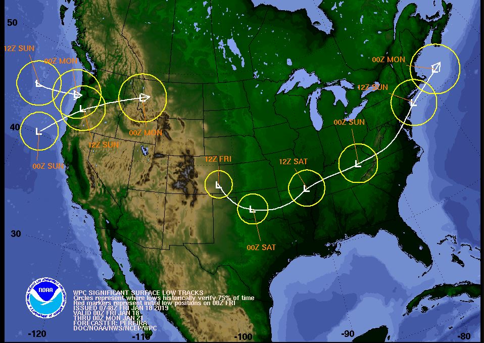
Very interesting projections from the NWS
Projected Low Tracks and their Clusters.
https://www.wpc.ncep.noaa.gov/wwd/winter_wx.shtml (Scroll to the bottom of the page)


https://www.wpc.ncep.noaa.gov/wwd/winter_wx.shtml (Scroll to the bottom of the page)

How much snow will we get tomorrow?
No one knows! This storm will be talked about for a long time from now. It's an extremely complicated setup. I've seen computer models that say that we get nothing but clouds, or that we get rain or that we get ice or that we get anywhere from 2 - 6 inches of snow. Everything is still on the table. The frustration with this storm in resulting in some anger and some humor so please be patient.
My best guess is we start out with rain and then transition to ice and then transition to snow with a total of about 3 inches.


My best guess is we start out with rain and then transition to ice and then transition to snow with a total of about 3 inches.


Looks like the NWS confirms.
It looks like the National Weather Service has confirmed my prediction. Winter Storm Watches have been issued in all counties north of Monroe County but not including Monroe County. I think we are right on the rain / snow line. We'll likely see rain and snow mixing with sleet with an accumulation of about 3 to 3.5 inches.
Bloomington Indiana right on the line.
As you might have heard, a snowstorm is coming on Saturday. It looks like Bloomington is right on the freezing line. All points north should see some accumulating snow with the heaviest band being across Indianapolis. South of Bloomington should see mostly rain. In out area the primary threat is going to be a wintry mix.

People on twitter are using the "B" word.
It's way too early to talk about a Blizzard. Sure, the ingredients are all on the table but exactly where is anybody's guess from this far out.


NWS Special Wx statement on upcoming weekend.
Special Weather Statement
National Weather Service Indianapolis IN
241 PM EST Mon Jan 14 2019

INZ021-028>031-035>049-051>057-060>065-067>072-150745-
Carroll-Warren-Tippecanoe-Clinton-Howard-Fountain-Montgomery-
Boone-Tipton-Hamilton-Madison-Delaware-Randolph-Vermillion-Parke-
Putnam-Hendricks-Marion-Hancock-Henry-Vigo-Clay-Owen-Morgan-
Johnson-Shelby-Rush-Sullivan-Greene-Monroe-Brown-Bartholomew-
Decatur-Knox-Daviess-Martin-Lawrence-Jackson-Jennings-
Including the cities of Delphi, Flora, Williamsport,
West Lebanon, Lafayette, West Lafayette, Frankfort, Kokomo,
Attica, Covington, Veedersburg, Crawfordsville, Lebanon,
Zionsville, Tipton, Fishers, Carmel, Noblesville, Anderson,
Muncie, Winchester, Clinton, Newport, Rockville, Greencastle,
Plainfield, Brownsburg, Danville, Indianapolis, Greenfield,
New Castle, Terre Haute, Brazil, Clay City, Spencer,
Martinsville, Mooresville, Greenwood, Franklin, Shelbyville,
Rushville, Sullivan, Linton, Bloomfield, Bloomington, Nashville,
Columbus, Greensburg, Vincennes, Washington, Loogootee, Shoals,
Bedford, Mitchell, Seymour, Brownstown, and North Vernon
241 PM EST Mon Jan 14 2019

...Another Winter Storm may Impact Central Indiana this Weekend...

A Winter storm may push out of the southern plains on Friday
night and push across Kentucky on Saturday. This may result in
another significant accumulating snow for Central Indiana on
Saturday and Saturday Night.

It remains too soon to determine specific snowfall amounts.
However...current forecast models suggest accumulating snow...that
could result in snow covered roads and surfaces and difficult
travel conditions.

There is still uncertainty in the forecast. The timing and the
path of the storm could change in later forecasts. People should
stay aware of the forecast and be prepared for the possibility of
more snow on Saturday.

$$
Reports.
The official snow total for Bloomiongton Indiana was four inches. This is exactly what I measured yesterday. The NWS (National Weather Service) has a snowfall analysis website where you can search for snow totals in your area.
https://www.weather.gov/crh/snowfall
The Community Collaborative Rain Hail & Snow Network (all volunteer reporting)
https://www.cocorahs.org/ViewData/StateDailyPrecipReports.aspx?state=IN
There is snow showing up on radar in Illinois.

There's already talk of another snowstorm for next weekend. I can't believe people are already putting up snow maps this early.

LOL! Snow storm next week!
There are already posts and snow graphics going up about a snowstorm for next week and we are not even through this one yet.


9:00am Saturday Morning in Bloomington Indiana - Four inches of snow.
Not too bad. 4 inches of snow by my measurements. Nonetheless a Winter Storm Warning is still in effect until 7:00AM Sunday, January 13.


Winter Storm Warning now in effect for parts of central and southern Indiana.
#BOTS!
Congratulations #BOTS fans! (Bring On The Snow!)
I want to send a word of caution about the various snow total maps out there and especially on twitter. Personally, I would go with what the National Weather Service out of Indianapolis says as the official forecast for this storm.
The totals have risen from 4 inches to 6 inches.
The current road and surface temperatures are 37.5 degrees but that will fall as the day turns into evening.
The good news is that the snow will not start until midnight tonight so most people will be off the roads by then and this gives the salt trucks time to clean the roads.
Temperatures will return to the lower 40's next weekend (Friday, Saturday & Sunday) before the next arctic blast and the potential for another snowstorm between January 22-24th.
That's it for now. Please be safe tomorrow and check the INDOT website for travel advisories.
I'm sitting at Lucky's Market on the south side of town. People are shopping and stocking up on the necessities like wine and cheese.
Goold ol' B-town.
Winter Storm Watch issued form Monroe County Indiana
And surrounding counties too. So this is significant. The NWS has made the call so we can be certain that a sticking snow is coming. They are saying 4-7 inches. If you don't have snow scrapers and shovels, you might want to get one.

Yes, there is a strange gap in the three counties west of the state line from Vincennes to Terre Haute.
_____

Yes, there is a strange gap in the three counties west of the state line from Vincennes to Terre Haute.
_____
URGENT - WINTER WEATHER MESSAGE
National Weather Service Indianapolis IN
336 PM EST Thu Jan 10 2019

INZ043>048-051>057-060>065-067>072-111100-
/O.NEW.KIND.WS.A.0001.190112T0500Z-190113T1200Z/
Vermillion-Parke-Putnam-Hendricks-Marion-Hancock-Vigo-Clay-Owen-
Morgan-Johnson-Shelby-Rush-Sullivan-Greene-Monroe-Brown-
Bartholomew-Decatur-Knox-Daviess-Martin-Lawrence-Jackson-Jennings-
Including the cities of Clinton, Newport, Rockville, Greencastle,
Plainfield, Brownsburg, Danville, Indianapolis, Greenfield,
Terre Haute, Brazil, Clay City, Spencer, Martinsville,
Mooresville, Greenwood, Franklin, Shelbyville, Rushville,
Sullivan, Linton, Bloomfield, Bloomington, Nashville, Columbus,
Greensburg, Vincennes, Washington, Loogootee, Shoals, Bedford,
Mitchell, Seymour, Brownstown, and North Vernon
336 PM EST Thu Jan 10 2019

...WINTER STORM WATCH IN EFFECT FROM LATE FRIDAY NIGHT THROUGH
SUNDAY MORNING...

The National Weather Service in Indianapolis has issued a Winter
Storm Watch, which is in effect from late Friday night through
Sunday morning.

* TIMING...Late Friday night through early Sunday morning.

* MAIN IMPACT...Potential exists for 4 to 7 inches of snow
  accumulation, with locally higher amounts possible. This will
  create hazardous travel conditions.

* OTHER IMPACTS...Potential for low visibilities in heavy snow
  bands.

PRECAUTIONARY/PREPAREDNESS ACTIONS...

A Winter Storm Watch means there is a potential for significant
snow, sleet, or ice accumulations that may impact travel.
Continue to monitor the latest forecasts.
Beware of snow total info graphics and pictures.
Here we go again. I'm already seeing amounts for this weekend totalling well over a foot of snow. This is irrational. Here is what the NWS is saying:
 This is barely "Winter Storm Watch" criteria based on the definition.

Snow looks very likely for this weekend in Bloomington Indiana.
Good old Indiana. 58 degrees yesterday and snow this weekend. #BOTS!


And the wild swing continues. After the snow this weekend, it's back to above normal temperatures. Here's the NWS full discussion:
.SHORT TERM...(Tonight through Friday night)
Issued at 305 AM EST Wed Jan 9 2019

Models are close enough that the model blend initialization
was accepted for most items.

Clouds will linger tonight into Thursday across the northeast
forecast area, which will be impacted by flow off of Lake Michigan.
However, it looks like any snow showers will remain north of the
area.

Otherwise high pressure will build in and keep things dry with clear
to partly cloudy skies. Clouds will increase Friday ahead of an
approaching upper trough and low pressure system.

Good forcing and decent moisture will move in Friday night
with the system, and this should produce some snow for the area.
Amounts are still uncertain, as the initialization`s QPF amounts are
higher than WPC`s numbers. This is likely due to the NAM and ECMWF
being more aggressive with QPF amounts. Not sure that much moisture
will make it up here, but don`t have enough confidence to change the
initialization at this time.

MOS`s low temperatures for tonight look too cold many areas, with
some clouds and wind around. Went closer to the blend.

&&

.LONG TERM /Saturday through Tuesday Night/...

Issued at 338 AM EST Wed Jan 9 2019

The focus of the extended period remains on the Saturday snow
chances. Models are in decent agreement with a low pressure
system tracking across Missouri on Saturday, spreading a plume of
moisture ahead of it through the Tennessee Valley and into central
Indiana. The bulk of the moisture will affect the southern
portions of central Indiana with amounts in the 3 to 4 inch range,
but confidence is also low in those amounts across that area due
to rain mixing in on Saturday. Further north, amounts will be more
in the 1 to 3 inch range where precipitation will generally stay
in the form of snow, but where moisture will not be as abundant.

As the system moves eastward, snow showers will end from northwest
to southeast on Saturday night and Sunday. After that, high
pressure will result in dry conditions through the remainder of
the forecast period with temperatures slowly climbing back above
normal.
Is winter over?
No. Winter ends on March 20 so there's about two and half months left to go. So far the temperatures have been nice and above average there are signs that the pattern might change during the last week of January.
There's also talk of a snowstorm this coming Friday into Saturday but it's too early to tell. The placement and timing of storm still have to worked out. If this is a nocturnal event then we could see some snow. If it is a daytime event we'll likely see rain. The trend this year has been for us to be on the warm side of the storm which means rain. The other trend has been suppression of storms to our south as we get closer to the event.
Here are some things to keep in mind as we head through January:
The old southeast ridge.

Sudden Stratospheric Warming took place in the end of December. This can send polar air southwards but it might go towards Europe rather than the US.
The National Weather Service see a drier pattern in the extended period. Sorry BOTS fans.
.LONG TERM /Thursday through Sunday Night/...

Issued at 330 AM EST Mon Jan 7 2019

Below normal temperatures will persist through Thursday with
decent northwest flow around a ridge of Canadian high pressure.
The normal/above normal temperatures will return by the weekend
though as the wind shifts ahead of an upper low on Friday. This
low will also be responsible for light rain and snow showers at
times from Friday night through Saturday. Little to no snow
accumulation is expected though. After that, a dry pattern will
resume again through the remainder of the extended period. Latest
blended initialization handled the pattern well, so no changes
were needed.
Which means be very suspicious of snow prediction graphics that you see on the internet.

Subscribe to:
Posts (Atom)