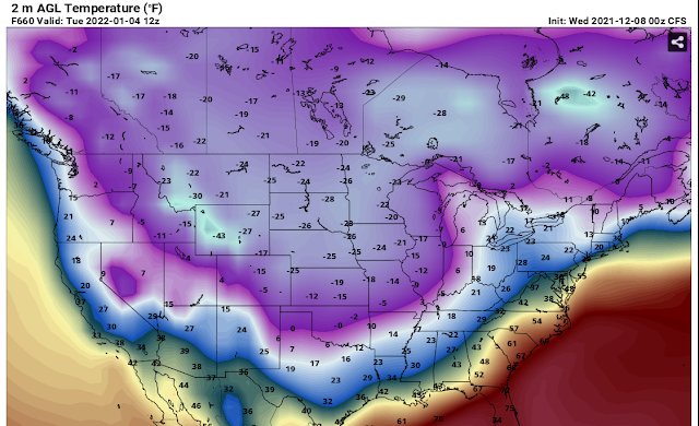
Will we go from record warmth to record cold in one month? Check out this 2M air temperature from the CFS for January 25th. This is a long way off from now so it can't be trusted but it gives you an idea of what one model is thinking.

Will we go from record warmth to record cold in one month? Check out this 2M air temperature from the CFS for January 25th. This is a long way off from now so it can't be trusted but it gives you an idea of what one model is thinking.
Issued at 300 PM EST Tue Dec 28 2021

Thursday Through Thursday Night.

Rain will come to an end across central Indiana late Wednesday night
as the forcing associated with an 850 to 700mb jet exits the area.
Dry weather then briefly returns for Thursday but with the polar air
locked well into Canada, temperatures look to remain well above
average.  Model soundings still show moderate saturation at the mid
levels, so expect at least partly cloudy skies to continue through
the overnight hours before the thicker clouds arrive Friday.

Friday Through Tuesday.

The next rain producing system will move out of the Southern Rockies
and track to the northeast Thursday into early Friday with
precipitation for central Indiana beginning Friday afternoon.
Confidence in the track of the low has increased but there remains
many of the mesoscale features that remain uncertain that will
impact the axis of heaviest rain or the threat for thunderstorms.
Current thoughts are the axis of heaviest precipitation will be
south of the Ohio River with northerly surface flow across much of
the area. This will keep central Indiana out of the warm sector and
keep thunder or strong storm threats to near zero.

If the track inches northward a bit, the southern counties could see
a few thunderstorms. A weak TROWAL may allow for some snow to mix
into the northern counties Saturday into early Sunday after the
initial round of rain, but confidence in both the strength of the
TROWAL and how could the airmass is are both low at this time. High
pressure and seasonable weather then arrives Monday into Tuesday as
high pressure builds across the area.

I respect the National Weather Service. They are professionals. I've met some of them and shook their hands (long before the pandemic). They do excellent work. The information that they provide for free is highly invaluable to those who can't afford the latest model of a smart phone and a subscription to a paid weather app. If you want to purchase a weather app or if you want to sell a weather app subscription service, then fine. But this; this slamming of the National Weather Service is not necessary.

There's evidence that cold air will build into Canada in January. The main questions is, will any of it spill southward into the USA? Perhaps it will stay bottled up in Canada. If it does, that means the warmer weather will continue through January. These kinds of things are hard to predict but take a look at these longe range computers runs by the CFS. Notice the time and date stamp and the -40 degree temperatures in Canada.


More life threatening and damaging tornadoes off to our west tonight. If you have family members in this area, warn them now!

8 feet of snow in California and not Buffalo New York.
https://www.usatoday.com/story/news/nation/2021/12/14/powerful-storm-lashes-california-rain-wind-snow/8895250002/
8 miles of frozen river in Maine has caused an ice jam.
https://weather.com/safety/winter/video/maine-river-clogged-by-miles-long-ice-jam
That describes the weather for the next ten days to two weeks but if you want the real recipe, see below. Nonetheless, everything is on the table including rain, strong storms, wind, fog, snow, high temperatures in the 60's and low temperatures in the 20's. The good news is that the hint of strong storms showing up will not be severe, just noticeable. Real Winter is still on hold until January. The CFS has backed off on the extreme cold but it's still there.
Thursday 11/16/21


1 pound lean ground meat, such as hamburger, elk, or turkey
2 medium or one giant onion, diced
4 cloves garlic, minced
2 cups cooked brown lentils
2 cups cooked black beans
1 small zucchini, quartered and sliced2/3 cup chopped celery (about 2 large celery ribs) 2 cups frozen corn
2 cups kale or spinach
4-6 potatoes, sliced thin
1 cup a blend of uncooked rice (wild rice and long grain white rice work great)1 1/4 cup green beans (chopped, ends removed)4 ounces pancetta or chopped uncured bacon2 cups shredded cabbage
1 medium zucchini, quartered and then sliced
1 quart whole tomatoes, about 4 cups (if you don’t bottle at home, store-bought whole or diced tomatoes work well too)
1 quart broth
1 T. fresh chopped rosemary
1 T. fresh chopped thyme
2-3 T. fresh chopped basil
1/4 cup fresh chopped parsley
1 T. salt
1 tsp. black pepper
In a skillet cook the ground meat, onion, and garlic until the meat is cooked through and no longer pink. Add the meat mixture to a large 6-quart crock pot. Add all of the other ingredient. While you are pouring the tomatoes in, crush them with your hands before they fall into the crock pot. Place the lid on the clock pot and cook for 6-8 hours on low or 4-6 hour on high. If you aren’t a crock-potter just cook the meat in a large stock pot and add everything to when the meat is cooked through. Let it simmer on the stove for 45 minutes to an hour. Add salt and pepper to taste and serve with hot bread.
Notes:
This makes a huge batch of soup. I froze half of it for a second easy meal and then just let it thaw in my fridge overnight when I was ready to use it.
Don’t have all those fresh herbs? Dried will work fine too, just use about half as much dried and then test for taste a few hours into cooking.
This soup is super forgiving. The tomatoes, broth, and herbs are the base but you can swap/add/remove just about anything you like to suit your tastes. It’s a great recipe to start with and make your own.
Yes, unfortunately this is true. It's rare but it can happen and it has happened before. The last time this happened was back in 2015.


Area Forecast Discussion
National Weather Service Indianapolis IN
645 AM EST Fri Dec 10 2021

...Updated Aviation Discussion...

.Short Term...(Today through Saturday)
Issued at 321 AM EST Fri Dec 10 2021

...SEVERE WEATHER RISK late tonight into early Saturday...

Early this morning... Stratus clouds have continued to lift north of
the area, which allowed areas of dense fog to steadily expand in
coverage across much of Illinois into Central/Northern Indiana.
Observations have been fluctuating between near 1/8 of a mile to a
couple miles, but the trend has been steadily down. This will likely
result in a need for an early morning Dense Fog Advisory, which
given the lack of mixing and trapped moisture, any dense fog that
does develop could be slow to erode.

Warm frontal boundary continues to lift north across the region,
which can easily be found where Td`s climb to around 50 degrees.
Which is very anomalous for early Dec.

Focus for the remainder of the day will continue to be on the
impending severe weather, timing/coverage along with expected
hazards. There hasn`t been much change in the forecast approach the
last 24 hours. The one focus that has changed is the coverage of the
slight risk has shifted further north, along with an expansion to
the enhanced risk by the SPC. (spc.noaa.gov/products/outlook/)

Trough axis will continue to deepen, which will lead to further
amplification of the overall wave. Additionally, northern stream cold
pool will create a very sharp baroclinic zone across the Northern
Plains later today. As these two systems progress eastward, the
surface low will continue to deepen as it quickly lifts across the
Missouri Valley towards the Chicago area tonight.

The challenges for late fall/winter systems is generation of typical
large CAPE, or the convective potential energy; however, what does
typically occur in these very dynamical setups is abundant shear
with considerable low-level moisture. Couple this with very robust
llvl jet of 60-70kts in the 850-825mb range, thus the atmosphere
will not need an abundance of CAPE to generate convection. In
addition to the aforementioned elements, which are only a portion of
the atmospheric setup, temperatures are poised to rapidly rise
throughout the day but more so late afternoon and evening. Current
guidance suggests temps will peak late this evening in the mid 60s,
coupled with a moisture rich environment and dewpoints equally in
the upper 50s to lower 60s.

Timing for the convective initiation continues to be focused on the
arrival of a very potent speed-max of 100kt around 500mb. This will
create the trigger, interacting with the moisture rich and extremely
sheared low-levels across the Tennessee Valley/Ohio Valley, and
likely linger well past midnight for the region, before a dry nose
begins to arrive around 6-9Z Sat.

As for the focus on storm mode: At the onset it still appears to be
more cellular; however, guidance continues to indicate steady upward
growth into more linear pieces or also known as QLCSs, carrying a
risk for damaging winds and possibly even an isolated tornado.
Directional shear continues to be more uniform in the lowest 1km;
however, speed shear is potent near 40-50kts. Coupled with shallow
LCLs, and the risk for tornadoes remains present especially in any
linear segments.

Area of greatest concern: With the minor adjustment from the SPC and
inclusion of an enhanced risk, the focus continues to be on the
Western TN/KY area stretching north into Central Indiana.


If you take a look at the radar you see one thing but if you take a look outside of your window you don't see anything. It seems that the air is too dry and the snow is not making it all the way to the ground because it is evaporating.


When the red and green line are touching, it means the atmosphere is saturated. When they are far apart, the atmosphere is dry. The two yellow numbers and lines indicate where snowflakes form way up above our heads. Just as it is forming, the atmosphere dries out right below it, hence, evaporation and no snow.
Wooo hooo! It's not much but it's something given the overall warm pattern and yes, we will be back up to 65 degrees by Friday so enjoy tomorrow night.
Special Weather Statement
National Weather Service Indianapolis IN
254 PM EST Mon Dec 6 2021

INZ021-028>031-035>049-051>057-060>065-067>072-071000-
Carroll-Warren-Tippecanoe-Clinton-Howard-Fountain-Montgomery-
Boone-Tipton-Hamilton-Madison-Delaware-Randolph-Vermillion-Parke-
Putnam-Hendricks-Marion-Hancock-Henry-Vigo-Clay-Owen-Morgan-
Johnson-Shelby-Rush-Sullivan-Greene-Monroe-Brown-Bartholomew-
Decatur-Knox-Daviess-Martin-Lawrence-Jackson-Jennings-
Including the cities of Delphi, Flora, Williamsport,
West Lebanon, Lafayette, West Lafayette, Frankfort, Kokomo,
Attica, Covington, Veedersburg, Crawfordsville, Lebanon,
Zionsville, Tipton, Fishers, Carmel, Noblesville, Anderson,
Muncie, Winchester, Union City, Farmland, Parker City, Clinton,
Fairview Park, Rockville, Montezuma, Rosedale, Greencastle,
Plainfield, Brownsburg, Danville, Indianapolis, Greenfield,
New Castle, Terre Haute, Brazil, Spencer, Gosport, Martinsville,
Mooresville, Greenwood, Franklin, Shelbyville, Rushville,
Sullivan, Carlisle, Shelburn, Farmersburg, Linton, Bloomfield,
Jasonville, Worthington, Bloomington, Nashville, Columbus,
Greensburg, Vincennes, Washington, Loogootee, Shoals, Bedford,
Mitchell, Seymour, and North Vernon
254 PM EST Mon Dec 6 2021

...LIGHT ACCUMULATING SNOW TUESDAY NIGHT...

An upper level disturbance will track across the region Tuesday
night...bringing a period of light snowfall from Tuesday evening
through the predawn hours Wednesday. Snow accumulations will be
light...with most locations seeing a half inch to one inch by
Wednesday morning. A few spots may see slightly higher amounts.

The timing of the snowfall along with it being the first
widespread accumulation of the season will likely produce higher
impacts to travelers early Wednesday...especially during the
morning commute. Be prepared for icy spots on roads...bridges and
overpasses. Untreated roads may be snow covered as well.
Bundle up.

Temperatures will recover slightly into the afternoon before the
drop off resumes into tonight. The presence of strong cold advection
will limit any temp rises from this point this morning to 2-3
degrees at best. Continued gusty westerly winds peaking up near
30mph this afternoon will keep wind chills in the 20s at best.
There's a lot of chatter on Twitter about a snowstorm next week. It's way too early to discuss this so be careful when you see images forecasting large amounts of snow. Here are the images posted on Twitter:


Here is what the National Weather Service is saying:
.Long Term...(Friday through Wednesday)
Issued at 312 PM EST Wed Dec 1 2021

Mild Weather Continues this Weekend....

Westerly WAA over the short term will help build a broad ridge over
the southern CONUS, keeping the polar jet north of central Indiana.
This will allow for a warmer than normal temperatures to continue
through the weekend. Friday will be 10-15 degrees warmer than
average as a weak wave within the low level flow will back surface
winds to the SW, advecting even warmer air into the region. Some mid
level clouds will be possible on Friday given the passage of the
wave, but surface moisture return will be insufficient for any low
level clouds or precipitation to occur. There is some uncertainty on
afternoon highs for Friday given increased cloud cover. Current
expectations are for most locations along and south of I-70 to reach
60 with mid 60s possible in far SW central Indiana.

Near zonal flow aloft and weak low level disturbances will continue
to have marginal impacts on Saturday and Sunday. Low level winds
will shift back towards the NW for Saturday, dropping highs around
10 degrees. Skies will clear on Saturday though within broad
subsidence as the low level ridge axis passes through central
Indiana. By Sunday, the ridge will be east of central Indiana, once
again placing the region in predominant SW flow. Temperatures should
spike back into the mid to upper 50s for Sunday. This SW flow will
also be upstream of a stronger cyclone over the plains.


Precipitation Possible Early next Week...

Weather will become more active early next week, as two more
amplified troughs approach from the NW. The first chance of
precipitation will be late on Sunday into Monday morning.
Significant moisture return within strong SW flow will push Pwat
values above seasonal. This along with broad vertical lift should be
enough for scattered showers to develop. This should be east of the
region by Monday morning, although ensemble members are still varied
on overall timing for this event.

The next wave looks to move through Tuesday into Tuesday night. This
wave should be attached with cold Canadian air and interact with
leftover moisture from the initial wave. This will lead to snow on
the cold side of the system. Where this low will track is still
widely varied, but there is a chance of snow Tuesday night.
Confidence in possible snow amounts are still too low to provide
value to the forecast at this time.