Update for Thursday 4/28/16.
More rain is coming this weekend. A week from today on Thursday May 5th we will see a cold shot of air with highs in the 60's and lows in the 40's.
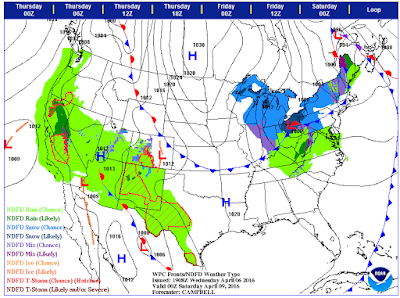
Wednesday 4/27/16 Discussion
From Indy NWS office:

Radar images:

SYNOPSIS...
ISSUED AT 347 AM EDT WED APR 27 2016

SHOWERS AND EMBEDDED THUNDERSTORMS WILL ONCE AGAIN INCREASE ACROSS
THE REGION LATER TODAY AND TONIGHT AS A FRONTAL BOUNDARY REMAINS
ACROSS CENTRAL INDIANA. ADDITIONAL STORMS ARE POSSIBLE THURSDAY AS
LOW PRESSURE TRACKS INTO THE AREA. DRY WEATHER IS EXPECTED FRIDAY
BEFORE RAIN AND STORMS RETURN FOR THE WEEKEND AS ANOTHER LOW
PRESSURE SYSTEM TRACKS THROUGH THE OHIO VALLEY.
Wednesday surface map:

Radar images:

Round two?
I'm still shocked by yesterday's pop-up tornado warning. I don't think we will see that today as dew points in the area are in the low 50's.
The local Herald Times reported that:
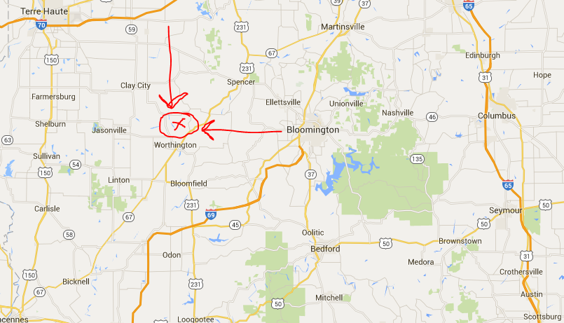
"The National Weather Service reported a tornado was spotted on the ground at 4340 North County Road 475 West in Worthington at 7:24 p.m. Tuesday."
That would be near here:

The local Herald Times reported that:
"The National Weather Service reported a tornado was spotted on the ground at 4340 North County Road 475 West in Worthington at 7:24 p.m. Tuesday."
That would be near here:
Tornado Sirens have ended (7:58pm)
The sirens have ended for now but we are not out of the woods yet. A Flood Warning has been posted for Monroe County Indiana until 10:30pm.
Tornado Sirens now in Bloomington, Indiana Tuesday 4/26/16 @7:50pm

Storm relative confirms. Heavy downpours and lightening at Starbucks on South Walnut.

Tornado Warning for Monroe County Indiana!
Hmmmpf! I'm somewhat shocked by this! From the NWS Indy office:
______________
______________
TORNADO WARNING
INC055-105-119-270000-
/O.NEW.KIND.TO.W.0003.160426T2325Z-160427T0000Z/

BULLETIN - EAS ACTIVATION REQUESTED
TORNADO WARNING
NATIONAL WEATHER SERVICE INDIANAPOLIS IN
725 PM EDT TUE APR 26 2016

THE NATIONAL WEATHER SERVICE IN INDIANAPOLIS HAS ISSUED A

* TORNADO WARNING FOR...
  NORTHEASTERN GREENE COUNTY IN SOUTHWESTERN INDIANA...
  SOUTHEASTERN OWEN COUNTY IN WEST CENTRAL INDIANA...
  SOUTHWESTERN MONROE COUNTY IN SOUTH CENTRAL INDIANA...

* UNTIL 800 PM EDT

* AT 724 PM EDT...A CONFIRMED TORNADO WAS LOCATED NEAR
  BLOOMFIELD...OR 24 MILES WEST OF BLOOMINGTON...MOVING EAST AT 25
  MPH. AT 722 PM EDT...THE PUBLIC REPORTED A TORNADO ON THE GROUND 1
  MILE SOUTWEST OF WORTHINGTON.

  HAZARD...DAMAGING TORNADO.

  SOURCE...PUBLIC CONFIRMED TORNADO.

  IMPACT...FLYING DEBRIS WILL BE DANGEROUS TO THOSE CAUGHT WITHOUT
           SHELTER. MOBILE HOMES WILL BE DAMAGED OR DESTROYED.
           DAMAGE TO ROOFS...WINDOWS...AND VEHICLES WILL OCCUR.  TREE
           DAMAGE IS LIKELY.

* THE TORNADO WILL BE NEAR...
  FREEDOM AROUND 745 PM EDT.
  SOLSBERRY AROUND 750 PM EDT.
  MCCORMICKS CREEK STATE PARK AROUND 800 PM EDT.

PRECAUTIONARY/PREPAREDNESS ACTIONS...

TO REPEAT...A TORNADO IS ON THE GROUND. TAKE COVER NOW! MOVE TO A
BASEMENT OR AN INTERIOR ROOM ON THE LOWEST FLOOR OF A STURDY
BUILDING. AVOID WINDOWS. IF YOU ARE OUTDOORS...IN A MOBILE HOME...OR IN
A VEHICLE...MOVE TO THE CLOSEST SUBSTANTIAL SHELTER AND PROTECT
YOURSELF FROM FLYING DEBRIS.

&&

Of climate science and "feminist glaciology".
This has been making the rounds. Very interesting questions for those interested in history, philosophy of science, climate science and gender studies. I wish Thomas Khun was available for comment on this.
http://phg.sagepub.com/content/early/2016/01/08/0309132515623368.abstract
http://www.sciencemag.org/news/2016/03/qa-author-feminist-geology-study-reflects-sudden-place
http://phg.sagepub.com/content/early/2016/01/08/0309132515623368.abstract
http://www.sciencemag.org/news/2016/03/qa-author-feminist-geology-study-reflects-sudden-place
Tuesday 4/26/16 Update
Current temperature is 83 degrees. The dew point is 61. A severe thunderstorm watch is in effect until 11:00pm tonight for southern Indiana.
There is a strong bow echo forming over the St. Louis area.


There is a strong bow echo forming over the St. Louis area.


Tornadoes possible tomorrow in the great plains states.
Oklahoma, Kansas and Nebraska are facing a severe weather threat for Tuesday 4/26/16. Southern Indiana is in the marginal risk zone.
Smooth sailing.
The last two week have been fabulous. Expect more of the same. Highs in the 70's and lows in the 50's with intermitant thunder storms and showers.
4/8/16 Graupel in Bloomington, Indiana at 34 degrees.
The roof tops were slightly covered before 8:00am but as the temperatures rose the graupel melted.


The first picture shows the bank tower temperature of 35 degrees. The second picture shows graupel on the windshield of the car. The third video clip is of two small graupels falling. If you watch carefully, you can see them.


The first picture shows the bank tower temperature of 35 degrees. The second picture shows graupel on the windshield of the car. The third video clip is of two small graupels falling. If you watch carefully, you can see them.
This Grateful Dead song is apt for Friday!
Cold rain and snow.
4/6/16: Today there is a wind advisory. Rain is likely tonight. A 996Mb low is located over eastern Michigan and tracking east-north east. This will drag down a cold front behind it. Temperatures and precipitation will vary over the next five days so dress appropriately. There is a 40% chance of a rain/snow mix on Friday. Not a big deal but it should be mentioned. We will be in a see-saw pattern for the next week to ten days. Here are some interesting things to look at:


4/6/16: Today there is a wind advisory. Rain is likely tonight. A 996Mb low is located over eastern Michigan and tracking east-north east. This will drag down a cold front behind it. Temperatures and precipitation will vary over the next five days so dress appropriately. There is a 40% chance of a rain/snow mix on Friday. Not a big deal but it should be mentioned. We will be in a see-saw pattern for the next week to ten days. Here are some interesting things to look at:


Subscribe to:
Posts (Atom)