I wonder if there are any #BOTS fans in Montana? Snow in mid June; how cool is that?
For Wx nerds and model watchers.
The new GFS is finally official according to the NWS. From the Washington Post:
National Weather Service launches upgraded, improved global forecast model
So, in short, the old GFS is now called "GFS Legacy" and the new GFS is called "GFS" or "GFS-FV3".
National Weather Service launches upgraded, improved global forecast model
So, in short, the old GFS is now called "GFS Legacy" and the new GFS is called "GFS" or "GFS-FV3".
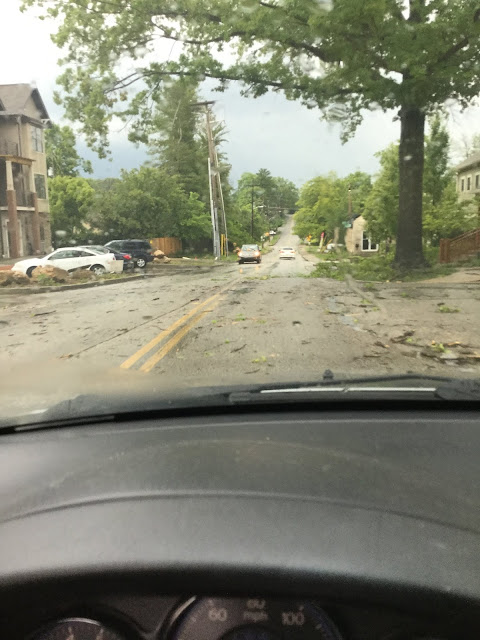
What a wild day yesterday was!
The radar lit up shortly after 6:30pm yesterday and then we were hit with strong winds and heavy rain. Here are some pictures from the south side of town.
The Herald Times online has a great story and several pictures about yesterday's storms. Due to copyright issues, I can't post those here but you can go to the link and read the story for yourself.
https://www.hoosiertimes.com/herald_times_online/free_access/tornado-destroys-monroe-county-homes/article_4eca468d-920b-57fb-b54b-8eb0a47d473d.html
According to the newspaper, the heaviest and most destructive damage was around this area:
I hope the new Cedar Ford Covered Bridge is fine. It's just southeast of the Beanblossom Bottoms Nature Preserve.
A tornado watch is in effect until 10:00PM
TORNADO WATCH OUTLINE UPDATE FOR WT 360
NWS STORM PREDICTION CENTER NORMAN OK
245 PM EDT SAT JUN 15 2019

TORNADO WATCH 360 IS IN EFFECT UNTIL 1000 PM EDT FOR THE
 FOLLOWING LOCATIONS

INC005-013-021-027-031-037-051-055-059-063-065-071-077-079-081-
083-093-097-101-105-109-117-119-121-125-133-139-143-145-153-165-
167-175-160200-
/O.NEW.KWNS.TO.A.0360.190615T1845Z-190616T0200Z/

IN
.    INDIANA COUNTIES INCLUDED ARE

BARTHOLOMEW          BROWN               CLAY
DAVIESS              DECATUR             DUBOIS
GIBSON               GREENE              HANCOCK
HENDRICKS            HENRY               JACKSON
JEFFERSON            JENNINGS            JOHNSON
KNOX                 LAWRENCE            MARION
MARTIN               MONROE              MORGAN
ORANGE               OWEN                PARKE
PIKE                 PUTNAM              RUSH
SCOTT                SHELBY              SULLIVAN
VERMILLION           VIGO                WASHINGTON
What a cool morning!
It was 49 degrees last night and it looks like it will be 49 degrees on Thursday night as well. This will be a great week to get out and enjoy yourself. Here's the detailed forecast for the rest of the week:
.SHORT TERM /Tonight through Thursday Night/...

Issued at 240 AM EDT Tue Jun 11 2019

Dry weather is expected to persist tonight and fro much of
Wednesday. The GFS and NAM both suggest the large area of surface
high pressure will take its time passing east of Central Indiana.
GFS and NAm both suggest a continued dry column tonight through at
least 18Z Wed. Thus will continue the trend of partly cloudy skies
and a blend on temps.

A stronger upper trough is suggested by the models to begin to
influence Central Indiana on Late wednesday afternoon and THursday
as it drops southeast out of the upper midwest. Forecast soundings
imply deep moisture arriving by 06Z Thursday...persisting through
the overnight Hours as the trough axis aloft passes across the
Indiana. Again forcing seems quite favorable given the suggested
upper pattern. Pwats are suggested to only reach around 1
inch...thus for this time of year...precip will be mainly light.
Will trend pops upward in on Wednesday afternoon with best chances
overnight. Given the lack of gulf flow into the Ohio valley
preceding this system...confidence on rain is medium and will
stick close to the NBM pops.

As the trough axis is departs on Thursday...forecast soundings
begin a dry out within the column as subsidence once again
resumes. Cyclonic flow looks to remain within the lower levels on
thursday afternoon...which could keep some strato-cu across the
area...but limited moisture should prevent showers. Dry weather on
Thursday night as another large and strong high pressure system
arrives from the west.

&&

.LONG TERM /Friday through Monday Night/...

Issued at 337 AM EDT Tue Jun 11 2019

The extended period will initially start out dry on Friday.
However, the pattern will quickly change by Friday night as
showers and thunderstorms enter from the west with the next
frontal system. This system will keep shower and thunderstorm
chances in the forecast through the weekend. Further out, an upper
low from the southwest will quickly follow on Monday behind the
aforementioned frontal system. So, additional showers and
thunderstorms will be possible on Monday and Monday night.
Meanwhile, temperatures will start out below normal early in the
period, then quickly return to normal/slightly above normal by
the weekend.
Subscribe to:
Posts (Atom)


