
2/29 Winter slowly winding down
It's another beautiful day in Btown. Some light rain/snow mix Tuesday night into Wednesday and then a warming trend.

Friday 2/26
What a nice day! Even nicer on Saturday and Sunday. Sunday's high is 63. Snow is possible next Wednesday 3/2 into Thursday 3/3.
What's up with the March 2-4, 2016 event?
The answer is, we don't know. It's ten days away. Social media is wreaking havoc on weather forecasting. Remember, the indices drive the pattern, not the other way around. Always look at your current conditions and the indices first.

 After looking at the indices you can get an *idea* about what *might* happen but the confidence level on that would be very low. Next, the storm needs to be sampled.

After that, you can start analyzing models for consistency.
GFS

JMA

GEM

The most reasonable conclusion that can be drawn is that a trough will dig in somewhere in the middle of the country.


After that, you can start analyzing models for consistency.
GFS

JMA

GEM

The most reasonable conclusion that can be drawn is that a trough will dig in somewhere in the middle of the country.
Wednesday 2/24 4:55pm
Warnings and advisories are beginning to expire out to our west. Not everyone got snow and not everyone saw snow but it was still a large and impressive system. It touched Michigan and Georgia and many points in between.
The barometric pressure got as low as 992.1 Mb or 29.28 In.

It looks like we will repeat this again. Highs in the 60's by Sunday 2/28 and snow again by Thursday, March 3rd.
The barometric pressure got as low as 992.1 Mb or 29.28 In.

It looks like we will repeat this again. Highs in the 60's by Sunday 2/28 and snow again by Thursday, March 3rd.


Wednesday 2/24 10:30AM Low Pressure of 992 Millibars
This is the kind of low that could cause a little joint pain if you are sensitive to pressure.


Bloomington will be right on the rain / snow line.
Wednesday 2/24 will start with rain and transition to wet slushy snow overnight. I don't see very much in the way of accumulation unless the track of the low shifts. That is possible. Winter storm warning are being posted through the state of Michigan right now. Advisories and warning for northern Indiana will be likely later today.


72 Degrees to snow by Thursday?

Rain changes over to snow showers Wednesday 2/24 into Thursday 2/25. Nothing big for Bloomington so don't believe the hype.

Tuesday 2/16
Some sunshine today and the high temperature has already exceeded the forecast high. Yes, that happens from time to time especially with aggressive snow melt. The current high temperature is 41 degrees while the forecast high was 39 degrees.
 Temperatures will likely go up and down and then up and down again for the next two weeks. Here is sneak preview.
 Here's more on that:

 Other than this, there's nothing of interest showing up on the long range models and we don't trust those anyway so enjoy a nice week. Temperatures will be in the 60's by Friday.


2/15/16 A gray day in B-town.
It's 36 degrees and foggy and misty and gray. Rain and snow are passing over Kentucky. We should be fine. Madison, Indiana could get in on some wet snow. Tomorrow's high temperature is 37 with a 30% chance of a rain-snow mix. After that it warms up.
Saturday musings.
There's a lot of upset people on social media, especially #BOTS fans. Some people thought we were going to get a big snowstorm and now reality is setting in. This is exactly why you don't trust long range models. If you've read this blog from day one, you already know that I have mentioned the three-day rule. Weather and stock markets have a lot in common. In the financial markets there are those who ignore fundamentals like the inverse relationship between stock and bonds. Those people are called "technicians". They only look at computer models and algorithms.The same applies here. Weather forecasting has a lot of fundamentals to understand than include many measurements, variables and pattern changes. These are the fundamentals. The other people, (lets call them weather technicians) just look at computer models. While both are helpful, you can't look at the technical side without paying attention to the fundamentals. That same is true for weather, finance and perhaps a few other subject areas. Nonetheless, winter is not over.
Saturday 2/13/16.
At 11:30am it was 14 degrees with sunny skies in Bloomington. The Sunday into Monday system has finally been sampled. So far, this does not look like a phased system. This is looking like a two part system. Part one happens tomorrow as snow arrives from the north west into central Indiana as clipper. Part 2 happens as low develops over Texarkana area and heads east. The second low looks to stay south of here as it move from Texarkana to the outer banks of North Carolina. There will be a few minor troughs and disturbances moving through Tuesday into Wednesday. After that we warm up. Temperatures near 60 by Friday 2/19.
Winter weather advisories are posted right up to Illinois / Indiana border. I expect that to move eastward later to today. After all is said and done, we are looking at 2-4 inches on this system with minor accumulations Tuesday and Wednesday.

Winter weather advisories are posted right up to Illinois / Indiana border. I expect that to move eastward later to today. After all is said and done, we are looking at 2-4 inches on this system with minor accumulations Tuesday and Wednesday.

Friday 2/12/16 Update 3
@ 1:35pm You can see some very light snow flurries in the downtown Bloomngton area.
Friday 2/12: The Latest NWS Discussion
Forecast Discussion for our area:
A LOT OF MOVING PARTS IN REGARDS TO THE EARLY WEEK SYSTEM POISED
TO AFFECT THE EASTERN U S AND THE 00Z MODEL SUITE DID LITTLE TO
INCREASE THE LOW CONFIDENCE IN HIGHLIGHTING SPECIFIC IMPACTS TO
CENTRAL INDIANA. THE EXTENDED PERIOD WILL BE ACTIVE WITH VARIOUS
SNOW THREATS THROUGH MIDWEEK BEFORE A WARMING TREND COMMENCES FOR
THE SECOND HALF OF THE WEEK.

NORTHERN STREAM CLIPPER SYSTEM WILL SWING THROUGH THE LOWER GREAT
LAKES LATE SUNDAY AND EARLY MONDAY AND WILL PRESENT CHANCES FOR
SNOW. AT THE SAME TIME...LOW PRESSURE ORGANIZING OVER THE LOWER
MISSISSIPPI VALLEY WILL TRACK NORTHEAST INTO THE LOWER APPALACHIANS
BY TUESDAY. ADDITIONALLY...OP GFS AND ECMWF BOTH TRACK ANOTHER
CLIPPER INTO THE MID MISSISSIPPI VALLEY. THE 00Z RUNS OF THE
OPERATIONAL MODELS ARE TRACKING THE MAIN SYSTEM EAST OF THE
APPALACHIANS AND ARE SUGGESTIVE OF LESS OF AN IMPACT TO THE REGION
WITH NO PHASING WITH THE CLIPPER TO THE NORTHWEST. GFS ENSEMBLE
MEMBERS ON THE OTHER HAND ARE ALL OVER THE PLACE WITH THE SURFACE
LOW TRACK DUE TO VARYING DEGREES OF PHASING IN THE UPPER LEVELS.
FURTHER MUDDYING THE WATERS IS THE MARGINAL TEMPS IN THE NEAR
SURFACE LAYER WHICH ARGUES FOR EVEN THE POSSIBILITY FOR OTHER PRECIP
TYPES TO MIX IN WITH SNOW FOR A TIME ON MONDAY AND TUESDAY.

THE UPPER LEVEL FLOW AND TELECONNECTION PATTERN SUGGESTS
POTENTIAL IS THERE FOR SOME SHIFT NORTH AND WEST TO THE MAIN
SYSTEM. WITH THE PRIMARY UPPER WAVE STILL OUT OVER THE PACIFIC AND
NOT FULLY SAMPLED YET...FUTURE MODEL RUNS TODAY AND SATURDAY WILL
BE CRITICAL IN DETERMINING IF THE MAIN STORM SHIFTS LEFT AND
PRESENTS A GREATER IMPACT TO PARTS OF THE FORECAST AREA FOR EARLY
WEEK. AT THIS TIME HOWEVER...ATTEMPTING TO EMPLOY ANY DETAIL
INCLUDING POTENTIAL SNOWFALL AMOUNTS IS POINTLESS. WILL CARRY
CHANCES OF SNOW MONDAY AND TUESDAY WITH A POSSIBILITY FOR RAIN TO
MIX IN ACROSS THE SOUTH TUESDAY AS CRITICAL LOW LEVEL THICKNESSES
Friday 2/12/16
The radar showed light snow showers over Bloomington very early this morning but none of it reached ground level. The air is just too dry. At 11:00am it's 25 degrees with overcast skies. The windchill is 16 degrees. The NWS (National Weather Service) is forecasting a 60% chance of snow for Sunday night. That means snow is more likely than not. It's still to early to talk about exact amounts and the track. I would even add precipitation type too. As low pressure systems strengthen to our south west, they tend to draw in warm air ahead of the storm. That means a rise in temperatures. The current forecast high from the NWS for Monday 2/15 is 36 degrees. As you can see, that is already above freezing so if the the NWS is forecasting snow, it is likely to be that heavy wet snow rather than the fluffy softer kind. Another thing to keep in mind is that the storm has not been sampled yet. That should happen later tonight and certainly but Saturday morning. I wouldn't put any confidence in a forecast until after tomorrow morning. There are still run-to-run inconsistencies in the models with the GFS (Global Forecasting System) giving the most bizarre outputs I've ever seen. Stay tuned. The weather around here is like Schrodinger's Cat. We could get snow, we could get ice, we could get nothing if the storm tracks to our south, we could get rain if it strengthens and turns quickly to our north. Anything and nothing are all on the table until the storm gets sampled.
Thursday 2/11/16
It is cold! I woke up to a temperature of 5 degrees at 7:00AM. It's a little warmer now at 18 degrees. Model mayhem is still going on for the 2/15 system. This storm will not be sampled until Friday night or Saturday morning so trust nothing until then.
It is interesting that the GFS is hinting at the storm being s clipper or a wave that would amount to about 1-3 inches of snow. It doesn't see a storm at all. The warming trend is still on track for next week.
It is interesting that the GFS is hinting at the storm being s clipper or a wave that would amount to about 1-3 inches of snow. It doesn't see a storm at all. The warming trend is still on track for next week.
Do you want to gain insight into the meteorological mind?
One of the best ways to understand what forecasters are thinking is to follow the forecast discussions. Here is how you do that:
Go to weather.gov
Click on your state
Click on your county ( your count seat will appear which is good enough)
Scroll down to the bottom left-hand side
Click on the link for forecast discussion

Here is an excerpt:
"
Go to weather.gov
Click on your state
Click on your county ( your count seat will appear which is good enough)
Scroll down to the bottom left-hand side
Click on the link for forecast discussion

Here is an excerpt:
"
.SHORT TERM /THURSDAY THROUGH SATURDAY/...

ISSUED AT 306 PM EST WED FEB 10 2016

VERY COLD SURFACE HIGH PRESSURE WILL THEN BUILD IN FOR THURSDAY
AND KEEP CONDITIONS DRY AND COLD. SKIES WILL AVERAGE PARTLY CLOUDY FOR
THE DAY...HOWEVER PORTIONS MAY BE MOSTLY SUNNY AT TIMES.

THEN MODELS ARE PREDICTING A FASTER MOVING SHORTWAVE DIVING
SOUTHWEST ACROSS CENTRAL INDIANA BY AS EARLY AS VERY LATE THURSDAY
NIGHT. THIS FEATURE WILL HAVE THE POTENTIAL TO PRODUCE LIGHT SNOW
SHOWERS AND/OR FLURRIES DURING THE FRIDAY MORNING RUSH HOUR AND
THEN LINGER THROUGH THE LATE AFTERNOON. GUIDANCE INDICATES A LULL
IN SNOW SHOWER/FLURRY ACTIVITY FOR EARLY FRIDAY EVENING. THEN THE
UPPER LOW STRENGTHENS AND SINKS FARTHER SOUTH AND PUSHES EASTWARD
NORTH OF THE SAINT LAWRENCE RIVER VALLEY AND A FEW LAKE EFFECT
SNOW SHOWERS ARE POSSIBLE ACROSS THE FAR NORTHEAST SECTIONS OF THE
COUNTY WARNING AREA FOR FRIDAY NIGHT.

THE REST OF THIS PERIOD WILL STAY MOSTLY CLEAR AND COLD WITH
HIGHS ONLY IN THE LOW TEENS AND LOWS IN THE SINGLE DIGITS. THE
COLDEST APPARENT TEMPERATURES LOOK TO BE EARLY SATURDAY MORNING
WITH WIND CHILLS RANGING FROM AROUND -5 TO -10 FOR CENTRAL
INDIANA.

&&

.LONG TERM /SATURDAY NIGHT THROUGH WEDNESDAY/...

ISSUED AT 220 PM EST WED FEB 10 2016

THE BLENDED INITIALIZATION FROM THE REGIONAL SOFTWARE WILL BE
ACCEPTED WITH HIGH CONFIDENCE FOR SUNDAY WHEN THERE IS GOOD
CORRESPONDENCE BETWEEN VARIOUS FORMS OF GUIDANCE.

THE BLEND WILL BE USED WITH MODERATE CONFIDENCE MONDAY THROUGH
WEDNESDAY. THERE IS GOOD AGREEMENT BETWEEN THE STATISTICAL GUIDANCE
FROM THE EUROPEAN MODEL AND THE GFS. THAT BOLSTERS CONFIDENCE.
HOWEVER THERE ARE SIGNIFICANT DIFFERENCES IN THE DETERMINISTIC
FIELDS OF THE EUROPEAN AND THE GFS AS WELL AS INCREASED ENSEMBLE
SPREAD. THAT REDUCES CONFIDENCE."
Hint: Remember run-to-run consistency?
Wednesday 2/10 Update 2.
Food for thought. The Weather Prediction Center has posted these:


 So there is a 50 - 70% probability of winter precipitation in our area but the NWS (National Weather Service) is taking the storm south from Louisiana to South Carolina. A storm track from Kentucky to West Virginia would favor our area but this is not the case. This what I love about the weather.


Wednesday 2/10/16 Bloomington, IN Weather Update.
Sunny and cold. Current temperature is 17 degrees with a windchill of 3. There's still a lot of chatter about a post-Valentine's Day snowstorm but I think it's still too early to discuss that. The models have been all over the map. There are also two clipper systems to our north and west that might impact the Monday event. Another thing that I'm seeing is a progressive warming trend especially from February 17 - 19.
 The National Weather Service has a high temperature of 37 degrees for Monday 2/15 and a high temperature of 40 degrees on Tuesday 2/16. So, you can already see the warming starting to take place before we hit the 17th. Things could still change though so stay tuned. This is what happens when the NAO and the AO hug close to the zero line.

Tuesday 2/9/16 Update 2
It's 6:13pm. The snow is now sticking to the roads. You'll want to drive slowly and be safe.
Tuesday 2/9/16
Light snow showers continue in the Bloomington area. Snow showers will continue throughout the day and into this evening. We'll see a low temperature of 12 degrees tonight. It's going to be a cold couple of days. The high on Wednesday will be 19 and the high on Thursday will be 24.
Facebook and Twitter are all abuzz over a winter storm for Sunday night into Monday. I'm not sold on that idea just yet. The cold air seems to be in full retreat Sunday into Monday. Does the cold air hang around or does it move out and get replaced by warmer air?
Sunday's temperature profile

Monday's temperature profile

Monday 2/8/16
Off and on light snow showers are happening in the Bloomington area. I doubt we will see very much in the way of accumulation. I walked to a friend's house to see the Super Bowl yesterday at it was 52 degrees. Currently it's 35. The air is warn and the ground is warm also. I've seen graphics on facebook and twitter again about huge snow amounts for next Monday's (2/15) system. Beware!
Saturday 2/6/16
Great couple of days. High of 47 today and 50 tomorrow. Tomorrow night there's a slight chance (30%) of light rain. On Monday there will be snow showers off and on all day and into Tuesday. Temperatures plunge Tuesday and Wednesday with lows falling into the lower teens. Next, all eyes turn to the weekend and the *possibility* of a storm. This far out, it could be rain or it could be snow. The latest 06Z run on the GFS at 222 hrs out has 1006mb low over Oklahoma. Precipitation starts as ice and changes to snow as the low moves right over Evansville, Indiana. This is still ten days away and the track and timing will likely change. There are many questions to consider. How much of the polar vortex comes down and gives us a glancing blow? Does the west to east flow keep us warm? Where is the track? How much snow do we get Monday and Tuesday? These are all factors. Stay tuned.


Wednesday 2/3/16 Update 2.
FYI @ #BOTS! fans: There is something interesting popping up for Valentines Day; give or take a day on either side. It's too far away to even discuss right now. Stay tuned.
Wednesday 2/3/16
I hope everyone is doing well today. We received some heavy downpours at times last night. The winds were strong and gusty so there might have been a little wind damage in some areas. At 8:35PM ET, I recorded a barometric low of 29.59 inches.

 Skies are mostly clear with a temperature of 45 degrees. It's a beautiful day.

 Temperatures will fall throughout the day. The low will be 24 degrees tonight.
Enjoy.


Enjoy.
2/2/16 Update 5
There is a tornado warning two counties due south of Evansville, Indiana in the town of Madisonville, Kentucky. The dew point in Madisonville is 61.
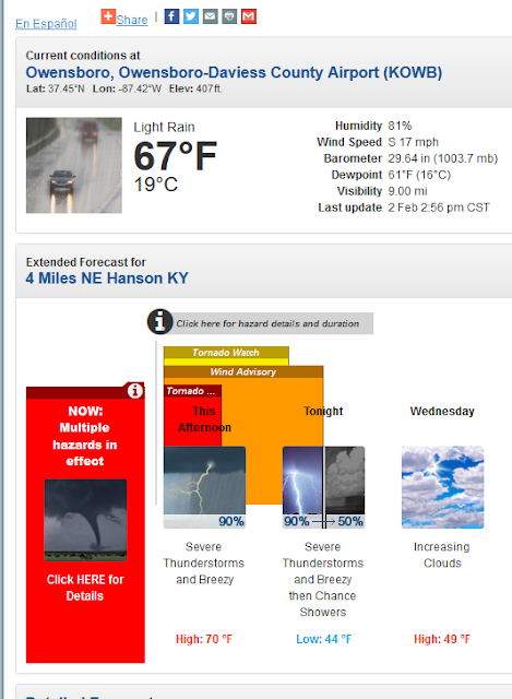

2/2/16 Update 4
A tornado was confrimed in Newton, Mississippi. The dew point there is 68.
The current dew point in Bloomington is 53.
Tornado watch areas are slowly shifting east for areas to our south.
The current dew point in Bloomington is 53.
Tornado watch areas are slowly shifting east for areas to our south.
2/2/16 Update 3.
The National Weather Service has issues a Tornado Watch for points south of here including western Kentucky, western Tennessee, and northern Mississippi. This makes sense. Check out the current dew points for selected cities as of 1:52pm today:
Bloomington 44
Evansville 54
Paducah 60
Memphis 65
Tupelo 64
Bloomington 44
Evansville 54
Paducah 60
Memphis 65
Tupelo 64

Tuesday 2/2/16
Thunderstorms tonight! Some of them may be strong or severe the farther south you go. Instability in the air aloft is going to be key. One of the criteria for tornadic activity is dew points above 60. In the winter time dew points above 50 can also count. The current dew point is 35 degrees. The higher the dew point temperature, the more moisture there is in the air.
Once we get through tonight there are clear skies ahead for the rest of the week. There will be a brief cool down Wednesday before warming up again. A high temperature of 50 degrees is possible by Sunday.
Cold air will return by next Thursday 2/11.

Once we get through tonight there are clear skies ahead for the rest of the week. There will be a brief cool down Wednesday before warming up again. A high temperature of 50 degrees is possible by Sunday.
Cold air will return by next Thursday 2/11.

Subscribe to:
Comments (Atom)