Storm Start Time?
It's 1:32pm now. The leading edge of the rain and storms should start around 2:05pm.
A tornado in Daviess County (west of Bedford)
Tornado Warning
Severe Weather Statement
National Weather Service Indianapolis IN
105 PM EDT THU MAY 31 2018

INC027-311715-
/O.CON.KIND.TO.W.0005.000000T0000Z-180531T1715Z/
Daviess IN-
105 PM EDT THU MAY 31 2018

...A TORNADO WARNING REMAINS IN EFFECT UNTIL 115 PM EDT FOR
SOUTHEASTERN DAVIESS COUNTY...

At 105 PM EDT, a severe squall line capable of producing both
tornadoes and extensive straight line wind damage was located 10
miles northwest of Jasper, or 13 miles east of Petersburg, moving
east at 55 mph.

HAZARD...Tornado.

SOURCE...Radar indicated rotation.

IMPACT...Flying debris will be dangerous to those caught without
         shelter. Mobile homes will be damaged or destroyed. Damage
         to roofs, windows, and vehicles will occur.  Tree damage is
         likely.

These dangerous storms will be near...
  Alfordsville around 110 PM EDT.
A line of storms.
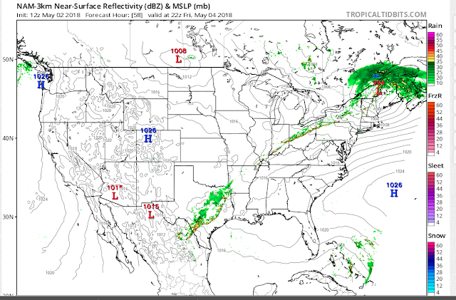
A line of storms just formed in southern Illinois and is moving in our direction. Monroe County is under a Severe Thunderstorm Watch until 6:00pm. Severe Thunderstorm Warnings are in place in southern Illinois. We'll need to pay close attention to this line as it moves through. The direction of travel is towards the north east.
The eye of the storm!
The eye of the storm is due west of Bloomington right now and it's traveling north, north-eastwards.
80% chance of rain today.
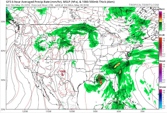
I thought we would have received more rain last night and this morning but it just didn't happen. The subtropical low or remnants of Alberto is circling over Evansville right now.
High temperatures fall into the lower to mid 80's for the rest of the week with anywhere from a 30-40% chance of storms each day. We will stay in this pattern for another week. A cool down happens on June 8 or June 9.
High temperatures fall into the lower to mid 80's for the rest of the week with anywhere from a 30-40% chance of storms each day. We will stay in this pattern for another week. A cool down happens on June 8 or June 9.
That Glenn Frey Song.
The heat is on! Expect temperatures to be in the upper 80's to 90 for the next ten days. Relief comes on June 5 or June 6. High temperatures will be in the 70's.
The first tropical storm of the season is in the gulf of Mexico. Tropical storm Alberto looks like it will impact the western panhandle of Florida by Monday.
The first tropical storm of the season is in the gulf of Mexico. Tropical storm Alberto looks like it will impact the western panhandle of Florida by Monday.
Other than that there's nothing else to talk about. Memorial Day in Bloomington will be hot and dry with a high temperature of 91 degrees. Be sure to stay hydrated and drink plenty of water and don't forget that the Bryan Park pool opens on Saturday.
How long will the pollen last?
Tree pollen (Hazel, Alder, Poplar, Ash, Birch & Oak): Mid March to Mid May.
Grass pollen (Foxtail, Oat, Dogstail, Timothy & Meadow grass): Mid May to July.
Weed pollen (not the kind you smoke): Late June to Mid September.
Generally speaking warm air rises and cold air sinks so warm air carries pollen up into the atmosphere and cold air (and rain) brings it down. This translates into the hours between sunrise and sunset as being the worst for allergy sufferers.
The estimates may be off by a month because winter 2018 decided to hang on for an extra month.
Isolated storms today.
An isolated storm may pop up this evening. I think the best chance is between 6 and 9pm.
It's raining in Bloomington.
It won't last very long but this should help people with allergies. The rain is heavy enough that the pollen is gone from most surfaces.
Update for Saturday May19.
I just took at the latest radar images and saw that a line of storms is trying to form to our west. Will it hold? We'll have to wait and see.
Something wicked this way comes.
There are multiple chances for rain between now and Wednesday with the best bet being Sunday night into Monday. High temperatures will be in the low to mid 80's. The pollen count continues to be high until we receive a more modest to heavy rainfall.
A subtropical low still looks to cross over southern Florida a week from this Saturday.
After this, things get really strange. Let's hope the computer modeling corrects this idea but on or about May 30, the GFS model is showing freezing temperatures over most of the state of Indiana. Will it verify? I don't know and I certainly hope not. The blue 540 contour line is the freezing line in the map below.
If this verifies it will be the talk of the town. Can you imagine temperatures in the upper 30's or low 40's for Memorial Day?
Another shot at rain tomorrow
The NWS gives Bloomington a 60% chance of showers tomorrow mainly after 2:00pm.
The GFS shows a tropical disturbance building in the gulf of Mexico next week and landing in southern Florida on Saturday, May 26. What's left of that ejects itself northward to eastern Kentucky and might give us some rain by Wednesday, May 30.
The GFS shows a tropical disturbance building in the gulf of Mexico next week and landing in southern Florida on Saturday, May 26. What's left of that ejects itself northward to eastern Kentucky and might give us some rain by Wednesday, May 30.
Does eating honey help with your allergies?
I've heard this theory before and decided to read a few articles about it. I hate to be the bearer of bad news but it looks like this rumor is false with only one study suggesting that eating local honey in high doses offers a slight benefit. Other than that, all three articles don't recommend it.
Healthline: Honey for allergies.
https://www.healthline.com/health/allergies/honey-remedy
WebMD: Does Honey Prevent Allergies?
https://www.webmd.com/allergies/features/does-honey-help-prevent-allergies#1
New York Times Health Section: Eating Local Honey Cures Allergies.
https://www.nytimes.com/2011/05/10/health/10really.html
A 50% chance of rain tonight and into tomorrow.
The NWS gives our area a 50% chance of seeing rain today. As I see it, don't expect anything until after 7pm this evening and there's a better chance for rain overnight into Wednesday. After that we cool down from the upper 80's to the lower 80's.
In the long range I see a high pressure system moving out of Canada next week from Tuesday May, 22 to Wednesday May 23. That will give us a quick cool down before more summer heat arrives on Saturday May 26.
People with allergies should be aware that the pollen count is very high today and it will be this coming weekend also.
Bring on the warm air!
Starting tomorrow temperatures will be in the upper 80's to near 90 degrees for the next six days.
Strong storms possible tonight.
A line of storms will try and form to our north and west later tonight. The arrival of the line should be here between 9:30pm and 11:30pm. The NWS has put Bloomington in the marginal risk category while northern Monroe County is in the slight risk category.
There's a marginal risk for sever weather on Friday.
It looks like a line of storms will try and form on Friday but the severity of it is in the marginal category for right now.
Weather poll / question of the day.
Which would be worse, a dusting of snow or a dusting of pollen? This is what my car looked like this morning. If you look carefully you can see the pollen on the windshield of the car.
Allergies?
The tree pollen in Bloomington is extremely high right now. Expect to have sneezing, itchy red eyes and headaches.
The good news is that rain is on the way Thursday night so hopefully that will wash some of the pollen away.
The good news is that rain is on the way Thursday night so hopefully that will wash some of the pollen away.
Subscribe to:
Posts (Atom)


