

The cicadas will go into a hibernation-type mode until the temperature is above 70 degrees during the day. They are not dead yet and this is not over. By my count of it, they will start dying off in the last week of June and they should be mostly gone by July 4th.
It will be 43 degrees for tonight's low temperature. Wow! I'm sure people will appreciate this. Here is the latest from the National Weather Service:
.Forecast Update...
Issued at 923 AM EDT Sat May 29 2021

Some weak low pressure just to the south and east of central Indiana
has produced enough lift to squeeze out weak isolated showers over
portions of the region early this morning. These should begin to
dissipate over the next few hours as the surface layer dries out in
the presence of diurnal heating.

Morning lows in the low 40s surely does not feel like late May, but
nonetheless strong solar radiation will still be a significant
factor in today`s high temperatures as clouds become mainly
scattered late this morning into the afternoon. For most of central
Indiana, the unimpeded diurnal heating should create a near dry
adiabatic PBL leading to surface temperatures in the mid 60s.
Portions of SE/E central Indiana will see slightly cooler high
temperatures as clouds fail to dissipate in time for efficient
heating.

&&

.Short Term...(Today through Sunday)
Issued at 316 AM EDT Sat May 29 2021

...BELOW NORMAL TEMPERATURES THIS WEEKEND...

An elongated low is slowly moving off to the east and an amplified
upper ridge will be settling over the area behind it. This will lead
to ample cold air advection bringing colder than normal temperatures
to the region for this holiday weekend. Surface observations early
this morning show temperatures in the mid 40s across much of central
Indiana and the same can be expected again tomorrow morning. Clouds
and light rain will continue early this morning on the backside of
the low. Most of the rain is expected to end around daybreak as
surface high pressure and subsidence move in from the west, but the
rain may linger into the afternoon for eastern Indiana due to the
upper low stalling over Ohio. The distance between the trough and
ridge axis will create tighter pressure gradients aloft and breezy
conditions at the surface. Sustained winds are expected to range
from 10 to 15 kts today with gusts getting as 25 kts. As subsidence
and dry air take over, skies will quickly clear out from west to
east this afternoon to early tonight. Temperatures through the day
will max out in the 60s and clear skies tonight will allow low to
again drop to the low 40s.

Under the influence of ridging and high pressure, pleasant
conditions are expected for Sunday, although starting out pretty
chilly. It will be dry and mostly sunny during the day, and with
highs near 70 and dew points in the 40s, it will feel more like a
fall day than early summer.

&&

.Long Term...(Sunday night through Friday)
Issued at 316 AM EDT Sat May 29 2021

The long term will start out dry with high pressure and upper
ridging in control for Sunday night into Monday.

Monday night into Tuesday, an initial upper trough will bring some
weak forcing to central Indiana. Moisture isn`t great with no good
flow of moisture into the area yet. Will go with some slight chance
PoPs with low confidence.

A larger and more potent upper trough will move in for mid to late
week. Stronger 850mb flow from the southwest will bring in better
moisture as well. Thus expect better chances for rain during this
period, but there`s enough uncertainty in the specifics to keep PoPs
no higher than chance category for most locations for any one period.

Uncertainty is highest at the end of the long term, as there are
questions on whether the upper trough will be progressive or will
slow down with a development of an upper low.

Temperatures will gradually moderate through the period, reaching
near normal values by the end of the week.
The cicadas are out! I can hear them on the far south side of town and at Bryan Park. I didn't hear them at all while on the B-Line Trail today. Also, it looks like the pool at Bryan Park is set to open this year. Isn't that great news?


It is a beautiful day in Bloomington! Absolutely gorgeous. Get out and enjoy it. It looks like the high temperature will be 86 on Sunday and 88 on Monday. Earlier this week it looked like we might reach 90 degrees. It will be close but no 90's. Here's the latest thinking from the NWS:
.Short Term...(This evening through Sunday night)
Issued at 313 PM EDT Sat May 22 2021

Warm summerlike temperatures continue this weekend as high pressure
persists, centered over the Ohio and Tennessee Valleys. Current
satellite imagery shows a mix of cirrus and afternoon Cu. The high
clouds are expected to continue through the period with Cu returning
tomorrow afternoon. The presence of the mid and high level clouds
could at times filter the sun and may limit temperatures slightly
from reaching full potential Sunday when upper 80s are expected.
Overnight lows will range from the low to mid 60s.

The high will finally start to push south at the end of the short
term. This will weaken the subsidence some for the far northern
portion of the forecast area, allowing for a chance of isolated
showers during the afternoon to early evening hours on Sunday with
the strongest diurnal heating. Otherwise, the rest of central
Indiana is expected to remain dry this weekend.

&&

.Long Term...(Monday through Saturday)
Issued at 313 PM EDT Sat May 22 2021

During the long term, a series of upper disturbances will gradually
break down the upper ridge across the area and allow the flow to
become quasi-zonal. This will result in a front meandering across
the area at the surface with no strong push to get it out of the
vicinity until maybe next weekend. Thus, expect chances for rain at
times for much of the period.

Dry weather will continue on Monday with the ridge still in control,
but the first upper disturbance will bring rain chances on Tuesday.
The initial energy will be weak, so only expect some low PoPs then.

Better chances for rain will arrive mid-week when the surface front
initially moves into the area and has some upper support with it. As
the upper support moves off, the front will linger on Thursday.

An upper level low will move into the Great Lakes area around
Thursday night, creating a wave along the surface front. This will
bring another round of higher PoPs. Uncertainties on timing lead to
only chance PoPs with this feature for now.

The same uncertainty will keep low PoPs in for Saturday as the
surface wave/front location could conceivably still be in the area.

Well above normal temperatures early in the period will give way to
near normal readings by the end of the week thanks to clouds/rain
and cooler air behind the front.
For Gleason, Montana!
https://forecast.weather.gov/MapClick.php?x=107&y=102&site=tfx&zmx=&zmy=&map_x=107&map_y=102#.YKWV_KhKiUk
URGENT - WINTER WEATHER MESSAGE
National Weather Service Great Falls MT
254 PM MDT Wed May 19 2021

MTZ009-048-201100-
/O.CON.KTFX.WS.W.0003.210520T0300Z-210521T1500Z/
Northern Rocky Mountain Front-Southern Rocky Mountain Front-
Including the cities of Marias Pass, Bynum, Choteau, Browning,
Heart Butte, Logan Pass, and Augusta
254 PM MDT Wed May 19 2021

...WINTER STORM WARNING REMAINS IN EFFECT
FROM 9 PM THIS EVENING TO 9 AM MDT FRIDAY...

* WHAT...Heavy snow expected. Total snow accumulations of 5 to 10
  inches at lower elevations. In the mountains, 10 to 20 inches of
  snow are expected, with isolated higher amounts.

* WHERE...Northern Rocky Mountain Front and Southern Rocky Mountain
  Front.

* WHEN...From 9 PM this evening to 9 AM MDT Friday.

* IMPACTS...Isolated tree or power line damage is possible.
  Visibility will be poor at times.

PRECAUTIONARY/PREPAREDNESS ACTIONS...

Travel will be difficult at times.
I don't know about you, but I am. The high temperature is forecast to be 88 degrees on Sunday and Monday. Be sure to water your plants and gardens. These high temperature might be enough to get the cicadas out of the ground by some time next week. Here's is what the NWS is saying:
.Long Term...(Thursday through Tuesday)
Issued at 300 PM EDT Tue May 18 2021

...Early-Summer Warmth Throughout Long Term...

Warm, summerlike temperatures are the main event for the long term
forecast as a stacked high pressure builds across the eastern U.S.
Model are continuing the trend of the high retrograding further west
which will allow stronger subsidence and quiet weather for central
Indiana through much of the long term. This will also likely prolong
the onset of PoPs into early to mid next week when the high looks to
push south while an approaching upper trough moves in from the NW.

Well above normal temperatures will persist throughout the period
under this high pressure pattern. Max T`s will be in the mid to
upper 80s with the warmest values Friday through Monday. A few spots
could even reach near to low 90s, particularly within the far south
of the forecast area as well as near Lafayette. With dew points
forecasted to be in the low to mid 60s, heat indices could also
reach into the low to mid 90s this weekend.

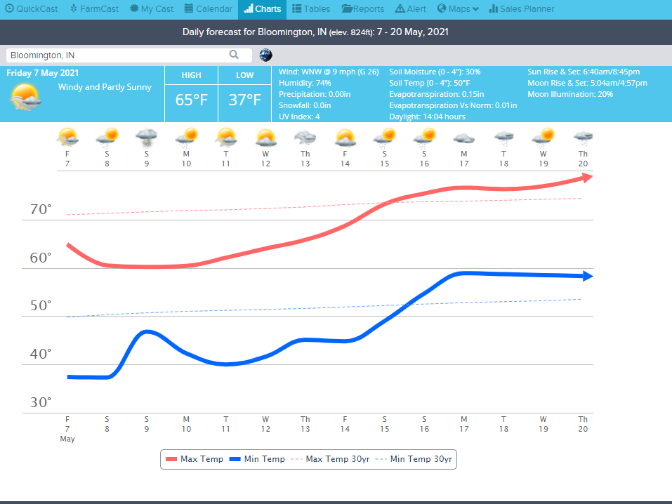

Tomorrow night the low temperature will be 37 degrees. 36 degrees means that patchy frost can happen. 34 degrees means frost is likely. Here's what the National Weather Service says:
.Short Term...(This evening through Friday night)
Issued at 248 PM EDT Thu May 6 2021

For latest thoughts on the ongoing showers and storms, see the
latest mesoscale update above.

Going into the late evening and overnight hours, showers will
gradually come to an end as the front exits the area by midnight.
The moist air aloft associated with the frontal system will also
quickly exit the area allowing for clearing across the southern
portions of the forecast area with some clouds persisting across the
north where some mid level moisture transport should allow for
continued cloud cover.  Lows tonight look to drop into the upper 30s
which should be warm enough to prevent any frost except in extremely
favored cool and sheltered locations.

During the daytime hours tomorrow, a series of weak vort maxes will
continue to circulate around the more broad trough which should lead
to some isolated rain showers.  Dry adiabatic lapse rates are
expected up to around 775mb which should also allow for the mixing
down of winds associated with a weak LLJ.  Not expecting anything
much more than 20-25 mph with occasional gusts to 30 mph.  With
these steep lapse rates and the relatively steep lapse rates above a
weak capping inversion, a rumble of thunder or two can`t be ruled
out tomorrow afternoon with graupel possible across the northeastern
counties where the vort max is expected to be strongest along with
the coolest temperatures aloft.

With the dry surface air and clearing skies Friday night,  lows may
fall locally into the mid 30s and possibly even lower in localized
areas.  Frost looks probable across the northeastern counties which
are expected to remain the coldest. Will hold off on any headlines
to avoid confusion that it could possibly be tonight, along with
waiting until confidence on where the more widespread frost can
increase.
.Short Term...(This evening through Thursday night)
Issued at 237 PM EDT Wed May 5 2021

Occasional wind gusts of 15-20 mph are likely to continue through
the rest of the afternoon with nearly dry adiabatic mixing down from
around 850mb. After 00Z, those winds will begin to come down as a
surface inversion begins to build in.  The diurnally driven clouds
at around 4000ft will also dissipate with the loss of the afternoon
heating.  Dry weather will continue through the night into the early
morning hours before precipitation moves in from the west.

A broad closed low will be moving through southern Canada with an
associated surface low and cold front stretching down across the
Upper Midwest.  This front will pass through during the afternoon
hours tomorrow.  Model soundings show a skinny CAPE profile with
steep lapse rates from the surface up to about 600mb.  With the
freezing level only at 5000ft, any stronger shower is likely to
produce a few rumbles of thunder and small hail even with the
shallow cloud tops.  The better CAPE will be across south central
Indiana where surface dewpoints will be a bit higher and allow for a
more shallow LCL and higher LFC.  A few stronger updrafts with large
hail are possible across those areas where the cloud tops should be
tall enough to loft a few larger hailstones. Don`t disagree with the
small marginal risk introduced by SPC for the Day2 outlook, but do
think that the hail risk is the larger threat compared to damaging
winds.

In the aftermath of the frontal passage, winds will become
northwesterly with dry air aloft clearing the residual clouds.  Lows
may fall locally into the mid 30s with the efficient radiational
cooling provided as winds begin to calm and skies clear.  Some
patchy frost looks possible in favored areas, but coverage looks
limited enough that impacts don`t look to warrant a Frost Advisory
at this time.

&&

.Long Term...(Friday through Wednesday)
Issued at 237 PM EDT Wed May 5 2021

...LOCALLY HEAVY RAIN POSSIBLE SATURDAY NIGHT INTO SUNDAY...

A quick moving cold front will move through the area on Friday.
Forcing and moisture look limited with it. Will have some low PoPs
most areas Friday afternoon with it. Cold air behind the front,
combined with lighter winds and clear to partly cloudy skies, could
lead to some patchy frost northeast Friday night.

Some weak isentropic lift ahead of a developing low pressure system
could bring a few showers mainly late on Saturday.

Low pressure will ride along a front south of the area Saturday
night into Sunday. A baroclinic zone will set up aloft over the
area. An 850mb jet will bring moisture into the area as well. With
this forcing and moisture, will go with likely category or higher
PoPs most areas Saturday night into Sunday.

Integrated water vapor transport forecasts show the best import of
moisture to the southern forecast area. Precipitable water values
will be over an inch south, with some models forecasting near record
values. Thus feel the main threat for heavy rain will be south of
Interstate 70, and more likely across the southern third of the
forecast area.

The system exit the area by Monday with high pressure building in.
Will go dry Monday and Tuesday for most areas.

Confidence lowers for Wednesday`s forecast as guidance differs on
the evolution of a couple of systems that could impact the area.
Will just go with low PoPs for now to account for the uncertainty.

Continued shots of cooler air from the north will keep temperatures
below normal through the period. Highs on Sunday could be 15 degrees
or more below normal.