
Area Forecast Discussion
National Weather Service Indianapolis IN
616 AM EDT Mon Oct 30 2023

...Updated Aviation Discussion...

.Key Messages...

 * Rain ending early this morning and clouds decreasing today

 * Renewed surge of cold air bringing a hard freeze tonight

 * Snow showers and bursts of reduced visibility possible Tuesday

 * Strong wind gusts and low wind chills Halloween evening

.Short Term...(Today and tonight)
Issued at 245 AM EDT Mon Oct 30 2023

Radar mosaic shows moderate rain has shifted south of central
Indiana has of this writing, with light rain continuing across
portions of central Indiana. Precipitation is oriented along and
parallel to the front and is largely anafrontal. Model cross section
shows slopping frontal surface and observations. All this ties back
to a low-amplitude shortwave trough moving across the region. As it
progresses eastward, ascent/moisture will as well, and rain may
linger in the southeast early morning but diminish later. Cold
advection should be strong enough to hold temperatures in the mid
40s.

A deep strongly subsident regime is indicated in model soundings
later today, and the northwestern most cloud edge should move south
of the area by later in the day. Position of the surface high won`t
be optimal for radiative conditions, but preconditioning through
cold advection and at least modest radiational cooling should
support a widespread hard freeze across all of central Indiana. We
have upgraded the Freeze Watch for tonight and early Tuesday morning
to a Freeze Warning.

&&

.Long Term...(Tuesday through Sunday)
Issued at 245 AM EDT Mon Oct 30 2023

The primary forecast challenge during the long term period is the
potential for snow showers Tuesday afternoon and evening. Aloft, a
potent mid-level vort max is modeled to drop southward out of Canada
today. This feature subsequently triggers surface cyclogenesis
allowing a weak closed low to develop by early Tuesday. This low
should then swing southward over Lake Michigan and into northern
Indiana. A few possibilities exist regarding this system and
potential impacts to our weather.

Beginning with the most likely effects regardless of precipitation
potential, is gusty winds associated with the system`s strengthening
surface cold front. Winds may gust to 25 or even 35 knots at times
once the front passes through. Additionally, these winds will be
advecting in much colder air...and temps may be into the mid 40s
just prior to frontal passage, before quickly dropping into the 30s.
As such, wind chills could be quite low during peak trick or
treating hours (low 20s, possibly upper 10s).

Next, a few possibilities exist regarding precipitation potential.
No precip at all is also a possibility as moisture is limited.
However, given the magnitude of frontogenesis in the models, and the
increasingly steep lapse rates along the boundary...enough
confidence exists to include light precipitation in the forecast.
Model soundings show a small positive area located in the dendritic
growth zone, along with a dry surface layer so that wet-bulb temps
are below freezing. Precipitation type would be primarily frozen
(snow or graupel), although some rain could be mixed in at onset.
The best chance of snow showers / flurries would be from
Indianapolis northward...simply because these locations are closer
to the surface low with better upper-level support as well.

A much lower likelihood scenario is the possibility of heavier
bursts of snow/graupel more reminiscent of snow squalls. Enough low-
level instability and forcing exist for model snow squall parameters
greater than 3. The limiting factor here is moisture availability.
The HRRR, for instance, is far more moist than other hi-res guidance
and subsequently shows a narrow more intense band of precip right
along the advancing boundary. Hi-res guidance also shows the surface
low becoming temporarily invigorated as it passes over the still-
warm Lake Michigan. These solutions are outliers, so am leaning
against as of now. But it bears watching...

To summarize: the most likely scenario is for isolated light snow
showers Tuesday afternoon with colder temps and increasingly gusty
winds in the post-front environment. Best chance of precip is north
of Indianapolis.

The rest of the long range looks quite benign...with surface high
pressure sliding south and east allowing low-level flow to gain a
southerly component. As such, a warming trend is likely by Thursday
with highs climbing back into the 50s, potentially pushing 60 over
the weekend with above-freezing lows. Potential for rain showers
over the weekend is increasing, but still low, as guidance remains
in poor agreement regarding strength, timing, location of a system
passing nearby.

Start cleaning the dust out of the furnace and the heaters. Most people hate the smell of the heat being turned on for the first time but I like it. Get ready because next week will be cold! I expect us to have our first hard freeze by Monday night. All Hallows Eve is going to be very cold with a high of 45 and a low of 25. The Euro model gives us some snow flurries on Tuesday night into Wednesday morning but it is the only model showing that right.

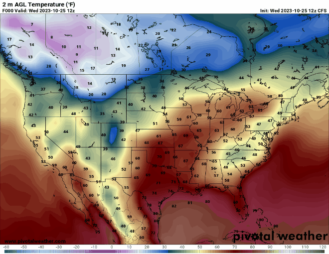
The CFS model is saying the rest of November will be mild or at least until Thanksgiving.


#BOTS fans, check this out!
October 7.


Expect sunny skies for most of next week. We might get into the mid 80's by Wednesday and then SIGNIFICANTLY cooler weather by next weekend. Are you ready for low temperatures in the mid 40's?
In my opinion fall seems to start in late August nowadays, probably due to climate change but here's an example of what I'm seeing:


