Brood X Cicadas will be coming in May. Get ready!

The soil temperature needs to be 64 degrees before the cicadas emerge from the ground. They typically live 16-18 inches below the surface. Here are some soil temperature sites which are also good for the planting season.

https://www.weather.gov/ncrfc/LMI_SoilTemperatureDepthMaps

http://news.ncgapremium.com/index.cfm?show=1&mapID=20

https://www.greencastonline.com/tools/soil-temperature

If you've never experienced the cicadas and their mating noise, it is very loud and sounds like a UFO has landed. If you've never experienced a UFO landing then imagine what it sounds like in science-fiction movies.

Their average lifespan is about six weeks long so don't expect them to start dying off until first week of July.


A freeze watch has been issued.

 URGENT - WEATHER MESSAGE

National Weather Service Indianapolis IN
959 AM EDT Mon Apr 19 2021

INZ021-028>031-035>049-051>057-060>065-067>072-192200-
/O.CON.KIND.FZ.A.0003.210421T0200Z-210421T1400Z/
Carroll-Warren-Tippecanoe-Clinton-Howard-Fountain-Montgomery-
Boone-Tipton-Hamilton-Madison-Delaware-Randolph-Vermillion-Parke-
Putnam-Hendricks-Marion-Hancock-Henry-Vigo-Clay-Owen-Morgan-
Johnson-Shelby-Rush-Sullivan-Greene-Monroe-Brown-Bartholomew-
Decatur-Knox-Daviess-Martin-Lawrence-Jackson-Jennings-
Including the cities of Delphi, Flora, Williamsport,
West Lebanon, Lafayette, West Lafayette, Frankfort, Kokomo,
Attica, Covington, Veedersburg, Crawfordsville, Lebanon,
Zionsville, Tipton, Fishers, Carmel, Noblesville, Anderson,
Muncie, Winchester, Clinton, Newport, Rockville, Greencastle,
Plainfield, Brownsburg, Danville, Indianapolis, Greenfield,
New Castle, Terre Haute, Brazil, Clay City, Spencer,
Martinsville, Mooresville, Greenwood, Franklin, Shelbyville,
Rushville, Sullivan, Linton, Bloomfield, Bloomington, Nashville,
Columbus, Greensburg, Vincennes, Washington, Loogootee, Shoals,
Bedford, Mitchell, Seymour, Brownstown, and North Vernon
959 AM EDT Mon Apr 19 2021

...FREEZE WATCH REMAINS IN EFFECT FROM TUESDAY EVENING THROUGH
WEDNESDAY MORNING...

* WHAT...Sub-freezing temperatures as low as 28 possible.

* WHERE...Central Indiana.

* WHEN...From Tuesday evening through Wednesday morning.

* IMPACTS...Frost and freeze conditions could kill crops, other
  sensitive vegetation and possibly damage unprotected outdoor
  plumbing.

* ADDITIONAL DETAILS...Another night of sub-freezing
  temperatures is likely Wednesday night.

PRECAUTIONARY/PREPAREDNESS ACTIONS...

Take steps now to protect tender plants from the cold. To prevent
freezing and possible bursting of outdoor water pipes they should
be wrapped, drained, or allowed to drip slowly. Those that have
in-ground sprinkler systems should drain them and cover above-
ground pipes to protect them from freezing.

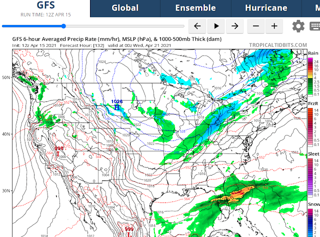
#BOTS! Winter returns next week!

 So far the GFS and the Canadian model are picking up on snow showers for next week.


Here are the details from the National Weather Service:

.Long Term...(Saturday Night through Thursday)
Issued at 242 AM EDT Fri Apr 16 2021

A series of weak upper level systems will bring periodic chances for
light rain through the period and keep temperatures near to slightly
below normal.  During the daytime hours on Sunday, the first system
of the period will be moving in from the northwest.  Models have a
pretty good handle on the synoptics of the system with a weak
shortwave trough passing through the area.  With southerly flow cut
off by a more substantial system to the south, don`t expect much
more than very light rain during the daytime hours.  A brief break
in the precipitation is anticipated for Monday before a more
substantial system arrives on Tuesday.

On Tuesday, a much stronger upper level low pressure system will be
moving through southern Canada with a surface front stretching to
the south.  Upper level dynamics are much stronger with this system
and with good forcing associated with the front, expect a fairly
widespread area of light to moderate rain.  Cold air will be
arriving as the system exits Tuesday night with the potential for a
few snow showers before sunrise. Another vort max associated with a
secondary low pressure system looks to pass through the area
Wednesday into Wednesday night which could squeeze out some
additional light rain.

After the passage of the front on Tuesday, lows look to drop into
the low 30s across much of central Indiana Tuesday and Wednesday
nights which may require headlines by early next week.  At a
minimum, conditions currently look favorable for widespread frost
each night with light winds and mostly clear skies.

#BOTS!

We have some very light snow flurries here in Bloomington, Indiana. No, this is not an April Fool's joke.

#BOTS!