URGENT - WINTER WEATHER MESSAGE
National Weather Service Great Falls MT
215 PM MDT Mon Aug 27 2018

MTZ012-050-054-280600-
/O.CON.KTFX.WW.Y.0105.000000T0000Z-180828T0600Z/
Cascade-Judith Basin-Meagher-
Including the following locations: Kings Hill Pass
215 PM MDT Mon Aug 27 2018

...WINTER WEATHER ADVISORY REMAINS IN EFFECT UNTIL MIDNIGHT MDT
TONIGHT ABOVE 6500 FEET...

* WHAT...Wet snow. Additional wet snow accumulations of 1 to 3
  inches, with localized totals up to 8 inches over and near Big
  Baldy Mountain, are possible.

* WHERE...The Little Belt Mountains above 6500 feet for portions
  of Cascade, Judith Basin and Meagher counties.

* WHEN...Until midnight MDT tonight.

* ADDITIONAL DETAILS...Unseasonably cold and raw conditions may
  make touring and backcountry recreation difficult.

PRECAUTIONARY/PREPAREDNESS ACTIONS...

A Winter Weather Advisory for snow means periods of snow will
cause primarily travel difficulties. Expect snow covered roads
and limited visibilities, and use caution while driving. The
latest road conditions for the state you are calling from can be
obtained by calling 5 1 1.
Snow is falling in Montana
Lucky's Market
I was going to ride my bike there for there for the awesome special of two slices of pizza and one beer for $5 but the heat index is 101. Nope. I'll pass.
NWS: Hot and Humid!
Special Weather Statement...UPDATED
National Weather Service Indianapolis IN
1259 PM EDT Sun Aug 26 2018

INZ021-028>031-035>049-051>057-060>065-067>072-270100-
Carroll-Warren-Tippecanoe-Clinton-Howard-Fountain-Montgomery-
Boone-Tipton-Hamilton-Madison-Delaware-Randolph-Vermillion-Parke-
Putnam-Hendricks-Marion-Hancock-Henry-Vigo-Clay-Owen-Morgan-
Johnson-Shelby-Rush-Sullivan-Greene-Monroe-Brown-Bartholomew-
Decatur-Knox-Daviess-Martin-Lawrence-Jackson-Jennings-
Including the cities of Lafayette, Frankfort, Kokomo,
Crawfordsville, Anderson, Muncie, Indianapolis, Terre Haute,
Shelbyville, Bloomington, Columbus, Vincennes, Bedford,
and Seymour
1259 PM EDT Sun Aug 26 2018

...Hot and Humid Conditions across Central Indiana This Afternoon
and Monday afternoon...

High temperatures this afternoon and Monday afternoon will range
from the upper 80s to the lower 90s across central Indiana. In
addition, dewpoint temperatures will be in the 70s. This will
lead to peak afternoon heat index values as high as 100 degrees or
slightly higher at some locals.

Heat index values this high increase the risk of developing heat
illnesses. Dress lightly, drink plenty of fluids, and limit time
outdoors today, and check on the elderly and infirm, as well as
those without access to air conditioning.

Heat illness develops quickly and can overtake you with little
forewarning.
The heat is making it's last stand.
The weather in Bloomington with be hot and humid until September 6th to the 8th. After that, summer will be on its way out.
Flip flop again!
The computer models are having a hard time figuring out what to do about the last week of August into the first week of September. Now they indicate a return to hot and humid weather. The target dates are from Sunday August 26 to Monday September 3. It looks like a week to eight days of near 90 degree heat before it cools off again. After that we begin our slow decline into fall-like temperatures.


Storm is just south of Bloomington.
There's a storm to our south tracking north eastwards. There's also a second larger line of storms on the Illinois / Indiana boarder moving eastwards though it appears to be weakening.


New models suggest cooling trend.
Temperatures will cool off a bit towards the end of August.
.LONG TERM (Thursday Night Through Monday)...
Issued at 252 PM EDT Mon Aug 13 2018

Models are close enough that the model blend initialization
was accepted for most items.

One upper trough will linger across the area during the early part
of the long term, and then another will approach late in the period.
At the surface, a front will meander across the area.

The result will be chances for rain for most areas through the
period. Models continue to differ on the details for the weekend, so
confidence is low for then.

Temperatures will remain near normal.

Uh oh, Say it ain't so!
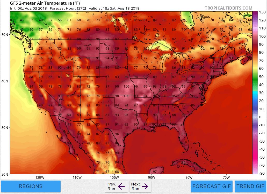
It looks like the heat is going to make a comeback during the middle part of August. It looks like the heat will park right over the midwest. Specifically it will arrive on August 12 and last through August 20. Check out this 98 degree forecast for August 18.

Subscribe to:
Comments (Atom)