#BOTS Party!
The party just ended. Thanks to everyone who came over. No one wanted their picture taken for the blog but that's okay. This is the official end of #BOTS for the year. I hope you all had a great time and enjoyed yourselves. Drive safely.


#BOTS fan party tomorrow!
#BOTS fans, this is it! Last snow of the season. I'm having a party to celebrate. Check this out:


Rain and more rain.
It's going to rain today through Saturday. Highs will be in the 50's to 60's throughout the period. Nothing else is going on.
Unfortunately, I think it's time to retire the #BOTS tag until November. April looks to be slightly warmer than normal with daytime high temperatures slowly increasing on April 2 through April 10th from 59 to 76 degrees.
Bring on the Summer Season.
Unfortunately, I think it's time to retire the #BOTS tag until November. April looks to be slightly warmer than normal with daytime high temperatures slowly increasing on April 2 through April 10th from 59 to 76 degrees.
Bring on the Summer Season.
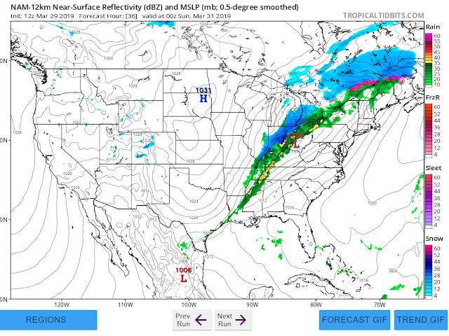
For #BOTS fans only.
This is the only thing showing in the long range as far as snow is concerned. It's just might be over. This is our last chance for ro-mance.


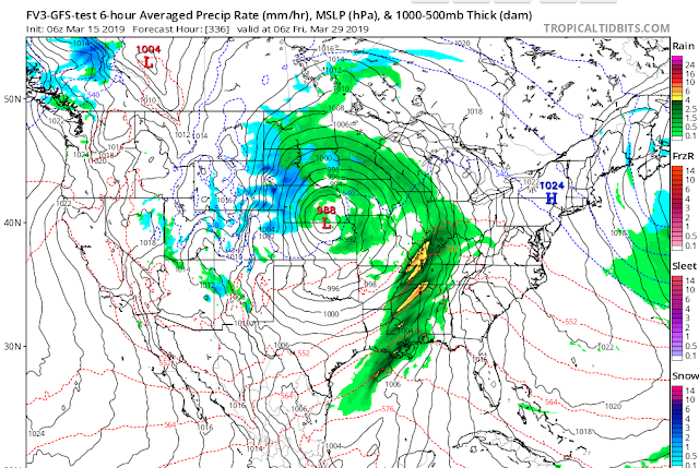
It's all about the pattern.
The pattern we are in is showing support for two more storms just like the one we had yesterday. Here is the GFS model's view for Friday March 29:

Almost over!
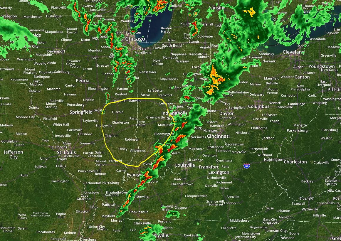
The Tornado Warning for Monroe County has ended and the main line of storms is off to our east but there is still a chance for redevelopment in the area below:
Also remember that the Tornado watch does not expire until 5:00pm
Also remember that the Tornado watch does not expire until 5:00pm
The good news.
The only good news that I have is that the dewpoint remains at 57. Dewpoints above 60 have support for tornadoes. Check out this map:


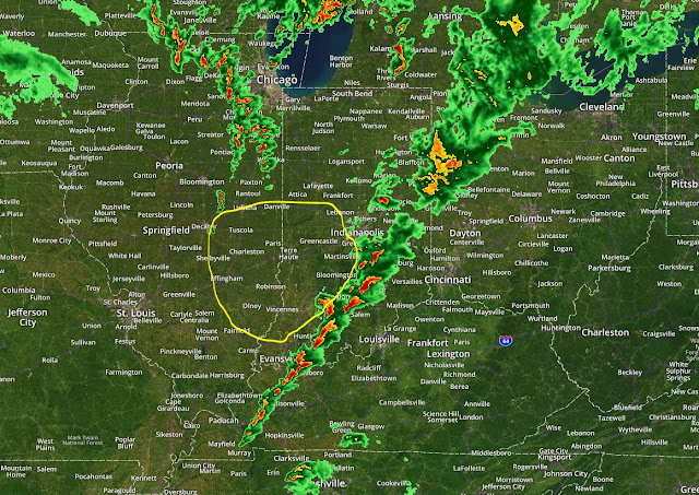
Beware of the training effect.
In normal cases when a tornado has passed through your area it's fine to leave your "safe spot" or shelter. In this case storms are re-appearing over the same area over and over again. It might be best to stay in your safe space until radar indicates that the line of storms has shifted to the east. Right now the training effect is in this area:


Highest risk of tornadoes for Indiana today.
Here's the map I've drawn. Expected time is between 11am and 5pm with 2:00pm looking particularly dangerous as dewpoints reach 60.


Tornadoes are possible tomorrow.
Pay close attention to the weather tomorrow. No one can predict when and where a tornado will happen twenty-four hours in advance but the ingredients for one are certainly there for Thursday.
The STP (Significant Tornado Parameter) has a bullseye right over Bloomington. STP = 1.6 for Monroe County tomorrow.


Here's a look at the Supercell Composite

Here is the (very long) discussion from the NWS;
The STP (Significant Tornado Parameter) has a bullseye right over Bloomington. STP = 1.6 for Monroe County tomorrow.


Here's a look at the Supercell Composite

Here is the (very long) discussion from the NWS;
NEAR TERM /Rest of Today/...
Issued at 956 AM EDT Wed Mar 13 2019

Isolated to scattered light showers north of I-70 will continue to
move east across the area and then out of the area by late this
morning setting up for a dry afternoon. Still looking at mostly
cloudy skies but with southerly flow highs should still climb into
the 60s. Made some minor adjustments to the PoPs for the next few
hours based on radar reflectivity trends but otherwise no
appreciable changes made. Previous discussion follows...

Table setting day for central Indiana and the Ohio Valley as the
intense surface low currently organizing over Colorado strengthens
and kicks out into the High Plains later today. Convection
associated with storm system currently extended from western Kansas
south into west Texas and will progress E/NE throughout the day
steadily before moving into the region in a weakened state this
evening into the overnight.

Initially though...the focus will be on the area of showers over the
mid Mississippi Valley. Residual dry air and subsidence through the
boundary layer was creating a more hostile environment for rain to
overspread the forecast area currently but the arrival of better
lift and forcing aloft into the region over the next few hours will
enable a steady top down saturation of the column through daybreak.
Hi-res guidance brings the focus of most of the rain through the
morning to areas mainly near and north of I-70 with the associated
area of lift shifting northeast by early afternoon. The afternoon
will see the initial transition for the region into the warm sector
with model soundings and RH progs suggesting some sunshine and
breezy southerly flow.

Temps...spring-like feel expected for today...especially this
afternoon as temperatures rise into the 60s with clouds scattering
and southerly winds advecting warmer air into the Ohio Valley.
Generally took a split of the model guidance with a closer lean to
the cooler MAV as the MET guidance looks a bit aggressive with
warming later today.

&&

.SHORT TERM /Tonight through Friday Night/...
Issued at 354 AM EDT Wed Mar 13 2019

Forecast challenges focus on impacts from gradient winds and severe
storms Thursday as the weakening surface low tracks into the western
Great Lakes by Thursday evening. While some murkiness lingers within
the details which lowers confidence a bit...remain concerned about a
period of high impact weather for central Indiana on Thursday.

The initial axis of prefrontal convection that will expand east from
the High Plains this morning should be located in the vicinity of the
Mississippi River by early evening. While the focus for stronger
convection will remain southwest of the forecast area from mid
evening into the early overnight...expect scattered showers will
overspread the region with some embedded thunderstorms as model
soundings show elevated instability present above an expanding
shallow inversion. Surface flow will be gusty with a strong 850mb
jet nearing 70kts moving through the area late tonight...but the
presence of the strengthening inversion should keep most of the
stronger winds aloft from reaching the near surface layer through
daybreak Thursday.

The bulk of the hi-res guidance shifts most of the prefrontal
convection set to impact the region tonight east of the area
Thursday morning which when coupled with the dynamics present over
the area later in the day...raises the ceiling for potential severe
weather ahead of the occluded boundary during the afternoon. The
initial low level jet will shift east of the area Thursday morning
but a second jet will swing around the base of the upper low over
the Plains and nose back into the region by the afternoon. Further
up in the atmosphere...mid and upper level diffluence will increase
with the presence of stronger jets in both layers over the Ohio
Valley. 100+kts noted at 500mb Thursday afternoon is particular
impressive. BL shear will steadily increase across the area into the
afternoon and while strongest helicities in the 0-1km and 0-3km
layer will be focused east of central Indiana...values remain more
than sufficient to support severe convective development.

With all of the factors present above...confidence is higher in a 2-
4 hour window during the afternoon where storms can develop and may
quickly become severe as they rapidly move east. The key to whether
the severe threat is isolated or more substantial will come down to
available instability and moisture return in the dry slot between
the prefrontal convection and the occluded front. Hi-res guidance
has shifted more ominously in the direction of a potential greater
threat with MLCAPE levels rising to near 1000 j/kg with dewpoints
climbing into the mid and upper 50s within a narrow axis over the
forecast area by 18-19Z. And while lapse rates aloft are a bit lower
than would be desired to support a greater severe threat...there
does appear to be enough of a steepening within the 700-500mb layer
overlaid on the instability axis over the region.

Should this come to fruition...the hi-res solution suggestive of a
broken but potentially potent line of convection developing in the
Wabash Valley around midday and moving east through the afternoon is
becoming a real possibility. All severe threats would be on the
table...damaging winds most prevalent considering the screaming
winds aloft which any stronger cell would be able to tap into.
However...the presence of long curving hodographs courtesy of the
stronger low level helicity levels supports a tornado threat and wet
bulb zero values at 6-7kft also present a hail risk.  As mentioned
above...there is still some detail that model runs later today and
tonight will hopefully clear up...but the threat for severe storms
is higher than it looked to be Tuesday. Stay tuned.

Not to be lost in the growing severe threat is the continued concern
for strong gradient winds outside of any convection due to the
intense flow aloft. Remain reasonably concerned that there could
still be periods Thursday where stronger boundary layer mixing can
occur and support peak gusts rising into advisory criteria at a
minimum. Again...the convective development could scuttle a more
widespread and prolonged high wind threat and with some clarity
still needed...will not introduce any headlines as of yet. Will
however highlight the high wind and severe potential via an SPS.

Brief postfrontal clearing Thursday evening will occur before clouds
expand back into the region as the cold pool overspreads the lower
Great Lakes. A trailing upper level wave and surface trough on the
back side of the departing system Friday morning may bring a few
light rain showers to primarily the northeast half of the forecast
area on a brisk and noticeably colder day. Rain will end by Friday
evening with skies slowly clearing from the west overnight as high
pressure builds in.

Temps...the possibility of some sunshine developing ahead of any
convection Thursday raises the potential for temperatures to warm
into the lower to possibly mid 70s over parts of the forecast area.
Low level thermals support a model blend for highs. Will lean a bit
closer to the cooler MET guidance for Friday highs which may end up
being close to 30 degrees colder than Thursday highs. An overall
model blend will work fine for lows through the period.

&&

.LONG TERM /Saturday night through Wednesday/...

Issued at 253 PM EDT Wed Mar 13 2019

Generally quiet weather is in store for central Indiana through
the long term. Below normal temperatures are expected with an
upper trough in place over nearly the eastern half of the U.S.
Small chances for rain or even a brief rain/snow mix will slide
through central Indiana through the period as weak upper waves
make their way through the upper trough. High confidence in below
normal temperatures, with low confidence in precipitation chances.


Something to mention.
I've heard several people say that this is our last snow. I would caution against saying that. March is a very tricky Month. You can have above average weather with tornadoes or below average weather with snow and sometimes a combination of both which is what I'm inclined to believe. To illustrate a point, here is one model's idea of what will happen on March 20 - 21; the first day of spring. Notice where the blue freezing line is. It's in Florida! That is a lot of cold air, possibly even arctic air for us if the freezing line that far south.


How did we get so luck? (or unlucky depending on your point of view)
From Channel 13 News:

3-4+ right over Bloomington.
#BOTS!

3-4+ right over Bloomington.
#BOTS!
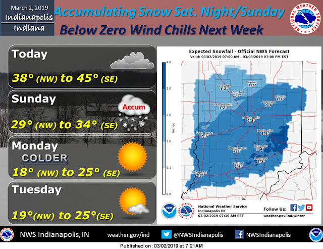
Snow chances today.
I'm expecting us to get 2 inches of snow tonight with the possibility of seeing 3 in isolated areas. Dry air is already eating away at some of the snow. That is why you can't see snow out of your window and yet it appears on radar.


Light snow expected on Thursday before a warm up.
March is looking to be cooler than normal but nowhere near as cold as the last two days have been. Snow moves in Thursday and overnight into Friday. Expect 1-2 inches.


24 -72 Hours can make all the difference.
This is why I say never trust a forecast beyond three days.
March 1, 2019: 4-6 inches of snow forecasted for March 3rd.


March 2, 2019: 2-3 inches of snow forecasted for March 3rd.
March 2, 2019: 1-2 inches of snow forecasted for March 3rd.

Hmmmm... let me guess...
March 3rd = 0 inches of snow and 60 degrees and tornadoes!

March 1, 2019: 3 inches of snow forecasted for March 3rd.

March 2, 2019: 2-3 inches of snow forecasted for March 3rd.

March 2, 2019: 1-2 inches of snow forecasted for March 3rd.

Hmmmm... let me guess...
March 3rd = 0 inches of snow and 60 degrees and tornadoes!


From boom to bust!
Latest morning data says 1.4 inches of snow for Bloomington for Saturday and Sunday.


Subscribe to:
Posts (Atom)