It's that time of year again when pictures of winter storms that are two weeks away appear show snow accumulations of 30+ inches. Do not fall for these as they are being circulated on social media. These are operational computer models that spit out one like that and then in the next 6 to 12 hours the same model will say sunny and warm with a chance of thunderstorms. Please take these pictures with a grain of salt. 24 to 48 hours before the event is to arrive is when you have the best forecast information.
There does appear to be something showing up in the models for the central Indiana area for December 8th - 10th but that's about all anyone can say. Actually, ensembles seem to be trending slightly warmer with a more zonal flow towards the middle of December.
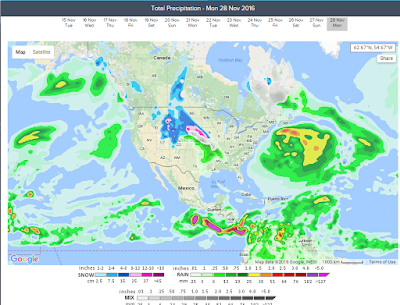
Showers and storms possible on Monday 11/28.
Monday should be a rainy and windy day. The area inside the red circle should watch out for wind damage.


A high of 74 today and 71 tomorrow.
Enjoy it while it lasts folks. This coming weekend is going to feel much colder with temperatures dipping into the mid 20 for Saturday night.
Below I've attached my "very general", "non-specific" winter analysis. It looks like we are going to have a weak La Nina in play. I think we will see shots of warm air followed by cold air followed by warm air and then cold air again (see Rossby Waves below). The light blue represents where the persistent cold will be. The orange represent the pacific jet stream transporting the warm air and the red represents the likely storm track. If the pacific jet and the storm track and the cold front happen to line up just right say over Kentucky, then we get snow. If not we get a lot of rain.
 If you are a #BOTS! fan then this is probably not such great news. Snow lovers would like a scenario more like this:

Below I've attached my "very general", "non-specific" winter analysis. It looks like we are going to have a weak La Nina in play. I think we will see shots of warm air followed by cold air followed by warm air and then cold air again (see Rossby Waves below). The light blue represents where the persistent cold will be. The orange represent the pacific jet stream transporting the warm air and the red represents the likely storm track. If the pacific jet and the storm track and the cold front happen to line up just right say over Kentucky, then we get snow. If not we get a lot of rain.


NWS says no snow for the Bloomington IN area this weekend.
Snow chances increase from 20% upwards from a line north and east of Crawfordsville, to Indianapolis to Greensburg.


Sunday, November 27 low temperature of 25 degrees in Bloomington, Indiana
Get ready for the hard freeze! Overall though, the trend has been slightly warmer than average.

The trend line below definitely captures what it has felt like so far.

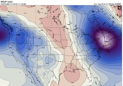
An interesting setup for Monday, November 28th.

The trend line below definitely captures what it has felt like so far.

An interesting setup for Monday, November 28th.

A special weather statement has been issued for North Dakota
SPECIAL WEATHER STATEMENT
NATIONAL WEATHER SERVICE BISMARCK ND
239 PM CST MON NOV 14 2016

NDZ001>005-009>013-017>023-025-031>037-040>048-050-051-150445-
DIVIDE-BURKE-RENVILLE-BOTTINEAU-ROLETTE-WILLIAMS-MOUNTRAIL-WARD-
MCHENRY-PIERCE-MCKENZIE-DUNN-MERCER-OLIVER-MCLEAN-SHERIDAN-WELLS-
FOSTER-GOLDEN VALLEY-BILLINGS-STARK-MORTON-BURLEIGH-KIDDER-
STUTSMAN-SLOPE-HETTINGER-GRANT-BOWMAN-ADAMS-SIOUX-EMMONS-LOGAN-
LA MOURE-MCINTOSH-DICKEY-
INCLUDING THE CITIES OF...CROSBY...BOWBELLS...POWERS LAKE...
LIGNITE...COLUMBUS...PORTAL...MOHALL...GLENBURN...SHERWOOD...
BOTTINEAU...ROLLA...DUNSEITH...ROLETTE...SHELL VALLEY...
ST. JOHN...WILLISTON...NEW TOWN...STANLEY...PARSHALL...MINOT...
VELVA...TOWNER...DRAKE...RUGBY...WATFORD CITY...KILLDEER...
HALLIDAY...BEULAH...HAZEN...CENTER...GARRISON...WASHBURN...
UNDERWOOD...WILTON...TURTLE LAKE...MCCLUSKY...GOODRICH...HARVEY...
FESSENDEN...CARRINGTON...BEACH...MEDORA...DICKINSON...MANDAN...
BISMARCK...STEELE...TAPPEN...JAMESTOWN...MARMARTH...MOTT...
NEW ENGLAND...ELGIN...CARSON...NEW LEIPZIG...BOWMAN...HETTINGER...
FORT YATES...SELFRIDGE...SOLEN...LINTON...STRASBURG...NAPOLEON...
GACKLE...LAMOURE...EDGELEY...KULM...WISHEK...ASHLEY...OAKES...
ELLENDALE
239 PM CST MON NOV 14 2016 /139 PM MST MON NOV 14 2016/

...WIND...COLD AND HEAVY SNOW ARE POSSIBLE LATE THIS WEEK...

MUCH COLDER TEMPERATURES AND WIND CHILLS IN THE TEENS AND SINGLE
DIGITS ARE POSSIBLE LATE THIS WEEK AND INTO THE WEEKEND. HEAVY
SNOW AND GUSTY NORTH WINDS ARE POSSIBLE THURSDAY EVENING THROUGH
FRIDAY. CONSIDERABLE UNCERTAINTY REMAINS IN THE EXACT
TRACK...SPEED...AND STRENGTH OF THE STORM SYSTEM.
HOWEVER...IMPACTS TO TRAVEL AND COMMERCE ARE POSSIBLE OVER PARTS
OF THE REGION. TAKE TIME NOW TO PREPARE FOR THE POSSIBILITY OF
SIGNIFICANT WINTER WEATHER. BE SURE TO MONITOR THE LATEST FORECAST
FOR UPDATES.

What's happening next week?

After that, a strong storm develops over North Dakota and heads north eastwards into Canada.

Once the storm exits, it drags some colder air in behind it.


Strong pacific air to keep things a little warm for a while.
It looks like the cold air has moved into Russia while the warm air from the pacific and southeast Asia are being funneled into North America. There will still be intervals of cold shots but the pattern is looking warmer than normal for now.


Winter is just around the corner!
I apologize for being away so long. Nonetheless I'm back and winter will be back soon too. Currently in Bloomington, Indiana it is 60 degrees. It has been unusually warmer than normal for this area but that is about to change. On Saturday November 12 the low temperature is forecast to be near freezing. The National Weather Service says 33 degrees. Weather Underground says 32 degrees and AccuWeather says 29 degrees. Either way, this will mean an end to the growing season.
Beyond that, all eyes turn to November 18 - 20 and the week of Thanksgiving. Storms systems have been popping up and disappearing on the models for both weeks. I think the Thanksgiving storm is the one worth keeping an eye on but remember, these are weeks away and a lot can change by then.
As of now my first impressions are that November and December are slightly above normal in temperatures while January will be below normal. We'll see how it all plays out.


A 965 Low right on the edge of the coast line?
Subscribe to:
Posts (Atom)