The southeast ridge that was responsible for our heat last week is showing signs of disappearing by October 4th or 5th. That's about nine days away and still too early to tell with any degree of certainty but if it does happen, expect even colder air to filter in.
Sunset over Bloomington Indiana - Sunday, September 23rd.
I caught this while coming out of Lucky's Market on the south side.


Rain for the rest of today.
The sun will come out tomorrow. I would like to break into an "Annie" theme song but I'll refrain from doing so. The rest of the week looks incredibly beautiful.

If it were not for that southeastern ridge trying to pump in heat into our area, we would be seeing even cooler temperatures. We seem to be right in the battle zone between the cold air and warm air.

Severe weather potential for Monday into Tuesday

.SHORT TERM...(Tonight through Tuesday night)
Issued at 311 AM EDT Sun Sep 23 2018

Models are close enough that the model blend initialization
was accepted for most items.

As an upper trough digs into the northwestern USA, southerly flow
aloft will increase across central Indiana. This will bring more
moisture along with forcing from individual impulses moving through
the flow.

By Tuesday night, the upper trough will be approaching the area
along with a surface cold front.

The result of all of this will be likely PoPs at times through the
short term period.

Precipitable water values will increase to potentially 1.5 to 2
inches, which is quite high for this time of year. Thus some locally
heavy rain is possible, mainly across the southern forecast area
where the higher values will be.

Will also have to watch out for the potential for a few strong
storms at times, depending on whether enough instability can build.
The Storm Prediction Center has placed parts of the area in a
Marginal Risk Monday.

The model blend`s temperatures look reasonable given expected
conditions.
Flip flop!
Now the computer models say the heat returns next weekend.

 |
| Heat circulating clockwise around high pressure into mid-west. |

Update for Friday, September 21.
Today is the last day for hot weather. I already miss the the 90's don't you?


A cold front will move through today and there is a chance for severe storms as that happens. The timing is between 3 and 5pm.

After that, fall comes in right on cue. I still think the models are too aggressive with the cold air next weekend. Some are even hinting at snow on October 1st. Don't bet on it though as this is not likely to happen and would be a very rare occurrence. It's not unheard of but it is very rare.


Fall is on the way!
But before we get to that, today will be hot and humid with a high of 92 today and 86 tomorrow.
_____________________
Special Weather Statement


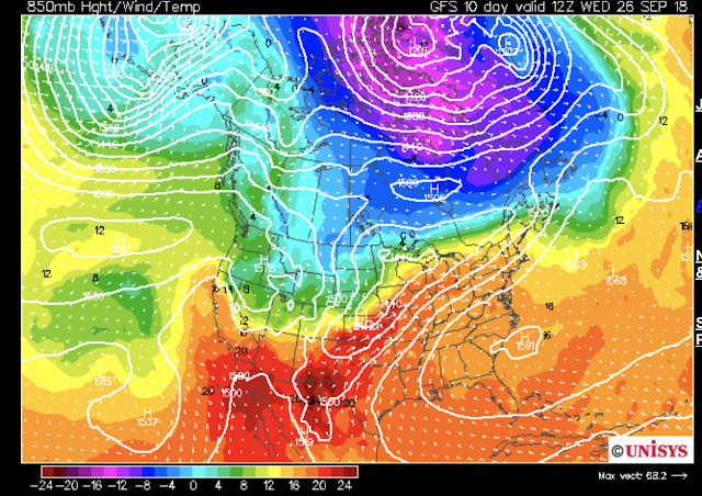
The first model is the GFS and the second one is the Canadian. The blue 540 line depicts the freezing temperature line.
_____________________
Special Weather Statement
Special Weather Statement
National Weather Service Indianapolis IN
423 AM EDT Thu Sep 20 2018

INZ021-028>031-035>049-051>057-060>065-067>072-210000-
Carroll-Warren-Tippecanoe-Clinton-Howard-Fountain-Montgomery-
Boone-Tipton-Hamilton-Madison-Delaware-Randolph-Vermillion-Parke-
Putnam-Hendricks-Marion-Hancock-Henry-Vigo-Clay-Owen-Morgan-
Johnson-Shelby-Rush-Sullivan-Greene-Monroe-Brown-Bartholomew-
Decatur-Knox-Daviess-Martin-Lawrence-Jackson-Jennings-
Including the cities of Lafayette, Frankfort, Kokomo,
Crawfordsville, Anderson, Muncie, Indianapolis, Terre Haute,
Shelbyville, Bloomington, Columbus, Vincennes, Bedford,
and Seymour
423 AM EDT Thu Sep 20 2018

...Hot and Humid Conditions Across Central Indiana This
Afternoon...

High temperatures today will rise into the lower 90s across
central Indiana with dewpoints in the 70s. This will produce peak
afternoon heat index values around 100 degrees in parts of the
area.

Heat index values this high increase the risk of developing heat
illnesses. Dress lightly...drink plenty of fluids and limit time
outdoors today. Check on the elderly and pets, as well as those
without access to air conditioning.

Heat illness develops quickly and can overtake you with little
forewarning.

$$
___________________
After that you'll want to pay attention to September 28-30th. It's very interesting that two computer models are very bullish on cold air coming in next weekend. There may even be some snow in northern Michigan and frost in northern Indiana. I think the models are too bullish with the cold air but when two of them agree, it's worth paying attention to.


The first model is the GFS and the second one is the Canadian. The blue 540 line depicts the freezing temperature line.
Three more days of heat left!
Today, tomorrow and Friday.
Today's high is 91, tomorrow's high is 92 and Friday's high is 88.
After that we cool down but keep in that the air quality outside is terrible right now.
_________________________________
Today's high is 91, tomorrow's high is 92 and Friday's high is 88.
After that we cool down but keep in that the air quality outside is terrible right now.
_________________________________
Air Quality Alert Message
National Weather Service Indianapolis IN
236 PM EDT Tue Sep 18 2018

INZ037-039>041-046-048-054>056-061>064-067-068-071-200000-
Boone-Hamilton-Madison-Delaware-Hendricks-Hancock-Morgan-Johnson-
Shelby-Greene-Monroe-Brown-Bartholomew-Knox-Daviess-Jackson-
Including the cities of Anderson, Muncie, Shelbyville,
Bloomington, Columbus, Vincennes, and Seymour
236 PM EDT Tue Sep 18 2018

...AN OZONE ACTION DAY HAS BEEN DECLARED...

The officials at the  Indiana Department of Environmental
Management have called for an Ozone Action Day on Wednesday...
September 19 for the following Indiana counties...

Boone, Hamilton, Madison, Delaware, Hendricks, Hancock, Morgan,
Johnson, Shelby, Greene, Monroe, Brown, Bartholomew, Knox,
Daviess, and Jackson.

An Ozone Action Day means that a combination of the high
temperatures, light winds, and other factors, are expected to
produce conditions where high levels of ozone emissions may exceed
federally mandated standards.

Here are some recommended actions that the public can take to reduce
ozone forming emissions:

     * Walk, bike, carpool or use public transportation.
     * Avoid using the drive-through and combine errands into one trip.
     * Avoid refueling your vehicle or using gasoline-powered lawn
       equipment until after 7pm.
     * Turn off your engine when idling for more than 30 seconds.
     * Conserve energy by turning off lights or setting the air
       conditioner to 75 degrees or above.
Below normal temperatures are in the long range forecast according to the NWS.
.LONG TERM /Friday through Monday Night/...
Issued at 349 AM EDT Tue Sep 18 2018

A cold front will enter central Indiana on Friday, increasing
shower and thunderstorm chances, the highest being during the
afternoon. As the front sinks farther south though, anticipate dry
air to filter in behind it by Friday night and Saturday. As a
result, will not trend above the low chance pops, yet, that the
latest blended initialization is producing. The front will
eventually stall to the south, keeping low shower and thunderstorm
chances in the forecast through the weekend before shifting back
north as a warm front early next week. Meanwhile, temperatures
through the period will remain well above normal through Friday
before dropping below normal on Saturday through the end of the
forecast period behind aforementioned front.


Monday, September 17th update.
Spotty showers are appearing in the southeastern portion Indiana from the remnants of Hurricane Florence.

High temperatures will be near 90 degrees Tuesday, Wednesday and Thursday. We will most likely hit 90 degrees on Thursday and this will probably be the last 90 degree day until next summer. Rain chances come back into play Friday and Saturday with chances at 50% on both days. Take an umbrella just to be on the safe side.
If there are any other weather geeks and nerds in Bloomington Indiana, Oddball Fermentables has a nice front porch to sit on and watch the storms roll in while sipping a little wine.
Hurricane Florence and the Great Beyond.
There's a 20% chance of rain from the remnants of Hurricane Florence in our area overnight and into Monday.

Here's what the National Weather Service has to say:
.SYNOPSIS...
On the other hand there is a very stubborn and persistent south east ridge (high pressure system) that continues to funnel heat from Texas into the midwest. The problem is that as we approach the fall equinox, the lower sun angle should help reduce the severity of the heat that we receive even as the ridge persists. Take a look at this:
Also take a look at the projected temperatures as measured against the average for the month of September:

As you can see, although the temperatures are above average the overall trend is downward.
The long term looks tricky. The National Weather Service say this:
Here are some computer models for the longe range. This is the GFS outlook for September 29:


This is only just for fun! Please do not take this seriously because it will most certainly not verify but it is fun to look at. Could there be a snow storm by mid October?


Here's what the National Weather Service has to say:
.SYNOPSIS...
Issued at 400 PM EDT Sun Sep 16 2018

The remnants of Hurricane Florence will brush the eastern portion
of the area later tonight into Monday with a chance for showers,
before quickly turning eastward and pulling away from the region.
High pressure will lead to warm and dry weather Monday night into
Thursday. A frontal system late week may bring showers and perhaps
a few thunderstorms to the area for the latter portion of the
forecast period.
The heat and humidity will try and hang on through next week. Expect temperatures in the Bloomington area to be near 90 on Tuesday, Wednesday and Thursday. I know that I've said it before but I think this is summer's last stand. It looks like cooler temperatures are on tap a week from today, Sunday September 23rd.
On the other hand there is a very stubborn and persistent south east ridge (high pressure system) that continues to funnel heat from Texas into the midwest. The problem is that as we approach the fall equinox, the lower sun angle should help reduce the severity of the heat that we receive even as the ridge persists. Take a look at this:

Also take a look at the projected temperatures as measured against the average for the month of September:

As you can see, although the temperatures are above average the overall trend is downward.
The long term looks tricky. The National Weather Service say this:
.LONG TERM (Wednesday Night Through Sunday)...
Issued at 237 PM EDT Sun Sep 16 2018

Models are close enough that the model blend initialization
was accepted for most items.

An upper ridge should keep Wednesday night & Thursday dry, then a
couple of fronts will bring chances for rain into next weekend.
Models are still differing on timing and location of fronts, so
confidence remains low in the PoPs.

Above normal temperatures early in the long term will give way to
seasonable values for next weekend.


Subscribe to:
Posts (Atom)