The hurricanes and tropical storms are taking over winter and keeping us warm. Welcome Tropical Storm Zeta.
A week from this coming weekend we get two more of them at the same time.

The hurricanes and tropical storms are taking over winter and keeping us warm. Welcome Tropical Storm Zeta.
A week from this coming weekend we get two more of them at the same time.
Most people tend to forget about this but we have two severe weather seasons in Indiana. One is in the spring and the other is in the fall. Currently, we are under a marginal risk for sever weather today.


#BOTS fans should pay attention to next week and on Halloween. The National Weather Service in Indianapolis has this to say:
.LONG TERM /Sunday through Wednesday/...
Issued at 345 AM EDT Thu Oct 22 2020

Although, the forecast will start off with unsettled weather Monday
and Monday night as strong southeastward expanding Canadian high
forces yet another cold front southeast across central Indiana. Deep
moisture and moderately strong dynamics, including the area being in
the right rear quadrant of a 140 knot upper jet over southern
Ontario, suggests widespread and then good chance PoPs in the wake
of the cold front Monday and Monday night.

After that, not a lot of forcing as weakening Canadian high pressure
builds in. That said, would not rule out a shower or midweek with
cyclonic flow overhead.

Finally, late in the long term, the eyes will be focusing on a
potent upper vortex, that will be an early cold season wintry
weather maker over the southern Plains. At this point, the GFS is
trending way to fast so, so much so that even the GEFS is
discounted. Prefer the slower ECMWF and ECENS, that typically verify
better with these early cold season harbingers. That said, the blend
was painting small PoPs through most of the rest of the long term
and if there is precipitation around during the pre-dawn, some brief
non-accumulating snow could briefly mix in over northwestern
sections of central Indiana starting Monday night.

In general, thick cloud cover and thermals support 5 to 10 degree
below normal blend temperatures with afternoon highs mostly in the
50s and overnight lows in the 30s.
LONG TERM /Tuesday through Friday Night/...

Issued at 341 AM EDT Sat Oct 17 2020

Synoptic setup early in the extended period consists of a stationary
frontal boundary extending from the Southern Plains northeastward
through the Ohio Valley and into New England.  This will provide
some weak forcing across the southeast two-thirds of central Indiana
early Tuesday for low rain chances.  Moisture will be limited
though, and all of central Indiana is progged to be dry by Tuesday
afternoon.  Nonetheless, there will be a quick uptick in rain
chances from Tuesday night into Wednesday when a surface frontal
system moves through with a 50-60 kt low level jet in its warm
sector. Meanwhile, weak troughing aloft will move through the
Great Lakes Region. After that though, any upper forcing will
be limited until late in the extended period when the next trough
moves through from Thursday night through Friday night. So, any
low precipitation chances from Wednesday night through Thursday
will only be fueled by a lingering surface frontal boundary, and
these chances are low confidence.

Meanwhile, strong warm advection in the aforementioned warm sector
will bump daytime highs into the upper 60s/low 70s on Wednesday
and even low to upper 70s on Thursday. The cooler weather,
however, will return over the weekend after a cold front drifts
through central Indiana.
This is not a forecast. It's just a reminder that we are entering that time of year again when frozen precipitation starts to show up in the Ohio Valley as we approach November. Enjoy the eye candy.


URGENT - WEATHER MESSAGE
National Weather Service Indianapolis IN
335 AM EDT Thu Oct 15 2020

INZ021-028>031-035>049-051>057-060>065-067>072-151545-
/O.NEW.KIND.FZ.W.0007.201016T0600Z-201016T1400Z/
Carroll-Warren-Tippecanoe-Clinton-Howard-Fountain-Montgomery-
Boone-Tipton-Hamilton-Madison-Delaware-Randolph-Vermillion-Parke-
Putnam-Hendricks-Marion-Hancock-Henry-Vigo-Clay-Owen-Morgan-
Johnson-Shelby-Rush-Sullivan-Greene-Monroe-Brown-Bartholomew-
Decatur-Knox-Daviess-Martin-Lawrence-Jackson-Jennings-
Including the cities of Delphi, Flora, Williamsport,
West Lebanon, Lafayette, West Lafayette, Frankfort, Kokomo,
Attica, Covington, Veedersburg, Crawfordsville, Lebanon,
Zionsville, Tipton, Fishers, Carmel, Noblesville, Anderson,
Muncie, Winchester, Clinton, Newport, Rockville, Greencastle,
Plainfield, Brownsburg, Danville, Indianapolis, Greenfield,
Cumberland, New Castle, Terre Haute, Brazil, Clay City, Spencer,
Martinsville, Mooresville, Greenwood, Franklin, Shelbyville,
Rushville, Sullivan, Linton, Bloomfield, Bloomington, Nashville,
Columbus, Greensburg, Vincennes, Washington, Loogootee, Shoals,
Bedford, Mitchell, Seymour, Brownstown, and North Vernon
335 AM EDT Thu Oct 15 2020

...FREEZE WARNING IN EFFECT FROM 2 AM TO 10 AM EDT FRIDAY...

* WHAT...Sub-freezing temperatures as low as 30 expected.

* WHERE...Portions of central, east central, north central,
  south central, southeast, southwest and west central Indiana.

* WHEN...From 2 AM to 10 AM EDT Friday.

* IMPACTS...Frost and freeze conditions will kill crops, other
  sensitive vegetation and possibly damage unprotected outdoor
  plumbing.

* ADDITIONAL DETAILS...Rural areas and favored colder spots may
  see temperatures fall into the upper 20s.

PRECAUTIONARY/PREPAREDNESS ACTIONS...

Take steps now to protect tender plants from the cold. To prevent
freezing and possible bursting of outdoor water pipes they should
be wrapped, drained, or allowed to drip slowly. Those that have
in-ground sprinkler systems should drain them and cover above-
ground pipes to protect them from freezing.


Winter officially begins on Monday, December 21 at 5:02AM EST.
Unofficially, meteorological winter starts on December 1 and ends on February 28.
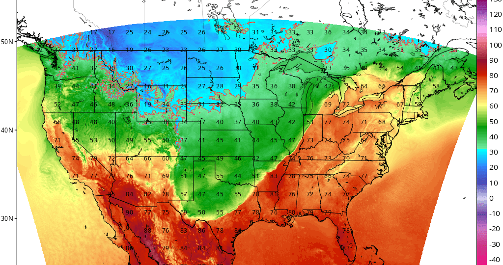
I have a theory. I think the October weather pattern repeats itself as the official winter weather pattern. I don't have data to back this up so that is what I will be paying attention to this winter. If this month is any indication of the future, expect a rollercoaster of a ride with above average temperatures followed by below average temperatures. Here is the current October trend: