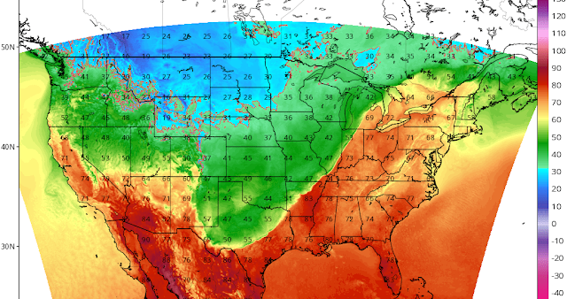
The Winter Weather Advisory has now come farther south to include us.

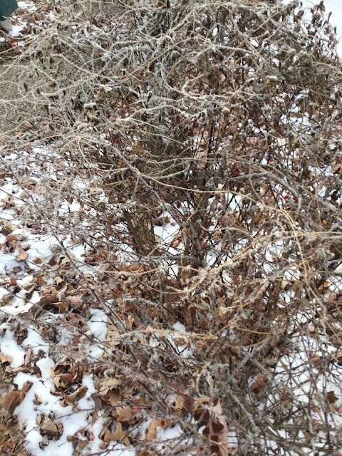
Ice ice baby!


I had no idea that you could still call a phone number for weather information. Wow! 
1-800-261-7623 

Winter Weather Advisory

URGENT - WINTER WEATHER MESSAGE
National Weather Service Indianapolis IN
937 PM EST Thu Dec 31 2020

INZ051>053-060>064-067>072-011100-
/O.EXA.KIND.WW.Y.0005.210101T0800Z-210101T1600Z/
Vigo-Clay-Owen-Sullivan-Greene-Monroe-Brown-Bartholomew-Knox-
Daviess-Martin-Lawrence-Jackson-Jennings-
Including the cities of Terre Haute, Brazil, Clay City, Spencer,
Sullivan, Linton, Bloomfield, Bloomington, Nashville, Columbus,
Vincennes, Washington, Loogootee, Shoals, Bedford, Mitchell,
Seymour, Brownstown, and North Vernon
937 PM EST Thu Dec 31 2020

...WINTER WEATHER ADVISORY IN EFFECT FROM 3 AM TO 11 AM EST
FRIDAY...

* WHAT...Freezing rain expected. Total ice accumulations of up
  to one tenth of an inch.

* WHERE...Portions of central, south central, southeast,
  southwest and west central Indiana.

* WHEN...From 3 AM to 11 AM EST Friday.

* IMPACTS...Difficult travel conditions are possible. The
  hazardous conditions could impact the morning commute.


PRECAUTIONARY/PREPAREDNESS ACTIONS...

Slow down and use caution while traveling. Prepare for possible
power outages.

The latest road conditions for Indiana can be obtained by
calling 1 800 2 6 1 7 6 2 3


More ice on the way for tonight.

If you are having a New Year's Eve party to ring in the new year, make some sleep-over plans. It's best not to drive after midnight. And please don't drink and drive in the icy weather. That is a terrible idea. 


.SYNOPSIS...
Issued at 345 AM EST Thu Dec 31 2020

Surface high pressure will lift northeast across central Indiana
today and provide a brief respite in the late year precipitation.
Things will change in a big way overnight tonight though as a strong
storm system lifts northeast out of Mexico. This system is expected
to result in several hours of freezing rain early New Year`s Day
before strong southerly flow warms things way up which will result
in a transition to moderate to locally heavy rain New Year`s day.

Aside from a small chance of rain and snow Saturday night associated
with another system, high pressure will result in dry weather with
slightly above normal temperatures through the middle of next week.

&&

.NEAR TERM /Today/...

Issued at 345 AM EST Thu Dec 31 2020

Today will see a break in the precipitation as surface high pressure
lifts northeast over central Indiana. However, dew points in the
lower 20s will help set the stage for icing tonight into New Year`s
Day. Dry punch should allow breaks in the clouds late morning and
afternoon. However, northeast and east winds will not allow the
temperature to recover too much with near normal highs in the middle
and upper 30s.

&&

.SHORT TERM /Tonight through Saturday night/...

Issued at 345 AM EST Thu Dec 31 2020

The year 2020 like it does not want to go down easy as it wants to
curse the start of 2021 with a glaze of ice as a strong upper
Mexican system will lift northeast into eastern Texas this evening
and into eastern Oklahoma overnight and into the Ozarks on New
Year`s Day before shearing out over the Great Lakes Saturday early.
Meanwhile, surface reflection lifts northeast across central Indiana
21z New Year`s Day to 03z Saturday.

Strong isentropic lift returns once again after 03z tonight from
southwest to northeast. BUFKIT soundings showing a classic freezing
rain sounding for several hours after the atmosphere saturates again
from top to bottom overnight into New Year`s Day morning. East and
northeast winds around the retreating surface high will keep the
near surface below freezing. The exception will be far southwestern
counties, where the temperatures may remain near, at or slightly
above freezing. Meanwhile, strong warm advection, deep moisture,
increasing low level jet and coupled 120 knot plus northern Great
Lakes and Lower Mississippi Valley jet streaks, will supply strong
forcing and the moisture needed to moderate precipitation overnight
and into New Year`s day. 30 millibar or less condensation pressure
deficits on the 300K surface, suggesting a saturated column, will
move from southwest to northeast across the forecast area. This all
suggests rain, possibly freezing, will move into Knox county around
06z. As the precipitation shield heads further northeast, most or
all of the precipitation will be freezing rain with a possible brief
mix with sleet or snow at the onset from evaporative cooling in
lowest levels prior to complete saturation of the column. This
precip shield should reach the metro area after 09z and far northern
counties around 12z.

Soundings and surface temperatures suggest most areas will see
around 4 hours of freezing rain, which will be moderate much of the
time, perhaps even locally heavy. This is an slightly gusty winds,
support ice accumulation amounts from around 0.05 inches in
southwestern sections to around 0.20 inches across northern
sections. After coordinating with local offices, decided to go with
a Winter Weather Advisory for freezing rain from 08z-16z New Year`s
Day from Vermillion county southwest to Decatur county and north.

The temperature will then warm above freezing from around 12z-16z
from southwest to northeast, so will likely be able to clear
counties on an hourly or so basis from southwest to northeast.

After that, the main focus will be rain. Models suggest a widespread
inch is possible before things wind down from southwest to northeast
as the systems shears into the Great Lakes. The strong forcing
mentioned early and low level jet increasing to 50 knots during the
afternoon, certainly supports locally heavy rain and possibly minor
low lying flooding.

It now looks like dry weather Saturday will be brief as the next
southern system lifts northeast across the area and becomes
negatively sheared as it does so. Deepening moisture and sounding
profile support a shot of rain and snow Saturday night with minor
snow accumulation possible.

The future is looking bleak for #BOTS fans.

We are on the warm and rainy side of every storm that passes through between now and January 16th. 


Golfing forecast for tomorrow.

If you are thinking about golfing tomorrow, you might want to tee off at 7:30am to avoid the rain. It will likely start raining by 12 noon. The temperature will be between 42 and 46 degrees so a nice sweater and a light jacket will be needed. Take the umbrella just in case.

Bad news for #BOTS fans.

I was just looking at some long-range data on temperatures for the month of January and it looks it will be slightly above average. Our best opportunity for snow is going to be between January 11-21st. That is the only sustaining cold period I see. Let's hope this is wrong.

#BOTS!

This week's weather is very complicated to forecast.

I would not trust any weather predictions for this week. Anything and everything are on the table this week. Here is the very verbose discussion from the National Weather Service:


.SHORT TERM /Tuesday through Thursday/...
Issued at 324 PM EST Mon Dec 28 2020

Forecast challenges increase throughout the forecast period as the
first part of a broad two part storm system impact the Ohio Valley
and Great Lakes beginning Tuesday night and continuing beyond the
short term into New Years Day.

Model guidance has come into better alignment versus the last couple
days and this may be at least partially due to the key features
being better sampled...namely the primary upper level energy now
onshore in California. This upper level trough will kick out east
into the southern Rockies through midweek and Texas by Thursday
before becoming a major factor locally with the second part of the
system for Thursday night into Friday. More will be discussed with
this feature and its impacts here in the long term discussion below.

Ahead of the western trough is an amplifying upper wave that will
drop out of the Canadian prairies late Tuesday into Wednesday before
shearing out across the Great Lakes Wednesday night as it remains
blocked by a strong ridge off the southeast coast. This feature in
tandem with a strengthening surface low tracking northeast from the
central Plains into the Great Lakes Wednesday will serve as the
basis for the first part of the storm system and its impacts over
central Indiana which will maximize Wednesday into Thursday.

First though...after a dry day but with a steady increase in mid and
high clouds Tuesday...a warm front extending from the surface low
will shift quickly across the northern half of Indiana late Tuesday
afternoon and evening. A thin axis of isentropic lift noted at 290K
and above will clip the northwest part of the forecast area and may
provide just enough lift to generate very light precip for a brief
period. The presence though of drier air through the boundary layer
may limit any precip to sprinkles or flurries. The axis of moisture
aloft and isentropic lift will shift north of the forecast area
quickly Tuesday evening with dry weather returning.

Focus then turns to the west and northwest as an axis of steady
rainfall approaches ahead of a cold front that will advance east
from the Mississippi Valley Wednesday morning into the forecast area
by late day. A combination of strong isentropic lift...broad
diffluence aloft and a 60kt+ low level jet will transport deep
moisture into the region with widespread rain developing Wednesday
morning and continuing for much of the day as the front works into
the region. The front will continue to progress southeast slowly
Wednesday night with precipitation continuing along it. As colder
air advects into the region from the north behind the front...there
remains some concern at areas of light mixing of precip types on the
northern flank of the rain...potentially with very light ice and/or
snowfall accums. With that being said...the presence of such wet
ground in wake of the earlier rain may mitigate much concern with
any issues from a wintry mix and any amounts are expected to remain
light through Thursday morning.

The front will shift south of the Ohio River on Thursday leaving
much of central Indiana within the backwash of the first system.
Model soundings and RH progs continue to keep plenty of moisture
over the region...and even as lower clouds depart through the course
of the day...they are likely to be replaced by thicker clouds aloft
as the second part of the system begins to organize to our
southwest. The result will be a relatively cloudy and chilly New
Years Eve for most with at least some potential for scattered light
precip focused over the southern half of the forecast area. Heavier
precipitation largely in the form of rain will then overspread the
region from the south late on New Years Eve as the second part of
the storm approaches. More on this in the long term discussion.

Temps...low level thermals support undercutting guidance on Tuesday
with highs mainly in the mid and upper 30s. The warmest day of the
week will be Wednesday as gusty southerly flow pushes temperatures
into the upper 40s and lower 50s. Highs will fall back into the 30s
on Thursday north of the front. Expect lows mainly from the upper
20s to the mid 30s through the period.

&&

.LONG TERM /Thursday Night through Monday/...
Issued at 324 PM EST Mon Dec 28 2020

The second part of this week`s complex system will be fueled by a
stacked and cut-off low pressure system`s advancement from the
southern Plains at the start of the period...northward up the
Mississippi Valley, and then across the Great Lakes to southeastern
Canada by the end of the weekend.  The system`s progressive nature
will be promoted by another, upstream H500 trough which will
meanwhile plunge into northern Mexico.  While the track of the
downstream system that will effect central Indiana will be dependent
on how these two circulations dumbbell around each other
Friday...ensembles are showing moderate/high confidence that the
system will begin it`s northerly approach west of the Mississippi
River.

While northern stream energy is very much absent from potentially
phasing with the stacked low, there will be some weak antecedent
chill in the lower levels courtesy the high pressure that will have
crossed into the Mid-West earlier Thursday.  While the high pressure
should not be strong enough to promote any long-duration/significant
snow...the easterly flow it will likely provide Thursday night as
chances of precipitation increase to likely POPs...may promote at
least a period of wet snow/wintry mix for much of the CWA before the
storm`s approach veers winds to a gusty southerly flow, ensuring an
only-rain event Friday morning.

Noteworthy are GFS peak PWAT values in the 1.0-1.3" range into early
Friday which are into record-high territory for early January.  A
reflection of a bit of a tropical feed being pulled up the east side
of the system and into the Mid-West, it introduces the potential for
over performance of rainfall rates and storm totals.  So did not
hesitate to keep likely rain late Thursday night/Friday AM for the
time being.  An additional 1.0-1.5" of total rainfall from this part
2 is possible for the entire region. Southerly gusts in the 20-30
mph range will likely accompany the period of heavier precipitation
as the storm system passes the region.

Following the system`s departure to our northeast, no organized
precipitation is expected for the weekend.  Partly cloudy skies and
seasonable chill should prevail, with a lack of any strong northern-
stream amplification promoting only light/moderate breezes.  For the
period, high temperatures will be in the mid 40s to low 50s New
Year`s Day...the mid 30s to low 40s for the weekend...and the 40s on
Monday. Overnight lows are expected to be in the upper 20`s to mid
30`s both Thursday and Friday nights...and 20`s Saturday night.


Bring an umbrella for New Year's Eve

We could see up to 3 inches of rain. If this were frozen it would 2.5 feet of snow but no such luck for us. Also, don't fall for any of the exaggerated snow maps on twitter or facebook. Here's what the NWS is saying:


It makes me want to cry!

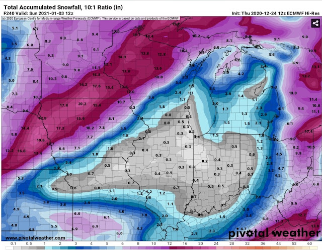
This is a picture of the Hi-res European wx computer model showing long-range predicted 10:1 snow totals from now through January 3, 2021. Why oh why? Poor old Indiana. Don't give up yet #BOTS fans.


#BOTS!

Light snow showers and flurries currently in Bloomington, Indiana. But hey,  we'll take what we can get right #BOTS fans?

I hate politics! I love weather! and #BOTS!

I guess you all have heard that the National Weather Service is receiving some backlash over the launch of its new wx radar. If you haven't heard about it, you can read an article in the Washington Post called,

"Weather Service faces backlash after launching slow, unusable radar website."

I've a met a few of the people that work for the National Weather Service office in Indianapolis because I have attended their severe weather training sessions for the last ten years. They are highly competent and professional but what they lack is funding, so, before we pass judgement on them we should consider that the current administration slashed the budget for the National Weather Service by 8% in 2018. To read more about the budget cuts, see the article posted by The Weather Channel called,

Trump Administration Proposes Slashing National Weather Service Budget by 8 Percent, Eliminating Hundreds of Jobs

Well, Happy Holidays and #BOTS! (Bring on the snow!)


Dreaming of a white Christmas?

Well, keep dreaming.
______________________

Issued at 215 AM EST Mon Dec 21 2020

The GFS and NAM show strong ridging building aloft over the
plains states in the wake of the departing short wave. This sets
up and excellent pattern for lee side subsidence across the
Mississippi and Ohio Valleys. Strong surface high pressure is
depicted to build across the plains tonight and push across
Indiana through Wednesday morning. Forecast soundings and Time
height show a very dry column as this system passes. Thus will
trend toward partly cloudy skies through Wednesday Morning. Given
the expected arrival of southerly flow on Tuesday and Tuesday
Night...will trend temps at or above NBM.

On Wednesday a strong cold front will approach Indiana. Aloft...a
deep upper low will push through the upper midwest and into the
Great Lakes. This nearly stacked system will drag the cold front
across Central indiana in the afternoon...with favorable forcing
dynamics and strong cold air advection in its wake. Forecast
soundings show deep saturation on Wednesday afternoon and evening
as the cold front passes...with the soundings being above
freezing. Thus Ptype on Wednesday and Wednesday Night will be rain
ahead of the front with plentiful warm air in place due to
southerly flow on Tuesday and Tuesday Night. Forecast soundings
dry out considerable in the wake of the front as the cold air
arrives overnight. Thus will trend toward a dry forecast at that
time.

&&

.LONG TERM /Thursday through Monday/...

Issued at 346 AM EST Mon Dec 21 2020

Following frontal passage on Wednesday night, unimpeded NW flow will
push an Arctic airmass into the Midwest and Ohio Valley. Even
with diurnal heating, efficient CAA will steadily drop
temperatures throughout the day with morning highs in the low 30s
and afternoon highs in the mid 20s. High temperatures in the mid
20s would be within the 10th percentile climatologically, but
this is supported by thickness values less than 5200.

With surface high pressure building underneath the CAA, dry weather
is likely to continue for the end of the week. With the vorticity
max centered over the Ohio Valley, some lingering cloud cover is
likely, although this should scatter by Friday morning. With lows
expected in the low teens and winds greater than 10 knots Friday
morning, wind chill values are expected to be in the single digits.

Another amplified trough will approach from the west over the
weekend, pushing temperatures back towards seasonal. A surface
disturbance looks possible towards the end of the period, but a
large distribution in location across ensemble members has lead to
lower confidence. Even so, some form of precipitation is possible 

late on Day 6 and Day 7. 

#BOTS! fans for children.

 #BOTS fans do not have to be for adults, they can also be for children. Look at these great children's books that I found.


Get ready for a wild roller-coaster ride.

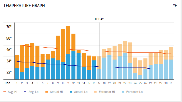
Temperatures are going to go from one extreme to the other. It looks like the cold air will mostly likely be sustaining from from January 2nd to the middle of January.

Wednesday 12-23.


Friday 12-25.


Thursday 12-31.


Saturday 1-2.


Notice the rise-and-fall pattern of temperatures relative to average in the charts below.


There's a chance we might see a White Christmas this year. The GFS and the Canadian models say yes.


For #BOTS fans we are looking at two small (2-inch) snow storms between now and New Year's Eve.


 Here's what the National Weather Service in Indianapolis says:

.LONG TERM /Sunday through Wednesday/...
Issued at 359 AM EST Thu Dec 17 2020

The weather next week will be a roller coaster. Starting
off with above normal temperatures and ending with a blast of arctic
air. Not to get too ahead of ourselves, but a white Christmas would
not be impossible either (and by white Christmas, we mean some snow
may fall within 48 hours of Christmas).

An upper wave will be making its way through the region at the
beginning of the period. Central Indiana is expected to stay dry,
with precipitation staying to the north of the area where better
forcing and moisture are. Ridging aloft will then move in, with
surface high pressure expanding into the area. This will then place
us under SW flow on the backside of the high which will bump
temperatures to above normal, reaching the mid 40s to near 50
degrees from Monday to Wednesday.

A large amplitude trough will impact the region towards the end of
the period which will bring precipitation ahead of it and cold
arctic air behind it. As this system is in the day 6 to 8 timeframe
there are a lot of uncertainties and models vary on their solutions.
For now, the timing of the precip looks to be sometime between
Wednesday night and Thursday night, starting out as rain and
transitioning to snow before the system exits to the east. The
question of whether or not portions of central Indiana will get a
white Christmas (again, we`re being over zealous with that phrase at
this time) lies with how the timing of the precipitation will align
with drastically colder air behind the front. There is a decent
consensus that the low temperatures on Christmas morning will be in
the upper teens with wind chills in the single digits. Much remains
to be seen, but we are saying there is a chance!


#BOTS fans get ready.

 The NWS is discussing snow chances for us next Tuesday night. Right now only minor accumulations are expected but I'll take it. #BOTS!

.LONG TERM /Tuesday Night through Saturday/...

Issued at 203 PM EST Sat Dec 12 2020

ECMWF shows a moderate short wave pushing through the region on
Tuesday night into Wednesday. An accompanying surface low is
depicted to push across southern Indiana while the 700mb low is
shown to push across the west central and northern parts of
Indiana. Forecast soundings on Tuesday night through Wednesday mid
morning show a saturated column with the entire column below
freezing. Thus given this pattern some minor accumulating snow
will be possible with this passing wave. Although timing and
position could change quite a bit through Tuesday...at this time
it could may for some snow falling during the Wednesday morning
commute. Thus will have to stay tuned on this one and continue to
monitor.

ECMWF then suggests strong and large high pressure building
across the region on Wednesday Night through Saturday in the wake
of the upper short wave. GFS forecast soundings appear to dry out
as a quick flow aloft provides little in the way of upper support.
Thus will keep a dry forecast on Thursday through Saturday Morning
for now.

The ECMWF shows a deepening area low pressure over the plains on
Saturday...placing Indiana in a SW surface flow ahead of this
system. At this time forecast builder has not caught on to this
feature...but given the upper support and the lower level
organization of the system...chances for precip in later
forecasts look like a good bet for next Saturday.

A much calmer week.

This looks like a much calmer week even on social media. The 'socials' are really quiet about any new snow this weekend. I wonder why? The National Weather Service has a small chance of snow this coming weekend from 20-30%. 

This week's high temperatures will be in the low to mid 40's while the low temperatures will be in the upper 20's to the low 30's, so just about seasonal. If anyone wanted to go golfing on Wednesday they should wear a sweater and carry a light jacket since the temperature will be 43 degrees.

All joking aside, I have already said that we will not see any snow until mid December and I think that is about right; ...like the kind of snow that actually sticks to trees and cars and cats and stays on the ground for an hour or more; that kind of snow. The snow we had on Monday was hardly noticeable.

I would say pay most attention to December 15 - 25.

Here is what the NWS says:

.LONG TERM (Friday Night Through Tuesday)...
Issued at 212 PM EST Tue Dec 1 2020

As with the past several days, models continue to have differences
between each other and within themselves on the handling of an upper
low and its associated surface low early in the long term period.
The long term upper flow remains complex with numerous upper lows
moving about.

The farther north models have precipitation into the area while the
farther south ones do not. Operational GFS and ECMWF are pretty dry
for central Indiana, while the ensemble means of those models have
some rain into the area.

The result is a low confidence forecast. Given the high uncertainty,
complexity of the upper flow, and not wanting to flip flop too much,
only went low PoPs Friday night through Saturday evening.

Remainder of the forecast is dry for now.

Temperatures will remain near or a little below average for early
December with no strong pushes of cold air into the area.

Old lessons learned again.

What a difference three days can make. On Wednesday everyone was nearly sure of a blizzard and +6 inches of snow would hit Indiana and now we are lucky to get one inch of snow. The storm shifted to the east and will hit Ohio and Pennsylvania. 

This is a classic case to help remind you that storms are not predictable until 48 hours in advance. Long range forecasts of 5 or 7 or 10 days out are unreliable and especially in the winter.

To the people that watch computer models, remember that they are only guidance, not forecasts.

Here is a snow map that has Bloomington with less than one inch. Ha! Three days ago we were supposed to get 6 inches of snow. 


Ha! Computer models shift storm to the east.

Just as I thought. The "Blizzard" that people were talking about on twitter two days ago has shifted east into Ohio and Pennsylvania.


Blizzard talk is highly irresponsible.

If you've lived in Indiana long, you know that the weather changes frequently here. It's highly chaotic. Nothing is a 100% sure bet. That's the main reason I love talking about the weather. Let's wait and see what the computer models say tomorrow; likely sunny and a heat wave.

Notice the caveat at the top:


No snow until mid December.


Did you hear about a chance of wintry mix tonight?


Hazardous Weather Outlook

Hazardous Weather Outlook
National Weather Service Indianapolis IN
541 AM EST Mon Nov 23 2020

INZ021-028>031-035>049-051>057-060>065-067>072-241045-
Carroll-Warren-Tippecanoe-Clinton-Howard-Fountain-Montgomery-Boone-
Tipton-Hamilton-Madison-Delaware-Randolph-Vermillion-Parke-Putnam-
Hendricks-Marion-Hancock-Henry-Vigo-Clay-Owen-Morgan-Johnson-Shelby-
Rush-Sullivan-Greene-Monroe-Brown-Bartholomew-Decatur-Knox-Daviess-
Martin-Lawrence-Jackson-Jennings-
Including the cities of Delphi, Flora, Williamsport, West Lebanon,
Lafayette, West Lafayette, Frankfort, Kokomo, Attica, Covington,
Veedersburg, Crawfordsville, Lebanon, Zionsville, Tipton, Fishers,
Carmel, Noblesville, Anderson, Muncie, Winchester, Clinton, Newport,
Rockville, Greencastle, Plainfield, Brownsburg, Danville,
Indianapolis, Greenfield, Cumberland, New Castle, Terre Haute,
Brazil, Clay City, Spencer, Martinsville, Mooresville, Greenwood,
Franklin, Shelbyville, Rushville, Sullivan, Linton, Bloomfield,
Bloomington, Nashville, Columbus, Greensburg, Vincennes, Washington,
Loogootee, Shoals, Bedford, Mitchell, Seymour, Brownstown,
and North Vernon
541 AM EST Mon Nov 23 2020

This hazardous weather outlook is for central Indiana.

.DAY ONE...Today and Tonight.

Outlook: Chance of a light wintry mix in some areas late tonight.

Hazards: Wet roads.

Timing: After 2 AM.

Discussion: There will be a chance for precipitation late tonight,
some of which could fall as a wintry mix in spots. Relatively warm
ground temperatures should limit any impact and keep roads from
becoming more than wet.

.DAYS TWO THROUGH SEVEN...Tuesday through Sunday.

Outlook: Heavy rain will be possible at times late Tuesday night into
Wednesday. This could cause localized flooding.

Discussion: Another low pressure system will move through the area
mid week, bringing another round of widespread rainfall which may
produce some minor flooding.

.SPOTTER INFORMATION STATEMENT...

Spotter activation is not anticipated.

Wow! Four distinctive lines moving through.

The cold front that is approaching has set off numerous warnings in northern Illinois. As the front approaches it is supposed to lose power and it will. But look at how many times the line has redeveloped. This is the first time I've ever seen four distinct lines associated with a cold front.


Five might be pushing it too far but what do you think of this?


A warm pattern is in place for now.

We are in a la nina type winter which might prove to be a wild ride this upcoming winter. For now though, the pattern looks slightly warmer than average for the next ten days and maybe beyond due to the persistent southeast ridge and nonstop tropical / hurricane systems to our south. Here's what the National Weather Service says:

.SHORT TERM...(Tonight through Friday night)
Issued at 300 AM EST Wed Nov 4 2020

A weak upper trough will continue its approach tonight and then move
through Thursday. Any forcing with this trough will be weak. Most of
the moisture with this system will be at or above 500mb. Thus expect
only clouds with this system. Skies will become partly to mostly
cloudy tonight into Thursday.

These clouds will keep temperatures up tonight and will keep
Thursday`s temperatures from getting quite as warm as today (but
still above normal with no change in airmass).

Upper ridging will return after the trough passes, and high pressure
will remain in control at the surface Thursday night into Friday
night. The atmosphere will be dry once again, so expect mostly clear
conditions. Above normal temperatures will continue again with no
change in airmass.

&&

.LONG TERM (Saturday through Tuesday)...
Issued at 300 AM EST Wed Nov 4 2020

A strong upper level ridge and surface high pressure will gradually
begin to break down Saturday into early Sunday as a seasonably
strong upper level trough tracks across the Rockies into the
Northern Plains.  The only impacts to central Indiana from this
system will be some increased cloud cover Saturday night into Sunday
as Gulf air begins to advect into the area. As this first trough
exits, a secondary trough is expected to move across the Central
Plains Monday through Wednesday with small chances for rain across
central Indiana starting Tuesday morning with better chances during
the afternoon and evening hours. In addition, record high temps are
possible Sunday and Monday before the upper level system arrives.

Confidence remains quite low in timing for chances for rain and
whether anything impacts central Indiana on Tuesday vs later in the
week. The deterministic and ensemble guidance is struggling to
handle the two aforementioned troughs with how quickly they exit the
Rockies and how strong surface cyclogenesis is as they move into the
Plains. Chances for thunder currently look too low for a mention in
the forecast, especially with how low confidence is on timing and
strength of the low.  Pressure gradients do though look strong
enough for gusty winds, especially into Tuesday with widespread
gusts to 25 mph likely.

Temperatures will be much above average through the period.

Also, check check these out:


Here is my interpretation of the storm track that is setting up.


The tropical storms keep on coming.

 The hurricanes and tropical storms are taking over winter and keeping us warm. Welcome Tropical Storm Zeta.

A week from this coming weekend we get two more of them at the same time.


Rain and storms on tap for today.

 Most people tend to forget about this but we have two severe weather seasons in Indiana. One is in the spring and the other is in the fall. Currently, we are under a marginal risk for sever weather today.


#BOTS alert for next week.

 #BOTS fans should pay attention to next week and on Halloween. The National Weather Service in Indianapolis has this to say:

.LONG TERM /Sunday through Wednesday/...
Issued at 345 AM EDT Thu Oct 22 2020

Although, the forecast will start off with unsettled weather Monday
and Monday night as strong southeastward expanding Canadian high
forces yet another cold front southeast across central Indiana. Deep
moisture and moderately strong dynamics, including the area being in
the right rear quadrant of a 140 knot upper jet over southern
Ontario, suggests widespread and then good chance PoPs in the wake
of the cold front Monday and Monday night.

After that, not a lot of forcing as weakening Canadian high pressure
builds in. That said, would not rule out a shower or midweek with
cyclonic flow overhead.

Finally, late in the long term, the eyes will be focusing on a
potent upper vortex, that will be an early cold season wintry
weather maker over the southern Plains. At this point, the GFS is
trending way to fast so, so much so that even the GEFS is
discounted. Prefer the slower ECMWF and ECENS, that typically verify
better with these early cold season harbingers. That said, the blend
was painting small PoPs through most of the rest of the long term
and if there is precipitation around during the pre-dawn, some brief
non-accumulating snow could briefly mix in over northwestern
sections of central Indiana starting Monday night.

In general, thick cloud cover and thermals support 5 to 10 degree
below normal blend temperatures with afternoon highs mostly in the
50s and overnight lows in the 30s.

Do you want to know how to spot a cold front?

 Try this for an example.


Do you see it?


From warm to cold to warm again.

LONG TERM /Tuesday through Friday Night/...

Issued at 341 AM EDT Sat Oct 17 2020

Synoptic setup early in the extended period consists of a stationary
frontal boundary extending from the Southern Plains northeastward
through the Ohio Valley and into New England.  This will provide
some weak forcing across the southeast two-thirds of central Indiana
early Tuesday for low rain chances.  Moisture will be limited
though, and all of central Indiana is progged to be dry by Tuesday
afternoon.  Nonetheless, there will be a quick uptick in rain
chances from Tuesday night into Wednesday when a surface frontal
system moves through with a 50-60 kt low level jet in its warm
sector. Meanwhile, weak troughing aloft will move through the
Great Lakes Region. After that though, any upper forcing will
be limited until late in the extended period when the next trough
moves through from Thursday night through Friday night. So, any
low precipitation chances from Wednesday night through Thursday
will only be fueled by a lingering surface frontal boundary, and
these chances are low confidence.

Meanwhile, strong warm advection in the aforementioned warm sector
will bump daytime highs into the upper 60s/low 70s on Wednesday
and even low to upper 70s on Thursday. The cooler weather,
however, will return over the weekend after a cold front drifts
through central Indiana.

Fun and games start next week!

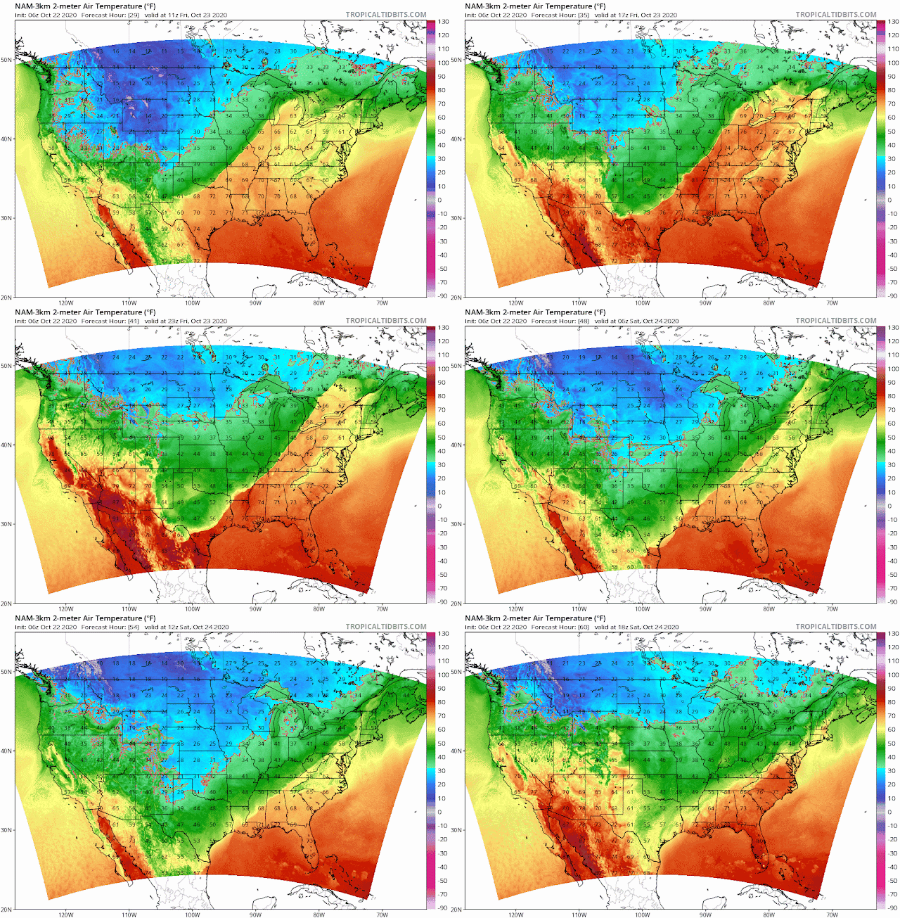
This is not a forecast. It's just a reminder that we are entering that time of year again when frozen precipitation starts to show up in the Ohio Valley as we approach November. Enjoy the eye candy.


Frost and freeze warnings are out for Monroe County Indiana


Freeze Warning

URGENT - WEATHER MESSAGE
National Weather Service Indianapolis IN
335 AM EDT Thu Oct 15 2020

INZ021-028>031-035>049-051>057-060>065-067>072-151545-
/O.NEW.KIND.FZ.W.0007.201016T0600Z-201016T1400Z/
Carroll-Warren-Tippecanoe-Clinton-Howard-Fountain-Montgomery-
Boone-Tipton-Hamilton-Madison-Delaware-Randolph-Vermillion-Parke-
Putnam-Hendricks-Marion-Hancock-Henry-Vigo-Clay-Owen-Morgan-
Johnson-Shelby-Rush-Sullivan-Greene-Monroe-Brown-Bartholomew-
Decatur-Knox-Daviess-Martin-Lawrence-Jackson-Jennings-
Including the cities of Delphi, Flora, Williamsport,
West Lebanon, Lafayette, West Lafayette, Frankfort, Kokomo,
Attica, Covington, Veedersburg, Crawfordsville, Lebanon,
Zionsville, Tipton, Fishers, Carmel, Noblesville, Anderson,
Muncie, Winchester, Clinton, Newport, Rockville, Greencastle,
Plainfield, Brownsburg, Danville, Indianapolis, Greenfield,
Cumberland, New Castle, Terre Haute, Brazil, Clay City, Spencer,
Martinsville, Mooresville, Greenwood, Franklin, Shelbyville,
Rushville, Sullivan, Linton, Bloomfield, Bloomington, Nashville,
Columbus, Greensburg, Vincennes, Washington, Loogootee, Shoals,
Bedford, Mitchell, Seymour, Brownstown, and North Vernon
335 AM EDT Thu Oct 15 2020

...FREEZE WARNING IN EFFECT FROM 2 AM TO 10 AM EDT FRIDAY...

* WHAT...Sub-freezing temperatures as low as 30 expected.

* WHERE...Portions of central, east central, north central,
  south central, southeast, southwest and west central Indiana.

* WHEN...From 2 AM to 10 AM EDT Friday.

* IMPACTS...Frost and freeze conditions will kill crops, other
  sensitive vegetation and possibly damage unprotected outdoor
  plumbing.

* ADDITIONAL DETAILS...Rural areas and favored colder spots may
  see temperatures fall into the upper 20s.

PRECAUTIONARY/PREPAREDNESS ACTIONS...

Take steps now to protect tender plants from the cold. To prevent
freezing and possible bursting of outdoor water pipes they should
be wrapped, drained, or allowed to drip slowly. Those that have
in-ground sprinkler systems should drain them and cover above-
ground pipes to protect them from freezing.

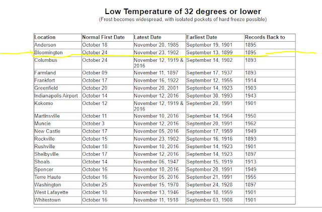


Some eye candy for all the #BOTS fans out there.

This likely will not happen but it's great to see the GFS kick out a random snow event in our area this early.


Burl's Winter Weather Theory

Winter officially begins on Monday, December 21 at 5:02AM EST. 

Unofficially, meteorological winter starts on December 1 and ends on February 28.

I have a theory. I think the October weather pattern repeats itself as the official winter weather pattern. I don't have data to back this up so that is what I will be paying attention to this winter. If this month is any indication of the future, expect a rollercoaster of a ride with above average temperatures followed by below average temperatures. Here is the current October trend:


It's officially autumn.

 And 89 days until the winter solstice. 

I don't see any rain chances until September 30 to October 4. That's about it.

October 1st and 2nd will be cold at night. It looks like anywhere from 38-40 degrees.

Fall - part 2

It going to feel a lot like fall this weekend. Friday and Saturday night's low temperatures will get down to 45 degrees. The high temperatures will be 68. Get out and enjoy it with your mask on.

Because of our drought situation, this causes the leaves change colors and fall early on.


North Washington Street facing south.