It looks like we'll have everything thrown at us except the kitchen sink tonight (unless you live in Bedford). If you haven't heard, this is our first round of severe weather and spring has not officially started yet. See the bottom portion of this post for what the National Weather Service in Indianapolis is saying. Keep reading to see what I think.
I think a cold front is moving in and it is attached to the northern polar jet. The southern tropical jetstream continues to bring in warm air from the south. It looks like they will collide over southern Indiana and Kentucky tonight between 7pm and 3am. Tornadoes are possible. In fact, I saw a sounding that has a tornado right over Bedford, Indiana. The coordinates in the sounding are here.
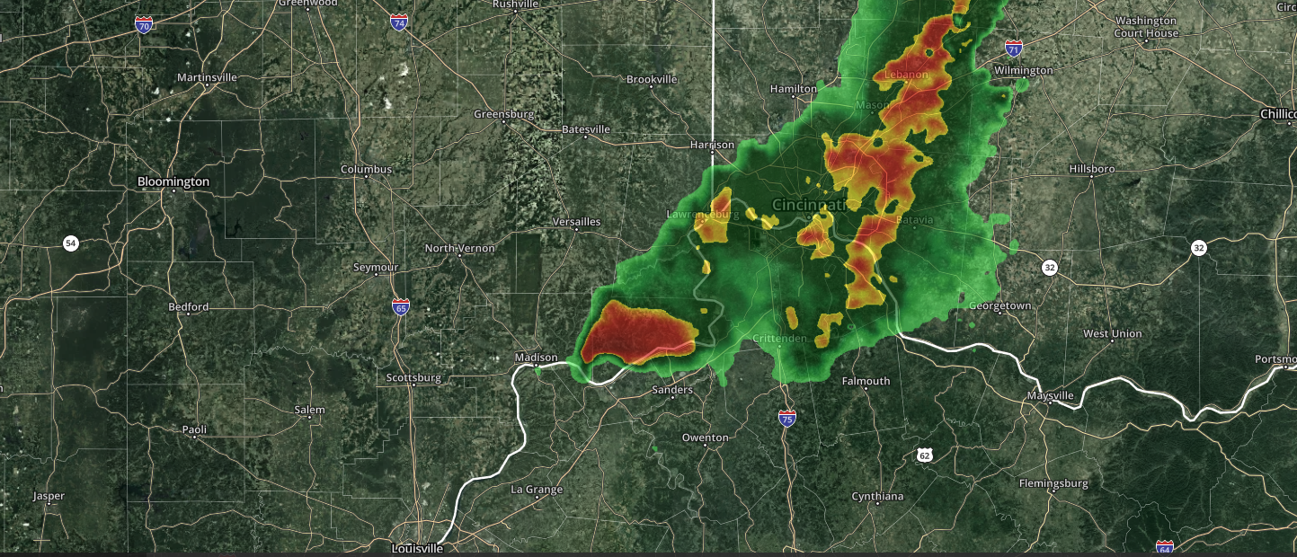
Here is a good visual representation of the colliding air masses.
And then it looks like we get to experience this again around March 5, 2024.
If you think winter is over, think again. Check out this CFS forecast for March 29, 2024
So here is what the NWS is saying:


Area Forecast Discussion
National Weather Service Indianapolis IN
1142 AM EST Tue Feb 27 2024

.Key Messages...

- Record High Temperatures possible today
- Strong to possibly severe weather this evening and overnight
- Gusty winds this evening and overnight
- Cold front arrives early Wed with brief shot of light snow
- Warm temps return for the weekend

&&

.Forecast Update...
Issued at 956 AM EST Tue Feb 27 2024

Conditions are evolving as expected so far this morning following
pre-dawn convection along the Ohio Valley and a few small showers
passing west to east around the Spencer/Bloomington areas over the
past couple hours.  993 mb surface low pressure currently positioned
near the Twin Cities will drag its trailing surface trough/
pronounced cold front east across the Middle Missouri Valley today
and into northwestern Illinois by 00z this evening.

Central Indiana will continue to bask in the system`s warm sector,
with today`s record high of 73F in jeopardy...and surpassing today`s
record high maximum of 51F from 1876 likely a slam dunk through
midnight tonight.  Considerable cloudiness and anomalously high
dewpoints now in the 55-60F range over the entire state will both
inhibit the stronger warming rates seen yesterday...yet suspect
continued WAA amid southerly gusts approaching 25-30 mph by early
evening will boost readings to 70-75F by late day across the CWA.

All convective parameters are exhibiting a potent severe potential
across the region, with very high vertical wind shear over both 0-6
km and lower levels, impressive 700-500mb lapse rates, and more than
adequate instability that should be blossoming through afternoon
hours, especially north and west of the Indy Metro...albeit mostly
elevated through daytime hours.  Very latest guidance continues to
delay convective initiation until this evening with a perhaps subtle
yet key inversion lingering within the 750-850 mb layer.  Widely
scattered showers cannot be ruled out at times through the daytime
hours but suspect organized thunderstorm activity to hold off until
overnight hours...following removal of inversion aloft ahead of
approaching frontal zone.  We will continue to watch and update this
dynamic situation throughout the day and tonight.

&&

.Short Term...(Today and tonight)
Issued at 256 AM EST Tue Feb 27 2024

Early this morning...
Impressive moisture feed across the Ohio Valley, with several
locations early this morning seeing dewpoints rise from the upper
30s to near 50 degrees. A meso-sector for satellite data has been
setup over a portion of the Ohio Valley/Mid-Mississippi valley and
is depicting a feed of water vapor east lifting northeast across the
region. Aircraft soundings indicate the deeper moisture is still
elevated at 600mb and above with a dry layer beneath this until the
inversion around 850mb. Low clouds were initially progged to be
expanding northeast across the area have been sluggish to expand in
coverage, but latest surface obs indicate several locations upstream
are beginning to see this development of a stratus deck. Winds in
the near sfc layer or 0-1km show southerly flow rather uniform with
very subtle deviation in the direction, and speed it also uniform
between 10-15kts and gusts 15-20kts during pre-dawn hours. Some
elevated reflectivity was showing up throughout Central Indiana
extending west into Illinois, but this coverage is minimal and not
reaching the ground at this moment. At 7Z the 925-850mb moisture
transport footprint has grown with the highest values over
Arkansas/Western KY/TN. This places the best gradient over Northeast
Missouri where reflectivity has been expanding along the better
vertical momentum. Current wind fields would suggest propagation to
this area of precip would slowly slide northeast, but as eluded too
earlier about aircraft soundings showing a dry wedge it may only
moisten partially this layer later this morning.

Midday... The big challenge for the afternoon will be how warm sfc
temps can become as the sensible layer sees a surge in increase
moisture. Which should slow the rate of warmth, shallow cloud layer
will also play a pivotal role in max temps. But given the delay in
precip development and the continued warm air advection progged, we
should easily push temps back into the low 70s especially with temps
pre-dawn starting in the low.

Main concern for this afternoon into the evening will be focused
with convective development. Looking at the setup a robust 300mb jet
streak is progged to be positioned to the southwest of Central IN,
placing the area within the exit region. This typically favors
diffluent flow aloft, and thus in the lowest layers presence of
upward motion. The limiting factors with the afternoon setup are the
fact that Central IN may not be seeing the stronger sfc convergence
due to more uniform wind fields from the south. A 7Z aircraft
sounding indicates the inversion developing above the mixed layer,
which guidance is now indicating will linger through much of the
day. So despite an EML and favorable lapse rates of 7.5 to 8 C/km
this afternoon, should this warn nose aloft remain for much of the
day the convective footprint and upscale growth could be minimal.
Should the shallow layers warm enough to erode the inversion then
considerable MLCAPE in excess of 1500J/kg and effective shear within
the 0-6km layer over 45kts would set the stage coupled with the
aforementioned upper level jet to see robust upscale growth to
convection by late afternoon leading to damaging wind/large hail and
even a tornado. While the forecast is slightly more complicated, the
potential remains for severe weather and thus the entire area
remains in a slight risk for today.

The upper level jet appears to drift further north, likely a result
of the downstream height rises helping to slow the forward
progression to the approaching mid-lvl trough. This will help to
further sharpen the frontal boundary that will be approaching from
the west late in the overnight hours. Sfc low will be zipping north
into lower Michigan as the trailing cold frontal boundary will be
stretching southwest through East Central IL by 6Z Wed. There
remains some uncertainty tonight with how convection evolves as
guidance has backed off on the convective footprint. Still some
guidance indicates perhaps more linear segments develop. The
atmosphere will still be conducive to seeing severe storms with the
potential for slightly backed sfc winds aiding in the 0-1km helicity
fields, which would support a risk for isolated rotating updrafts
from the linear segment of convection pre-frontal passage. This
focus would be along and east of Vincennes to Indy line.

&&

.Long Term...(Wednesday through Monday)
Issued at 256 AM EST Tue Feb 27 2024

Wednesday and Wednesday night...

The long term will start off with temperatures taking a nose dive in
the wake of a strong cold front that models agree will be from
around in between Toledo and Cleveland to just east of Cincinnati at
12z Wednesday. This will put a temporary exclamative kibosh on the
near record temperatures we experienced yesterday and will once
again today. To illustrate how fast temperatures will fall during
the day Wednesday, model 850 millibar temperatures at 06z Wednesday
have a ridge of 13 to 15 degree C temperatures over central Indiana
and by 18z Wednesday, 850 millibar temperatures are -11 degrees C
over southeastern sections and -14 degrees C over northwestern
sections. In addition, with the upper trough still the west and
moisture slow to move out, the lingering showers will quickly mix
with and change to snow before it moves southeast out of central
Indiana by 18z. With deep moisture and lift through the Dendritic
Growth Zone, a quick dusting of snow is possible over mainly grassy
areas as the ground will start off well above freezing from the two
prior abnormally warm days. High confidence with this setup that
high temperatures will be right at 12z with temperatures falling
through the 30s and 20s during the day. In addition, tight surface
pressure gradient in the wake of the front will result in windy
conditions with northwest winds gusting to 40 mph. This will make it
feel like even more of a shock to the system as Wind Chills drop
into the teens during the evening.

Thursday through Friday night...

A surface high will move across central Indiana Thursday. As it
moves east of the area, during the afternoon, temperatures will
start their rebound as low level flow shifts to the south. A dry
column per BUFKIT soundings will allow for plenty of sunshine and
low level thermals support temperatures to rebound to the upper 30s
to middle 40s Thursday afternoon. Although an upper wave will move
across late Friday which will bring more clouds in and potentially a
few rain showers to mainly southern sections closer to better
moisture, continued warm advection courtesy of breezy southerly
winds will allow temperatures to climb a few more degrees into the
middle and upper 40s, which is near normal for the first day of
March.

Saturday through Tuesday...

The weekend will be looking up for outdoor enthusiasts as continued
warm advection ahead of a potent and broad western system will once
again result in mostly benign weather and temperatures some 15 to 25
degrees above normal.