There are extreme weather graphics being posted to #INWX. Don't believe them!
https://twitter.com/hashtag/inwx?f=tweets&vertical=default&lang=en
A radar return from last night's storm system.
I've never seen this before. Storms were elongated from south to north when we were on the warm side of it. If you heard the wind last night, you could imagine how this could happen.


Dear #BOTS fans:
I am sorry to be the bearer of sad news, but our grandfather Old Man Winter passed away last Saturday from complications of a negative PNA pattern and a positive NAO pattern. He had been experiencing these symptoms for several weeks. The the polar vortex was intended to alleviate the problem but failed.
Following his wishes, we held a graveside service with at the Winter family plot in the Springfield City Cemetery. Old Man Winter was a modest, private man and wanted it that way. He is survived by his two melting children; Snow-man and Snow-woman.
______
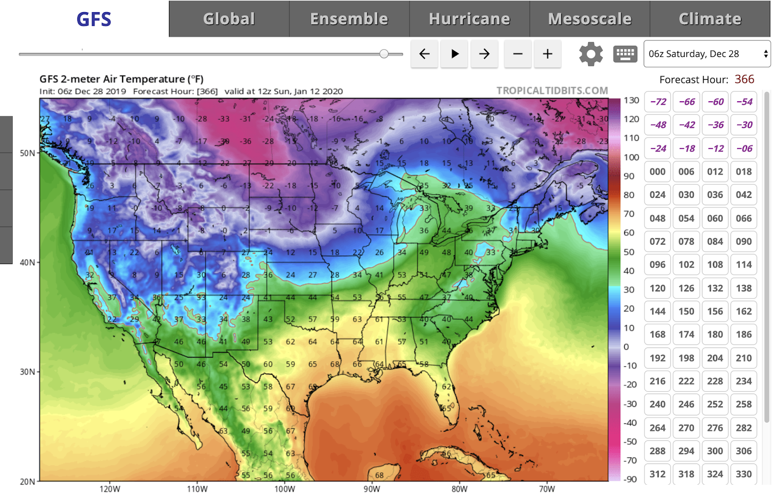
Check out the above average temperatures for the next two weeks.


Following his wishes, we held a graveside service with at the Winter family plot in the Springfield City Cemetery. Old Man Winter was a modest, private man and wanted it that way. He is survived by his two melting children; Snow-man and Snow-woman.
______
Check out the above average temperatures for the next two weeks.

From the NWS:
LONG TERM /Tuesday through Friday Night/...

Issued at 352 AM EST Sat Dec 28 2019

After a few lingering rain and snow showers (NE third of central
Indiana) early Tuesday, high pressure will strengthen over the
region, and dry conditions can be expected late Tuesday through
Wednesday. Meanwhile, a weak warming trend will commence through
the period. High temperatures will start out in the upper 30s/low
40s on Tuesday and increase to the upper 40s/low 50s by Friday.
Overnight lows will also climb from the 20s on Tuesday night to
mid 30s by Friday night. After the dry period, focus will then
turn to the next system approaching from the southwest late in the
period, which will bring a more active pattern through the end of
the forecast period with chances for mainly rain showers and some
snow showers from Wednesday night through Friday.
Cold Thursday morning and then a warming trend.
Expect above average temperatures for the second half of the month.


Good news and bad news for the long term.
The good is that temperatures will be above average from December 20th to the 31st. The NWS 6-10 day outlook looks like this:


The bad news is that #BOTS fans will not see a white Christmas.

And NWS 8-14 day outlook looks like this:

The bad news is that #BOTS fans will not see a white Christmas.
12/17 Tuesday morning commute will be icy.
Get up early and use caution when driving tomorrow morning. Drive slowly and leave 2-3 car-length spaces between you can the car in front of you. And please don't be lazy; clean the damn snow and ice off the top of your car. That can injure someone or damage another person's vehicle when it gets blown off onto the traffic behind you.
B.
B.


These guys again!

This is America. If you want to pay for a weather forecast, you can. That's your prerogative. I wouldn't do it because I trust the professionals at the National Weather Service and they provide weather predictions for free. And, there's a whole host of other free websites and apps for Android and Iphone that will do the same thing. All the data comes from the National Weather Service. Everything else is mere, conjecture, art and interpretation.
Now, that's not to say that these people are not professionals. They are. They hold professional degrees in meteorology. But, I would never pay for a weather forecast when you have the experts at the National Weather Service giving it to you for free. That's just MHO.


St. Louis NWS has the best take on winter forecasting.
The National Weather Service in St. Louis published this regarding next week's *possible* snowstorm:


A snowstorm next week?
Ahhh, maybe. It's way too early to tell. The models have been going back and forth. At this distance we have an equal chance of seeing a rainstorm.

From the NWS:

From the NWS:
.LONG TERM /Saturday through Tuesday/...
Issued at 240 AM EST Wed Dec 11 2019

A Pacific Northwest system and a combination of a southern inverted
surface trough and another upper Pacific system will bring chances
for rain and or snow showers to the area this weekend into early
next week. The best chances per the blend look to be Saturday with
the first system and next Monday and Monday night with the second
one. Confidence in exact timing and coverage is not great, so will
lean on the blend until the systems get closer and the picture looks
clearer.

Low level thermal progs and expected cloud cover support slightly
above normal temperatures on Saturday and below normal temperatures
thereafter. Blend highs in the 40s on Saturday and 30s the rest of
the long term look reasonable.
#BOTS Fans.
What do you think of no snow for Indiana? Doesn't this look cruel?

Luckily this is the CFS model which is notoriously unreliable so maybe the opposite will happen.

Luckily this is the CFS model which is notoriously unreliable so maybe the opposite will happen.
The pattern seems to be locked in.
Well folks, the pattern seems to be set. This will be a quiet week. I don't see anything happening until Sunday night when there's a 40% chance of rain.
The overall pattern appears to be locked in. It goes a little something like this: A warm front approaches and brings a high wind storm and rain ahead of a strong cold front. Then the arctic air attacks and changes the rain to snow. The arctic air hangs out for a while and then retreats. Then it warms up before the next wind storm and rain arrives. As they say, "Wash, rinse, repeat."
Here's an example of what I mean:

Here's the latest discussion from the National Weather Service:
LONG TERM /Saturday through Wednesday/...

Issued at 304 AM EST Wed Dec 4 2019

Dry weather is expected to start the period with chances for rain
beginning late this weekend into early next week. Surface high
pressure will be weakening during the day Saturday ahead of a
surface cold front that will be approaching the area. Chances for
rain begin Sunday afternoon in as southerly winds advect
seasonably warm and humid air into central Indiana. Chances for
rain increase into Monday as the gulf moisture interacts with the
aforementioned surface cold front.

Current thoughts are the best chances for rain will be late
Sunday into Monday when forcing out ahead of the front is expected
to be strongest with the heaviest axis of rain south of the
forecast area. Small chances for rain continue into Tuesday with a
possibility of a rain/snow mix during the day Tuesday which be
dependent on how quickly the cold front exits the area and
precipitation ends. Dry conditions are expected for Wednesday
with strong cold air advection bringing the coldest temperatures
of the period.

Temperatures are expected to be above average Saturday through
Monday with below average temperatures Tuesday and Wednesday.
The weather pattern is locking in.
Here's a quick update.
Expect rain on Tuesday and into Wednesday.
There will be tremendous winds on Wednesday. I'm seeing gusts of up to 60MPH. A high wind watch has already been posted so get ready.
Thanksgiving looks somewhat safe with a 50% chance of light rain.
An arctic outbreak looks likely between December 7th and 10th.
The winter pattern looks to be shaping up this way: Storms develop over Colorado and track off to the north-east while riding the leading edge of advancing cold air.

Calm and quite for the next two weeks.
Temperatures will SLOWLY warm up over the next two weeks. I don't see any snow chances. The pattern looks very quiet until November 29th. After that it looks like the pattern will begin to reload with the *potential* for fresh arctic outbreaks. If that fails to happen, I would expect December to be warm than normal and then turn colder towards the end of December and in to January. Stay tuned...
A taste of winter in November.
It's 11 degrees outside right now. That will also be the low temperature for tonight.


According to my measurements, we received two to two-and-a-half inches of snow.


#BOTS Fans!
Wooooo hooooo! I know #BOTS fans are happy. I honestly thought we would only see an inch of snow on grassy areas given how warm and sunny it was yesterday. What a nice surprise.
Please be very careful tomorrow morning into Wednesday morning. Wind chills will be in the single digits. Drive safely and dress in layers.
Send pictures if you have them and want to share them. Here's what I took after work today:


Please be very careful tomorrow morning into Wednesday morning. Wind chills will be in the single digits. Drive safely and dress in layers.
Send pictures if you have them and want to share them. Here's what I took after work today:


The cold front makes it to Bloomington but it's too late
Look at the northern edge of Monroe County on the weather map.


Bad news.
I'm sorry folks but I've got the "bad news blues".
For #BOTS fans: Despite what you see on twitter and facebook, the National Weather Service is not forecasting snow in Monroe County Indiana for Thursday, 11-7-19.
For Fall-weather fans: Forget it! Next week is going to feel more like January than fall so brace yourself. Check the air pressure in your tires. Check your car battery. Keep an ice scraper and a winter coat handy. Get ready! Here's the last discussion from the National Weather Service:
And for all of us: The damn crows are back!


For #BOTS fans: Despite what you see on twitter and facebook, the National Weather Service is not forecasting snow in Monroe County Indiana for Thursday, 11-7-19.
| NWS Forecast for: Bloomington IN Issued by: National Weather Service Indianapolis, IN Last Update: 6:45 pm EST Nov 6, 2019 | |
| Tonight: Showers likely, mainly between 9pm and 2am, then rain likely after 2am. Cloudy, with a low around 37. Calm wind becoming north 5 to 7 mph after midnight. Chance of precipitation is 70%. New precipitation amounts between a tenth and quarter of an inch possible. Thursday: A 50 percent chance of rain before 2pm. Cloudy, then gradually becoming mostly sunny, with a high near 42. North wind 9 to 11 mph, with gusts as high as 21 mph. New precipitation amounts between a tenth and quarter of an inch possible. Thursday Night: Mostly clear, with a low around 21. North northwest wind 6 to 9 mph. |
For Fall-weather fans: Forget it! Next week is going to feel more like January than fall so brace yourself. Check the air pressure in your tires. Check your car battery. Keep an ice scraper and a winter coat handy. Get ready! Here's the last discussion from the National Weather Service:
.SYNOPSIS...
Issued at 326 PM EST Wed Nov 6 2019

Clouds will continue to increase over the rest of the day as a
weak cold front approaches the area. Rain has begun to move into
the southwest counties and will continue to spread over much of
the state by tonight. A few snowflakes will be possible early
tomorrow as the front exits the area with dry weather expected
through the weekend. Another front is expected to move through
early next week bringing chances for precipitation and the coldest
air of the season.

&&

.NEAR TERM /Tonight/...

Issued at 326 PM EST Wed Nov 6 2019

Active weather is expected for tonight across central Indiana as
a weak cold front passes through the area. The front is expected
to be near Lafayette around midnight and be exiting the southeast
counties by around sunrise. This front will provide just enough
lift to cause scattered to widespread stratiform rain tonight. The
best chances for rain will be across the southern counties where
the moisture is highest. Further north, rain is expected to be
more scattered and end by the morning. A few snowflakes will begin
to mix in during the late overnight hours as the temperatures
continue to fall. No snow accumulations are expected. Winds will
begin out of the south at 5 to 10 mph and shift northwesterly as
the front passes with occasional gusts around 20 to 25 mph.

Low temperatures are expected to fall into the low to mid 30s.

&&

.SHORT TERM /Thursday through Saturday/...

Issued at 326 PM EST Wed Nov 6 2019

The primary focus for the period will be on the temperatures and
precipitation for Thursday morning as the aforementioned front
exits the area. There looks to be a brief period during the
morning hours where a mix of rain and snow is possible. Confidence
is fairly low in seeing snow with the cold air generally moving
in after the precipitation exits. No snow accumulations are
expected. Dry weather will is expected from Thursday afternoon
through the end of the period as high pressure builds across the
area. A weak upper level disturbance is expected to move over the
area Saturday and Saturday night but with little to no moisture,
precipitation looks unlikely with the only impacts being winds in
the range of 20-30 mph during the day on Saturday.

Temperatures will be well below average through the period with
highs in mid 30s to mid 40s Thursday and Friday and then the mid
to upper 40s on Saturday. Lows will range from the low to mid 20s.

&&

.LONG TERM /Saturday Night through Wednesday/...

Issued at 222 PM EST Wed Nov 6 2019

The long term will start out with slightly below normal
temperatures but models show a general agreement on a cold front
moving through Sunday night. There are some disagreements between
models on depth and timing of the front leading to a lack of
confidence on the timing of the precipitation along and ahead of
the front. At this time, precip is possible between Sunday evening
through Monday overnight. Some snow will likely mix in with the
rain and even switch over to all snow at times for the more
northern counties as temperatures drop. Cross polar flow starting
early next week is going to usher in significantly colder air
Monday through the end of the forecast period. By midweek, highs
will be near 30 degrees and lows in the teens. Wind chills on
Tuesday could dip down to the single digits.
And for all of us: The damn crows are back!


The latest news from the NWS.
.SYNOPSIS...
Issued at 152 AM EDT Wed Oct 30 2019

Rainy weather is expected today through Thursday. An area of low
pressure is expected to develop over the southern plains and push
along a frontal boundary across Indiana before exiting the area on
Thursday afternoon. Abundant showers are expected as these
features pass.

On Thursday evening...much colder and windy weather is expected in
the wake of the exiting cold front. Wind chill readings on
Thursday evening will fall to the lower 20s.

Dry and cold weather is then expected for much of the weekend into
early next week. Highs through the weekend will struggle to reach
the lower 50s.

&&

.NEAR TERM /Rest of Today/...

Issued at 1000 AM EDT Wed Oct 30 2019

Low pressure is centered over Mississippi with a warm front
stretching northeast through Tennessee and into eastern Kentucky.
For the update...adjusted hourly PoPs/timing to better match radar
trends, but no appreciable change to the overall forecast for today
of rain on and off throughout the day and little change in
temperature. Previous discussion follows...

Favorable set-up for rain today. The GFS and NAm continue to keep
the SW flow in place across the region today...pushing the upper
support upstream across Indiana. 300K GFS Isentropic surface
through the day shows moderate lift with specific humidities over
7 g/kg. Meanwhile forecast soundings show a deeply saturated
through the day as do the time heights. HRRR suggests bands of
precip pushing across the state through the day. Thus will trend
toward the ongoing categorical pops today. Given the expected
clouds and rain will trend highs at or below the NBM.

&&

.SHORT TERM /Tonight through Friday Night/...

Issued at 152 AM EDT Wed Oct 30 2019

Active weather is set to continue tonight through Thursday night.
DRy but colder weather will arrive on Friday.

GFS and NAM shows surface low pressure development over
LA/Arkansas today. This low is expected to push northeast toward
the ohio Valley tonight before reaching Lake Erie on Thursday. An
overrunning pattern remains in place across Indiana tonight and
Thursday with surface ne winds in place and a quick and moist SW
flow in place aloft. Forecast soundings and Time heights continue
to indicate a saturated column tonight and again on Thursday
morning as the low passes. Furthermore broad isentropic lift is
expected to continue into early Thursday ahead of the approaching
cold front. Thus will continue the nearly categorical pops
tonight and again trend temps at or above the NBM...which will
really be pretty steady state while rain is falling ahead of the
front.

Models suggest the deep low exits the area on Thursday morning as
the cold front passes across the state. Mid levels suggest a dry
slot working in aloft around the upper system. this along with the
morning FROPA should bring an effective end to precip on Thursday
morning as best moisture and forcing is lost. This is revealed
within the forecast soundings which quickly show a drying column
through the day with trapped stratocu and cold air advection
begins behind the front. Thus will stick with the NBM pops due to
uncertainty with precise timing with the cold front...but Highest
pops will be east where the front will exit last. Speaking of
cold air advection on Thursday...Morning 850mb temps near 6C are
expected to fall to -4C to -8C by late afternoon and evening. Thus
we will expected steady or falling temperatures through the day.
Furthermore...the strong pressure gradient in place along with the
the arrival of the dry slot may result in windy conditions. Will
still hold off on Wind advisory for now. By Thursday
evening...temps in the mid to lower 30s will be present across
Central Indiana with 20-30mph winds. This will result in wind
chill readings in the lower 20s on Thursday Evening. Rather
uncomfortable for outdoor activities. Look for the first below
freezing temps on early Friday morning. No freeze warning needed
as growing season has been declared over. Hello Winter!

On Friday and Friday night a secondary upper trough is poised to
push across the Great Lakes and Ohio Valley. This system looks to
have only Pacific moisture to work with and forecast soundings
continue to keep a dry column across the area. Meanwhile at the
surface strong high pressure over the deep south extends a ridge
axis across Indiana through the day. Thus will trend toward a dry
forecast and stick close to the NBM on temps.

&&

.LONG TERM /Saturday through Wednesday/...

Issued at 237 AM EDT Wed Oct 30 2019

Dry weather is expected for the start of the long term period with
more active weather near the end. An upper level low pressure
system and associated weak surface front are forecast to move
through near the start of the period. Precipitation looks unlikely
during the frontal passage with limited moisture and weak
forcing. Following the weak frontal passage, high pressure will
return with quiet weather expected through Monday night. A
stronger upper level low pressure system is expected to near the
area late Monday into Tuesday bringing chances for rain. This far
out, confidence in positioning and strength of the upper level low
pressure system remains low. With the high uncertainty, plan on
maintaining low POPs with a maximum during the day Tuesday when
the ensembles are in most agreement for the frontal passage.

Temperatures will be well below average through the period with
highs in the 40s from Saturday and Sunday and the upper 40s to mid
50s on Monday through Wednesday. Lows will range from the upper
20s to the upper 30s.

&&

.AVIATION /Discussion for 301800z TAF issuance/...

Issued at 1257 PM EDT Wed Oct 30 2019

Poor flying conditions through the period. IFR and lower ceilings
through 18z tomorrow with slow improvement after that.
Visibilities will bounce around in rain through the overnight as
well, and could see 1 mile or less at times late tonight. Winds
today out of the ENE around 4 to 10 kts will shift to northwesterly
tomorrow and increase in speed. Wind gusts will pick up tomorrow
by late morning and could see gusts over 30 kts during the
afternoon after the cold frontal passage.

&&

Backlash?
This storm is so strong that it's weakest south-western edge might hit us with a little more rain before it completely exits out of our area.


The storm has moved through as of midnight.
But, there are still strong and gusty winds associated with it as it moves northward. Check out this classic, impressive, coma-shaped circulation.


The "S" Word!
Welp, I don't like to participate in hype so I don't mention snow until the National Weather Service mentions it first, and they have. Here is the latest discussion from the National Weather Service office out of Indianapolis:
Area Forecast Discussion
National Weather Service Indianapolis IN
628 PM EDT Fri Oct 25 2019

.UPDATE...
The AVIATION Section has been updated below.

&&

.SYNOPSIS...
Issued at 335 PM EDT Fri Oct 25 2019

High pressure will continue to break down tonight ahead of a
strong upper level low pressure system that is expected to bring
widespread rain and a few thunderstorms to the area starting late
tonight and continuing through tomorrow night. Dry conditions are
expected for the early parts of the work week with additional
chances for rain and potentially a few snowflakes Wednesday and
Thursday as another potent upper level system moves through the
area.

&&

.NEAR TERM /Tonight/...

Issued at 335 PM EDT Fri Oct 25 2019

The overnight period will begin dry and end with rain moving into
the area. A strong upper level low pressure system that is
currently over the Southern Plains will begin to move northeast
tonight bringing plenty of gulf moisture into the area. Rain is
expected to begin after 3 AM starting from the south and moving
north through the rest of the night.

Winds will gradually pick up to around 30 mph as strong pressure
gradients build as the surface low nears. Rainfall amounts tonight
will generally be less than a quarter inch with areas north of
I-70 receiving little to no rain.

Low temperatures are expected to fall into the low to upper 40s.

&&

.SHORT TERM /Saturday through Monday/...

Issued at 335 PM EDT Fri Oct 25 2019

The primary focus for the period will be tracking chances for rain and
possibly a few thunderstorms through Saturday night. The
aforementioned low pressure system will continue to track to the
northeast through the day with the center of the surface low just
across the border in Illinois by 8 PM Saturday evening. The
morning model runs continue to show a heavier axis of
precipitation following the surface low with additional heavy rain
across the southeast counties.

A dry slot looks to develop during the late evening hours across
much of central Indiana which may limit total rainfall amounts.
With that in mind, plan on increasing the blended POPs to near 100
for much of the day before gradually lowering during the late
evening into the overnight hours. Total rainfall looks to be
around 1.5-2.5 inches with some locally higher amounts possible.

Rainfall rates look to be fairly reasonable so even with the high
amounts of QPF, widespread flooding is not expected with some
isolated flooding possible.

In addition to the rain, winds will gust to 30-40 mph with good
pressure gradient forces and strong winds aloft in play as the
system passes through. If winds aloft mix down better than
anticipated, isolated wind gusts in excess of 45 mph are possible
and a wind advisory may be needed in a future forecast package to
account for the possibility.

Chances for rain will end Sunday morning with high pressure
building through the rest of the day and in place through the rest
of the period.

Temperatures will generally be near normal with highs upper 50s to
mid 60s. Lows will fall into the low 40s to low 50s.

&&

.LONG TERM /Monday night through Friday/...
Issued at 311 PM EDT Fri Oct 25 2019

The GFS remains a fast outlier with a strong midweek to late week
system. Teleconnections and typical fast GFS bias favor the slower
blend. The Canadian may be too slow, however. The National Blend
also supports a solution near the 12z ECMWF which suggests the
trough will move through next Thursday night into Friday. Could see
some snow mix in Wednesday night and Thursday night, although not
confident in the builder small snow accumulation as grounds will
still be relatively warm.

Look for a dry or mostly dry cold front to move through Wednesday
which will result in below normal temperatures in the upper 40s to
mid 50s to start the long term.

Well below normal blend temperatures look reasonable with highs in
the 40s and lower 50s by Wednesday and overnight lows in the lower
and mid 30s Wednesday night and upper 20s Thursday night.

&&

.AVIATION /Discussion for 260000Z TAF Issuance/...
Issued at 628 PM EDT Fri Oct 25 2019

VFR conditions expected through early Saturday with rapidly
deteriorating conditions thereafter as steady and locally heavy
rainfall overspreads central Indiana.

Thick cirrostratus remain across the area early this evening with
pockets of mid level clouds. The boundary layer remains dry
courtesy of an area of high pressure passing through the Great
Lakes. Tropical Storm Olga currently sitting in the northern Gulf
of Mexico with a cutoff upper low over the southern Plains. These
two features will interact tonight into Saturday and as the high
departs off to the northeast...deep tropical moisture will surge
north-northeast into the Ohio Valley as the remnants of Olga
transition into a strong mid latitude cyclone.

After a quiet night with clouds thickening and lowering
late...rain will rapidly overspread all terminals Saturday morning
with IFR and lower conditions developing by midday into the
afternoon. May see some decrease in rainfall coverage late day as
the low tracks across the area with more scattered convection. The
strength of the system will produce stronger east-southeast winds
Saturday afternoon and evening with gusts at or exceeding 30kts
becoming possible late day. Presence of an intense low level jet
with the surface low suggests a potential for low level wind
shear by the afternoon but have chosen to hold off any mention
due to the strength of the surface winds and gusts.

Subtle improvements in ceilings may come Saturday evening but
expect restrictions to linger into Sunday morning.

&&

.IND WATCHES/WARNINGS/ADVISORIES...NONE.
There is a 100% chance of heavy rain on Saturday.
I don't see any Flood Warnings posted at this time but please be prepared for some minor flooding on Saturday evening.


The calm before the storm.
Here are some southward facing beach pictures of Tropical Storm Nestor from last week. Many thanks to Shannon for the great pictures of the storm-whipped waves.


Last Week Tonight with John Oliver - The Weather Edition
John Oliver made some excellent points in this video. Please watch:
https://www.youtube.com/watch?v=qMGn9T37eR8
https://www.youtube.com/watch?v=qMGn9T37eR8

Here's the latest!
There's a lot of buzz about the end of October. A lot of signals are pointing to a much colder pattern towards All Hallows' Eve. Some people are even posting about the possibility of snow. Just remember that a week to ten days ago the computer models suggested that we would be in a warmer pattern. This is the nature of weather. Things change rapidly and if you've lived in Indiana a long time, you know this to be true. Nonetheless, be careful about what you see on facebook and twitter.
Here's the latest discussion from the National Weather Service out of Indianapolis:
Here's the latest discussion from the National Weather Service out of Indianapolis:
.SHORT TERM...(Tonight through Friday night)
Issued at 317 AM EDT Wed Oct 16 2019

Models are close enough that the National Blend of Models
initialization was accepted for most items.

Quiet weather will continue throughout the short term with high
pressure and upper ridging building in.

Low clouds will erode tonight, but models often overdo how fast the
clearing will occur. Went slower than the blend.

Mostly clear to partly cloudy skies will then continue through the
remainder of the short term.

Temperatures will gradually moderate through the period. The NBM
looks a bit fast on the warm up on Thursday, so trimmed a bit.

&&

.LONG TERM /Saturday through Tuesday/...
Issued at 323 AM EDT Wed Oct 16 2019

Two frontal systems are expected to move across central Indiana
during the long term. The first is a weaker system from Saturday
afternoon to the early morning hours Sunday. The Euro is more
aggressive on rain with this weak front than most of the other
models are showing, plus the trend for rain Saturday has been
diminishing as we get closer. For these reasons, kept PoPs low in
this timeframe. Most of Sunday should be dry before the next
frontal system approaches the area starting late Sunday night. A
better chance of rain and thunderstorms across the region exists
from early Monday morning through Tuesday morning ahead and along
an approaching cold front, with the potential for some of the
storms becoming strong to severe at times. Warm air advection will
keep temperatures above normal for most of the long range before
dropping back down to normal by Tuesday behind the cold front.
Gustier winds are expected during the day Monday and Tuesday with
wind gusts of up to 25 to 30 kts. Otherwise, winds will generally
be 3 to 8 kts out of the south.
What a difference one week can make.
From the NWS:
LONG TERM (Friday Night Through Tuesday)...
Issued at 258 PM EDT Tue Oct 8 2019

Models are close enough that the National Blend of Models
initialization was accepted for most items.

A cold front will be moving through the area early in the long term,
which will bring rain chances Friday night into Saturday morning. A
few strong thunderstorms are possible with the front early Friday
night.

Much colder air will move in for Saturday, with highs not reaching
60.

High pressure will provide dry conditions through Monday, then
another cold front could bring rain to parts of the area Monday
night. The intialization left Tuesday dry, but wouldn`t be surprised
to see low rain chances appear with later forecasts.

Low temperatures may dip into the 30s during the weekend, but winds
may remain high enough to limit frost formation.
3 days of heat before relief.
90's today, Tuesday and Wednesday. Cooler for the rest of the week. No rain in sight in the near future. Sorry.
The heat hangs on!
Be careful while out and about. It is unusually warm for this time of year. I know people will be out enjoying the Lotus Festival. Be sure to drink plenty of water. High temperatures will be near 90 degrees from today 9/27 until Thursday 10/2. After that we get some relief. Check out the forecast low temperature for October 8th:

Here's the latest discussion from the National Weather Service:

Here's the latest discussion from the National Weather Service:
.LONG TERM /Monday through Friday/...
Issued at 350 AM EDT Fri Sep 27 2019

Typically during this time of year...folks are preparing for
evening bonfires, holding outdoor festivals, and enjoying the
start of a secondary grilling season. The reason these things are
planned for this time of year...is because the weather across
central Indiana is typically pleasant. Well, it appears as if
summer just will not give it up...and will not do so in
impressive, maybe even record fashion.

The extended timeframe begins with expansive upper ridge of high
pressure centered over the Gulf States, but with wide-reaching
effects. A broad upper trough is progged to be centered over the
Pacific NW and Northern Rockies States...affecting the western US.
Monday and Tuesday look to be the warmest days of the period. The
upper ridge expands slightly northward Monday afternoon...with
20C temps at 850mb across central Indiana. Thus, record setting 90
degree maximum temps are in play. 20C temps at 850mb hang around
for Tuesday allowing for another 90 degree day. By Wednesday, the
northern portion of the upper ridge begins to break down as the
upper trough over the Pacific Northwest begins to lift out toward
the upper Plains States. This, and a frontal boundary from the
north, will help start to depress the 850mb temps across the area
for Wednesday. 18-20C at 850mb will still lead to warmer than
normal conditions and the potential for a max temp record to be
tied or fall. Morning lows near 70 degrees may threaten the
warmest minimum temp records. Have continued listing the Daily
Records for 9/30-10/2 and the all-time October record high below
at the end of the Long Term section.

With the upper ridge and surface high pressure in control during
the early half of the extended...not currently expecting any rain
across the forecast area. As was mentioned in the previous
paragraph...the northern portion of the upper ridge begins to
break down Wednesday and a frontal boundary begins to approach
from the north. This front represents the best chance for rain in
the extended timeframe...from late Wednesday through Thursday. A
return to more seasonal temps is expected for Thursday...with
highs in the 70s.

Indy Record Highs:
9/30: 89 (1971)
10/1: 89 (1897)
10/2: 89 (1953)
October: 91 (10/8/2007)
Bad news for #BOTS fans.
It's still too early to talk about #BOTS but the National Weather Service has issued its October through December outlook and it looks warmer than normal and drier that normal.
Things can always change though.


Things can always change though.


Subscribe to:
Posts (Atom)