Is winter over for 2024? Teleconnections say 'No'!

It's been a mild, rainy and foggy week and that will continue but does it mean that winter is over? I don't think so. The teleconnections say otherwise.

The AO goes negative after February 11th. The EPO also goes negative after February 11th. The NAO goes negative around the 15th of February. The PNA goes positive after February 10th. So, based on the science of it, winter is set to return by mid February. If you are interested in learning more about the science and the data behind teleconnections, you can find more info here:


Some very light snow is possible Sunday morning but you will have to get up at 4:00AM to see it.


On the other hand, the CFS model is trending warm through March 1 on today's run. Let's see what it says a week from today.


A little bit of snow tonight and then that's it for a while.

We'll see a small amount of snow tonight. The bigger snow will be to our north and south while we are stuck in the snow hole.


The polar vortex will retreat on Monday as we reach a high of 38 degrees with rain. On the weekend of the 27th to the 28th we could see high temperatures in the 50's! After that, the polar vortex will try to make a comeback during the second week of February. #Bots!


Snow pictures - Bloomington IN, 1-13-24.

We got a dusting of snow. We still have light snow showers going on. Here are some pictures from this morning. Feel free to share pictures of your own. 


Mostly rain for central and southern Indiana today but light snow for tonight.

Well #bots fans, we have to take what we can get. It looks like we will get a lot of heavy rain today (which we need) and then a brief changeover to snow tonight (which we love). It wont amount to much. After that, there are a few chances for light snow events but nothing big on the horizon for central Indiana. Nonetheless, this is powerhouse of a storm and it is affecting the entire country in some way or another. There's an alert in every state except Arizona.


The barometer keep dropping every 30 minutes!


Keep the faith #bots fans!


Here is what the National Weather Service in Indianapolis is saying: (Very long an detailed information)

.Forecast Update...
Issued at 936 AM EST Fri Jan 12 2024

The forecast remains on track today with only minor adjustments
made. Current surface observations show a deepening low pressure
system centered near the MO/IL border with a warm front extending
east into central Indiana. The first round of rain this morning
was associated with the warm front lifting north. Latest radar
imagery shows a dry slot across much of central Indiana.

Expect this lull in precipitation to be brief as an intense LLJ
advects deeper moisture northward during the day. Steady moderate
rainfall, possibly heavy at times, will result in widespread
rainfall amounts of 1-2 inches. The threat for widespread flooding
is low, but localized flooding in low-lying areas is possible.
Strong winds are expected today with occasional gusts up to 50
mph. A tightening pressure gradient on the back side of the
aforementioned surface low will lead to more widespread gusts up
to 55 mph by the early evening hours.

&&

.Short Term...(This afternoon through Saturday)
Issued at 936 AM EST Fri Jan 12 2024

Surface analysis early this morning shows deep low pressure over SW
MO. A cold front trailed this area of low pressure into eastern OK
and eastern TX. A warm front was found from the low, across southern
MO and then across KY. Easterly Surface winds were found across
Central Indiana, with dew point temps in the upper 20s to around 30.
Aloft, water vapor showed a deep trough of low pressure over the
Central Plains, resulting in the previously mentioned associated
surface low. Showers and storms within the warm sector were found
over Arkansas, while lighter showers were found ahead of the warm
front over Central IL. GOES16 shows abundant cloud cover ahead of
the convection to the southwest streaming toward Indiana.

Today...

An active weather day will be in store. The strong surface slow is
suggested to push northeast toward Indiana today, allowing the warm
front to the south to push across Central Indiana. Models suggest a
very strong LLJ ahead of the surface low with winds near 50 knots
amid this flow across Central Indiana. A strong pressure gradient is
also expected today as this possibly historically deep low pressure
system pushes across Central Indiana this afternoon. Thus strong
gusty winds around 40 mph with isolated higher gusts will be
possible this afternoon and tonight. Caveat remains this afternoon
as lower clouds arrive if we will be able to mix down some of those
higher gusts. For now the Advisory level wind gusts appear to be
quite certain, thus will trend toward Wind advisory today. Should it
become apparent that an organized area of higher winds, clearing
developing (unlikely), or some rogue convection develop (Better
chances for that south of Central Indiana), short-lived high wind
warnings will be used.

Strong isentropic lift is in place today. The GFS 290K surface shows
strong upglide with specific humidities up to 4.5 g/kg. Best lift is
present during the morning and early afternoon hours as the low to
the southwest approaches. HRRR shows two main pushes of rain today.
The first arriving near rush hour and the second late this morning
and afternoon as the warm front pushes north across the forecast
area. Forecast soundings today show a deeply saturated column with
pwats near 0.70 inches. Thus confidence for rain today is high.

Today`s expected impacts include: Rainy and windy conditions, with
brief heavy rain possible. Wind gusts to around 40-45 mph will
result in unsecured outdoor items being blown about. Isolated tree
limbs being blown down and associated isolated power outages will be
possible.

Tonight...

As we start tonight, the strong surface low will continue to be
deepening and found over northern Indiana. Models suggest this low
will then push northeast to Lake Huron, deepening all the way. This
will continue to keep a strong surface pressure gradient in place
across Central Indiana amid cold air advection and cyclonic lower
level flow. The cold front associated with the low will push east of
Central Indiana by 00Z, resulting in very windy and cold conditions.
Also as the low departs the 290K Isentropic surface shows strong
downglide and drying. Forecast soundings show dry air arriving
aloft, but saturated lower levels due to trapped lower level
moisture. Given the cyclonic flow, a few scattered light snow
showers will be possible, but confidence is low in this. HRRR shows
very little organized development. Thus will keep some mention of
snow showers through the evening hours as the low departs.

Strongest winds of the day should be during the evening hours. The
pressure gradient across the area at that time will be strongest as
the low deepens and subsidence ongoing may help some of the higher
winds aloft mix downward. The 850mb winds will remain around 40-50
knts through the evening. Thus gusts in that range do not seem out
of the question. Again will keep the advisory focused from mid
morning through early Saturday morning.

Tonight`s expected Impacts include: Windy conditions, with gusts to
around 45-50  mph. This will result in unsecured outdoor items being
blown about. Isolated tree limbs being blown down and associated
isolated power outages will be possible. Snow showers are possible,
with blowing snow reducing visibility.

&&

.Long Term...(Saturday through Thursday)
Issued at 301 AM EST Fri Jan 12 2024

Saturday and Saturday night...

Initially, central Indiana will still be close enough for some
influence from the surface low over northern portions of the region
Saturday morning. Trends have been pushing in much drier 700-500mb
air in behind the low, leading to a quicker end in surface low
related snow showers.

The upper level low will still linger behind however, creating
isolated snow showers and snow flurries once again during the day on
Saturday. With mid to low level temperatures plummeting beneath
strong CAA, minimal moisture will be needed to squeeze out a tenth
or two of snow accumulations. Snow rates dont look to be too high
though with lapse rates failing to promote upscale growth within
shower activity.

As mentioned, mid to low level temperatures will drop steadily
throughout Saturday, but surface temperatures will lag slightly
until the upper low departs Saturday night. Once the upper low
departs, uniform NW flow and diurnal cooling will push surface
temperatures from the low 20s Saturday evening, down to the single
digits by Sunday morning. Continued modest wind will make
temperatures feel even colder with wind chill values below -10

Sunday through Tuesday...

This will be a period of very cold temperatures as Arctic high
pressure remains in control at the surface.

Even with surface high pressure, an upper level disturbance will
push through Sunday night. Now, when I say "upper-level", this only
means 15000 feet above the surface since the tropopause will be down
near 500mb over this stretch. Because of the condensed troposphere,
dry surface layers wont be able to deter snowfall much within upper
level disturbance. With this in mind, there will be increasing
chances for snow, mainly over southern portions of central Indiana
Sunday night into Monday morning. The bulk of the forcing looks to
remain south of central Indiana, limiting chances to between 15-40%
for our area. If snow does fall, snow rates will be very high (15-
20:1), allowing for efficient accumulations even with low QPF.

Another upper disturbance could bring more light snow around Monday
night into Tuesday morning. Models begin to vary significantly this
far out though, with questions still remaining about moisture
availability and where the upper level trough will track

Highs will be in the single digits above zero to the teens, with
lows from around zero into the positive single digits. Temperatures
will be influenced by cloud cover timing and any snow that does
fall, so these numbers may change. Wind chills will be below zero,
with readings down to around -15 at times for portions of the area.

Wednesday and beyond...

The Arctic high begins to move out mid week, with slight moderation
possible as surface winds veer towards southerly. This could allow
for highs back into the 20s and even 30s by Thursday. This will be
short lived however, with another through passing through late next
week, and continued arctic air behind the trough.


Oh no! Say it ain't so!

The Indiana snow hole strikes again. The GFS is showing all the snowstorms going around Indiana. 


If it's going to be extremely cold, I'd rather have snow on the ground!


For all weather nerds, another partially free model website.

Weather Models dot com.

 https://weathermodels.com/index.php?r=site%2Fpreview&mode=animator&set=GFS%2050-STATES%20USA&area=Indiana%20%26%20Illinois&param=24-h%20Snowfall&offset=0&thumbs=1


Heavy rain on expected Friday 1/12.

BOOOOOO! It will help relieve our drought situation though.

Hydrologic Outlook
National Weather Service Indianapolis IN
309 PM EST Wed Jan 10 2024

…Heavy Rainfall Expected over Central Indiana Friday…

An active weather pattern this week will bring a second round of
heavy  rainfall on Friday. Current forecast totals for Friday of
around one to two inches across central Indiana with locally higher
amounts will bring additional river rises after the responses from
early week rains of 1 to 1.5 inches. Area river and stream levels
have been very low up to this point due to ongoing drought, but this
round of heavy rainfall Friday could bring many river locations to
action stage, which will mean faster flows and higher stages than
have been seen in quite some time. While widespread flooding is not
currently expected, some smaller, faster responding streams and even
a few spots along the Wabash could see minor flooding develop
depending on rainfall rates and where the heaviest rain falls. Stay
weather aware and monitor for any possible flood watches or warnings
going into and through the weekend.


Indiana broke a weather record today!

The National Weather Service says central Indiana has set a new record for the lowest recorded January air pressure.

According to the agency, this afternoon’s pressure reading of 982.3 millibars in Indianapolis beats the old record of 984.4 millibars, set during the Blizzard of 1978 on January 26th that year.

The weather service says that Indiana is on the warm side of the low pressure zone, which means no blizzard conditions, but there will rain, snow and wind gusts of up to 40 mph tonight.

From Wish Tv 8:

"INDIANAPOLIS (WISH) — Tuesday has been filled with chilly rain across much of central Indiana. Spots in the Midwest have already picked up a half foot of snow in the states to our west.

Our low-pressure system today was strong, and took a track right over us. With that being said, history was made today. January’s record low-pressure mark adjusted at sea level in Indianapolis is 984.4 mb set back on January 26, 1978. More notably for us in central Indiana, that date and storm is known as the Blizzard of ’78.

At 2 p.m., our sea level pressure was 982.3 mb which broke the monthly record for January. Our pressure may continue to fall in the coming hours."

The Polar Vortex will visit Indiana next week! (1/15/24)

Get ready! After a month-long delay, the polar vortex will be visiting Indiana starting Saturday, 1/13/24. Check your car batteries. Check your insulation. Check on your pets and remember to let the faucets drip overnight next week. Minus 12 degrees Fahrenheit is rough.


If you're a #BOTS fan then you're going to love the next 3 weeks!

Good news #BOTS fans! Just about all of the wx computer models are showing a very active storm track through the midwest and Ohio Valley. Buckle up! It's going to be a fun ride. We'll start out with some light snow showers and flurries tomorrow on 1-7-24. After that, the fun and games begin.

Right now, the cold air and /or the PV (Polar Vortex) is split into Siberia and Canada. Check these out: (The pink and purple colors represent the coldest air.)


Temperatures will stay close to normal until January 13th and then the polar vortex looks move into town around the 15th.


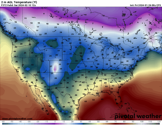
Take a look at the CFS forecasted temperature for January 19th. (-9F)


The cold air looks like it will be in place until 2-7-24. After that, we return to our average temperatures for February. 

On the flip side, those of you in the south, as in southern Texas, Louisiana, Arknasaw, Mississippi, Alabama, Georgia, Florida, South Carolina, North Carolina and Virginia will see severe weather with the possibility of damaging winds and tornadoes between 1-8 and 1-9. 

So how do things look for Bloomington, Indiana? Well, I have my eyes on January 13th. This is NOT a forecast because it could end up being rain or clear skies but look at this! (INTENSE heavy snow *if* it were to happen according to the GFS)


Today through January 19th animation:


The Canadian model has more rain changing-to-snow type systems.


Also, it's interesting to see the European model agree with the GFS model on the January 13th storm.


Here is the latest analysis from the National Weather Service:
National Weather Service Indianapolis IN
313 PM EST Sat Jan 6 2024

.Key Messages...

- Drizzle/patchy fog through the rest of the afternoon.

- A weak system tonight will bring additional light snow with
amounts up to an inch north of Indianapolis.

- Few changes to forecast with storm system Monday night into early
Wednesday; primarily rain and gusty winds expected much of the
event, with a brief burst of light snow accumulations possible at
the onset and ending Monday night and Tuesday night. Impacts to the
Wednesday morning commute possible.

- Yet another strong winter storm is possible in the Midwest late
next week into the weekend. Much too early for details but continue
to watch for possible impacts.

&&

.Short Term...(This evening through Sunday)
Issued at 312 PM EST Sat Jan 6 2024

Rest of Today.

Lingering low clouds and abundant near surface moisture has led to
occasional drizzle with lowered visibilities across central Indiana.
Temperatures at Indianapolis have only varied by 3 degrees between
31 and 34 since midnight and with sunset approaching, not expecting
any more than a 1 degree increase through the rest of the day.  With
surface temperatures just above freezing, there haven`t been any
impacts from the drizzle but will continue to monitor this ahead of
the loss of the minimal daytime sun. ACARs soundings combined with
IR satellite show that the top of the cloud layer lacks ice which is
leading to the drizzle vs snow as seen earlier.

Tonight.

This cloud layer will begin to deepen later into the evening and
overnight hours with ice nucleation expected to begin around 7-8PM
which will coincide with a weak wave that is expected to move across
the northern counties to bring another quick hitting snow. There is
little to no vorticity with this system with snow being driven more
by lift within the 600mb to 850mb layer which is much less
substantial than what was seen during the overnight hours last night.

This snow should generally remain isolated to points along and north
of I-70 with amounts no greater than an inch for most spots with
most areas seeing closer to 0.50". Temperatures tonight will remain
near steady state with lows in the low 30s with westerly winds
beginning to strengthen as pressure gradients briefly tighten across
the forecast area.

Sunday.

Similar weather is expected for tomorrow with some lingering low
clouds in the morning with drier air gradually working in.  Non-zero
instability will arrive by the afternoon with dry adiabatic lapse
rates up to the top of the boundary layer at around 3kft with drier
air above it. This could have led to some brief convective snow
showers/light rain if the top of the cloud layer had been a bit
cooler combined with a weaker cap at the top of the boundary layer,
but with those limitations expect just a few areas of heavier
sprinkles or perhaps light snow mid to late afternoon with much of
the precipitation ending by noon.

&&

.Long Term...(Sunday night through Saturday)
Issued at 312 PM EST Sat Jan 6 2024

Very active long term period across central Indiana, with at least a
couple of impactful systems likely for the region.

The first round of the week comes Monday night into early Wednesday.
A very strong low pressure system will pull quickly northeast out of
the Texas Panhandle into central Illinois and northwest Indiana late
Monday into Tuesday evening. Ensemble guidance is very well
clustered with a low track near or just northwest of the northwest
corner of the forecast area, which will keep central Indiana in the
warm sector and all rain for the bulk of the event.

However, Monday night presents an opportunity for a quick burst of
accumulating snow on the leading edge of the precipitation, despite
borderline near surface temperatures - forecast profiles show a deep
near-isothermal layer near or just below 0C, and with the onset of
strong frontogenetic forcing at the nose of the low level jet Monday
night, dynamic cooling may offset midlevel warm advection for a few
hours either side of midnight and allow for a burst of briefly heavy
snow to accumulate, potentially up to an inch or two, primarily from
Indy northward.

However, strong low and midlevel warm advection as we approach
daybreak Tuesday will rapidly produce a changeover to rain, with
rain continuing through the day on Tuesday. Precipitable water
values continue to exceed climatological 90th percentile much of the
event, with probabilistic guidance showing rainfall amounts in
excess of a half inch a virtual certainty (90%) and in excess of an
inch a significant likelihood (50-60+%), which may put a slight dent
in the longer term drought conditions. Some minimal upright
instability is present in some forecast profiles, and given the
strong dynamics present throughout the depth of the troposphere,
some elevated convection/embedded thunder cannot be ruled out, but
remain uncertain and will not include for now.

As the low continues to wrap up and move rapidly northeast into the
central Great Lakes, onset of cold advection Tuesday night will
promote a potentially rapid changeover back to a mix or all snow,
with potential for another brief burst of accumulations in the
plentiful wraparound moisture before precipitation tapers off late
Tuesday night into Wednesday morning as the column dries from aloft.
Will have to monitor for possible impacts to the Wednesday morning
commute.

Some of the guidance suite produces a weak clipper-type system
moving through the Great Lakes late Thursday into Friday, with
additional potential for light snow or a mix across portions of the
area, particularly north.

Models then show another strong low somewhere in the region Friday
night into Saturday, but extremely large ensemble spread and model-
to-model inconsistencies give very low confidence on precipitation
types and amounts - but another round of impactful precipitation is
on the table.

It remains very important to avoid keying in on one model, one run,
or one cherry-picked extreme solution, particularly for the late
week system, and to instead monitor trends and updates from trusted
sources as the week wears on.
Enjoy and have a great weekend!