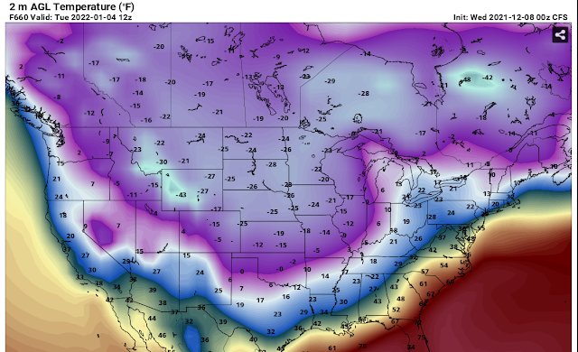
Will we go from record warmth to record cold in one month? Check out this 2M air temperature from the CFS for January 25th. This is a long way off from now so it can't be trusted but it gives you an idea of what one model is thinking.

Will we go from record warmth to record cold in one month? Check out this 2M air temperature from the CFS for January 25th. This is a long way off from now so it can't be trusted but it gives you an idea of what one model is thinking.
Issued at 300 PM EST Tue Dec 28 2021

Thursday Through Thursday Night.

Rain will come to an end across central Indiana late Wednesday night
as the forcing associated with an 850 to 700mb jet exits the area.
Dry weather then briefly returns for Thursday but with the polar air
locked well into Canada, temperatures look to remain well above
average.  Model soundings still show moderate saturation at the mid
levels, so expect at least partly cloudy skies to continue through
the overnight hours before the thicker clouds arrive Friday.

Friday Through Tuesday.

The next rain producing system will move out of the Southern Rockies
and track to the northeast Thursday into early Friday with
precipitation for central Indiana beginning Friday afternoon.
Confidence in the track of the low has increased but there remains
many of the mesoscale features that remain uncertain that will
impact the axis of heaviest rain or the threat for thunderstorms.
Current thoughts are the axis of heaviest precipitation will be
south of the Ohio River with northerly surface flow across much of
the area. This will keep central Indiana out of the warm sector and
keep thunder or strong storm threats to near zero.

If the track inches northward a bit, the southern counties could see
a few thunderstorms. A weak TROWAL may allow for some snow to mix
into the northern counties Saturday into early Sunday after the
initial round of rain, but confidence in both the strength of the
TROWAL and how could the airmass is are both low at this time. High
pressure and seasonable weather then arrives Monday into Tuesday as
high pressure builds across the area.

I respect the National Weather Service. They are professionals. I've met some of them and shook their hands (long before the pandemic). They do excellent work. The information that they provide for free is highly invaluable to those who can't afford the latest model of a smart phone and a subscription to a paid weather app. If you want to purchase a weather app or if you want to sell a weather app subscription service, then fine. But this; this slamming of the National Weather Service is not necessary.

There's evidence that cold air will build into Canada in January. The main questions is, will any of it spill southward into the USA? Perhaps it will stay bottled up in Canada. If it does, that means the warmer weather will continue through January. These kinds of things are hard to predict but take a look at these longe range computers runs by the CFS. Notice the time and date stamp and the -40 degree temperatures in Canada.


More life threatening and damaging tornadoes off to our west tonight. If you have family members in this area, warn them now!

8 feet of snow in California and not Buffalo New York.
https://www.usatoday.com/story/news/nation/2021/12/14/powerful-storm-lashes-california-rain-wind-snow/8895250002/
8 miles of frozen river in Maine has caused an ice jam.
https://weather.com/safety/winter/video/maine-river-clogged-by-miles-long-ice-jam
That describes the weather for the next ten days to two weeks but if you want the real recipe, see below. Nonetheless, everything is on the table including rain, strong storms, wind, fog, snow, high temperatures in the 60's and low temperatures in the 20's. The good news is that the hint of strong storms showing up will not be severe, just noticeable. Real Winter is still on hold until January. The CFS has backed off on the extreme cold but it's still there.
Thursday 11/16/21


1 pound lean ground meat, such as hamburger, elk, or turkey
2 medium or one giant onion, diced
4 cloves garlic, minced
2 cups cooked brown lentils
2 cups cooked black beans
1 small zucchini, quartered and sliced2/3 cup chopped celery (about 2 large celery ribs) 2 cups frozen corn
2 cups kale or spinach
4-6 potatoes, sliced thin
1 cup a blend of uncooked rice (wild rice and long grain white rice work great)1 1/4 cup green beans (chopped, ends removed)4 ounces pancetta or chopped uncured bacon2 cups shredded cabbage
1 medium zucchini, quartered and then sliced
1 quart whole tomatoes, about 4 cups (if you don’t bottle at home, store-bought whole or diced tomatoes work well too)
1 quart broth
1 T. fresh chopped rosemary
1 T. fresh chopped thyme
2-3 T. fresh chopped basil
1/4 cup fresh chopped parsley
1 T. salt
1 tsp. black pepper
In a skillet cook the ground meat, onion, and garlic until the meat is cooked through and no longer pink. Add the meat mixture to a large 6-quart crock pot. Add all of the other ingredient. While you are pouring the tomatoes in, crush them with your hands before they fall into the crock pot. Place the lid on the clock pot and cook for 6-8 hours on low or 4-6 hour on high. If you aren’t a crock-potter just cook the meat in a large stock pot and add everything to when the meat is cooked through. Let it simmer on the stove for 45 minutes to an hour. Add salt and pepper to taste and serve with hot bread.
Notes:
This makes a huge batch of soup. I froze half of it for a second easy meal and then just let it thaw in my fridge overnight when I was ready to use it.
Don’t have all those fresh herbs? Dried will work fine too, just use about half as much dried and then test for taste a few hours into cooking.
This soup is super forgiving. The tomatoes, broth, and herbs are the base but you can swap/add/remove just about anything you like to suit your tastes. It’s a great recipe to start with and make your own.
Yes, unfortunately this is true. It's rare but it can happen and it has happened before. The last time this happened was back in 2015.


Area Forecast Discussion
National Weather Service Indianapolis IN
645 AM EST Fri Dec 10 2021

...Updated Aviation Discussion...

.Short Term...(Today through Saturday)
Issued at 321 AM EST Fri Dec 10 2021

...SEVERE WEATHER RISK late tonight into early Saturday...

Early this morning... Stratus clouds have continued to lift north of
the area, which allowed areas of dense fog to steadily expand in
coverage across much of Illinois into Central/Northern Indiana.
Observations have been fluctuating between near 1/8 of a mile to a
couple miles, but the trend has been steadily down. This will likely
result in a need for an early morning Dense Fog Advisory, which
given the lack of mixing and trapped moisture, any dense fog that
does develop could be slow to erode.

Warm frontal boundary continues to lift north across the region,
which can easily be found where Td`s climb to around 50 degrees.
Which is very anomalous for early Dec.

Focus for the remainder of the day will continue to be on the
impending severe weather, timing/coverage along with expected
hazards. There hasn`t been much change in the forecast approach the
last 24 hours. The one focus that has changed is the coverage of the
slight risk has shifted further north, along with an expansion to
the enhanced risk by the SPC. (spc.noaa.gov/products/outlook/)

Trough axis will continue to deepen, which will lead to further
amplification of the overall wave. Additionally, northern stream cold
pool will create a very sharp baroclinic zone across the Northern
Plains later today. As these two systems progress eastward, the
surface low will continue to deepen as it quickly lifts across the
Missouri Valley towards the Chicago area tonight.

The challenges for late fall/winter systems is generation of typical
large CAPE, or the convective potential energy; however, what does
typically occur in these very dynamical setups is abundant shear
with considerable low-level moisture. Couple this with very robust
llvl jet of 60-70kts in the 850-825mb range, thus the atmosphere
will not need an abundance of CAPE to generate convection. In
addition to the aforementioned elements, which are only a portion of
the atmospheric setup, temperatures are poised to rapidly rise
throughout the day but more so late afternoon and evening. Current
guidance suggests temps will peak late this evening in the mid 60s,
coupled with a moisture rich environment and dewpoints equally in
the upper 50s to lower 60s.

Timing for the convective initiation continues to be focused on the
arrival of a very potent speed-max of 100kt around 500mb. This will
create the trigger, interacting with the moisture rich and extremely
sheared low-levels across the Tennessee Valley/Ohio Valley, and
likely linger well past midnight for the region, before a dry nose
begins to arrive around 6-9Z Sat.

As for the focus on storm mode: At the onset it still appears to be
more cellular; however, guidance continues to indicate steady upward
growth into more linear pieces or also known as QLCSs, carrying a
risk for damaging winds and possibly even an isolated tornado.
Directional shear continues to be more uniform in the lowest 1km;
however, speed shear is potent near 40-50kts. Coupled with shallow
LCLs, and the risk for tornadoes remains present especially in any
linear segments.

Area of greatest concern: With the minor adjustment from the SPC and
inclusion of an enhanced risk, the focus continues to be on the
Western TN/KY area stretching north into Central Indiana.


If you take a look at the radar you see one thing but if you take a look outside of your window you don't see anything. It seems that the air is too dry and the snow is not making it all the way to the ground because it is evaporating.


When the red and green line are touching, it means the atmosphere is saturated. When they are far apart, the atmosphere is dry. The two yellow numbers and lines indicate where snowflakes form way up above our heads. Just as it is forming, the atmosphere dries out right below it, hence, evaporation and no snow.
Wooo hooo! It's not much but it's something given the overall warm pattern and yes, we will be back up to 65 degrees by Friday so enjoy tomorrow night.
Special Weather Statement
National Weather Service Indianapolis IN
254 PM EST Mon Dec 6 2021

INZ021-028>031-035>049-051>057-060>065-067>072-071000-
Carroll-Warren-Tippecanoe-Clinton-Howard-Fountain-Montgomery-
Boone-Tipton-Hamilton-Madison-Delaware-Randolph-Vermillion-Parke-
Putnam-Hendricks-Marion-Hancock-Henry-Vigo-Clay-Owen-Morgan-
Johnson-Shelby-Rush-Sullivan-Greene-Monroe-Brown-Bartholomew-
Decatur-Knox-Daviess-Martin-Lawrence-Jackson-Jennings-
Including the cities of Delphi, Flora, Williamsport,
West Lebanon, Lafayette, West Lafayette, Frankfort, Kokomo,
Attica, Covington, Veedersburg, Crawfordsville, Lebanon,
Zionsville, Tipton, Fishers, Carmel, Noblesville, Anderson,
Muncie, Winchester, Union City, Farmland, Parker City, Clinton,
Fairview Park, Rockville, Montezuma, Rosedale, Greencastle,
Plainfield, Brownsburg, Danville, Indianapolis, Greenfield,
New Castle, Terre Haute, Brazil, Spencer, Gosport, Martinsville,
Mooresville, Greenwood, Franklin, Shelbyville, Rushville,
Sullivan, Carlisle, Shelburn, Farmersburg, Linton, Bloomfield,
Jasonville, Worthington, Bloomington, Nashville, Columbus,
Greensburg, Vincennes, Washington, Loogootee, Shoals, Bedford,
Mitchell, Seymour, and North Vernon
254 PM EST Mon Dec 6 2021

...LIGHT ACCUMULATING SNOW TUESDAY NIGHT...

An upper level disturbance will track across the region Tuesday
night...bringing a period of light snowfall from Tuesday evening
through the predawn hours Wednesday. Snow accumulations will be
light...with most locations seeing a half inch to one inch by
Wednesday morning. A few spots may see slightly higher amounts.

The timing of the snowfall along with it being the first
widespread accumulation of the season will likely produce higher
impacts to travelers early Wednesday...especially during the
morning commute. Be prepared for icy spots on roads...bridges and
overpasses. Untreated roads may be snow covered as well.
Bundle up.

Temperatures will recover slightly into the afternoon before the
drop off resumes into tonight. The presence of strong cold advection
will limit any temp rises from this point this morning to 2-3
degrees at best. Continued gusty westerly winds peaking up near
30mph this afternoon will keep wind chills in the 20s at best.
There's a lot of chatter on Twitter about a snowstorm next week. It's way too early to discuss this so be careful when you see images forecasting large amounts of snow. Here are the images posted on Twitter:


Here is what the National Weather Service is saying:
.Long Term...(Friday through Wednesday)
Issued at 312 PM EST Wed Dec 1 2021

Mild Weather Continues this Weekend....

Westerly WAA over the short term will help build a broad ridge over
the southern CONUS, keeping the polar jet north of central Indiana.
This will allow for a warmer than normal temperatures to continue
through the weekend. Friday will be 10-15 degrees warmer than
average as a weak wave within the low level flow will back surface
winds to the SW, advecting even warmer air into the region. Some mid
level clouds will be possible on Friday given the passage of the
wave, but surface moisture return will be insufficient for any low
level clouds or precipitation to occur. There is some uncertainty on
afternoon highs for Friday given increased cloud cover. Current
expectations are for most locations along and south of I-70 to reach
60 with mid 60s possible in far SW central Indiana.

Near zonal flow aloft and weak low level disturbances will continue
to have marginal impacts on Saturday and Sunday. Low level winds
will shift back towards the NW for Saturday, dropping highs around
10 degrees. Skies will clear on Saturday though within broad
subsidence as the low level ridge axis passes through central
Indiana. By Sunday, the ridge will be east of central Indiana, once
again placing the region in predominant SW flow. Temperatures should
spike back into the mid to upper 50s for Sunday. This SW flow will
also be upstream of a stronger cyclone over the plains.


Precipitation Possible Early next Week...

Weather will become more active early next week, as two more
amplified troughs approach from the NW. The first chance of
precipitation will be late on Sunday into Monday morning.
Significant moisture return within strong SW flow will push Pwat
values above seasonal. This along with broad vertical lift should be
enough for scattered showers to develop. This should be east of the
region by Monday morning, although ensemble members are still varied
on overall timing for this event.

The next wave looks to move through Tuesday into Tuesday night. This
wave should be attached with cold Canadian air and interact with
leftover moisture from the initial wave. This will lead to snow on
the cold side of the system. Where this low will track is still
widely varied, but there is a chance of snow Tuesday night.
Confidence in possible snow amounts are still too low to provide
value to the forecast at this time.
It's 49 degrees with a 12 MPH wind out of the south. It's just a tad bit too cold to go golfing today. I know how the golfers feel. They are not #BOTS fans at all. They feel more like this:

The holiday comes with an 80% chance of rain so take an umbrella to Grandma's house tomorrow. Other than that the pattern we are in is a very quiet one. I don't see anything interesting coming up until December 5 - 10. That's too far away to trust any computer model at this point. I've seen some models give rain, then snow, then ice and then nothing. Check out these wild forecasts of snow in Florida and Georgia.


Also, a word on snow forecasts. Fox 59 out of Indianapolis did a nice weather story on how to spot "Snow Spam". That means how tell when someone is lying about us receiving two feet of snow. It's a good article. Check it out:
What a bummer! We missed out on most of the snow as it is now off to our east in Ohio. Enjoy it while it lasts.


.Short Term...(Today through Sunday)
Issued at 305 AM EST Sat Nov 13 2021

Many locations across central Indiana have seen their first
snowflakes of the season over the last several hours. Early this
morning...pockets of flurries continue to drift across the northeast
half of the forecast area in tandem with an upper trough axis. 08Z
temperatures were in the 30s with continued brisk westerly winds
making it feel even colder.

The warm pleasant weather enjoyed through much of the first ten days
of the month now feel like a distant memory and will feel even
further away as the weekend progresses. The first true winter-like
weekend of the season is upon us with cold gray weather expected
through Sunday with the added potential for a dusting of snow late
tonight into Sunday morning as a surface wave tracks through the
lower Great Lakes.

A deep upper level low was centered over James Bay this morning with
a sharp trough axis currently swinging through the region. This
will be replaced by subtle ridging aloft later today before another
piece of energy on the back side of the upper low pivots across the
upper Midwest and into the Ohio Valley for Sunday. At the surface...
ridging will follow in tandem for later today with the upper ridge
ahead of the aforementioned surface wave dropping out of the
northern Plains late today and across the lower Great Lakes for
Sunday. The combination of these features will be a continued
unsettled weather pattern for much of the weekend.

Scattered flurries continue early this morning but have generally
decreased in coverage as drier air aloft begins to advect into the
region. Despite the drier air expanding with the ridging as the day
progresses...model soundings and RH progs show a stout low level
inversion that will persist all day and into this evening. With
moisture trapped beneath the inversion...a low stratus deck will
remain through this evening and while the moisture remains shallow
with little to no forcing aloft...cannot rule out a few flurries or
sprinkles lingering into the afternoon. Steepening lapse rates
beneath the inversion also support this potential which should
mainly focus over the northern half of the forecast area. Brisk W/SW
winds will continue today as well though not be anywhere near as
gusty as on Friday.

The approach of the surface wave from the northwest later tonight
will bring the first measurable snowfall to much of central Indiana
focused predominantly during the predawn hours through Sunday
morning before warming through the boundary layer gradually
transitions snow back to rain. Nice mid and upper level diffluence
will develop ahead of the approaching surface low and upper trough
late tonight which in tandem with a surge of isentropic lift aided
by strengthening 850mb flow will spread precip into the region from
the west after 05-06Z. Critical thicknesses support the precip type
to be snow for much of the forecast area through daybreak Sunday
with any mixing with rain likely confined to the lower Wabash Valley
where the boundary layer will be slightly warmer. Precip type will
gradually switch to rain through midday Sunday from southwest to
northeast before snow mixes back in late day with renewed cold
advection behind a cold frontal passage.

As mentioned above...confidence continues to grow in seeing the
first measurable snowfall for much of the forecast area early Sunday
with a dusting up to perhaps around an inch with the highest amounts
across northern counties. With road temperatures still quite
warm...expect most accums will be confined to grassy and elevated
surfaces with little to no impacts to travelers. This will likely
melt as temperatures warm on Sunday. Precip will be coming to an end
by sunset Sunday as the low pulls away and high pressure begins to
build in from the west.

Temps...well below normal temperatures are expected through the
weekend. Low level thermals support undercutting guidance with highs
later today likely to struggle to 40 degrees. Sunday will end up
only subtly warmer by a couple degrees. Brisk conditions today with
the potential for higher gusts Sunday will bring a raw chilly feel
to the air. Lows tonight will drop into the upper 20s and lower 30s.

&&

.Long Term...(Sunday Night through Friday)
Issued at 305 AM EST Sat Nov 13 2021

The beginning of the long term period will be dry but chilly after a
trough exits the area and ridging takes its place. Tight pressure
gradients will continue winds gusting to around 25 kts for Sunday
night, but as the axis of the surface high settles in, winds will
drop back down to 5 to 10 kts for the start of the work week.

The airmass origin will change quickly during the first half of
the week from a chilly, westerly airmass to a warm, southerly one.
This shift in the flow comes ahead of another trough, allowing
for strong warm air advection as temperatures Tuesday and
Wednesday are expected to briefly return to the 60s. A surface
cold front associated with the trough will allow lift for the
moisture also being advected into the area. A line of rain showers
is expected to track from NW to SE through the day Wednesday and
possibly into the day Thursday. The exact timing of this system
has yet to be ironed out, but models are trending more towards
Wednesday to Wednesday night than Thursday at this time. There is
agreement on a lack of instability so will keep out any mention of
thunder for now.

Behind the front, a northwesterly airmass will return temperatures
back into the 40s and 30s, with lows possibly dipping into the 20s,
for the remainder of the period. Friday looks dry due to subsidence
passing through, but central Indiana could see additional rain and
mixed precipitation over the weekend.

&&

.Aviation...(12Z TAF Issuance)
Issued at 539 AM EST Sat Nov 13 2021

IMPACTS:
- MVFR ceilings through early evening...then returning towards
daybreak Sunday
- Periodic westerly wind gusts approaching 20kt through early
afternoon
- Snow showers impacting the terminals predawn hours Sunday

DISCUSSION: A few flurries continue to drift across central Indiana
early this morning underneath a thick MVFR stratus deck. As drier
air aloft expands into the region...the flurries should gradually
diminish through the day. However...a stout inversion will keep the
stratus deck over central Indiana all day with only modest
improvement towards sunset. Westerly winds will be in excess of
10kts into the afternoon with periodic gusts to near 20kts before
falling back by late afternoon.

Model soundings show the inversion relaxing this evening which
should enable a return to VFR ceilings into the early overnight.
Clouds will remain though as low pressure approaches from the
northwest. Precipitation will expand across central Indiana after
06Z with low level thermals supporting the precip type as snow.
Could see visibility restrictions within the light snow through
daybreak Sunday with ceilings once again returning to MVFR and
perhaps dropping to IFR or lower Sunday morning. Winds will back to
southerly towards daybreak Sunday.
Let's your friends now if they want an interesting job for the winter.
Today is the 46th anniversary of the sinking of the SS Edmund Fitzgerald. There was a powerful storm on November 9-10, 1975 on Lake Superior. That storm was likely the cause of the sinking of the ship and this incident gave rise to the popular song by Gordon Lightfoot.


https://en.wikipedia.org/wiki/SS_Edmund_Fitzgerald
https://www.youtube.com/watch?v=PH0K6ojmGZA
#BOTS fans! Remember remember the fifteenth of November. There's a small chance for snow showers Sunday night into Monday. I say small because one computer model gives us rain and another one gives us a nice thumping of snow; as in 6 inches. Wednesday 11/10 will be last day to get out and play golf so take advantage of it while you can. Rain moves in Thursday. Read the National Weather Service's discussion below.


.Long Term...(Wednesday night through Monday)
Issued at 300 AM EST Tue Nov 9 2021

Big changes coming up in the long term as a potent negatively tilted
trough and associated strong low pressure system will bring a quick
slug of moderate to heavy rain to the area Thursday followed by much
colder temperatures and periodic isolated to scattered shower
activity for the weekend.

Models consistent in bring a strong cold front across central
Indiana Thursday afternoon. The front will interact with deep
moisture feeding in from the southwest the tune of around 1 inch
precipitable water amounts. This lends high confidence to widespread
rain Thursday. Low level jet at 50 knots and 70 plus knot deep shear
will also be in place, but lack of instability will not favor
updraft growth and subsequent severe weather or even a lightning
mention. Fast speed of the system suggests the rain will move east
of the area early Friday evening and rainfall totals will be at best
an inch and more likely less than an inch. This should not cause any
flooding issues. Strong low pressure gradient will result in gusty
south and southwest winds through Saturday.

Colder air will rush in behind the cold front with afternoon highs
only in the 40s to lower 50s Friday and even colder the rest of the
weekend. The upper trough will bring another chance of showers to
the area Friday afternoon and evening. Critical thicknesses and
Bourgouin Method supports the possibility of a few snowflakes mixing
in with the rain over the northeastern half Friday night.

The next notable system will be a clipper that will bring a good
chance of rain and snow showers to the area Sunday and Sunday night.

Temperature advection and cloud cover considerations support well
below temperatures by Friday with afternoon highs mostly in the 40s
and overnight lows in the upper 20s and lower 30s. Prior to that
warm advection will support well above normal temperatures in the
upper 50s and lower 60s Thursday. A quicker frontal passage then
expected would result in cooler highs in areas where the front
passes through earlier in the day.
The CFS computer model is not well respected or trusted but it does a farily good job of picking up on warming or cooling trends in the long range. Check this out. The freezing line is down in Florida. That's doesn't mean it will be that cold on November 24th but it does *indicate* that a cold punch of air is likely during the second half of November.

Expect even colder temperatures for next week.


Short Term...(Today through Wednesday)
Issued at 255 AM EDT Tue Oct 26 2021

...Patchy Frost Tonight and Possible Fog Through daybreak Wed...

Early This morning:
Satellite imagery showing the trapped stratus layer over the Ohio
valley, with cold-dry air still advecting in from the northwest.
Lake effect clouds are apparent off of Lake Michigan as well with a
strong thermal differential and shallow moisture availability, which
could see as winds turn slightly northerly bending a few lake clouds
south into the northern forecast area prior to daybreak. Otherwise
the pre-dawn hours will be welcomed with some decreasing clouds as
the deeper moisture peels off to the east. Temps prior to daybreak
may dip a few more degrees, but will hinge on clearing and
decoupling the mixed layer to relax the winds. This would then allow
some additional release of heat from the surface and drop temps into
the lower 40s where dewpoints are presently.

Today-Tonight: Mid-lvl heights begin to rise quickly today as an
amplifying ridge quickly pushes east ahead of the next system. This
ridging will continue to scour the moisture in the atmosphere, but
also produce a mostly sunny day. Temps may be slightly sluggish to
warm given the saturated soil conditions across the region,
absorbing much of the radiation from the sun, but still expect temps
to push into the mid to upr 50s. The peak of the ridge slides
overhead later this evening, setting the stage for a quick drop in
temps post-sunset. Expecting considerable radiational cooling to
take place evening/overnight, with minimal wind being mixed down and
a dry profile. This should see a release of heat into the mid/upr
30s across the forecast area by early Wed morning, but could also
see some radiational fog develop. It is conceivable that a few
locations in the far north/northeast or along and east of a
Lafayette to Muncie line falling to around 33-35 degrees or flirting
with freezing conditions. Confidence is low that we will need any
growing season headline; however, some patchy frost is favorable.
The fog may not be as potent as once thought, given there may still
be some wind albeit less than 5 mph, but in the valley and low-lying
areas fog will likely develop in the canopies.

Wednesday: 500mb heights will remain elevated through daybreak Wed,
as the approaching Pacific system has a slightly negative tilt. This
suggests the energy in the lower levels will have pushed east of the
upper level support, which guidance indicates the surface low will
be lifting northerly from the Arklatex region midday wed. Gulf
moisture continues to be primed for being ingested into this system
in the lower levels, which will only further expand the precip
shield later Wed. Still confidence the heights aloft of Central
Indiana will hold, helping to prolong the diffluent flow and delay
precip arrival until later Wed.

With continued minimal cloud cover Wed, expect a large diurnal swing
in temps for much of the area as the surface can realize and absorb
the sunlight and push temps to around 60 by midday. Then flow will
begin to turn southerly with cirrus shield steadily increasing from
south/southwest to north in the afternoon.

&&

.Long Term...(Wednesday night through Monday)
Issued at 255 AM EDT Tue Oct 26 2021

...Wednesday Night into Saturday...

Another good dose of rainfall is expected late in the week as the
powerful Pacific system moves eastward across the country and closes
off by Wednesday morning over the Plains.

The large upper low will slowly push eastward across the Ohio and
Tennessee Valleys Wednesday night into the early portion of the
weekend, with showers possible throughout that time frame, but
particularly Thursday into Friday as forcing and precipitable water
values are maximized. Models are generally in good agreement that
precipitable water values will be high but not massively so,
generally a bit above the climatological 75th percentile or a bit
below 2 standard deviations for the time of year...or as high as
about 1.1 to 1.3 inches.

Total precipitation during the latter half of the week looks to be
about 0.75 inch to 1.5 inches, which should not significantly worsen
the current hydrologic situation, in part thanks to the prolonged
time frame of the rainfall. This will, however, prolong the elevated
streamflows and any return to baseline hydrologic conditions.

...Saturday Night into Monday...

The latter half of the weekend should be dry as a narrow axis of
upper level ridging and surface high pressure move into the area.

...Monday Night into Tuesday...

A solid cold front looks to move through the region early next week,
which may produce some additional showers as cyclonic upper level
flow drops into the Midwest. A good cooldown should accompany this
front with overnight lows by the end of the forecast period dropping
well into the 30s. Model handling of this front and the potential
for surface low development along it differ far more substantially
than with the earlier system and result in fairly low pops for now.