From the Associated Press:
https://www.hoosiertimes.com/herald_times_online/news/state/weather-service-confirms-tornadoes-hit-indiana-on-monday/article_dc0bc190-be15-554c-8a09-0093e39f3f8c.html
Memorial Day Tornadoes in Indiana
I think we were all surprised to hear about the tornadoes in northern Indiana last night. As of right now, there was definitely a tornado in Pendleton, Indiana. There were a total of 16 reports of tornadoes in northern Indiana last night with six of them being confirmed. That equals the average for the entire month of May so hopefully we will be done for a while.
The stubborn stalled frontal boundary still exists over northern Indiana and it will try to move southwards by mid-week. We could experience severe weather between Wednesday night and Thursday evening.
On the bright side, it cools down a little or the weekend with high temperatures in the upper 70's by Sunday and Monday.
If you are new to this blog and have just moved to Indiana as a new student or a new resident, please spend the extra money to get an all-hazards emergency weather radio. It could save your life.
We get lucky for once.
It looks like the entire state of Indiana will miss out on tornadoes this week. There's a small chance for thunderstorms Wednesday into Thursday. We could see a high of 90 by Friday.
School closings for tornadoes.
I've not heard of this before but its a great idea.

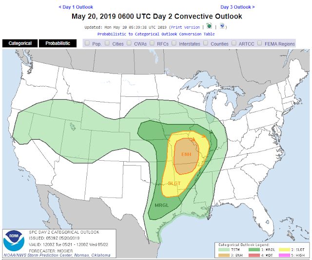

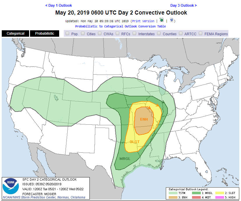
Tornado risks for Monday through Wednesday:


Severe Storm Watch until 10pm.
Clouds continue to stream from south to north. Sure, it looks beautiful now but storms are firing up to our west.


Predicting the unpredictable.
@12:30pm the radar doesn't look as bad as yesterday's forecast showed but I still urge caution. It's a tricky setup because there are two boundary layers (see images below) rather than one. There's the cold front out west. Then there's a layer of cooler air and then a layer of warmer air and then a layer of cooler air and then a final layer of warmer air. Yesterday's forecast showed one solid line or boundary layer between the warm air and cold air which usually means severe storms. Today though...mmm... not so much. It will be interesting to see how this all plays out.


Strong storms possible on Sunday, May 19th.
There's a good chance for strong storms tomorrow. I don't think it would be a good idea to go to Bryan Park for a picnic tomorrow just in case any organization in town happens to be thinking about it.


Discussion from the NWS:


Discussion from the NWS:
.SHORT TERM /Tonight through Monday Night/...
Issued at 346 AM EDT Sat May 18 2019

Forecast challenges focus on a stormy Sunday with a severe weather
threat for the afternoon and early evening.

The upper low kicking out of the northern Rockies will sharpen
tonight with a new piece of energy developing over the central
Plains this evening. This will prompt a new surface low organizing
over the Missouri Valley this evening then tracking northeast into
the Great Lakes Sunday as the upper low lifts into the Upper
Midwest. The upper trough will take on a negative tilt as it lifts
through the area Sunday afternoon and combined with a cold front set
to track through the area late day...pronounced threat for severe
convection is in play for central Indiana.

Convection that develops out over the central Plains late today
into the evening will shift east and should arrive into the Wabash
Valley during the predawn hours Sunday morning in a weaker state.
Showers and storms will track east across the forecast area
through early afternoon aided by a strengthening 50-60kt low level
jet that will advect an axis of much deeper moisture into the
Ohio Valley and should maintain a higher coverage of rain and
storms over the region. Outside of showers and storms...the strong
low level jet will ensure potential for gusts to peak near 40 mph
Sunday afternoon.

Morning convection should largely shift east of central Indiana by
mid afternoon with a narrow dry slot between the departing
convection and the approaching cold front. This dry slot will be key
in developing a short window of just a few hours focused on the late
afternoon and early evening where the atmosphere will become
supportive of robust convective development along and immediately
ahead of the front. The NAMNest and the WRF models all suggest
redeveloping convection that should organize into a line or a couple
of smaller lines as it tracks east through the forecast area. With
modest instability and an axis of higher BL shear and helicity ahead
of the front along with continued strong low level winds and
diffluent flow aloft...growing support for late day storms to carry
all modes of severe weather with the main threat of damaging winds.
Large hail will be a secondary concern as wet bulb zero levels drop
into the favorable 8-9kft level. Does appear enough directional
shear will be present for rotating storms as well.

Storms will shift east with the cold front Sunday evening...with
cooler and drier air arriving with high pressure late Sunday night
into Monday. Expect a breezy start Monday with winds gradually
slackening through the day as the high builds into the Ohio Valley.
Will be some diurnal cu development on Monday with cold advection in
the wake of the frontal passage...but expect plenty of sunshine as
well. Northwest winds Monday will veer to north/northeast Monday
night as the high passes through the Great Lakes.

Temps...Leaned much closer to the warmer MAV guidance Sunday but
more clouds and a greater threat for rain will keep much of the area
in the 70s. Cooler MET guidance is preferred for MOnday as low level
thermals support highs generally in the 60s. After a muggy night
tonight in the 60s...lows will fall back as low as the mid and upper
40s by Monday night.
39 - 86!
What a difference four days can make. Forecast temperatures for the weekend are starting climb a bit. Here are some forecast highs from different sites for our area for Friday and Saturday.
Weather.com 83 / 85
Accuweather 86 / 86
Wx Underground 86 /84
NWS 86 / 86
Dark Sky 85 / 85
It's hard to believe that we reached 39 degrees early Tuesday morning.


Weather.com 83 / 85
Accuweather 86 / 86
Wx Underground 86 /84
NWS 86 / 86
Dark Sky 85 / 85
It's hard to believe that we reached 39 degrees early Tuesday morning.


Ooh la la.
A nice week ahead. We warm up for the weekend with high temperatures near 85 by Saturday.
How low will it go?
A high of 82 degrees today and then a big cool down. Thursday through Wednesday will feature high temperatures in the 60's and low temperatures in the 40's. Friday night's low could get down to 41 degrees.
From the NWS:
From the NWS:
.SHORT TERM /Tonight through Friday Night/...

Issued at 144 AM EDT Wed May 8 2019

Active weather appears in storm tonight and Thursday.

The GFS and NAM suggest a strong short wave pushing toward Indiana
within the quick SW flow aloft. Best forcing looks to arrive after
06Z. Meanwhile at the surface Low pressure surges northwest of
Indiana and the associated LLJ develops across Indiana ahead of
the low...reaching a moderate 40+ knots. Meanwhile within the mid
levels favorable moisture appears present and Time sections and
forecast sounding all show deep saturation by 12Z. Thus will trend
toward categorical pops late tonight and early on thursday as
these features pass. Forecast soundings show limited instability
and although a rumble of thunder will still be
possible...widespread thunderstorms arent expect late tonight or
on early thursday. Bad diurnal timing will also plague instability
development.

Frontal passage is suggested to occur Thursday evening...but the
bulk of any moisture and forcing will be well ahead of the surface
front...and any heating ahead of the front should be limited by
the rain expected during the day. Aloft...the GFS and NAM suggest
a weaker short wave to pass overnight while lingering and limited
lower level moisture remain near the front. We will need to keep
some small chances on Thursday night and early friday as these
features pass...however with limited moisture at this point any
precip amounts will be small.

By Friday afternoon and Evening forecast soundings dry out
considerably as strong high pressure builds across Indiana. As
For temps will trend warmer on Wednesday night with expected
precip and cooler on Thursday through Friday with expected
rainfall and cold air advection as high pressure builds across the
region.

&&

.LONG TERM /Saturday through Tuesday/...

Issued at 329 AM EDT Wed May 8 2019

An upper wave approaching on Saturday will bring in some chances
for showers to the southern counties by Saturday afternoon as a
surface front remains between the Ohio and Tennessee valleys.
Stronger upper forcing will move in Saturday night and bring rain
chances across the area, but lack of instability should mean
showers and not thunderstorms. Chances will hang around most of
the area through Sunday morning as the surface system is slow to
move out, but by Sunday afternoon surface high pressure should
start building in and bring rain to an end. Small chances for
showers could move back in on Tuesday from the north if the
surface high gets shoved southward. Temperatures should be below
normal through much of the long term with upper troughing
transitioning to northwesterly upper flow. Near normal
temperatures could return for Tuesday.


Subscribe to:
Posts (Atom)