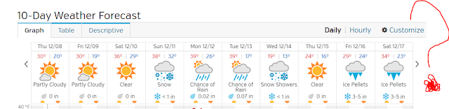
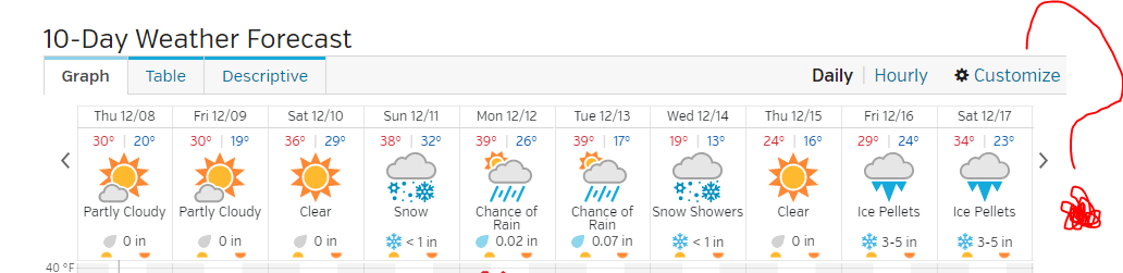
Today is Thursday, December 29, 2017. Temperatures will be slightly warmer than normal until January 4, 2017. What is mean by slightly warmer? Well, our normal average temperatures for this time of year are 37 for the high and 21 for the low. The forecast temperatures for Thursday, January 5, 2017 (or one week from today) are 28 for the high and 13 for the low. I think we will continue to see this warm front-to-cold front set up where we get rain changing to snow. That has been the dominant patter for Indiana. I don't see anything major on the horizon yet.
We'll see a high of 39 degrees today and a low of 26 degrees.
Warm and rainy for Christmas.
Temperatures begin moderating today and by late week we will see high temperatures near 50 degrees. Several rain storms look to pass through our area. A cold shot returns on January 4, 2017.
Thunder Sleet?
I heard a loud rumble of thunder last night around 9:00pm but I just couldn't believe it. How could that be possible? So, I dismissed it as a car wreck near by. Then I found these by Bam and Tds out of Indianapolis.


@8:30pm Saturday 12/17
The NWS made a pretty good call on issuing alerts. The temperature drop and the approaching line of ice and snow seemed like it would arrive before 7:00pm. The original Winter Weather Advisory alert was for 7:00PM 12/17 to 7:00AM 12/18. The start time was then moved to 9:00PM 12/17. I noticed the ice just beginning to stick on my car and the sidewalk around 8:30PM. The current temperature in Bloomington is 31.5 degrees. If we are lucky, the ground temperature is lagging behind due to today's earlier warm spell which put us above freezing.
@3:38PM Saturday 12/17
The current temperature is 36 degrees. There's no way we will see temperatures above 50 degrees as foretasted earlier. The new high is for 41 degrees which is far more reasonable. Check out this advisory map. It has everything from snow, to ice, to rain, to thunderstorm and even tornadoes.


12/17 @9:00AM
The current air temperature is 34 degrees. Temperatures may be closer to freezing at the ground. Be careful. The sidewalks around town and on Kirkwood have ice on them.
Temperatures will warm up today to about 50 degrees. After that the wintry mix returns tonight. Due to that, the NWS has placed Monroe county and surrounding counties under a winter weather advisory from 7:00PM Saturday 12/17 to 7:00AM Sunday 12/18. If you have anything to do today, try and get it done before 7:00PM.
Temperatures will warm up today to about 50 degrees. After that the wintry mix returns tonight. Due to that, the NWS has placed Monroe county and surrounding counties under a winter weather advisory from 7:00PM Saturday 12/17 to 7:00AM Sunday 12/18. If you have anything to do today, try and get it done before 7:00PM.
The pattern looks the same for the rest of the month.
1. Several rain-to-snow-like systems passing through or near the Ohio valley.
2. Storms bring brief warm up before they arrive and a quick cool down after they leave.
3. Snow accumulations pretty much on the lighter side.
4. Before storms arrive, overrunning warm air over cold air has the potential to produce icing.
5. Temperature will continue to bounce around.
2. Storms bring brief warm up before they arrive and a quick cool down after they leave.
3. Snow accumulations pretty much on the lighter side.
4. Before storms arrive, overrunning warm air over cold air has the potential to produce icing.
5. Temperature will continue to bounce around.
What the weekend storm means for the Bloomington area.
Saturday's high temperature will be in the lower 50's. Can you believe it after this morning's low of 5 above? During Saturday night between 9pm and 11pm the rain will switch over to sleet and snow. It all depends on how fast the front arrives. The earlier it arrives, the more concern I have about us seeing a "Flash Freeze". A flash freeze means that the rain water on the ground freezes very quickly; not instantly but within a few hours. So, if you are out driving around between 12am and 2am, you should be very careful.
The skies clear out on Sunday and Sunday night we go down into the single digits again. The good news is that next week the temperatures will be closer to normal; highs in the mid to upper 30's with lows in the 20's.
The skies clear out on Sunday and Sunday night we go down into the single digits again. The good news is that next week the temperatures will be closer to normal; highs in the mid to upper 30's with lows in the 20's.
Weekend weather for December 17 & 18.
This event is looking a lot like the event of last weekend with a few exceptions. Keep in mind that this storm is more than three days away so a lot could change. The way I see it, we get a light snow or mix set up early Saturday morning changing to all rain. As the low tracks off to the north east, another low tries to develop and fails but is just strong enough to give us some wrap-around snow showers.


It's snowing in Bloomington Indiana.
It's our first snow of the Winter 2016-17 season! There won't be much, perhaps an inch and then it's all over by noon. Our average first snowfall is between December 15th and 17th so we are a little ahead of schedule.


Forecast for Sunday 12/11/16 is back to rain again.
I hope people get it now. Don't trust the models so far into the future.
Be extra careful using weather apps on smart phones and tablets.
I'm sure everyone has their favorite weather app installed on their device. Remember that forecasts become less reliable when looking more that three days into the future. So, check this out! This is what I found on my Weather Underground App; 6 - 10 inches of ice on 12/16 & 12/17. HA!
The cold front is on its way!
@4:40pm in Bloomington it was 36 degrees with overcast conditions. A cold front will move through and temperatures will plummet. Thursday night's low will be 19 degrees and Friday night's low will be 18. There's no snow in the forecast until Sunday 12/11.
The current radar shows snow right over us but it's not reaching the ground.

I don't think we will see any snow tonight. A lot of people got this call wrong, even some of the big guys.

It's Wednesday and people are already talking about a snowstorm on Sunday. Just yesterday the forecast was for a rain/snow mix changing to rain and changing back to snow. Today it is all snow. What will it be tomorrow?
Do we get warmer after December 15th?
Temps trend slightly above normal for the days after December 15th.


Case in point!
In the last days of November people were excited about a snow storm developing between the 8-10th December. Now it seems to have vanished. This is why you don't put so much faith in models 7 to 10 days out.


The NWS does give us a 30% chance of snow Wednesday night.


The NWS does give us a 30% chance of snow Wednesday night.
Warning on snowmageddon pictures.
It's that time of year again when pictures of winter storms that are two weeks away appear show snow accumulations of 30+ inches. Do not fall for these as they are being circulated on social media. These are operational computer models that spit out one like that and then in the next 6 to 12 hours the same model will say sunny and warm with a chance of thunderstorms. Please take these pictures with a grain of salt. 24 to 48 hours before the event is to arrive is when you have the best forecast information.
There does appear to be something showing up in the models for the central Indiana area for December 8th - 10th but that's about all anyone can say. Actually, ensembles seem to be trending slightly warmer with a more zonal flow towards the middle of December.
There does appear to be something showing up in the models for the central Indiana area for December 8th - 10th but that's about all anyone can say. Actually, ensembles seem to be trending slightly warmer with a more zonal flow towards the middle of December.
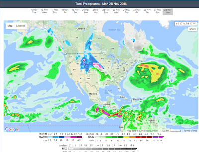
Showers and storms possible on Monday 11/28.
Monday should be a rainy and windy day. The area inside the red circle should watch out for wind damage.


A high of 74 today and 71 tomorrow.
Enjoy it while it lasts folks. This coming weekend is going to feel much colder with temperatures dipping into the mid 20 for Saturday night.
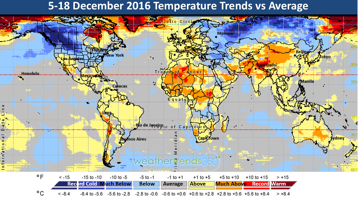
Below I've attached my "very general", "non-specific" winter analysis. It looks like we are going to have a weak La Nina in play. I think we will see shots of warm air followed by cold air followed by warm air and then cold air again (see Rossby Waves below). The light blue represents where the persistent cold will be. The orange represent the pacific jet stream transporting the warm air and the red represents the likely storm track. If the pacific jet and the storm track and the cold front happen to line up just right say over Kentucky, then we get snow. If not we get a lot of rain.
 If you are a #BOTS! fan then this is probably not such great news. Snow lovers would like a scenario more like this:

Below I've attached my "very general", "non-specific" winter analysis. It looks like we are going to have a weak La Nina in play. I think we will see shots of warm air followed by cold air followed by warm air and then cold air again (see Rossby Waves below). The light blue represents where the persistent cold will be. The orange represent the pacific jet stream transporting the warm air and the red represents the likely storm track. If the pacific jet and the storm track and the cold front happen to line up just right say over Kentucky, then we get snow. If not we get a lot of rain.


NWS says no snow for the Bloomington IN area this weekend.
Snow chances increase from 20% upwards from a line north and east of Crawfordsville, to Indianapolis to Greensburg.


Sunday, November 27 low temperature of 25 degrees in Bloomington, Indiana
Get ready for the hard freeze! Overall though, the trend has been slightly warmer than average.

The trend line below definitely captures what it has felt like so far.

An interesting setup for Monday, November 28th.

The trend line below definitely captures what it has felt like so far.

An interesting setup for Monday, November 28th.

A special weather statement has been issued for North Dakota
SPECIAL WEATHER STATEMENT
NATIONAL WEATHER SERVICE BISMARCK ND
239 PM CST MON NOV 14 2016

NDZ001>005-009>013-017>023-025-031>037-040>048-050-051-150445-
DIVIDE-BURKE-RENVILLE-BOTTINEAU-ROLETTE-WILLIAMS-MOUNTRAIL-WARD-
MCHENRY-PIERCE-MCKENZIE-DUNN-MERCER-OLIVER-MCLEAN-SHERIDAN-WELLS-
FOSTER-GOLDEN VALLEY-BILLINGS-STARK-MORTON-BURLEIGH-KIDDER-
STUTSMAN-SLOPE-HETTINGER-GRANT-BOWMAN-ADAMS-SIOUX-EMMONS-LOGAN-
LA MOURE-MCINTOSH-DICKEY-
INCLUDING THE CITIES OF...CROSBY...BOWBELLS...POWERS LAKE...
LIGNITE...COLUMBUS...PORTAL...MOHALL...GLENBURN...SHERWOOD...
BOTTINEAU...ROLLA...DUNSEITH...ROLETTE...SHELL VALLEY...
ST. JOHN...WILLISTON...NEW TOWN...STANLEY...PARSHALL...MINOT...
VELVA...TOWNER...DRAKE...RUGBY...WATFORD CITY...KILLDEER...
HALLIDAY...BEULAH...HAZEN...CENTER...GARRISON...WASHBURN...
UNDERWOOD...WILTON...TURTLE LAKE...MCCLUSKY...GOODRICH...HARVEY...
FESSENDEN...CARRINGTON...BEACH...MEDORA...DICKINSON...MANDAN...
BISMARCK...STEELE...TAPPEN...JAMESTOWN...MARMARTH...MOTT...
NEW ENGLAND...ELGIN...CARSON...NEW LEIPZIG...BOWMAN...HETTINGER...
FORT YATES...SELFRIDGE...SOLEN...LINTON...STRASBURG...NAPOLEON...
GACKLE...LAMOURE...EDGELEY...KULM...WISHEK...ASHLEY...OAKES...
ELLENDALE
239 PM CST MON NOV 14 2016 /139 PM MST MON NOV 14 2016/

...WIND...COLD AND HEAVY SNOW ARE POSSIBLE LATE THIS WEEK...

MUCH COLDER TEMPERATURES AND WIND CHILLS IN THE TEENS AND SINGLE
DIGITS ARE POSSIBLE LATE THIS WEEK AND INTO THE WEEKEND. HEAVY
SNOW AND GUSTY NORTH WINDS ARE POSSIBLE THURSDAY EVENING THROUGH
FRIDAY. CONSIDERABLE UNCERTAINTY REMAINS IN THE EXACT
TRACK...SPEED...AND STRENGTH OF THE STORM SYSTEM.
HOWEVER...IMPACTS TO TRAVEL AND COMMERCE ARE POSSIBLE OVER PARTS
OF THE REGION. TAKE TIME NOW TO PREPARE FOR THE POSSIBILITY OF
SIGNIFICANT WINTER WEATHER. BE SURE TO MONITOR THE LATEST FORECAST
FOR UPDATES.

What's happening next week?

After that, a strong storm develops over North Dakota and heads north eastwards into Canada.

Once the storm exits, it drags some colder air in behind it.


Strong pacific air to keep things a little warm for a while.
It looks like the cold air has moved into Russia while the warm air from the pacific and southeast Asia are being funneled into North America. There will still be intervals of cold shots but the pattern is looking warmer than normal for now.


Winter is just around the corner!
I apologize for being away so long. Nonetheless I'm back and winter will be back soon too. Currently in Bloomington, Indiana it is 60 degrees. It has been unusually warmer than normal for this area but that is about to change. On Saturday November 12 the low temperature is forecast to be near freezing. The National Weather Service says 33 degrees. Weather Underground says 32 degrees and AccuWeather says 29 degrees. Either way, this will mean an end to the growing season.
Beyond that, all eyes turn to November 18 - 20 and the week of Thanksgiving. Storms systems have been popping up and disappearing on the models for both weeks. I think the Thanksgiving storm is the one worth keeping an eye on but remember, these are weeks away and a lot can change by then.
As of now my first impressions are that November and December are slightly above normal in temperatures while January will be below normal. We'll see how it all plays out.


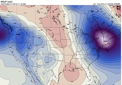
A 965 Low right on the edge of the coast line?
It's officially fall!
Some quick highlights:
Summer like temperatures through the rest of the week and into weekend.
Nice cool down on Thursday, September 29.
Another cool down on Sunday October 2.
Snow is showing up in the forecast for the mountains of Utah north of Salt Lake City.
http://forecast.weather.gov/MapClick.php?map.x=204&map.y=101&minlon=-115.5&maxlon=-108.5&minlat=36.96&maxlat=42.68&mapwidth=354&site=slc&zmx=1&zmy=1
8/24/16 Why the tornadoes happened.
First off, the tornado watch expires in about ten minutes or at 9:00pm. Whew, good for us right? I'm still concerned about the dewpoint being at 74 but hey, what do I know. If the National Weather Service says it's over then it's over.
So why did this happen? There was an upper level low /disturbance centered over north west Indiana. During the day time heating hours, the ULLD began churning a wave of energy nearly due east. This was helped and fueled by a high pressure blocking system to our southeast (over North and South Carolina) and a low pressure system over the northern tip of Texas. In addition to that, a cold front was attached to that low extending north eastwards. If you could imagine it, here is how I saw the weather unfolding for the day:


So, to recap, the purple fuchsia "L" represents my placement of the upper level disturbance. The black triangle represents the basic air flow and pattern for our area. The yellow is the west to east storm flow that NWS plotted correctly.

8/24/16 Tornado Watch for Monroe County Indiana Unitl 9:00pm tonight.
Whoa! This caught me off guard. I have been busy as of late. The current temperature in Bloomington is 85 degrees and the dewpoint is 73. We are only under a tornado watch for now. To our north, a tornado has been confirmed near the Kokomo area. Stay tuned in and stay safe.


Also keep an eye our for tropical low #99 to have an impact on Florida and the gulf coast a week from today.


Also keep an eye our for tropical low #99 to have an impact on Florida and the gulf coast a week from today.


Subscribe to:
Posts (Atom)