URGENT - WEATHER MESSAGE
National Weather Service Northern Indiana
328 PM EDT Wed Jun 27 2018

INZ003>009-012>018-020-022>027-032>034-MIZ077>081-OHZ001-002-004-
005-015-016-024-025-280330-
/O.NEW.KIWX.EH.A.0001.180629T1600Z-180701T0000Z/
La Porte-St. Joseph IN-Elkhart-Lagrange-Steuben-Noble-De Kalb-
Starke-Pulaski-Marshall-Fulton IN-Kosciusko-Whitley-Allen IN-
White-Cass IN-Miami-Wabash-Huntington-Wells-Adams-Grant-Blackford-
Jay-Berrien-Cass MI-St. Joseph MI-Branch-Hillsdale-Williams-
Fulton OH-Defiance-Henry-Paulding-Putnam-Van Wert-Allen OH-
Including the cities of Michigan City, La Porte, South Bend,
Mishawaka, New Carlisle, Walkerton, Elkhart, Goshen, Nappanee,
Lagrange, Topeka, Shipshewana, Angola, Fremont, Kendallville,
Ligonier, Albion, Auburn, Garrett, Knox, North Judson, Bass Lake,
Winamac, Francesville, Medaryville, Plymouth, Bremen, Culver,
Rochester, Akron, Warsaw, Winona Lake, Syracuse, Mentone,
Columbia City, Tri-Lakes, South Whitley, Fort Wayne, New Haven,
Monticello, Monon, Brookston, Logansport, Royal Center, Peru,
Grissom AFB, Mexico, Wabash, North Manchester, Huntington,
Roanoke, Bluffton, Ossian, Decatur, Berne, Marion, Gas City,
Upland, Hartford City, Montpelier, Portland, Dunkirk, Niles,
Benton Harbor, St. Joseph, Fair Plain, Benton Heights, Buchanan,
Paw Paw Lake, Dowagiac, Cassopolis, Marcellus, Sturgis,
Three Rivers, White Pigeon, Mendon, Coldwater, Bronson,
Hillsdale, Jonesville, Litchfield, Bryan, Edgerton, Wauseon,
Archbold, Swanton, Delta, Defiance, Sherwood, Hicksville,
Napoleon, Deshler, Liberty Center, Paulding, Antwerp, Payne,
Ottawa, Leipsic, Columbus Grove, Continental, Pandora, Van Wert,
Ohio City, Lima, and Spencerville
328 PM EDT Wed Jun 27 2018 /228 PM CDT Wed Jun 27 2018/

...EXCESSIVE HEAT WATCH IN EFFECT FROM FRIDAY AFTERNOON THROUGH
SATURDAY EVENING...

The National Weather Service in Northern Indiana has issued an
Excessive Heat Watch...which is in effect from Friday afternoon
through Saturday evening.

HAZARDOUS WEATHER...

 * Temperatures are expected to rise into the lower to mid 90s
   Friday and Saturday with heat indices from around 100 to near
   110.

 IMPACTS...

 * The combination of hot temperatures and high humidity will
   likely lead to an increased risk of heat related stress and
   illness. The very young, the elderly, those without air
   conditioning, and those participating in strenuous outdoor
   activities will be the most susceptible.

  * Car interiors can reach lethal temperatures in a matter of
    minutes.


PRECAUTIONARY/PREPAREDNESS ACTIONS...

An Excessive Heat Watch means that a prolonged period of hot
temperatures is expected. The combination of hot temperatures and
high humidity will combine to create a dangerous situation in
which heat illnesses are possible. Drink plenty of fluids...stay
in an air-conditioned room...stay out of the sun...and check up
on relatives and neighbors.
Excessive Heat Watch posted for northern Indiana.
The first week of summer and the great beyond.
The 90+ degree heat will return on Thursday. The next best chance of rain is from Tuesday night into Wednesday morning.
There's a good news / bad news story with the long range data. The monthly outlooks show that July temperatures will be above normal. That doesn't mean every day but it means on average for the the month of July. The August data shows temperatures to be below normal. That's the good news.
We just have to figure out how to survive the next 5 weeks before we see some sustained relief.
(Ps: Long range data is always subject to change and thus is not very reliable but it serves as good guidance).
I wish I could catch one of these on camera.
Special Weather Statement
Special Weather Statement
INZ021-028>031-035>049-051>057-060>065-067>072-230100-
Carroll-Warren-Tippecanoe-Clinton-Howard-Fountain-Montgomery-
Boone-Tipton-Hamilton-Madison-Delaware-Randolph-Vermillion-Parke-
Putnam-Hendricks-Marion-Hancock-Henry-Vigo-Clay-Owen-Morgan-
Johnson-Shelby-Rush-Sullivan-Greene-Monroe-Brown-Bartholomew-
Decatur-Knox-Daviess-Martin-Lawrence-Jackson-Jennings-

Special Weather Statement
National Weather Service Indianapolis IN
456 PM EDT Fri Jun 22 2018

...COLD AIR FUNNELS POSSIBLE TODAY...

Generally funnel clouds and tornadoes develop and occur in
conjunction with conditions that produce severe thunderstorms.

There are weak showers and thunderstorms in the area, but little
potential for actual tornadoes with only weak wind shear.

Research studies of funnel cloud occurrences indicate that a
different type of funnel cloud forms when weather conditions are
similar to those of today. these are called cold air funnels and
are not as violent as those associated with severe thunderstorms.

Cold air funnels are associated with thunderstorms or showers
that form in deep...cold core...large-scale low pressure systems
such as the one overhead today. These funnel clouds are smooth
and narrow. The parent storm or shower is not particularly tall or
intense. These funnel clouds normally protrude a few hundred feet
downward from the parent clouds...rotate or spin like a top...and
last only a few minutes before dissipating.

In rare cases when their circulations does reach the ground...
cold air funnels cause only minor damage. More reports of small
funnel clouds are possible over Central Indiana today. Warnings
may be issued if any of them touch the ground for an extended
period of time.
Slow moving rain system still churning away
The back western edge of this weather system extends through Illinois to St. Louis.
That means more chances for rain tonight and tomorrow morning. Clear skies on Sunday and Monday with high temperatures in the low to mid 80's. After that the heat returns. We'll be at or above 90 degrees by next Thursday.
Check out these great storm cloud pictures from yesterday's 8:00pm storm.


That means more chances for rain tonight and tomorrow morning. Clear skies on Sunday and Monday with high temperatures in the low to mid 80's. After that the heat returns. We'll be at or above 90 degrees by next Thursday.
Check out these great storm cloud pictures from yesterday's 8:00pm storm.


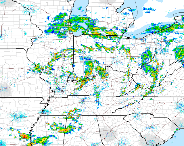
Storms tonight and tomorrow.
The low pressure system over north east Missouri will slowly move towards Indiana by Saturday. The main threat will be strong storms tonight and tomorrow.

That middle band over central Illinois looks like it could produce a tornado or two before sunset.

That middle band over central Illinois looks like it could produce a tornado or two before sunset.
More on the way.
There are two more blobs on the radar to our west so I would expect more rain later this evening. I don't think there will be anything severe though but always pay attention.


Small pop storm right over northern Monroe County.
It's so small that is bisects Bloomington in half from east to west. I wouldn't be surprised to hear stories at work tomorrow about how people in the northern part of the county saw rain, lightening and high winds while people in the southern part of the county saw some clouds and then sunshine.


A heat advisory has been issued for Monroe County.
Heat Advisory
URGENT - WEATHER MESSAGE
National Weather Service Indianapolis IN
958 AM EDT Mon Jun 18 2018

...HEAT ADVISORY IN EFFECT FROM NOON TO 8 PM EDT TODAY...

INZ021-028>031-035>049-051>057-060>065-067>072-182200-
/O.CON.KIND.HT.Y.0001.180618T1600Z-180619T0000Z/
Carroll-Warren-Tippecanoe-Clinton-Howard-Fountain-Montgomery-
Boone-Tipton-Hamilton-Madison-Delaware-Randolph-Vermillion-Parke-
Putnam-Hendricks-Marion-Hancock-Henry-Vigo-Clay-Owen-Morgan-
Johnson-Shelby-Rush-Sullivan-Greene-Monroe-Brown-Bartholomew-
Decatur-Knox-Daviess-Martin-Lawrence-Jackson-Jennings-
Including the cities of Lafayette, Frankfort, Kokomo,
Crawfordsville, Anderson, Muncie, Indianapolis, Terre Haute,
Shelbyville, Bloomington, Columbus, Vincennes, Bedford,
and Seymour
958 AM EDT Mon Jun 18 2018

...HEAT ADVISORY REMAINS IN EFFECT UNTIL 8 PM EDT THIS EVENING...

* TEMPERATURE...Afternoon temperatures in the lower to middle
  90s, with maximum afternoon heat index values around 105
  degrees.

* IMPACTS...The heat will lead to hazardous conditions
  particularly for the elderly, those with preexisting health
  conditions, and pets. Heat exhaustion or heat stroke is
  possible.

PRECAUTIONARY/PREPAREDNESS ACTIONS...

Take extra precautions, if you work or spend time outside. When
possible, reschedule strenuous activities to early morning or
evening. Know the signs and symptoms of heat exhaustion and heat
stroke. Wear light weight and loose fitting clothing when
possible and drink plenty of water.
A hot one today and a hot one tomorrow.
Yep! It was hot a humid today and I loved it. The high temperature was 93 degrees. It will also be 93 degrees tomorrow. We start to cool off a little bit by Wednesday and a little more by Thursday. Rain chances will also increase by mid-week.
FYI: The hottest parts of the day time are between 1:00pm and 5:00pm, with 3:00pm being the hottest part of the day. I hope that helps for tomorrow.
I enjoyed today. I went to Bryan Park and sat underneath a tree and read and took pictures. It was great to see others out enjoying themselves too.


FYI: The hottest parts of the day time are between 1:00pm and 5:00pm, with 3:00pm being the hottest part of the day. I hope that helps for tomorrow.
I enjoyed today. I went to Bryan Park and sat underneath a tree and read and took pictures. It was great to see others out enjoying themselves too.


Air Quality Alert issued for Bloomington and Monroe County
If you suffer from allergies or have asthma or other breathing related health issues this may be important information for you.
Air Quality Alert
Air Quality Alert Message
National Weather Service Indianapolis IN
600 PM EDT Thu Jun 14 2018

INZ037-039>041-046-048-054>056-061>064-067-068-071-152300-
Boone-Hamilton-Madison-Delaware-Hendricks-Hancock-Morgan-Johnson-
Shelby-Greene-Monroe-Brown-Bartholomew-Knox-Daviess-Jackson-
Including the cities of Anderson, Muncie, Shelbyville,
Bloomington, Columbus, Vincennes, and Seymour
600 PM EDT Thu Jun 14 2018

...AN OZONE ACTION DAY HAS BEEN DECLARED...

The officials at the Indiana Department of Environmental
Management have called for an Ozone Action Day on Friday...June
15 for the following Indiana counties...

Boone, Hamilton, Madison, Delaware, Hendricks, Hancock, Morgan,
Johnson, Shelby, Greene, Monroe, Brown, Bartholomew, Knox,
Daviess, and Jackson

An Ozone Action Day means that a combination of the high
temperatures, light winds, and other factors, are expected to
produce conditions where high levels of ozone emissions may exceed
federally mandated standards.

Here are some recommended actions that the public can take to reduce
ozone forming emissions:

     * Walk, bike, carpool or use public transportation.
     * Avoid using the drive-through and combine errands into one trip.
     * Avoid refueling your vehicle or using gasoline-powered lawn
       equipment until after 7pm.
     * Turn off your engine when idling for more than 30 seconds.
     * Conserve energy by turning off lights or setting the air
       conditioner to 75 degrees or above.
June 14, 2018: Thoughts and analysis.
Some computer models are trying to give Bloomington some rain at about 5:00am Friday morning. Maybe it's possible but I just don't see it in the current surface analysis. There's a decent sized high pressure sitting right over Indiana. Check this out:

I think the HRRR model has is exactly right on. Storms go right up to the Illinois-Indiana boarder and this dissipate because they run into the high pressure block.

It will be very hot the next four days: Friday, Saturday, Sunday and Monday. By very hot I mean temperature at 90+ for daytime highs. On Sunday the high will be 94. Be sure to drink plenty of water water and not so much craft beer. Remember that alcohol acts as a dehydrant.
What about "The Taste"?
The Taste of Bloomington is from 3:00pm - 11:00pm Saturday, June 23, 2018. Usually it's been scorching hot or at least it was at the last three of these but the latest long range data suggest that June 21-23 might be slightly cooler than years past. I think we'll see high temperatures in the low to mid 80's on June 23rd. If you want to know the cause of the cooler TOB this year check out this ridiculously amplified pattern. Western Canada is extremely hot in this time frame. (I drew a pink line to show the pattern flow).

Enjoy and be safe.
A line of storms possible for today.
A line of storms has formed in north central Indiana and is moving south-eastwards. I'm guessing that we will see a small pop-storm around 4:30pm.


The next 10 days.
The official start to summer is ten days away or on Thursday, June 21. It looks like we'll see a good chance of rain for today through Wednesday and then it dries off a bit. The rain will be in the form of pop-up storms. These are usually brief heavy downpours with thunder and lightening followed by sunshine and then it repeats again. Temperatures look to hold steady in the mid to upper 80's and maybe a 90 degree day in there too.
Old school forecasting with old school math.
High level forecasting requires use of differential equations which I don't remember how to do anymore. I was without internet service yesterday when I heard the weather radio go off after 5pm. Using the information given on the radio I used pen and paper to note observations and track the storm's timing.


It's snowing...
In the Beartooth Mountains of Montana.
Winter Weather Advisory
URGENT - WINTER WEATHER MESSAGE
National Weather Service Billings MT
852 AM MDT Mon Jun 11 2018

MTZ067-120600-
/O.CON.KBYZ.WW.Y.0030.000000T0000Z-180612T0600Z/
Absaroka/Beartooth Mountains-
852 AM MDT Mon Jun 11 2018

...WINTER WEATHER ADVISORY REMAINS IN EFFECT UNTIL MIDNIGHT MDT
TONIGHT...

* WHAT...Periods of snow. Total snow accumulations of 2 to 4
  inches.

* WHERE...Beartooth Highway over the Beartooth Mountains.

* WHEN...Until midnight MDT tonight.

* ADDITIONAL DETAILS...Plan on slick and possibly snowpacked road
  conditions over the Beartooth Highway, with reduced
  visibilities in periods of heavier snow.
Small update for June 2, 2018 @ 10:30pm
I just wanted to mention that I am on vacation will not be updating my blog for a while because I will be out of town. In the mean time storms are firing up just due west of Bloomington. I think there's a good chance we will see a small thunderstorm tonight and then it cools off a little bit for the rest of the week. High temperatures in the upper 70's to low 80's and some low temperature in the upper 50's. That should be a welcome relief plus the fact that tree pollen should be coming to an end. Welp, enjoy until I see you next week. Here is the current radar image that suggest rain might be on the way.


Strong winds and heavy rain.
Take a look at the three trees in the background leaning towards the left.


Swan wings pictures from yesterday's thunderstorm.
When there's a heavy rain such as the one we had yesterday you will often see cars drive through flooded intersections so fast that they end up creating a large splash of water in the shape of swan wings. Here are some examples:


Today will be about the same a yesterday.
The NWS gives Bloomington a 30-40% chance of seeing a thunderstorm this evening. Be prepared for the possibility of a pop-up thunderstorm just like yesterday's storm. A line is already firing up in Illinois and move east.


Subscribe to:
Posts (Atom)