Ice ice baby!

It's too far away to know any details at this point. Check back on Monday, January 30.
Then you know you are a disgusting racist! This weather event will affect multiple people throughout the state. It is the job of the National Weather Service to alert the public of potentially dangerous weather conditions. That is their mission! I'm too ticked off to blog any more for the next 48 hours. See you on the flip side and be safe and follow the advice of the professionals at the National Weather Service!!!

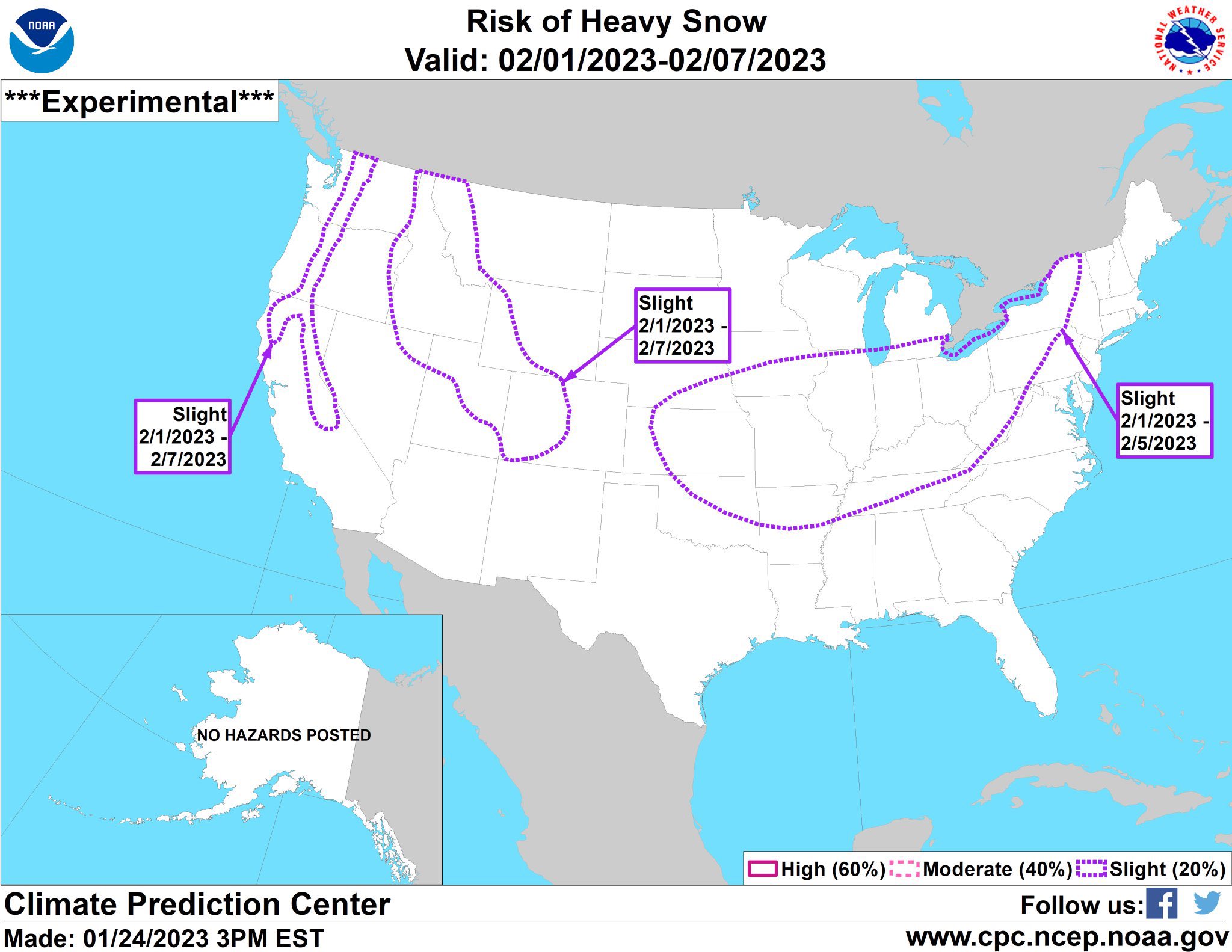
The snow maps for tomorrow can be trusted but the ones for next Wednesday can't be trusted. Do not trust any snow maps on twitter for next Wednesday's snow event. Snow maps will be accurate on Monday morning and perhaps Sunday night, but not right now.

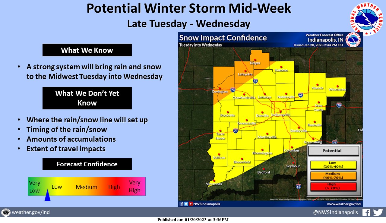
Area Forecast Discussion
National Weather Service Indianapolis IN
218 PM EST Fri Jan 20 2023

.Short Term...(This evening through Saturday)
Issued at 217 PM EST Fri Jan 20 2023

- Mostly Cloudy and Cold Tonight
- Partly cloudy Saturday Morning, increasing clouds during the
  afternoon

Surface analysis early this afternoon shows deep low pressure
exiting out to the Atlantic east of New England.  An associated
trough axis extended west across Lake Ontario to southern WI. Broad,
cold but poorly organized high pressure found across the Great
Plains. The result of these two systems was continued cyclonic flow
across Indiana and the Ohio Valley. GOES16 showed extensive lower
level clouds in place across Central Indiana, the Ohio Valley and
points upstream within the flow. Radar shows a few areas of flurries
pushing across Central Indiana within the cyclonic northwest flow. A
moderate pressure gradient was noted across the area within this
broad cyclonic flow resulting in some gusty winds.

Tonight...

Weak ridging aloft is suggested to build across Indiana and the
Great Lakes late tonight before becoming a bit more predominant on
Saturday. Subsidence is noted within the mid and upper levels as the
ridge builds across the area tonight, as drying is seen within the
forecast soundings and time heights but a different story resides
within the lower levels. The ongoing cyclonic lower level flow is
expected to become more just northwesterly as the deep surface low
continues to depart east. However, ridging within the lower levels
fails to arrive until after 12Z Saturday. Given the extensive cloud
cover as seen on GOES16, we are not confident for much clearing.
Time heights keep saturation within the lower levels overnight while
forecast soundings try to dry the lower levels out overnight. Thus
given the abundance of clouds and the lack of strong clearing
signal, we will keep skies mostly cloudy tonight. Given the expected
cloud cover, will trend lows to low to middle 20s.

Saturday...

The models on Saturday show ridging building aloft over Indiana
before exiting to the eastern Great Lakes by late afternoon.
Meanwhile a broad trough over the plains is expected to begin to
approach Central Indiana by late in the afternoon. Meanwhile at the
surface, high pressure is expected to be moving through the Ohio
Valley. Forecast soundings show a dry column across the area for the
day. Thus some morning clouds could be lingering from the overnight
period, but as heating and mixing resumes through the morning, we
should see some clearing. High clouds will then be expected to
return late in the afternoon as the previously mentioned approaching
trough should begin to advance toward Indiana. Isentropic surfaces
show best lift arriving late in the day over Illinois, but some of
the cloud cover should begin to advance as the day progresses. Thus
increasing cloud cover as the afternoon progresses. Any
precipitation will hold off until the Saturday night period as that
is when better forcing will arrive and time will once again be
needed to saturate the dry column. Given the warm air advection
ongoing and some sunshine expected highs near 40 will be reasonable.

&&

.Long Term...(Saturday night through Friday)
Issued at 217 PM EST Fri Jan 20 2023

Long Term

*Light Snow Accumulations Late Saturday Night/Early Sunday
*Potential Impactful Winter System Mid-Week Next Week

Saturday Night and Sunday.

An active weather pattern will be in place for much of the long
term period with two major weather systems impacting central
Indiana.  The first system will arrive Saturday night into Sunday as
a broad and gradually deepening trough exits the Four Corners region
and pushes into the Central Plains.  Gulf moisture will only
penetrate as far as Tennessee which will limit the available moisture
across central Indiana.

There looks to be 2 areas of heavier snow accumulation with the main
area of surface convergence in the southeast and a secondary area
associated with the more robust cold air to the northwest.  Where
those two line up remains uncertain so will keep the snow
accumulations fairly broad brushed at 0.5" to 1.0" with the thought
that there will likely be an axis of 2-3 inches somewhere across
Indiana.

Monday and Tuesday.

There may be a few residual snow showers Monday if the system ends
up being slower, but think that most of Monday and Tuesday will be
dry with a gradually warming trend as surface flow returns to the
south.

Wednesday Through Friday.

The second and more impactful system of the week then looks to
arrive Wednesday into Thursday as a rapidly deepening upper level
trough and associated surface low pushes into the Southern Plains
and tracks to the northeast.  Model ensembles generally have a solid
handle on the track with the operational GFS on the northern edge of
the ensemble mean.  There are likely to be some sections of the
forecast area that see mostly rain and some that are mostly snow,
but where that sets up remains very uncertain.

One thing to note with these systems is that a typical pattern for
these negatively tilted systems is for the surface low to follow the
track of the 500mb low more closely when deepening.  This more
closely matches the current GFS run while the Euro has it further
southeast which is more typical if deepening is not occurring.

With all that in mind, an impactful winter system looks likely
across portions of the upper Wabash Valley with the main uncertainty
being the rain/snow line and how intense the snow bands will set up
northwest of the surface low.  The system has very strong dynamics
and abundant moisture to allow for significant snow amounts, but
there are a couple of factors that will limit snow accumulations.
The first will be the warm air on Tuesday and Wednesday which will
warm the ground and help melt the initial snow.  Warm air aloft will
also keep the snow out of the dendritic growth zone and push snow
ratios closer to 8:1.

All this gets factored in well by the model guidance which is
showing an axis of 6-10 inches of snow accumulations, but a snow
depth of only 3-5 inches.  Will have to continue to monitor the
model trends, but lean more towards the lower amounts for now,
especially with the uncertainty as to P-type.  The primary impacts
look to be during the daytime hours Wednesday, but confidence in
timing is still somewhat low. The typical post frontal
flurries/light snow may then continue Thursday into Friday.

&&

.Aviation...(18Z TAF Issuance)
Issued at 126 PM EST Fri Jan 20 2023

Impacts:

* MVFR Cigs expected today and early this evening.

Discussion:

GOES16 shows extensive cloudiness across the forecast area with
widespread MVFR Cigs. broad cyclonic flow is expected to remain
across the area today. Tonight the cyclonic flow appears to weaken,
however there is a lack of a strong anti-cyclonic signal or
clearing ridge axis. Thus confidence is low for clearing of cloud
cover. Forecast soundings and time heights show a saturated area
within the lower levels through much of the forecast period. Thus
will keep MVFR Cigs this afternoon and evening and return to low VFR
Cigs tonight as the cyclonic flow weakens while lower level moisture
remains.
There are two syndicated articles from the New York Times called,
Can We Talk About How We Talk About the Weather?
and...
Bomb Cyclone? Or Just Windy with a Chance of Hyperbole? When the barometer drops, the volume of ‘hyped words’ rises, and many meteorologists aren’t happy about it.
It's a great read in my opinion. I think that a lot of conspiracy theories about vaccines exist because most people are lacking in science education and when they don't understand what's being said to them, they fill in the blank with whatever they think it means or whatever they hear from others who also lack a basic science education. Just my two cents,.
______________________________
DENVER — Last week, days after a bomb cyclone (coupled with a series of atmospheric rivers, some of the Pineapple Express variety) took devastating aim at California, a downtown conference center here was inundated by the forces responsible — not for the pounding rain and wind but for the forecast.
Scores of the world’s most authoritative meteorologists and weather scientists gathered to share the latest research at the 103rd meeting of the American Meteorological Society. The subject line of an email to participants on the first day projected optimism — “Daily Forecast: A Flood of Scientific Knowledge.”
But there were troubling undercurrents. Scientists are in consensus on the increasing frequency of extreme weather events — the blizzard in Buffalo, flooding in Montecito, Calif., prolonged drought in East Africa — and their worrisome impacts. At the Denver meeting, however, there was another growing worry: how people talk about the weather.
The widespread use of colorful terms like “bomb cyclone” and “atmospheric river,” along with the proliferating categories, colors and names of storms and weather patterns, has struck meteorologists as a mixed blessing: good for public safety and climate-change awareness but potentially so amplified that it leaves the public numb to or unsure of the actual risk. The new vocabulary, devised in many cases by the weather-science community, threatens to spin out of control.
“The language evolved to get people’s attention,” said Cindy Bruyere, director of the Capacity Center for Climate and Weather Extremes at the National Center for Atmospheric Research. She sat with two fellow scientists at a coffee bar between sessions and became increasingly animated as she discussed what she called “buzz words” that lack meaning.
“I have zero pictures in my head when I hear the term ‘bomb cyclone,’” she said. “We need significantly clearer language, not hyped words.”
Others find that the words, while evocative, are sometimes used incorrectly. “The worst is ‘polar vortex,’” said Andrea Lopez Lang, an atmospheric scientist at the State University of New York in Albany, as she stood in a corridor between weather-science sessions. Dr. Lopez Lang is an expert in polar vortices, which technically are stratospheric phenomena that occur at least six miles above sea level. “But in the last decade, people are starting to describe it as cold air on the ground level,” she said.
Cindy Bruyere, of the National Center for Atmospheric Research, speaks while seated at a table in a coffee shop. A tablemate’s laptop is open in the foreground.
“We need significantly clearer language, not hyped words,” said Cindy Bruyere, director of the Capacity Center for Climate and Weather Extremes at the National Center for Atmospheric Research.Credit...Stephen Speranza for The New York Times
A conference attendee sits looking at a phone. On the wall behind them are three large photographs -- of the open sky, of a raging wildfire, and of a wild river in the sunshine.
In an effort to contain the runaway verbiage, weather scientists have begun to study the impact of extreme-weather language. How do people react to the way the weather is communicated? Do they take the proper precautions? Or do they tune it out?
It’s “a hot topic,” said Gina Eosco, a social scientist with the Weather Program Office at the National Oceanic and Atmospheric Administration. “Literally, communication is our No. 1 concern.” In 2021, Dr. Eosco was an author of a paper with the less-than-pithy title, “Is a Consistent Message Achievable?: Defining ‘Message Consistency’ for Weather Enterprise Researchers and Practitioners.”
For the moment, the answer to the paper’s question is: cloudy. To underscore the issue, Dr. Eosco — sitting on the floor in one conference hall — pulled out her phone and showed a collection of messages from various television stations and websites that used competing graphics, colors and language to characterize the tropical storm Henri, in 2021. The presentations were not terribly distinct from one another, Dr. Eosco noted, but they hinted at the diversity in approaches to branding intense weather.
To fully understand the impact of how people talk about weather, Dr. Eosco said, more information is needed. Her division of NOAA has put out calls for researchers to quantify the effectiveness of weather-messaging strategies, including “visual, verbal messages, naming, categories.”
The broader aim, she said, was to make sure that the official cascade of weather terminology promoted understanding and an appropriate response from the public, not confusion.
“I got a text from a family member this weekend that said, ‘Is an atmospheric river a real thing?’” said Castle Williams, a social scientist sitting on the floor beside Dr. Eosco; the two were joint authors on the 2021 paper about consistent weather messaging. “She thought it was a made-up word for intense rainful.” He added, “I gave her a lot of information about atmospheric rivers.” Dr. Eosco noted that researchers were exploring whether to group atmospheric rivers into categories, much as hurricanes were ranked numerically according to severity.
Some of the vivid terminology begins with the scientists — “bomb cyclone,” for instance. “The reason we called it a bomb is because it is the explosive intensification of a surface cyclone, in other words, the winds you are experiencing near the ground where people live,” said John Gyakum, a meteorologist at McGill University who helped coin the term in the 1980s. The less-pithy definition is “a 24-hour period in which the central pressure falls by at least 24 millibars,” which is a measure of atmospheric pressure.
In the term’s early days, the weather pattern “was primarily an ocean phenomenon,” Dr. Gyakum said, and it still largely is. Perhaps more people are affected these days because the coasts are more densely populated. “Why do we hear more about bomb cyclones than we did 40 years ago?” he said. “People are paying more attention to extreme weather than in the olden days.” He added, “Talking about bomb cyclones is not necessarily an indication of increased frequency.”
According to Google Trends, the phrase “bomb cyclone” was barely uttered until 2017 but has since has risen to a din, along with “weather bomb” and “weather cyclone bomb.”
Some meteorologists said they had become cautious about what they uttered, to avoid sensationalism. “Once you use a term and let the cat out of the bag, you can’t get it back in,” said Andrew Hoell, a research meteorologist with NOAA, where he is co-leader of the drought task force. “It can be used in ways you never imagined.”
He had just finished speaking at the “Explaining Extreme Events Press Conference,” which was fairly dry, linguistically. Afterward, Dr. Hoell was more emphatic about what he won’t say: “I don’t use ‘megadrought.’” Nevertheless, later in the conference he was scheduled to participate in a town-hall discussion titled, “Drought, Megadrought, or a Permanent Change? A Shifting Paradigm for Drought in the Western United States.”
“You will not hear me use that term,” Dr. Hoell said again. “It’s not relevant. I can characterize it in more plain language.”
Such as? “Prolonged drought,” he said.
In the end, the linguistic dilemma reflects a larger challenge. On one hand, scientists say, it is hard to overstate the profound risk that global warming poses to Earth’s inhabitants in the next century and beyond. But the drumbeat of language may not be appropriate for the day-to-day nature of many weather events.
Blame is typically cast in the passive voice: Weather scientists crafted attention-grabbing terms, which were drawn into the ratings-driven media vortex. Daniel Swain, a climate scientist at the University of California, Los Angeles, said that the technical terminology was widely used without context by traditional news media and on social media “where some people might use a term half-jokingly and others are genuinely freaking out.”
He added, “Headlines literally sound like the end of the world.”
Consider the “ARkStorm.” The term emerged in 2010 in a project spearheaded by the United States Geological Survey, which explored a “megastorm scenario originally projected as a 1-in-1,000-year-event.” The term is a verbal mass combining “atmospheric river,” “k” (representing 1,000) and “storm,” with an overall biblical resonance.
“The acronym exists, as one might expect, as a tongue-in-cheek reference to the Noachian flood, though the scenario frankly isn’t that far off from the biblical depiction,” said Dr. Swain, who was among the researchers involved in a 2018 report called ARkStorm 2.0.
The ARkStorm research proposes weather that could flood thousands of miles, cause hundreds of billions of dollars’ worth in damage, prompt the evacuation of more than a million people and happen more frequently than every 1,000 years, particularly on the West Coast. (The Original Forecast, according to Genesis, called for “floodwaters on the earth to destroy all life under the heavens, every creature that has the breath of life in it. Everything on earth will perish.”)
However epic, epochal or apocalyptic, there was no ARkStorm underway in mid-January, despite the email to Dr. Swain from a media outlet inquiring if the ARkSTorm “is going to hit California tonight.”
He quickly called back, to keep misinformation from spreading, Dr. Swain said. He surmised that the outlet had read about the report or read its headline, but had not read the report itself. “No,” he said he told the outlet, “this is not literally the end of the world.”
Remember last Thursday, January 11th when we had thunderstorms and then snow? Well, guess what? That is going to happen again tomorrow on Thursday, January 19th.

The last week of January and the first week of February look interesting. Until then...

Highs in the 50's, fog, rain, thunderstorms and then snow. That's Indiana for ya!


If you do a Google search for the coldest temperature on earth right now you'll find that there is some extremely cold air in the arctic circle and in Russia. You can also use these sites to find the lates coldest temperatures recorded.
https://www.ventusky.com/?p=39;112;1&l=temperature-2m
https://www.eldoradoweather.com/climate/world-extremes/world-temp-rainfall-extremes.php


Long Term...(Thursday through Tuesday)
Issued at 307 AM EST Wed Jan 4 2023

- Slightly Above Normal temperatures

- Chance of Rain and Snow Thursday

- Wintry Mix This Weekend

Thursday...

An upper low will move from just east of Davenport to the
Indiana/Michigan border Thursday. Impulses and a 100+ knot 250
millibar jet streak around the base of the low, frontogentical
forcing and deep moisture from 10-15K feet strongly support PoPs
higher than the meager blend output. So raised PoPs to 30-40% near
and north of a Greensburg to Clinton line with 20% PoPs extending
slightly further south and areas from near Sullivan to Seymour dry.
Would also not be surprised if PoP increase even further in the next
couple of forecasts but for now matching up nicely with neighboring
offices. Low level thicknesses and soundings support a mix of rain,
freezing rain and snow to start Thursday morning and then transition
to mostly rain except areas northwest of Indianapolis, where
afternoon high temperatures are only expected to be a few
degrees above freezing and snow could still mix in.

Thursday night and Friday...

Broad area of surface high pressure will result in subsidence and
combined with drier air moving in aloft on the back side of the
departing upper low will grace central Indiana with dry weather
Thursday night and Friday. However, moist boundary layer will
prevent much clearing until Friday when some breaks will move in
from southwest to northeast. Low level thermals and cloud
considerations support temperatures to climb to normal or slightly
above normal in the middle 30s to lower 40s by Friday afternoon.

Friday night through Sunday...

The next system to impact central Indiana will be a bit tricky with
the thermal setup supporting a transition zone across central
Indiana starting early Saturday.

295K isentropic lift will kick in ahead of a Plains/Missouri Valley
low pressure system starting overnight Friday night and continuing
through early Saturday as the surface low moves across anywhere from
south central to north central Indiana, depending on the model of
choice. This path uncertainty will lead to low confidence in PoPs
and precip type. Current blend would bring a chance of
rain/snow/freezing rain in early Saturday with best chances
southwest, where the precip should be mostly rain and lower chances
northeast, where the precip type should be mostly snow. A jet streak
in the 125+ knot subtropical jet will induce a circulation that will
increase upward vertical motion to the north of the jet in the exit
region. Meanwhile, frontogenesis to the north of the jet will aid in
the northward sloping circulation which could lead to banding at
times. The precip will likely change to rain most areas Saturday
afternoon as warm advection continues with potentially areas north
central areas returning to a mix Saturday night. With the polar air
bottled up well north, look for temperatures to be slightly above
normal with highs in the upper 30s to middle 40s Saturday. Continued
warm advection ahead of the surface low may allow temperatures to
reach the 40s over all sections Sunday as the precip dies down and
ends from west to east.

Sunday night into Tuesday...

Would not rule out more showers Tuesday as another low pressure
system gets close, otherwise high pressure and a drier column could
bring some breaks to the clouds to the area along with continued
slightly above normal temperatures.

&&
Did you enjoy the thunderstorms last night? It looks like temperatures are going to waffle back and forth between 30 and 50 degrees between now and January 21st. After that, it looks like the polar vortex will try and visit us again. Stay tuned.
The rain is ten minutes away so stay in if you can. Southern Indiana could see some localized flooding. Don't be surprised to hear a rumble of thunder or two.
Winter tries to make a comeback on Thursday but it will only last until Saturday.


