As usual, twitter is on fire with extreme snow totals for Indiana. Do not trust these:

On the other hand, you can most certainly trust the National Weather Service's Twitter feed which has this:
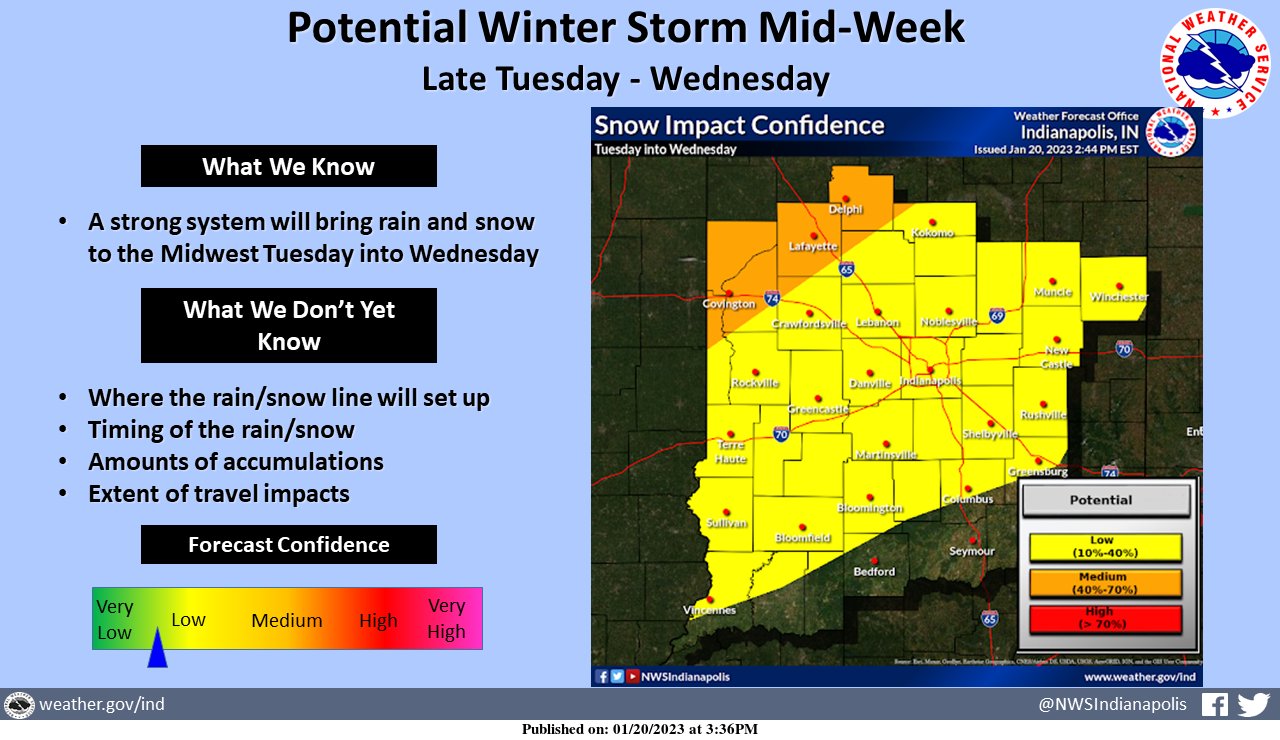
As you can see, there is a disagreement here. The National Weather Service has the far northwestern part of Indiana highlighted for the best chances of impact.
If you are interested in the nitty-gritty details from the National Weather Service, you can read them here:
Area Forecast Discussion
National Weather Service Indianapolis IN
218 PM EST Fri Jan 20 2023

.Short Term...(This evening through Saturday)
Issued at 217 PM EST Fri Jan 20 2023

- Mostly Cloudy and Cold Tonight
- Partly cloudy Saturday Morning, increasing clouds during the
  afternoon

Surface analysis early this afternoon shows deep low pressure
exiting out to the Atlantic east of New England.  An associated
trough axis extended west across Lake Ontario to southern WI. Broad,
cold but poorly organized high pressure found across the Great
Plains. The result of these two systems was continued cyclonic flow
across Indiana and the Ohio Valley. GOES16 showed extensive lower
level clouds in place across Central Indiana, the Ohio Valley and
points upstream within the flow. Radar shows a few areas of flurries
pushing across Central Indiana within the cyclonic northwest flow. A
moderate pressure gradient was noted across the area within this
broad cyclonic flow resulting in some gusty winds.

Tonight...

Weak ridging aloft is suggested to build across Indiana and the
Great Lakes late tonight before becoming a bit more predominant on
Saturday. Subsidence is noted within the mid and upper levels as the
ridge builds across the area tonight, as drying is seen within the
forecast soundings and time heights but a different story resides
within the lower levels. The ongoing cyclonic lower level flow is
expected to become more just northwesterly as the deep surface low
continues to depart east. However, ridging within the lower levels
fails to arrive until after 12Z Saturday. Given the extensive cloud
cover as seen on GOES16, we are not confident for much clearing.
Time heights keep saturation within the lower levels overnight while
forecast soundings try to dry the lower levels out overnight. Thus
given the abundance of clouds and the lack of strong clearing
signal, we will keep skies mostly cloudy tonight. Given the expected
cloud cover, will trend lows to low to middle 20s.

Saturday...

The models on Saturday show ridging building aloft over Indiana
before exiting to the eastern Great Lakes by late afternoon.
Meanwhile a broad trough over the plains is expected to begin to
approach Central Indiana by late in the afternoon. Meanwhile at the
surface, high pressure is expected to be moving through the Ohio
Valley. Forecast soundings show a dry column across the area for the
day. Thus some morning clouds could be lingering from the overnight
period, but as heating and mixing resumes through the morning, we
should see some clearing. High clouds will then be expected to
return late in the afternoon as the previously mentioned approaching
trough should begin to advance toward Indiana. Isentropic surfaces
show best lift arriving late in the day over Illinois, but some of
the cloud cover should begin to advance as the day progresses. Thus
increasing cloud cover as the afternoon progresses. Any
precipitation will hold off until the Saturday night period as that
is when better forcing will arrive and time will once again be
needed to saturate the dry column. Given the warm air advection
ongoing and some sunshine expected highs near 40 will be reasonable.

&&

.Long Term...(Saturday night through Friday)
Issued at 217 PM EST Fri Jan 20 2023

Long Term

*Light Snow Accumulations Late Saturday Night/Early Sunday
*Potential Impactful Winter System Mid-Week Next Week

Saturday Night and Sunday.

An active weather pattern will be in place for much of the long
term period with two major weather systems impacting central
Indiana.  The first system will arrive Saturday night into Sunday as
a broad and gradually deepening trough exits the Four Corners region
and pushes into the Central Plains.  Gulf moisture will only
penetrate as far as Tennessee which will limit the available moisture
across central Indiana.

There looks to be 2 areas of heavier snow accumulation with the main
area of surface convergence in the southeast and a secondary area
associated with the more robust cold air to the northwest.  Where
those two line up remains uncertain so will keep the snow
accumulations fairly broad brushed at 0.5" to 1.0" with the thought
that there will likely be an axis of 2-3 inches somewhere across
Indiana.

Monday and Tuesday.

There may be a few residual snow showers Monday if the system ends
up being slower, but think that most of Monday and Tuesday will be
dry with a gradually warming trend as surface flow returns to the
south.

Wednesday Through Friday.

The second and more impactful system of the week then looks to
arrive Wednesday into Thursday as a rapidly deepening upper level
trough and associated surface low pushes into the Southern Plains
and tracks to the northeast.  Model ensembles generally have a solid
handle on the track with the operational GFS on the northern edge of
the ensemble mean.  There are likely to be some sections of the
forecast area that see mostly rain and some that are mostly snow,
but where that sets up remains very uncertain.

One thing to note with these systems is that a typical pattern for
these negatively tilted systems is for the surface low to follow the
track of the 500mb low more closely when deepening.  This more
closely matches the current GFS run while the Euro has it further
southeast which is more typical if deepening is not occurring.

With all that in mind, an impactful winter system looks likely
across portions of the upper Wabash Valley with the main uncertainty
being the rain/snow line and how intense the snow bands will set up
northwest of the surface low.  The system has very strong dynamics
and abundant moisture to allow for significant snow amounts, but
there are a couple of factors that will limit snow accumulations.
The first will be the warm air on Tuesday and Wednesday which will
warm the ground and help melt the initial snow.  Warm air aloft will
also keep the snow out of the dendritic growth zone and push snow
ratios closer to 8:1.

All this gets factored in well by the model guidance which is
showing an axis of 6-10 inches of snow accumulations, but a snow
depth of only 3-5 inches.  Will have to continue to monitor the
model trends, but lean more towards the lower amounts for now,
especially with the uncertainty as to P-type.  The primary impacts
look to be during the daytime hours Wednesday, but confidence in
timing is still somewhat low. The typical post frontal
flurries/light snow may then continue Thursday into Friday.

&&

.Aviation...(18Z TAF Issuance)
Issued at 126 PM EST Fri Jan 20 2023

Impacts:

* MVFR Cigs expected today and early this evening.

Discussion:

GOES16 shows extensive cloudiness across the forecast area with
widespread MVFR Cigs. broad cyclonic flow is expected to remain
across the area today. Tonight the cyclonic flow appears to weaken,
however there is a lack of a strong anti-cyclonic signal or
clearing ridge axis. Thus confidence is low for clearing of cloud
cover. Forecast soundings and time heights show a saturated area
within the lower levels through much of the forecast period. Thus
will keep MVFR Cigs this afternoon and evening and return to low VFR
Cigs tonight as the cyclonic flow weakens while lower level moisture
remains.
No comments:
Post a Comment