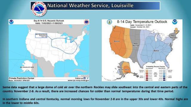
Expect even colder temperatures for next week.
Short Term...(Today through Wednesday)
Issued at 255 AM EDT Tue Oct 26 2021

...Patchy Frost Tonight and Possible Fog Through daybreak Wed...

Early This morning:
Satellite imagery showing the trapped stratus layer over the Ohio
valley, with cold-dry air still advecting in from the northwest.
Lake effect clouds are apparent off of Lake Michigan as well with a
strong thermal differential and shallow moisture availability, which
could see as winds turn slightly northerly bending a few lake clouds
south into the northern forecast area prior to daybreak. Otherwise
the pre-dawn hours will be welcomed with some decreasing clouds as
the deeper moisture peels off to the east. Temps prior to daybreak
may dip a few more degrees, but will hinge on clearing and
decoupling the mixed layer to relax the winds. This would then allow
some additional release of heat from the surface and drop temps into
the lower 40s where dewpoints are presently.

Today-Tonight: Mid-lvl heights begin to rise quickly today as an
amplifying ridge quickly pushes east ahead of the next system. This
ridging will continue to scour the moisture in the atmosphere, but
also produce a mostly sunny day. Temps may be slightly sluggish to
warm given the saturated soil conditions across the region,
absorbing much of the radiation from the sun, but still expect temps
to push into the mid to upr 50s. The peak of the ridge slides
overhead later this evening, setting the stage for a quick drop in
temps post-sunset. Expecting considerable radiational cooling to
take place evening/overnight, with minimal wind being mixed down and
a dry profile. This should see a release of heat into the mid/upr
30s across the forecast area by early Wed morning, but could also
see some radiational fog develop. It is conceivable that a few
locations in the far north/northeast or along and east of a
Lafayette to Muncie line falling to around 33-35 degrees or flirting
with freezing conditions. Confidence is low that we will need any
growing season headline; however, some patchy frost is favorable.
The fog may not be as potent as once thought, given there may still
be some wind albeit less than 5 mph, but in the valley and low-lying
areas fog will likely develop in the canopies.

Wednesday: 500mb heights will remain elevated through daybreak Wed,
as the approaching Pacific system has a slightly negative tilt. This
suggests the energy in the lower levels will have pushed east of the
upper level support, which guidance indicates the surface low will
be lifting northerly from the Arklatex region midday wed. Gulf
moisture continues to be primed for being ingested into this system
in the lower levels, which will only further expand the precip
shield later Wed. Still confidence the heights aloft of Central
Indiana will hold, helping to prolong the diffluent flow and delay
precip arrival until later Wed.

With continued minimal cloud cover Wed, expect a large diurnal swing
in temps for much of the area as the surface can realize and absorb
the sunlight and push temps to around 60 by midday. Then flow will
begin to turn southerly with cirrus shield steadily increasing from
south/southwest to north in the afternoon.

&&

.Long Term...(Wednesday night through Monday)
Issued at 255 AM EDT Tue Oct 26 2021

...Wednesday Night into Saturday...

Another good dose of rainfall is expected late in the week as the
powerful Pacific system moves eastward across the country and closes
off by Wednesday morning over the Plains.

The large upper low will slowly push eastward across the Ohio and
Tennessee Valleys Wednesday night into the early portion of the
weekend, with showers possible throughout that time frame, but
particularly Thursday into Friday as forcing and precipitable water
values are maximized. Models are generally in good agreement that
precipitable water values will be high but not massively so,
generally a bit above the climatological 75th percentile or a bit
below 2 standard deviations for the time of year...or as high as
about 1.1 to 1.3 inches.

Total precipitation during the latter half of the week looks to be
about 0.75 inch to 1.5 inches, which should not significantly worsen
the current hydrologic situation, in part thanks to the prolonged
time frame of the rainfall. This will, however, prolong the elevated
streamflows and any return to baseline hydrologic conditions.

...Saturday Night into Monday...

The latter half of the weekend should be dry as a narrow axis of
upper level ridging and surface high pressure move into the area.

...Monday Night into Tuesday...

A solid cold front looks to move through the region early next week,
which may produce some additional showers as cyclonic upper level
flow drops into the Midwest. A good cooldown should accompany this
front with overnight lows by the end of the forecast period dropping
well into the 30s. Model handling of this front and the potential
for surface low development along it differ far more substantially
than with the earlier system and result in fairly low pops for now.


No comments:
Post a Comment