

Here are the complete details from the National Weather Service:
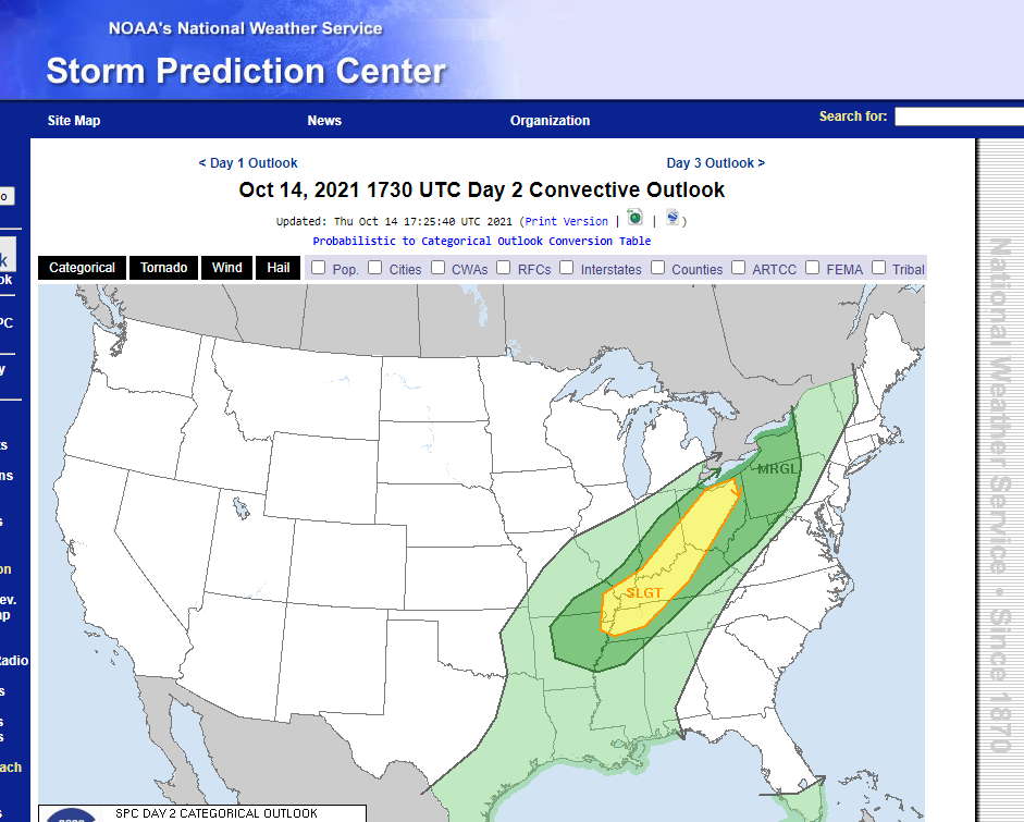
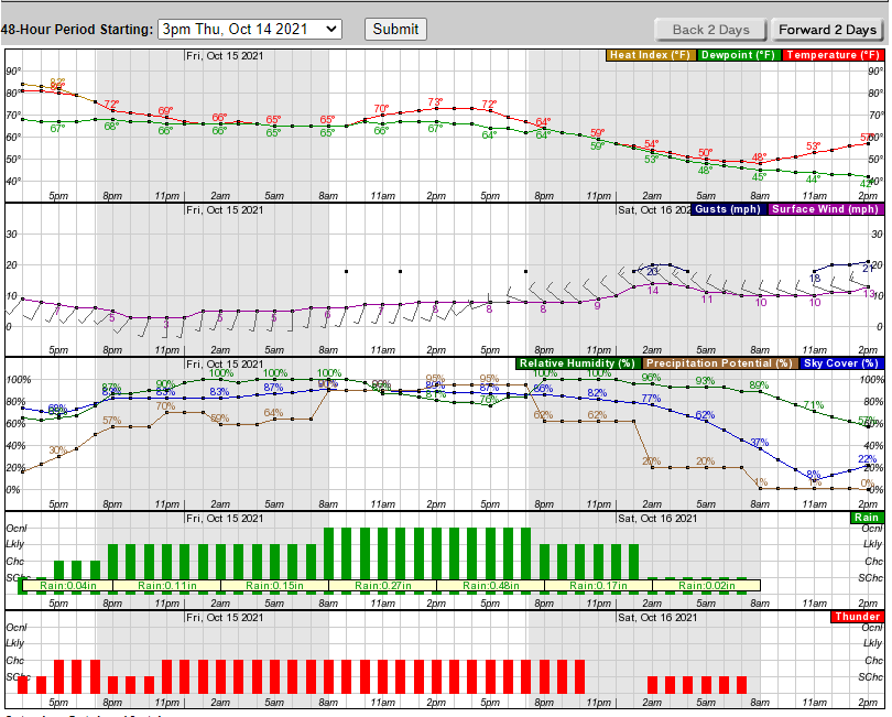
Short Term...(Today through Friday)
Issued at 307 AM EDT Thu Oct 14 2021

Broad warm advection regime ongoing this morning across the Ohio
Valley and advecting deep moisture into the region. This has brought
plenty of cloud cover and in some spots lower stratus. A few showers
were across the Wabash Valley and continued to weaken as they moved
away from the primary areas of lift closer to the cold front back
across western Illinois. Humid conditions currently by October
standards as 0630Z temperatures were in the upper 60s and lower 70s
with dewpoints in the upper 60s as well.

Active and unsettled weather will dominate the short term with
increasing threats for heavier rainfall and embedded convection by
late today throughout the day Friday. Aforementioned cold front
extending from an occluding low pressure over the northern Plains...
then looping through the western Great Lakes back into the mid
Mississippi Valley and southern Plains. The boundary is in a quasi-
stationary state this morning due to a couple factors: 1) the front
has become nearly parallel with broad southwest flow aloft...2) the
front is being left behind by a deep upper low and the northern
Plains surface low which will track north into Manitoba through the
day...and 3) its forward progress is effectively blocked by a large
surface ridge extending from eastern Canada into the southeast
States.

The boundary will drift east slowly today and eventually settle into
the region tonight and Friday which will put central Indiana in the
bullseye for rounds of convection and locally heavy rainfall
beginning late today and persisting through Friday night. The
development of a secondary surface wave on the boundary over the
southern Plains late today will ultimately be partly responsible for
kicking the front east of the region by the beginning of the
weekend. This wave will lift north into the Ohio Valley on Friday
and strengthen as a upper level trough approaching from the west
amplifies late Friday.

Convection is firing along the boundary early this morning in
western Illinois aided by stronger 850mb flow. While some of this
activity may sneak into the northern Wabash Valley later this
morning...expect the bulk of this convection to track N/NE and
remain to the northwest of central Indiana. Additionally...a few
showers and perhaps a rumble or two of thunder will be possible
through early to mid afternoon across the northwest half of the
forecast area...but expect the bulk of the rain will remain in
proximity to the boundary to the west.

The impacts from this multifaceted storm system will come in two
parts with the first one set to commence by late day as the front
approaches our northwest counties and continue tonight and through
Friday morning with the boundary likely to be bisecting the forecast
area from southwest to northeast by predawn Friday. Tropical
moisture from the remnants of Pamela currently over northern Mexico
will continue to advect northeast along the boundary and into the
region over the next 36-48 hours. This will bring unseasonably high
PWATs into the Ohio Valley peaking near the climatological max and
at roughly 250% of normal for mid October. The deep moisture plume
will interact with increasing isentropic lift and a developing
nocturnal low level jet to bring increasing convective coverage in
the zone along and immediately ahead of the cold front tonight
across the northwest half of the forecast area...with some training
of cells as well focused along an axis near or perhaps just north of
a Terre Haute-Indy-Muncie line. Will focus highest pops in this area
overnight with activity likely to be more scattered across southeast
counties. Weak instability aloft will be sufficient for scattered
thunderstorms as well and certainly appears some locations may see
upwards of an inch through Friday morning.

Enhanced low level flow from the southwest will maintain numerous
showers and storms into early Friday afternoon...but the increasing
influence from the approaching upper trough will change the game a
bit for Friday afternoon into Friday evening...as additional
parameters come into play to maintain precip coverage and likely
present an uptick in convective intensity as well. The secondary
surface wave will be in the process of intensifying as it tracks
across the region Friday afternoon...and model soundings/RH progs
both hint at a narrow window for scattering of cloud coverage which
would increase heating and consequently instability. The confidence
level is higher in this occurring south of the region across the
lower Ohio Valley into Tennessee...but increasing BL shear and low
level SRH ahead of the front even up into central Indiana at least
raises the potential for a short 1-3 hour period for severe storms
during the late afternoon and early evening focused mainly across
the southeast half of the forecast area. Damaging winds would be the
main concern but the higher SRH values and presence of directional
shear in the near surface layer at least offers the possibility for
a few rotating cells as well. Lot of moving parts here and would
like to see all of the parameters better phased...but this will be
something to monitor.

To sum it all up...primary concerns remain focused on heavy rain and
the potential for localized flooding with growing confidence at 1-3
inches of rain across much of the forecast area by Saturday morning.
The thermodynamic setup is supportive for embedded thunderstorms
throughout the next 2 days with a slightly higher ceiling for a
short period late Friday afternoon and evening for severe storms.
Rain will continue into Friday night before tapering off early
Saturday as the system moves east. More on the tail end of the storm
system and its impacts in the long term section below.

Temps...Even with a fair amount of cloud cover and limited sunshine
today...should not have much trouble warming into the upper 70s and
lower 80s across much of the forecast area considering our very warm
start this morning. Temperatures on Friday are more challenging with
the boundary draped across the forecast area. Low level thermals
largely support a range from the lower 70s over the northern Wabash
Valley to the upper 70s in the southeast counties. Lows tonight will
range from the upper 50s north to the mid 60s south of Interstate
70.

&&

.Long Term...(Friday Night through Wednesday)
Issued at 307 AM EDT Thu Oct 14 2021

The period will begin as central Indiana is transitioning regimes
from warm/rather humid to cool/quite dry...amid soaking rains and
thunderstorms as a strong cold front crosses the CWA. By Friday
evening, the day`s moderate to locally heavy rainfall will be
tapering off from west to east. Strong, to perhaps briefly severe,
thunderstorms will be possible east of the I-69 corridor as 150-250
m2/s2 of 0-3 km storm relative helicity, and up to 70 kts of 0-6 km
bulk shear attempt to catch what very limited instability may linger
ahead of the front after 00z. Appears the ample dynamics may just
miss this opportunity, although any small variations in the quick
frontal passage`s timing would certainly change the scenario.
Nevertheless after 00z high confidence in rain ending west to east,
moderate confidence in a few lingering heavy downpours east of Indy,
and low confidence in any severe storms.

Saturday will, despite ample sunshine, feature the coolest afternoon
highs since the second week of May...as the region dries out
courtesy of west-northwesterly surface wind gusts as high as 20-25
mph as the exiting system`s upper level trough axis crosses Indiana.
Several dry days of seasonably chilly mornings and pleasant autumnal
afternoons weather will follow, with Gulf moisture cut-off from the
Mid-West by high pressure prevailing over the eastern US. Conditions
will slowly moderate amid modest southwesterly winds out of the
surface ridge axis to our south, and mid level heights slowly rising
as a ridge approaches from the Plains while flattening.  Mostly
clear skies under H850 temps trending from about 5C on Sunday to
near 12C by Wednesday...support slightly below to slightly above
normal temperatures.  The normal max/min for the long term period is
65/45.

Lower confidence surrounds the end of the long range, on where any
wave would develop over the central US as Canadian air descends into
the US, however decent certainty that any slight chance POPs would
hold off until at least after Wednesday.
No comments:
Post a Comment