The radar signal is definitely there!

Tornado Warning
Severe Weather Statement
National Weather Service Wilmington OH
220 PM EDT Thu Mar 14 2024
INC155-KYC041-141830-
/O.CON.KILN.TO.W.0007.000000T0000Z-240314T1830Z/
Switzerland IN-Carroll KY-
220 PM EDT Thu Mar 14 2024
...A TORNADO WARNING REMAINS IN EFFECT UNTIL 230 PM EDT FOR
SOUTHWESTERN SWITZERLAND AND CARROLL COUNTIES...
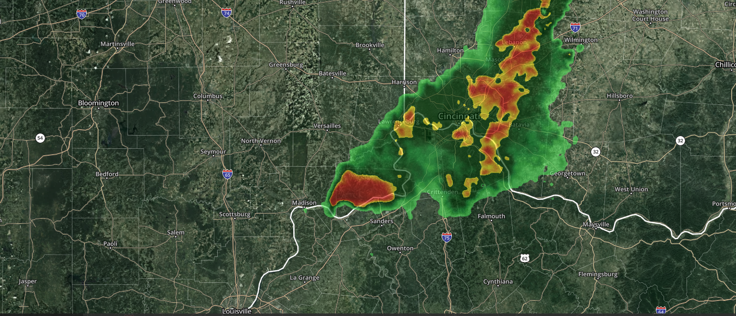
At 220 PM EDT, a radar confirmed tornado was located near
Carrollton, moving east at 45 mph.
HAZARD...Damaging tornado and golf ball size hail.
SOURCE...Radar confirmed tornado. Radar shows tornado debris in the
air.
IMPACT...Flying debris will be dangerous to those caught without
shelter. Mobile homes will be damaged or destroyed. Damage
to roofs, windows, and vehicles will occur. Tree damage is
likely.
Locations impacted include...
Carrollton, Vevay, Ghent, Sanders, Worthville, Prestonville,
Braytown, Interstate 71 at Mile Marker 52, Interstate 71 at State
Route 227, Langstaff, English, Eagle Station, Easterday, General
Butler State Park, and Carson.
This includes I-71 in Kentucky between mile markers 43 and 53.
PRECAUTIONARY/PREPAREDNESS ACTIONS...
To repeat, a tornado is on the ground. TAKE COVER NOW! Move to a
basement or an interior room on the lowest floor of a sturdy
building. Avoid windows. If you are outdoors, in a mobile home, or in
a vehicle, move to the closest substantial shelter and protect
yourself from flying debris.
To report severe weather, go to our website at weather.gov/iln and
submit your report via social media, when you can do so safely.
&&
LAT...LON 3879 8520 3877 8501 3876 8502 3865 8494
3865 8497 3863 8499 3863 8501 3861 8503
3861 8506 3864 8520
TIME...MOT...LOC 1820Z 283DEG 38KT 3870 8517
TORNADO...OBSERVED
MAX HAIL SIZE...1.75 IN
$$
HatzosSevere Weather Statement
National Weather Service Louisville KY
221 PM EDT Thu Mar 14 2024
INC077-141831-
/O.EXP.KLMK.TO.W.0003.000000T0000Z-240314T1830Z/
Jefferson IN-
221 PM EDT Thu Mar 14 2024
...THE TORNADO WARNING FOR SOUTHEASTERN JEFFERSON COUNTY WILL EXPIRE
AT 230 PM EDT...
The storm which prompted the warning has moved out of the area.
Therefore, the warning will be allowed to expire.
To report severe weather, contact your nearest law enforcement
agency. They will relay your report to the National Weather Service
Louisville.
LAT...LON 3869 8520 3870 8522 3873 8525 3875 8525
3875 8520
TIME...MOT...LOC 1821Z 267DEG 39KT 3871 8517
No comments:
Post a Comment