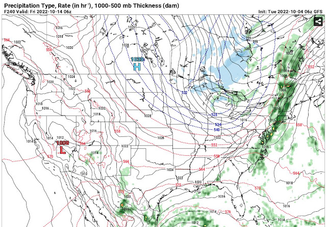
October is our second severe weather season. It is possible to see severe weather and tornadoes because of the clash of cold and warm air masses just like in the spring.
Our first freeze is possible between October 14 and October 19.
#BOTS! Flurries on October 19th?
Here's what the NWS thinks:
Forecast Update...
Issued at 641 AM EDT Tue Oct 4 2022

Minor changes to the forecast this morning. Refined the mention of
patchy fog across our northeastern counties based upon recent
observations and satellite trends. Nudged temperatures north of I-70
down a degree or two, again based upon recent observational trends.
High pressure is currently overhead, and winds have generally
decreased to less than 5kts during the course of the night. A few
locations have even gone calm for multiple hours, and these have
typically been the cooler spots with frost and fog. Given the
expectation of clear skies with light winds through morning, the
continued development of patchy frost and fog is anticipated until
shortly after sunrise.

&&

.Short Term...(Today and tonight)
Issued at 252 AM EDT Tue Oct 4 2022

Through Sunrise

High pressure is currently building into the region, and light
northeasterly winds are diminishing. Some weak cold air advection
throughout the day yesterday has allowed for cooler conditions
compared to the prior overnight period. Many rural stations are
reporting temperatures in the middle 30s as of 06Z. Will carry the
mention of frost for much of the CWA and maintain the Special
Weather Statement. Urban areas

With excellent radiational cooling potential, some patchy ground fog
is possible by morning. Terra Haute recently had a brief period of
visibility under 2 miles. Low-level moisture is quite limited,
however, and widespread fog is not expected. The main forecast
challenge through morning will be the frost coverage.

Today

Any frost or ground fog will dissipate quickly after sunrise once
temperatures begin to rise. Efficient boundary layer mixing may once
again occur this afternoon, and surface dew points may drop to under
32F. Will keep dew points under NBM guidance this afternoon. High
temperatures are expected to be seasonable, around 70, and winds
will remain very light. A few high clouds may be noticeable to our
east early, but these should diminish throughout the day.

Tonight

The center of the surface high will be directly overhead by tonight.
Some air mass modification and the cessation of weak cold air
advection will lead to slightly warmer overnight lows compared to
this morning. While a few instances of frost may occur, most
locations are not expected to be cold enough to support frost. Some
patchy ground fog is possible, but once again not expected to be
widespread. Most likely places for patchy fog would be low points in
the local terrain and farmland with enhanced surface moisture from
evapotranspiration.

&&

.Long Term...(Wednesday through Monday)
Issued at 252 AM EDT Tue Oct 4 2022

* Frost likely with potential freezing temperatures this weekend
* Very low chance for rain around Thursday

Wednesday...

Upper ridging and surface high pressure will continue the dry
conditions. Sunshine and dry air will allow temperatures to peak
above normal in the lower to middle 70s. Afternoon humidity will be
low once again, but with high pressure nearby, winds will be light.
This will help mitigate potential fire concerns.

Thursday into Friday...

A weak upper wave will move through on Thursday, with an accompanying
weak surface trough. Moisture will be limited with the Gulf cut off.
This means little chance of rain, and the models continue to hint at
little if any QPF. Will keep some slight chance PoPs across the
northern forecast area Thursday afternoon. Above normal temperatures
will continue with highs in the mid to upper 70s.

Thursday night, a cold front with significantly colder air behind it
will move through. However, best forcing will be north of the area
closer to an upper low across southern Canada. The upper jet will be
over the area, putting the left exit region north of central
Indiana. This will limit forcing here as well. Moisture will
continue to be limited as well. Thus, odds of any measurable rain
are low. Will continue a dry forecast Thursday night.

As colder air flows in on Friday, some lake enhanced showers may
move into northern Indiana. These should remain north of central
Indiana, so went dry on Friday as well. Thanks to strong cold
advection, highs on Friday will only be in the 50s to around 60.

Saturday and Sunday...

Surface high pressure will move through during the weekend, keeping
the area dry and cool. Highs on Saturday will be in the 50s, with
some southwest flow on the west side of high pressure bringing 60s
for highs on Sunday.

Clearing skies and weakening winds will allow temperatures to dip
into the lower to middle 30s by sunrise Saturday. Frost will become
likely many areas, with the potential for below freezing
temperatures, especially in favored cold spots. Similar conditions
will exit early Sunday morning, but a hint of a southwest wind
should keep temperatures above freezing. Frost will be possible
again though.

Columbus Day...

Upper flow will become zonal or perhaps southwesterly depending on
how an upper low develops across the northern USA. This will allow
for warmer temperatures. At the moment, forcing from the approaching
system looks to remain far enough west to go with a dry forecast.


No comments:
Post a Comment